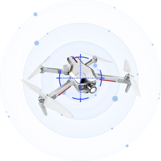
Airborne Drone Detection Is Here: Why Multi-Layer Defense Is Becoming the Standard
Jul 30 2026
At Eurosatory 2026 in Paris, one product demo got more than the usual share of attention from counter-drone professionals: an RF detection payload mounted on a quadcopter, flying above the exhibition grounds and feeding live drone positions to a ground station. The product is the Hawk T1 from Aaronia, and it represents something that has been discussed in white papers for years but rarely seen in production: airborne drone detection.
Putting a sensor in the air is not a gimmick. It addresses a real physical limitation that every ground-based system faces. Radio frequency signals at the frequencies drones use travel mostly by line of sight. Trees, buildings, terrain contours, and even the curvature of the Earth cut into detection range. A sensor elevated by 100 meters sees over those obstacles. A sensor on a drone that can reposition itself sees even more.
The Hawk T1 is a compact RF unit designed to be carried by a standard commercial UAV platform. It scans the 400 MHz to 6 GHz spectrum, the same range that covers DJI OcuSync, Autel SkyLink, and most common DIY drone video links. It feeds its findings back to a command interface on the ground. The concept is straightforward: instead of waiting for a drone signal to reach a fixed mast, you send the sensor to where the signal is easier to catch.
One layer was never enough
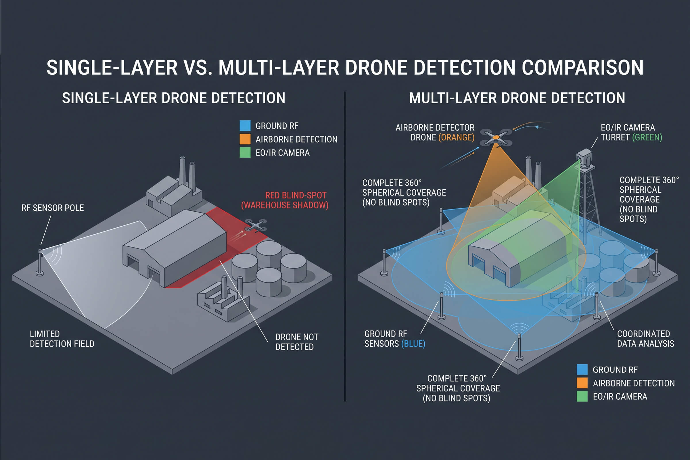
For the first few years of the counter-drone industry, the typical deployment looked like this: mount an RF sensor on a pole, point it at the sky, and wait. This worked reasonably well for flat, open sites like airports and desert borders. It worked less well in urban environments, forested areas, and anywhere with significant vertical structures.
The physics of ground-based RF detection create three persistent problems. First is terrain shadowing. A drone flying low behind a hill or a row of warehouses is simply invisible to a sensor sitting at ground level. Second is multipath interference in cities, where signals bounce off buildings and arrive at the sensor from multiple directions, degrading direction-finding accuracy. Third is the inverse-square law itself. Signal power drops with distance, and at ranges beyond a few kilometers, even a high-gain antenna struggles to pull a consumer drone’s control signal out of the noise floor.
Airborne detection does not solve all of these problems, but it addresses the first one directly. A sensor at 120 meters altitude has a radio horizon of roughly 40 kilometers, compared to about 5 kilometers for a sensor mounted 2 meters above ground. The gain in effective coverage is not linear. It is geometric.
The Hawk T1 is not the only recent development pushing toward multi-layer architectures. Across the industry, the conversation has shifted from ‘which single sensor technology is best’ to ‘how do we combine sensors at different altitudes and modalities to create coverage that has no gaps?’ This is not about replacing ground sensors. It is about filling the spaces they miss.
How LZ TECH builds the layers
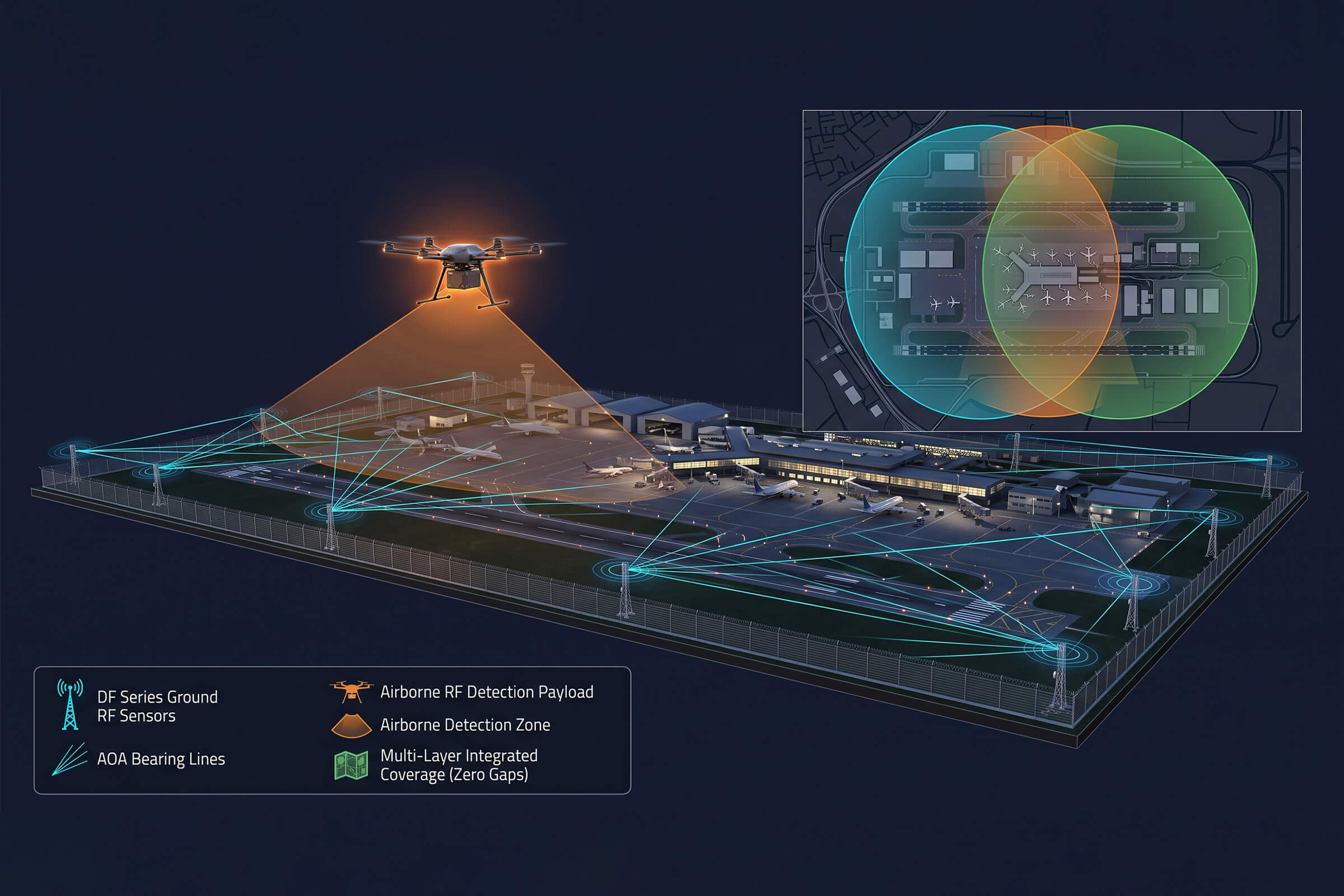
LZ TECH’s product line was designed with multi-layer detection in mind, even if the company does not always market it that way. Consider three products that, when deployed together, create detection coverage from ground level to airborne to electro-optical verification.
The DF Series is the ground layer. Operating from 30 MHz to 6 GHz with a detection range of up to 8 kilometers, these fixed-site passive RF sensors form the backbone of a networked detection grid. The DF Series uses angle-of-arrival direction finding with an accuracy of 3 degrees for a hovering drone and 10 degrees for a moving target. When multiple DF nodes are networked together, TDOA positioning narrows the location estimate to a precise coordinate. Because the DF Series is entirely passive and receives only, it emits no signals and presents no interference risk to surrounding communications. A 360-degree detection envelope means nothing slips through a gap in the azimuth coverage.
The D5-Air is the airborne layer. It is an RF detection payload designed to mount on a commercial UAV platform such as the DJI M400 or M350. Its detection band spans 400 MHz to 6 GHz, and it achieves a detection range of up to 5 kilometers from the airborne position. The prototype drone is not included in the product. The customer supplies their own UAV and mounts the D5-Air payload, making the total system cost dependent on the platform choice. Once airborne, the D5-Air extends the detection footprint vertically and horizontally, covering terrain shadows and urban canyons that a ground node cannot reach. It feeds real-time intelligence back to the command center, turning a blind spot below a hill or behind a stadium wall into monitored airspace.
The VAR300 is the verification layer. RF detection tells you a drone is present and gives you coordinates. But for a security team that needs to decide whether to escalate, coordinates are not enough. They need visual confirmation. The VAR300 is a fixed electro-optical and infrared surveillance system that operates continuously, 24 hours a day. In daylight, it detects a DJI Mavic 3 at 1 kilometer or more and tracks it beyond 1.5 kilometers. At night, its VOx uncooled infrared detector with 640 by 512 resolution picks up the same target at 500 meters for detection and 800 meters for tracking. The built-in AI recognition engine distinguishes drones from birds and other moving objects, reducing false alarms. When a DF Series node passes a target coordinate to the VAR300, the camera slews automatically to the bearing and begins tracking before a human operator even touches a control.
These three layers are not theoretical. They are products that exist today and ship to customers in over 60 countries. The DF Series detects. The D5-Air goes where ground sensors cannot. The VAR300 confirms. Together they form a detection architecture that addresses the line-of-sight problems a single ground sensor cannot solve.
The real question is integration, not sensor count
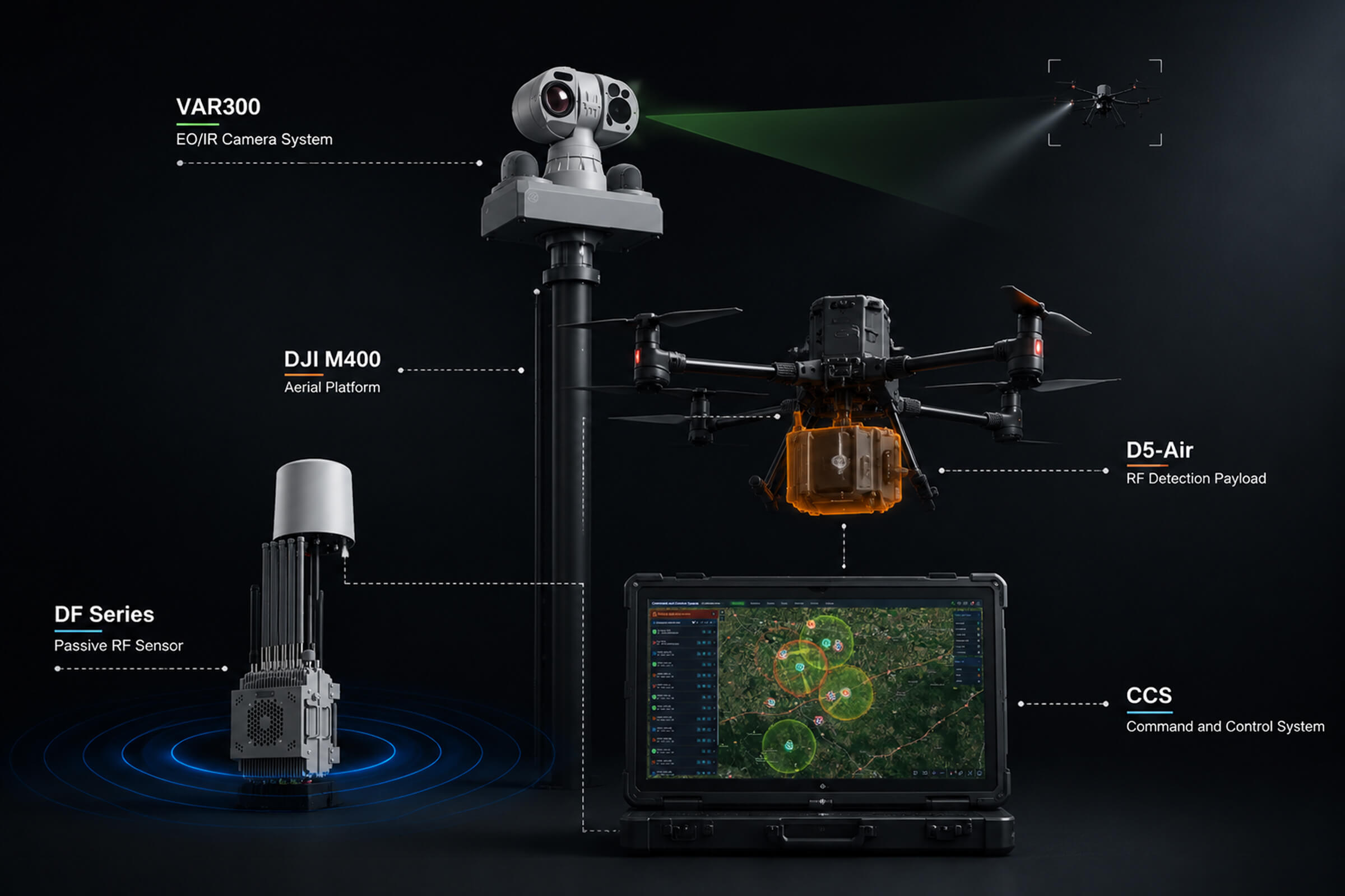
Adding an airborne sensor sounds appealing. It also adds complexity. Every additional sensor layer generates more data. Without a command and control platform that fuses inputs from multiple sensor types into a single operational picture, the operator ends up staring at three different screens with three different coordinate systems, trying to figure out whether sensor A and sensor B are looking at the same drone or two different ones.
This is where the software layer matters as much as the hardware. LZ TECH’s CCS and CRPCS platforms ingest detection data from the DF Series ground nodes, the D5-Air airborne payload, and the VAR300 electro-optical tracker, then fuse them into a single geospatial display. An operator sees one map with all targets overlaid, not three separate feeds. When a drone appears simultaneously on two DF nodes and the D5-Air, the system correlates the tracks and presents a single threat icon rather than three confusing dots. The software handles the sensor fusion so the operator can focus on decisions.
The industry’s movement toward multi-layer architectures is a natural evolution. Ground sensors alone were a reasonable starting point when the drone threat was simpler, and the counter-drone market was smaller. But as drones get faster, smaller, and more autonomous, and as the environments they operate in get more complex, detection architectures need to match. Airborne sensors like the Hawk T1 are a signal that the market is ready for this next step. The companies that already have the ground, airborne, and verification layers in production are the ones positioned to deliver it.
LZ TECH’s approach to multi-layer detection follows a simple principle: every sensor modality covers the gaps of the others. RF detects at range but can struggle with terrain. Airborne eliminates terrain shadowing but has limited flight time. Electro-optical confirms identity but needs a target bearing to start its search. Combined, the gaps close. The result is detection coverage that a single sensor, no matter how advanced, cannot provide on its own.
Connect with us
Ready to Secure Your Low-Altitude Airspace?