From Single Point to Network: Drone Detection for Borders and Long Perimeters
Aug 20 2026
Why Long Perimeters Break Single-Point Detection
A border crossing, a pipeline corridor, a coastline, a facility fence line that runs for tens of kilometers. These are the sites that quietly defeat most drone detection systems. The problem is not that the sensors are weak. It is that the geometry does not cooperate.
A single detection unit, no matter how sensitive, sees the airspace from one fixed point. Range falls off with distance. Terrain blocks line of sight. A drone flying low behind a ridge or a stand of trees disappears from a lone sensor’s view. Along a long, irregular perimeter, the only thing a single point gives you is a single point of failure, and a long list of blind spots.
The shift from single-point to network coverage is the defining challenge of long-perimeter drone defense. It changes what you buy, where you place it, and how the pieces talk to each other.
The Physics of Perimeter Coverage
Two physical realities shape every long-perimeter deployment. First, radio frequency detection is fundamentally line-of-sight. A detection system operating in the 30 MHz to 6 GHz band sees a drone’s command-and-control signal as long as there is a clear path between the drone and the sensor antenna. Hills, buildings, heavy vegetation, and the curvature of the earth all interrupt that path.
Second, detection range is a maximum, not a guarantee. A sensor rated for eight kilometers will reliably see a low-flying drone at a fraction of that distance, because the drone’s signal has to compete with terrain, weather, and the clutter of the surrounding RF environment. A drone hugging the ground a few hundred meters from the sensor can be harder to detect than a drone flying high and clear at five times the distance.
The consequence is that coverage is a question of geometry, not just equipment quality. To cover a long perimeter without gaps, you need multiple sensors placed so their coverage areas overlap. Each sensor covers its own sector. The overlaps are what close the gaps. That is what a network gives you that a single point cannot.
Two Ways to Find a Drone: Direction Finding vs. Positioning
When you network sensors along a perimeter, the next question is what each node contributes. There are two complementary approaches, and they answer different questions.
Direction Finding: Where Is the Signal Coming From?
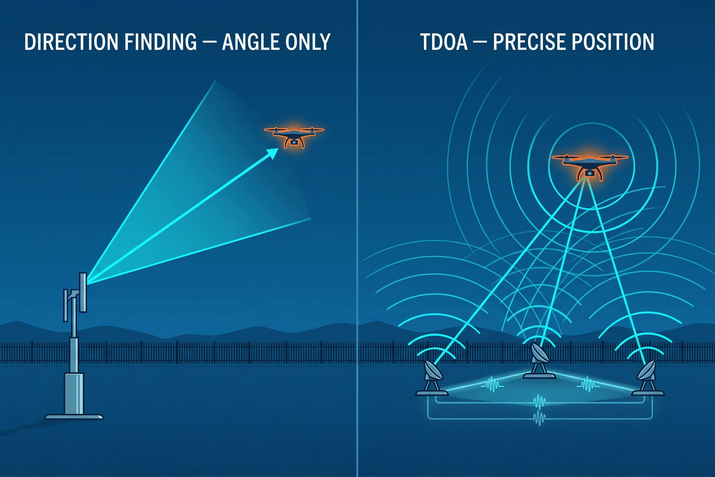
Direction-finding systems like the DFJ83 and DFJ53 measure the angle of arrival of a drone’s radio signal. A single DFJ83 unit detects a drone at up to 8 km and computes its bearing with a direction-finding accuracy of 3 degrees RMS or better. That tells the operator the direction of the threat but not its exact position along that bearing. It is a line, not a point.
Deploy two or three direction-finding units across the perimeter and the picture sharpens. Each unit draws its own bearing line. Where the lines cross is the drone. This is triangulation, and it is the oldest and most robust way to locate a radio source without emitting anything.
The trade-off is precision versus simplicity. Triangulation from two or three widely spaced direction-finding units gives a useful position estimate, but the accuracy depends on the geometry. When the drone is far outside the triangle formed by the sensors, the bearing lines cross at a shallow angle and the position estimate degrades. That is why direction finding is best suited to early warning and cueing, and why precise localization is handed off to a technique built for it.
TDOA Positioning: Where Is the Drone, Precisely?
Time Difference of Arrival, or TDOA, is a different and more precise technique. Instead of measuring the angle of a signal, a TDOA network measures the tiny difference in the time a drone’s signal reaches three or more synchronized receivers. Because radio waves travel at a known speed, those time differences convert directly into a position.
The D5-B is a passive TDOA node built for exactly this role. A single D5-B covers the 30 MHz to 6 GHz band with a detection range of up to 3 km and a detection height of up to 1 km. It tracks more than 30 drones simultaneously and delivers a positioning accuracy better than 10 m RMS, with a response time of 2 seconds or less. Because it is a passive receiver, it emits nothing, runs on standard AC power at around 60 watts, and is built to IP66 for year-round outdoor duty in temperatures from minus 40 to plus 70 degrees Celsius. At 3 kg, it deploys on a fixed mast or a temporary tripod in minutes.
The difference between the two approaches matters. Direction finding gives you a bearing and, with multiple units, a rough position. TDOA gives you a precise position directly. In practice, a well-designed perimeter uses both: direction finding for early detection and rough cueing, TDOA for precise localization when the drone gets close enough to matter.
Adding the Third Dimension: Airborne Coverage
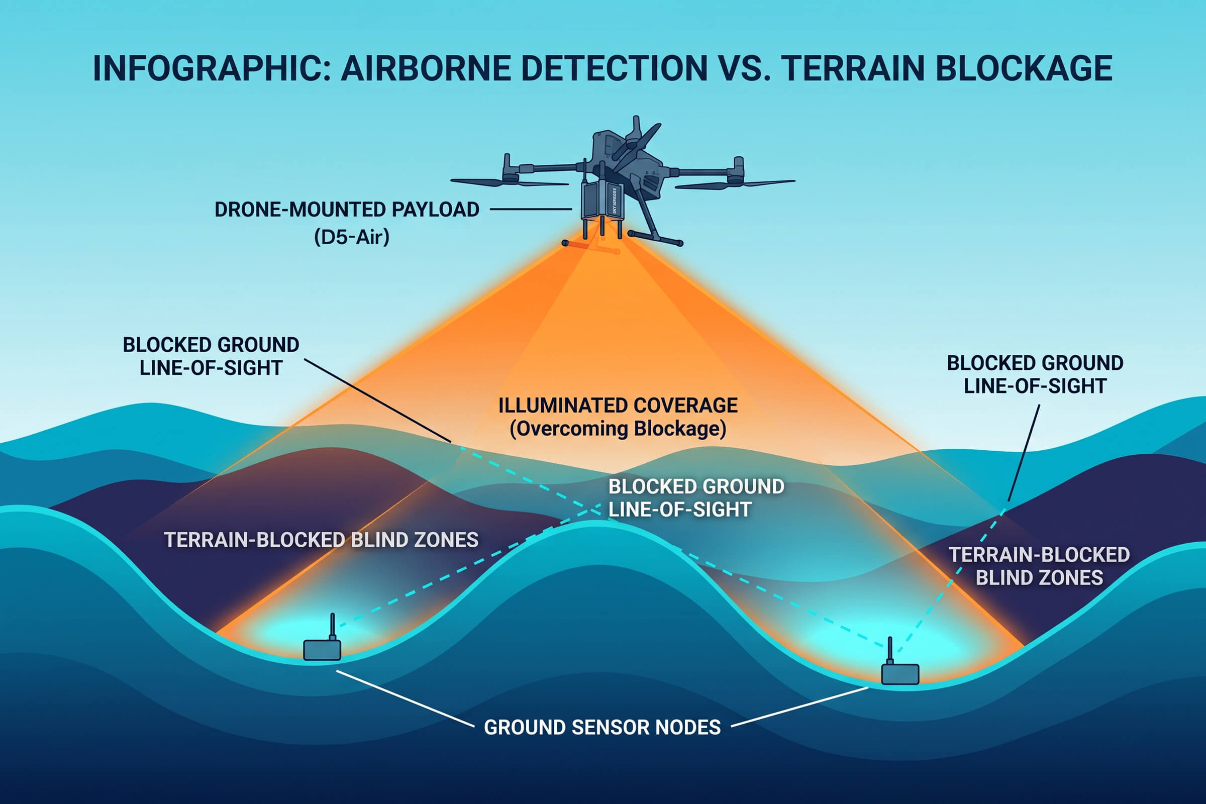
Ground-based sensors share a common limitation: they see the world from roughly eye level, and the terrain between them and a low-flying drone is full of obstructions. An airborne sensor removes that limitation.
The D5-Air is a drone-mounted detection payload that operates in the 400 MHz to 6 GHz band with a detection range of up to 5 km. Mounted on a platform such as the DJI M400 or M350, it climbs above the terrain and looks down into the valleys, behind the ridgelines, and across the water where ground nodes cannot see. Airborne nodes extend the network vertically, filling the coverage gaps that terrain creates for ground-based sensors.
This is not a replacement for ground infrastructure. It is a complement. A long-perimeter network works best when fixed ground nodes provide continuous baseline coverage, and airborne nodes are launched to close specific gaps, investigate ambiguous contacts, or respond to a fast-moving threat that has slipped behind terrain.
Designing the Network: Nodes, Spacing, and Handoff
The practical design questions for a long-perimeter deployment are spacing, redundancy, and handoff.
Spacing is driven by the detection range of the node and the terrain it must cover. A DFJ83 with an 8 km detection range can cover a longer stretch than a DFJ53 with a 5 km range, but only where the terrain allows a clear line of sight. In flat open terrain, nodes can be spaced near their maximum range, with overlap to eliminate gaps. In broken terrain, spacing tightens and the network grows denser.
Redundancy means no single node is critical. If one sensor goes down for maintenance or fails, its neighbors expand their effective coverage to close the gap. A network designed with overlapping sectors tolerates the loss of any single node without opening a hole in the perimeter.
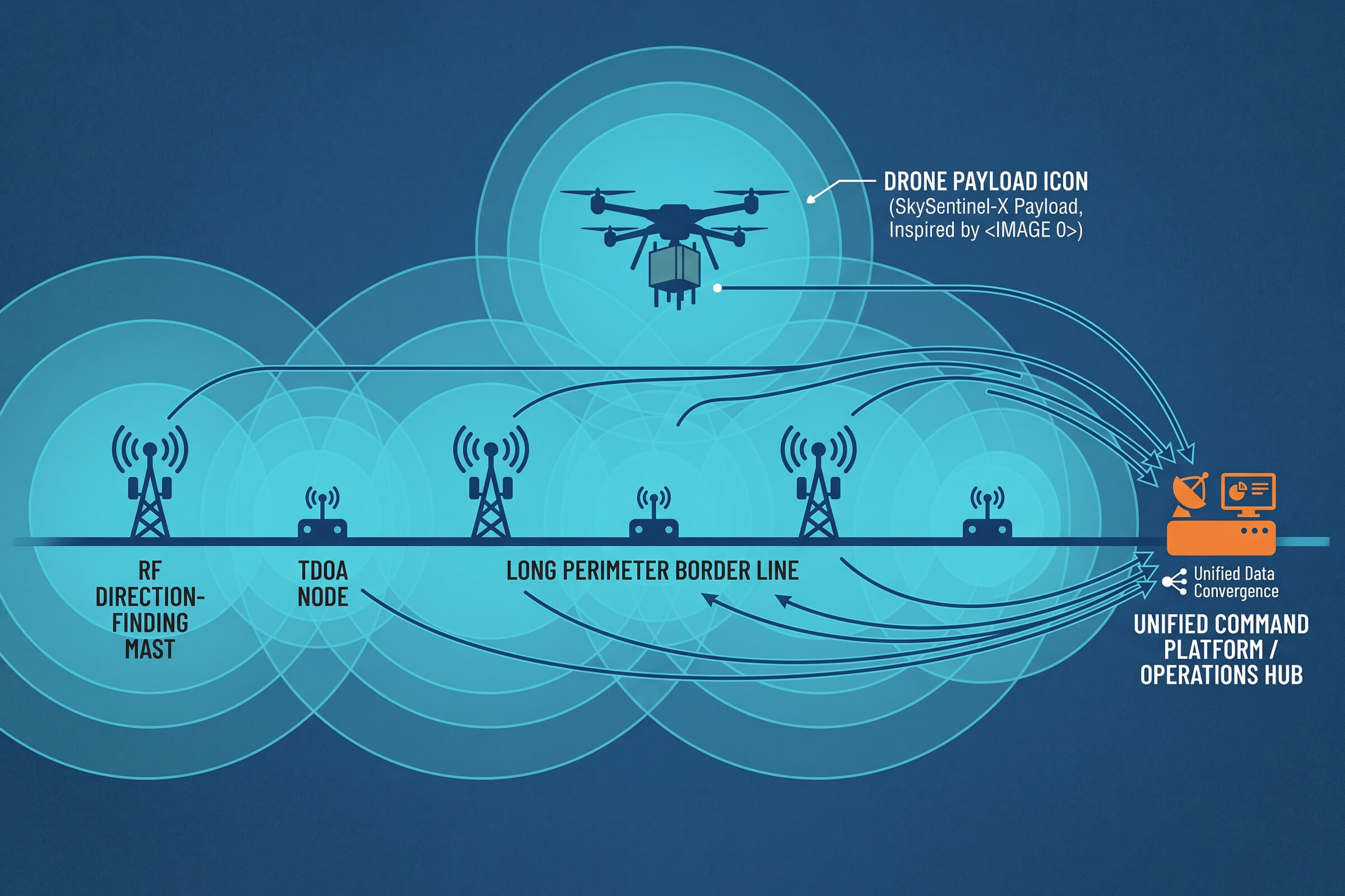
Handoff is what happens when a drone crosses from one node’s sector into another’s. In a network, the tracking of a moving drone should transfer cleanly from node to node, with the position estimate becoming progressively more accurate as more sensors contribute. This requires a command layer that fuses the feeds from every node into a single track. That is the same principle that separates a collection of sensors from a coordinated defense.
Why Passive Matters Along a Perimeter
One property of the network is worth stating plainly: the detection layer along a long perimeter should be passive. Direction finding and TDOA both work by receiving, not emitting. A DFJ83 direction-finding unit and a D5-B TDOA node both listen for drone signals and never transmit.
This has practical consequences. Passive detection does not interfere with legitimate radio traffic, the communications, navigation, and broadcast systems that operate near any border or infrastructure corridor. It does not require spectrum licenses or special authorizations in most jurisdictions. And it does not announce its own presence: a drone operator cannot detect a passive receiver the way they can detect an active radar sweep. For a long perimeter where the goal is continuous, unobtrusive monitoring, passive detection is the right foundation.
There is an operational benefit too. Because a passive network emits nothing, it can run indefinitely without drawing attention, building a continuous record of airspace activity that becomes the baseline for recognizing what is normal and what is not.
Passive operation also simplifies power and backhaul in remote terrain. A TDOA node drawing around 60 watts can run from a small solar or battery-backed supply where grid power is unavailable, and its data rides a modest network link. The lighter the infrastructure footprint, the more practical it becomes to deploy detection nodes along a border stretch that sits far from any control room.
From Single Point to Network: A Practical Progression
Facilities rarely leap from nothing to a full perimeter network in one step. A more common progression starts with a single high-risk sector.
Step one is to cover the most exposed sector with a direction-finding unit, a DFJ83 or DFJ53, placed at the point of highest traffic or greatest vulnerability. This establishes a detection baseline and begins documenting drone activity in the sector.
Step two adds TDOA nodes. As the D5-B network grows from two to three to four nodes, the system shifts from detecting drones to precisely locating them. The position data now supports a real response, not just an alert.
Step three extends the network along the full perimeter, adds airborne D5-Air coverage for terrain-blocked sectors, and connects everything through a command platform that fuses the feeds into one airspace picture. At this stage, the facility has moved from a single point of detection to a coordinated, redundant, precise network. That is the difference between knowing a drone is out there somewhere and knowing exactly where it is, right now.
The Bottom Line for Long-Perimeter Sites
Long perimeters are where drone detection systems earn their keep, and where weak designs fail first. The site that installs one powerful sensor and declares the perimeter covered has solved the easiest part of the problem. The hard part is the geometry: the terrain, the gaps, the blind spots, and the need for coverage that survives the loss of any single node.
The answer is not a better single sensor. It is a network. Direction finding for early detection. TDOA for precise positioning. Airborne nodes for terrain gaps. A command layer that fuses it all into one picture. For borders, coastlines, pipelines, and facility fences, that is the difference between monitoring a point and defending a line.
Connect with us
Ready to Secure Your Low-Altitude Airspace?