Drone Threats to Energy Infrastructure: A Layered Detection Approach
Aug 20 2026
A Different Kind of Target
An oilfield, a gas processing plant, a power station, a solar farm, a substation. These sites share a trait that makes them uniquely exposed to drone threats: they are large, spread out, and packed with assets that cannot be moved. They also sit far from population centers, where airspace is loosely monitored, and a drone can approach from almost any direction.
For an energy operator, a drone is not just an airspace violation. Over a tank farm or a processing unit, a drone is a potential ignition source. Over a substation or a transmission line, it is a tool for reconnaissance that precedes more serious interference. The risk profile is different from that of an airport or a stadium, and the defense design has to match it.
What Makes Energy Sites Hard to Protect
Three factors make energy infrastructure a difficult C-UAS problem.
First, the scale. An oilfield can span hundreds of square kilometers, with wells, gathering stations, processing units, storage tanks, and pipelines scattered across the terrain. There is no single perimeter to fence, and no single choke point to monitor. A facility that can be walked end to end in an afternoon is one kind of problem. A facility that takes an hour to drive across is another, and the detection design has to account for that difference.
Second, the hazard. Energy sites contain flammable and explosive materials. Crude oil, natural gas, hydrogen sulfide, and refined products all change the stakes of an unauthorized flight. A drone that would be a nuisance over a warehouse is a genuine hazard over a tank farm. The concern is not just what the drone is carrying, but where it is flying and what it could strike or ignite.
Third, the remoteness. Many energy sites operate in deserts, coastal zones, or mountainous regions, far from the dense airspace monitoring of urban areas. Operators cannot rely on the surrounding air traffic infrastructure to flag an intruder. They need their own detection because no one else is watching the sky above them.
Layered Detection for Dispersed Assets
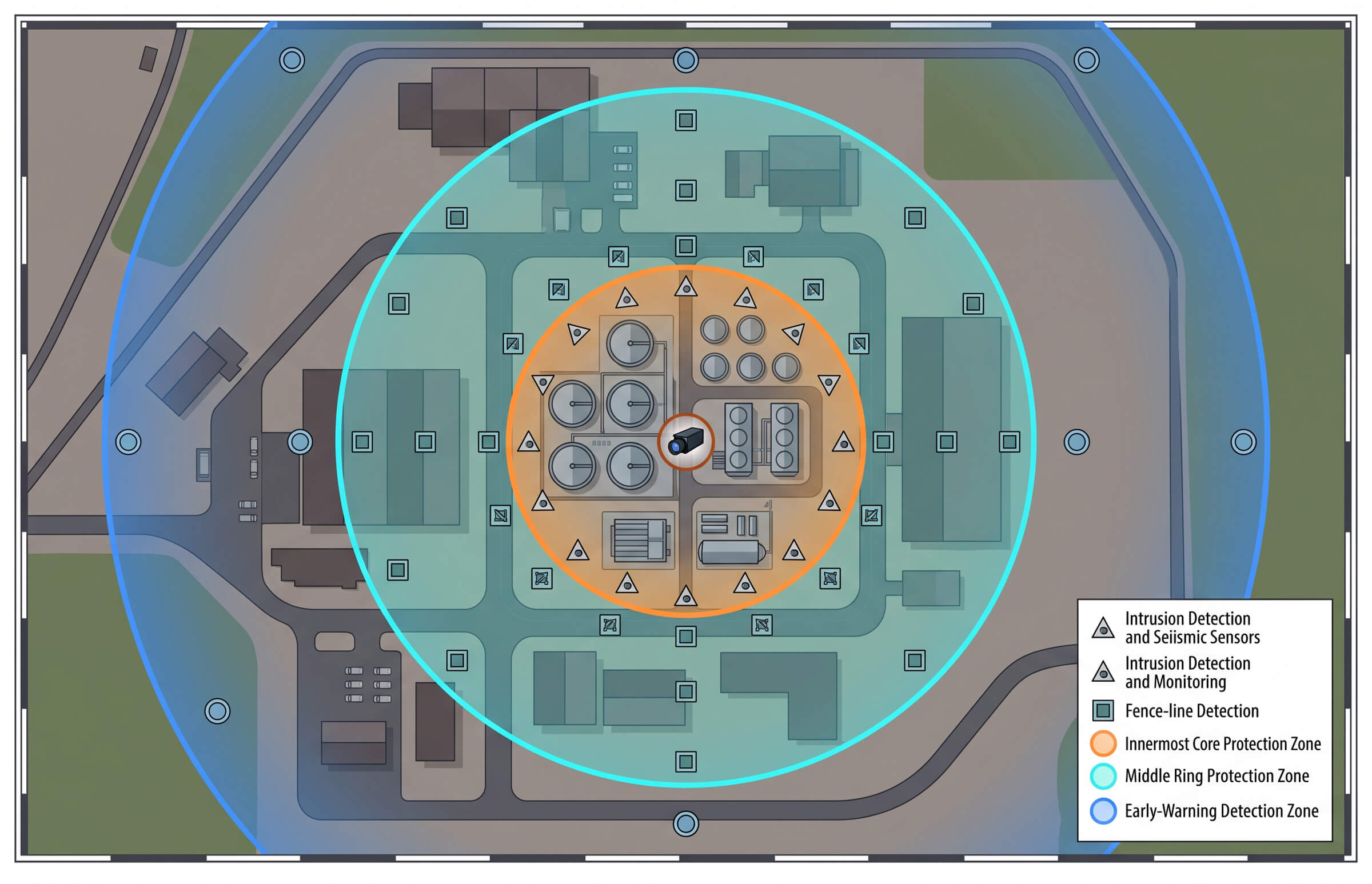
The right architecture for an energy site is layered, matching the natural structure of the facility: a wide early-warning ring around the outer boundary, a denser detection layer around the operating core, and a precise confirmation layer over the most critical assets.
The Warning Ring: Early Detection at Range
The outer layer uses fixed detection units to establish a wide early-warning ring. The DF5 Max is built for this role. It monitors the 400 MHz to 6 GHz band with a detection distance of up to 5 km and a direction-finding distance of up to 3 km, providing a direction-finding accuracy of 10 degrees RMS or better. It covers a full 360 degrees, tracks more than 35 drones simultaneously, and is rated IP66 for continuous outdoor operation in temperatures from minus 40 to plus 65 degrees Celsius.
Placed at the edges of the site, DF5 Max units give operators the earliest possible warning of an approaching drone. The goal of this layer is not precision. It is time. Every second of advance notice is a second the response team has to confirm, assess, and act.
The Core Layer: Dense Detection and Confirmation
Closer to the operating core, the detection density increases. Airborne D5-Air payloads operating in the 400 MHz to 6 GHz band extend detection over terrain that ground units cannot see, while the VAR300 adds electro-optical confirmation.
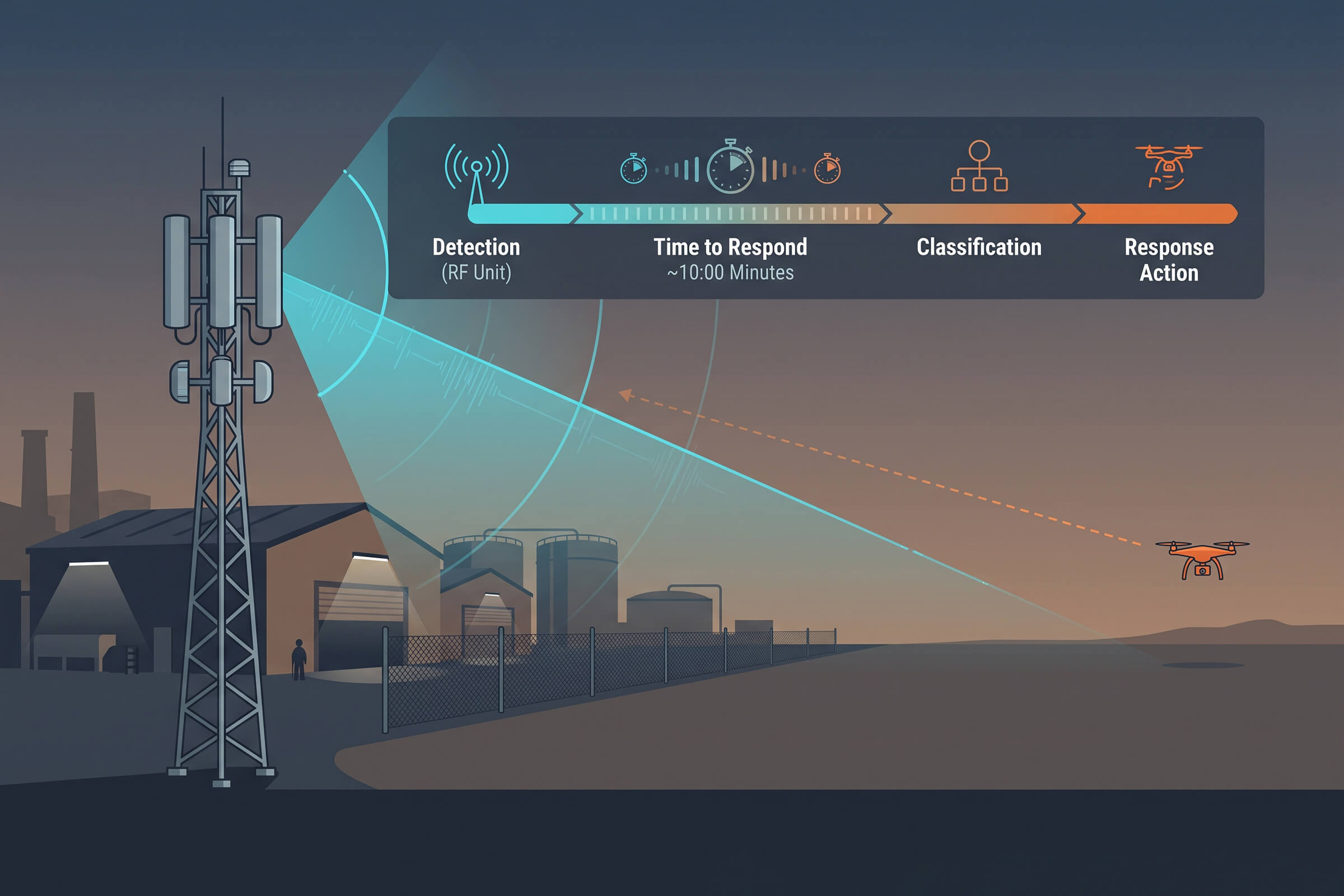
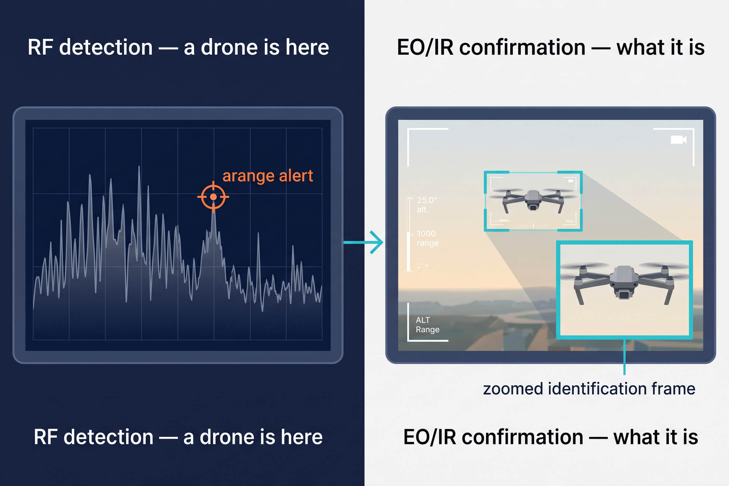
The VAR300 is an all-weather electro-optical and infrared tracker that provides visual confirmation of a detected contact. Where the RF layer tells an operator that a drone is present, the VAR300 tells them what it looks like. A commercial quadcopter, a fixed-wing survey aircraft, or something else. That visual confirmation is the difference between treating every RF contact as a threat and responding only to the ones that matter. It is also the layer that captures the video evidence needed for a later report or investigation.
Detection First, Response Second
A common mistake in energy-site drone defense is to jump straight to countermeasures before building the detection layer. The detection layer is where the operational value sits for three reasons.
First, detection is what tells you whether there is a problem at all. Most RF contacts near an energy site are not threats. They are commercial drones passing overhead, agricultural survey aircraft, or hobby flights in the general area. Without detection and identification, the operator has no way to tell which contacts deserve a response.
Second, detection builds the evidence base. Every logged contact, with its frequency, bearing, time, and visual record, contributes to a picture of what is normal and what is not. Over time, that picture is what lets the operator distinguish a routine overflight from a reconnaissance pattern. The drone that flies the same route three nights in a row is a different problem from the one that passes once and never returns, and only a continuous detection log reveals the difference.
Third, detection is the legally safe layer. Passive RF detection and electro-optical confirmation face few regulatory barriers in most jurisdictions, where active countermeasures may be restricted or require specific authorization. Building the detection layer first means the site is protected and compliant from day one, without waiting on the regulatory questions that surround more active measures.
Matching Coverage to the Threat, Not the Budget
The temptation in energy-site security is to buy the most powerful sensor and place it at the center of the site, expecting it to cover everything. The geometry does not work that way. A single central sensor leaves the outer reaches of a dispersed site uncovered, and the critical assets at the core are the ones that need the most protection, not the least.
A better approach matches coverage to asset priority. The operating core, the wells, processing units, and storage tanks get the densest, most redundant detection, with overlapping RF coverage and electro-optical confirmation on the highest-value assets. The surrounding area gets sparser early-warning coverage, enough to flag an approaching drone with time to spare. The result is a coverage map that reflects the actual risk, not a uniform blanket that protects everything equally and nothing well.
This principle holds at every scale. A small site still puts its densest coverage on the assets that matter most. A large site simply adds more rings, more nodes, and more confirmation layers as the geography expands. The logic does not change, only the number of sensors.
The Role of a Command Layer
An energy site with multiple DF5 Max units, D5-Air payloads, and VAR300 trackers is generating detection data from a dozen or more sources. Without a command layer to fuse that data, the operator is staring at a wall of separate feeds, trying to correlate them by hand. That is where the value is lost.
A command platform brings the feeds together onto one geographic display, fuses the RF tracks with the visual confirmations, and presents the operator with a single coherent picture of the airspace. It is the difference between a collection of sensors and a defense system. For a dispersed energy site, the command layer is not optional. It is what turns geographically scattered detection into a coordinated response.
The command layer also solves a staffing problem. Energy sites often run lean, with a small operations team covering a large area. A fused display means one operator can monitor the entire site’s airspace from a single station, instead of needing a person per sensor. That is a meaningful difference when the alternative is leaving gaps unattended.
A Practical Starting Point for Energy Operators
For an energy operator building a drone defense capability from scratch, the sequence matters.
Start with the warning ring: DF5 Max units at the edges of the site, establishing early detection and beginning to log activity. Add confirmation: VAR300 trackers on the highest-value assets, so that detection is followed by visual identification. Extend coverage: D5-Air payloads for terrain gaps and dispersed outer areas. Connect it all: a command platform that fuses every feed into one picture.
Each step adds capability on top of the previous one, and each step is compliant, passive, and immediately useful on its own. The site does not need to solve the whole problem at once. It needs to start detecting, start confirming, and start building the evidence base that will guide the next investment.
This staged approach also spreads cost over time. Instead of a single large capital outlay, the operator builds capability incrementally, and each stage generates the data that justifies the next. The warning ring proves the need. The confirmation layer proves the response. The command layer proves the value. By the time the full system is in place, its case has already been made with evidence, not assumption.
Regulatory and Insurance Drivers
The case for energy-site drone detection is increasingly driven by two forces beyond the immediate threat. The first is regulation. As airspace authorities extend drone-safety rules around critical infrastructure, operators face growing pressure to demonstrate that they monitor and manage low-altitude airspace over their sites. A facility with a documented detection capability is better positioned to show compliance than one without.
The second is insurance. Underwriters pricing a large energy facility increasingly ask about drone risk, and a site that can show continuous airspace monitoring and a logged detection history negotiates from a stronger position than one that cannot. Neither of these forces is a direct attack. Both are real, and both favor the operator who builds detection before it becomes a requirement rather than after.
The Energy-Site Difference
Energy infrastructure is where drone detection stops being a security nicety and becomes an operational requirement. The scale of the sites, the hazard of the materials, and the remoteness of the locations all raise the stakes of an unauthorized flight. A drone over a tank farm is not the same problem as a drone over a warehouse, and it should not be solved with the same off-the-shelf answer.
The answer that fits is layered: a wide warning ring, a dense detection core, electro-optical confirmation on the critical assets, and a command layer that fuses it all. For energy operators, that is the difference between hoping a drone is not a problem and knowing, with time to act, when one is.
Connect with us
Ready to Secure Your Low-Altitude Airspace?