Border Low-Altitude Surveillance: What the Black Sea Frontier Teaches
Sep 04 2026
A Gap on the Black Sea Frontier
In August 2026, a drone crossed the Romanian border and exploded near Kardam in Bulgaria, roughly a hundred meters from the frontier and a kilometer from a cross-Balkan natural gas compressor station. Neither country detected it in time. Bulgaria responded by shifting some of its border counter-drone assets toward Romania and stating a need for around ten detection-and-neutralization systems. Days later, a drone was spotted flying near the Neptun Deep offshore gas project in Romanian waters.
In the same month, Moldova reported five drones entering its airspace from multiple directions during a large air assault on Ukraine and opened an investigation into fallen debris. None of these were isolated incidents. Together, they describe a border problem that has outgrown the single-sensor, single-point response.
Why Borders Break Single-Point Detection
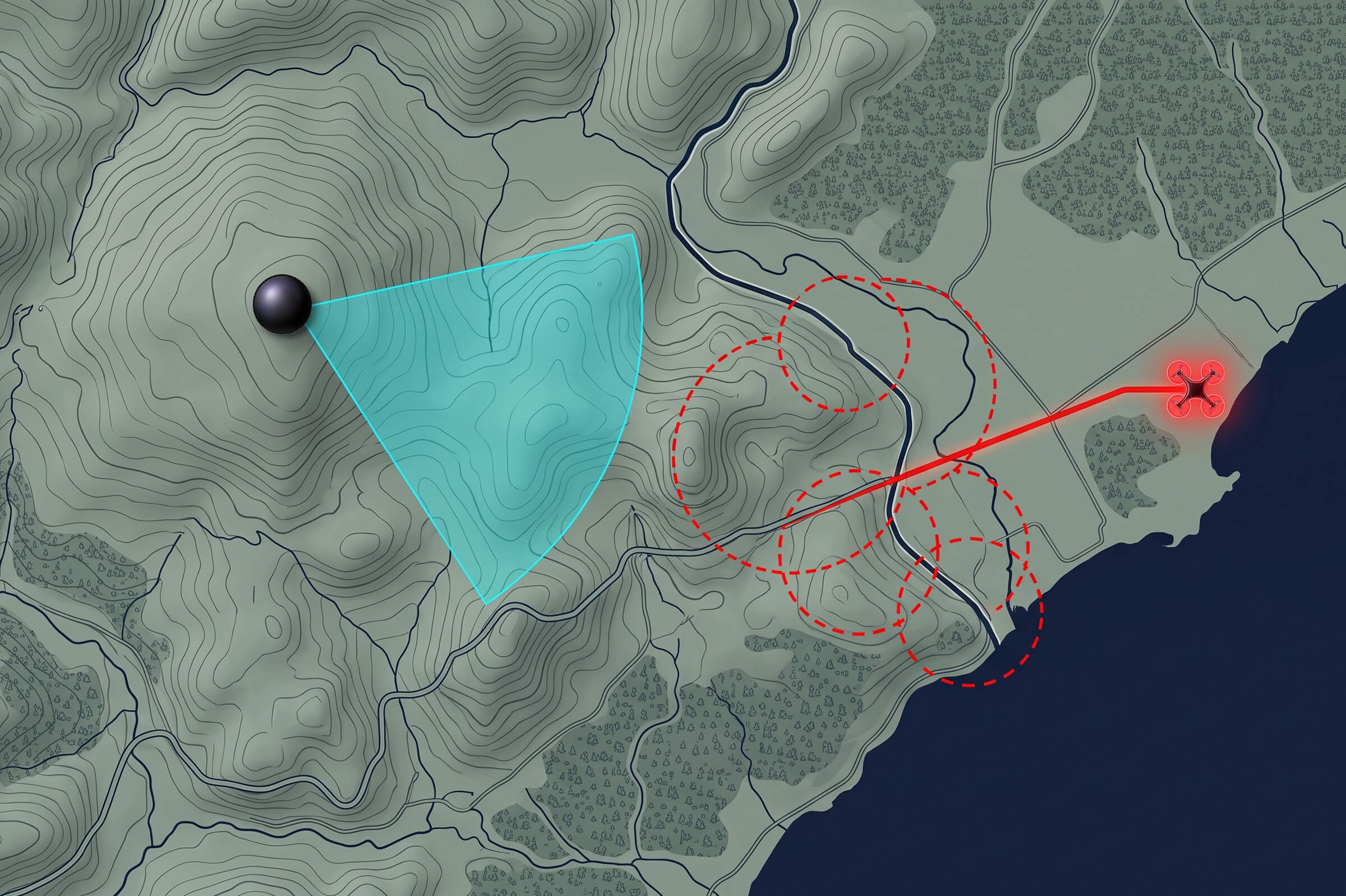
A border is not a facility. It is a line that runs for hundreds of kilometers through terrain, weather, and open sky, and a drone can cross it anywhere. A single detection unit, no matter how sensitive, watches from one fixed point, and its range falls off with distance and terrain. A drone crossing twenty kilometers away is invisible to it.
The consequence is that border airspace is defended in fragments. Each node covers a sector, and between the sectors there are seams, and the seams are where the drones cross. Closing the seams is not about buying a better sensor. It is about buying a network, and about the property that makes a border network different from a facility one: it must be passive.
Why Passive Matters Along a Border
Along a border, the detection layer has to run continuously, often in remote terrain, without touching the radio environment around it. Border regions are full of legitimate traffic: civil aviation, communications, and the systems of neighboring communities. A detection approach that transmits risks interfering with what it is meant to protect, and it reveals its own positions.
Passive detection sidesteps both problems. It emits nothing, so it cannot interfere with legitimate traffic and cannot be found by the operator it is trying to catch. It also runs lean. A passive node drawing tens of watts can be powered in remote terrain far more easily than an active one, and it can watch around the clock without the cost and footprint of a transmitter. For a border, passive is not a preference. It is the condition that makes continuous coverage possible.
Precision Positioning with TDOA
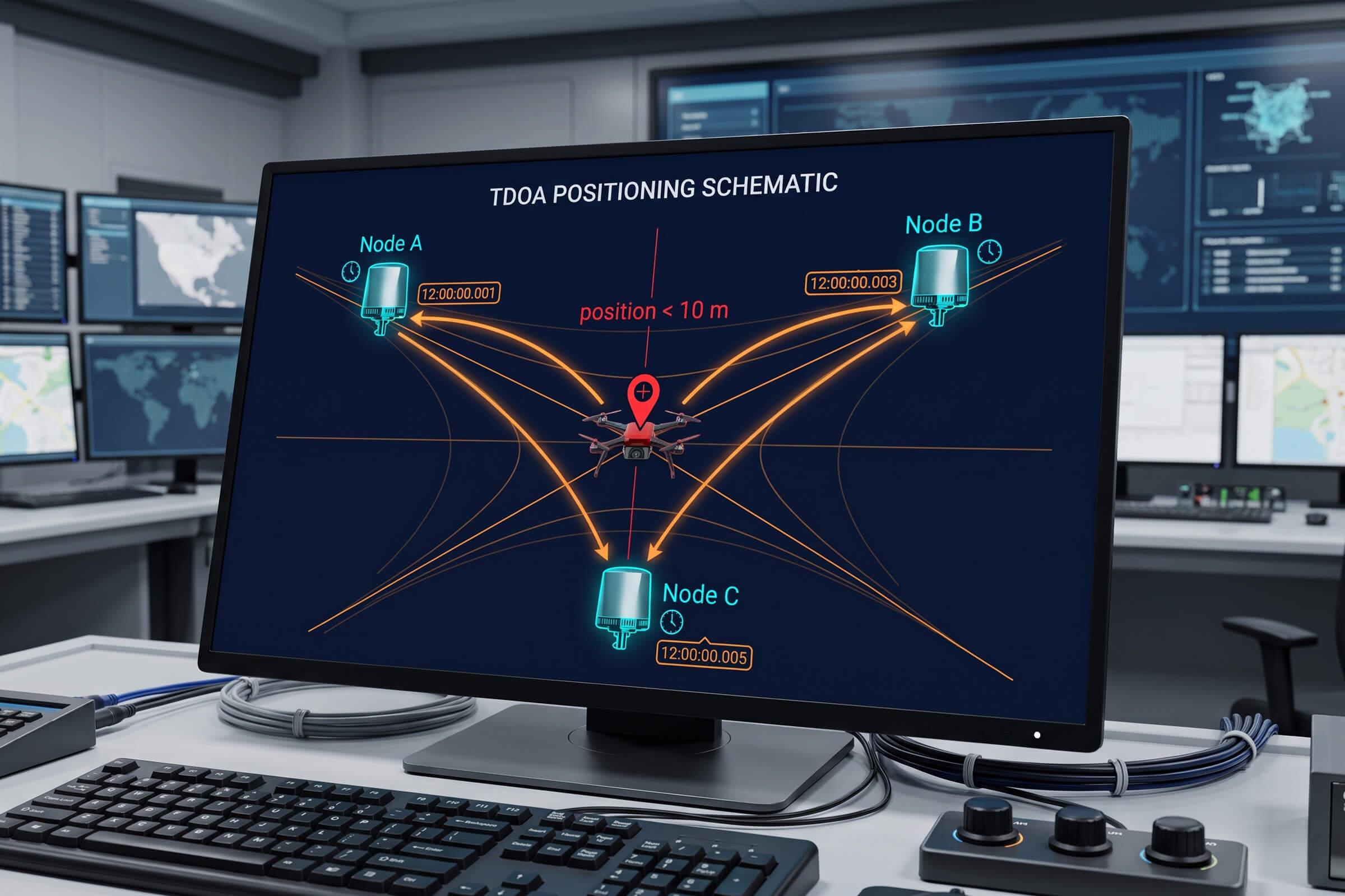
When you network passive sensors along a border, the next question is what each node contributes, and there are two answers. Direction finding measures the angle from which a drone’s signal arrives. Time-difference-of-arrival, or TDOA, measures when that signal reaches different nodes and turns the timing into a position. TDOA is the precise one.
The D5-B is a passive TDOA node built for exactly this role. A single D5-B covers the 30 MHz to 6 GHz band across a full 360 degrees horizontally, detecting a drone out to about three kilometers at altitudes up to one kilometer, and tracking more than thirty drones at once. Its positioning accuracy is better than ten meters RMS, with a response time of about two seconds. At roughly sixty watts and three kilograms, it is small and light enough to be placed where the border needs it and to run there continuously.
The difference between the two techniques matters. Direction finding gives a bearing, and with several units, a rough area. TDOA gives a coordinate. When the question is whether a drone is on your side of the line or the neighbor’s, a coordinate is what settles it, and it is the coordinate that feeds a fast, confident response.
Direction Finding for the First Alert
TDOA is precise, but direction finding is the earlier, wider net. The DF Series units, such as the DFJ83, scan a broad band from 30 MHz to 6 GHz and detect a drone at up to eight kilometers with direction-finding accuracy of three degrees RMS. Deployed along the frontier, they raise the first alert and point the way before the TDOA network has locked a position.
The two techniques are complements, not rivals. Direction finding watches a wide sector and says something is coming from that way. TDOA then places something precisely. Together, they move a border response from a vague warning to a known contact, which is the difference between scrambling to find a drone and already knowing where it is.
Designing the Border Network
The practical design questions for a border network are spacing, redundancy, and handoff. Spacing is driven by the detection range of each node and the terrain it must cover. A node that sees eight kilometers in open country will see less over hills and forests, and the spacing has to shrink to match. The rule is simple: overlap the coverage so that no seam falls between two nodes.
Redundancy means no single node is critical. If one sensor goes down for maintenance or fails, its neighbors extend to cover the sector until it returns. A network designed with overlap tolerates a loss without opening a gap, which is the difference between a system that degrades gracefully and one that fails at the worst moment.
Handoff is what happens when a drone crosses from one node’s sector into another’s. In a network, the track is passed between nodes so the drone stays following the whole way across. A drone that crosses the line is the one case where handoff matters most, because losing it exactly at the frontier is losing it exactly where the answer matters.
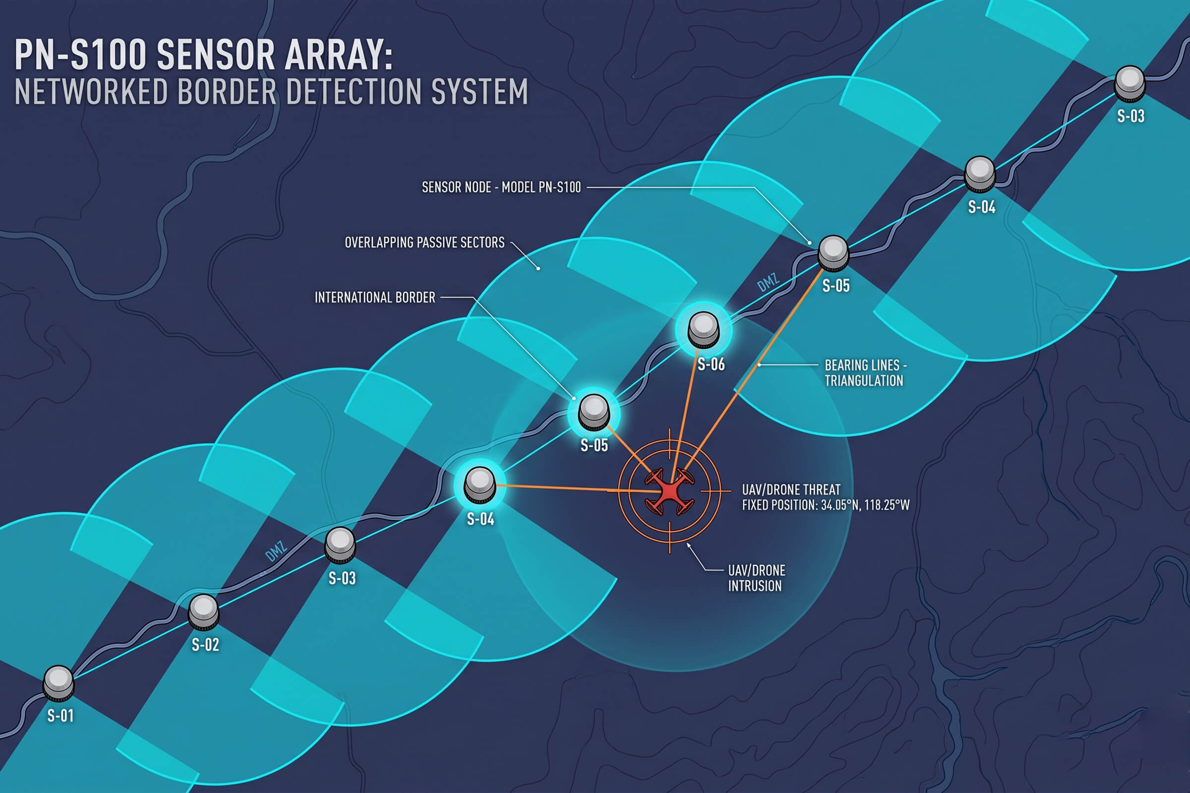
All three constraints point the same way: toward small, passive, low-power nodes that can be placed densely and left to run. That is the physical reality behind the network design, and it is why the border case rewards exactly the kind of system the Black Sea incidents showed was missing.
Then there is power. The points where a border most needs coverage are often the points farthest from the grid. That is the quiet argument for passive, low-power nodes. A sensor drawing tens of watts can run on solar and battery in terrain where a transmitter-heavy design would need a generator and a fuel chain. Off-grid survivability is not a feature on a datasheet. It is what decides whether a node stays online for years or goes dark the first time the fuel runs out.
Weather is the second variable. Rain and fog attenuate radio signals and challenge any optical confirmation layer. A border system cannot count on a clear day. It has to be built around the radio frequency layer first, because that layer works through weather that blinds a camera, and it has to keep working at night when most border crossings happen.
A border network has to survive conditions that a facility network never faces. Mountain passes, dense forest, open plain, and coastal air all change how far a signal carries and where a sensor can be placed. A node that sees eight kilometers on flat ground will see far less through hills, and the design has to account for that by tightening spacing where the terrain closes in.
Terrain, Weather, and the Off-Grid Constraint
The Cross-Border Picture
The Black Sea incidents make a further point. A drone crossing a border is not one country’s problem. It is the shared problem of the country it left, the country it entered, and often the infrastructure near the line. The response is better when the tracks are shared, so that a drone detected on one side is already known to the other before it crosses.
That is why the software layer matters as much as the sensors. A command-and-control platform that fuses the passive nodes, correlates tracks, and presents one picture across the border turns a set of sensors into a shared situation. The hardware sees the drone. The software makes sure everyone who needs to know does so in time to act.
Rapid deployment also closes the gap between an incident and a permanent fix. The first wave of nodes can go in immediately, giving coverage while the full network is designed and funded. Each later phase then extends and hardens what is already watching, rather than starting from zero. That staged approach is how a border gets protected now and better later, which is the only timeline the threat allows.
That is the argument for portable, self-contained nodes. A sensor that is small, light, and low-power can be repositioned by a small team in hours rather than installed by a construction crew over weeks. When the threat moves from one sector to the next, the network moves with it. The border gets a response that tracks the pressure instead of lagging a season behind it.
A border does not wait for a permanent build-out, and neither does the threat. The Black Sea incidents forced an immediate answer, not a multi-year program. Bulgaria moved existing assets toward the affected sector within days, which is the pattern a good border system has to support: a network that can be re-pointed, re-spaced, and reinforced quickly when the pressure shifts.
None of that is satisfied by a bigger single sensor or a more powerful single response. It is satisfied by a network, and by the discipline of building that network from passive, low-power, precisely-positioned nodes that can be placed densely and left to watch. The frontier has already written the requirement. The only remaining question is who builds it.
Taken together, the August events on the Black Sea frontier are a specification in narrative form. They ask for a detection layer that runs continuously and silently, that places a contact precisely enough to know which side of the line it is on, and that can be repositioned when the pressure moves. They ask for a system that survives terrain, weather, and the absence of grid power, and that shares its picture across the border instead of stopping at it.
What the Frontier Asks For
Rapid Deployment for a Moving Frontier
The Bottom Line
A border is where drone detection systems earn their keep, and where weak designs fail first. The sites that get it right treat the border as a network, not a fence. Passive direction finding raises the first alert. TDOA places the contact precisely. A shared command picture makes sure the response crosses the line before the drone does.
The August events on the Black Sea frontier were not a call for a bigger single sensor. They were a call for exactly this: passive, networked, shared low-altitude surveillance that watches the whole line, all the time, without interfering with anything around it.
Connect with us
Ready to Secure Your Low-Altitude Airspace?