Why Belgium’s Drone Violation Wave Rewrites the Rulebook for Event Airspace Security
Jul 17 2026
The Belgian Directorate General of Aviation, DGLV, published a warning ahead of the summer 2026 event season that reads like a checklist of what European counter-drone regulation is about to become. In 2025 alone, Belgian authorities investigated dozens of drone violations. Not isolated hobbyist incidents. Patterned, high-risk offenses concentrated around the country’s highest-profile events.
Rock Werchter. Tomorrowland. The Spa Formula 1 Grand Prix. Each of those venues saw unauthorized drone flights inside active temporary no-fly zones. Two categories stood out in the DGLV report: unlicensed drone light shows operating outside the Specific category permit framework, and individual drones climbing to altitudes of 500 meters, roughly four times the 120-meter ceiling of the Open category. In both cases, the drones were in the airspace before security teams had a verified picture of what they were dealing with.
The Belgian report is not an outlier. It is the data point that confirms a regulatory shift already underway across Europe. France, Germany, the Netherlands, and now Belgium are moving from post-incident fines to preemptive airspace enforcement. Drone light shows without Specific category authorization have been reclassified from a paperwork error to an operational violation. Temporary no-fly zones around major events are now treated as monitored airspace, not advisory airspace. And for the security integrators and venue operators who build the detection stacks that enforce these zones, the hardware implication is unambiguous: detection is not enough. Verification under pressure is the new minimum.
The difference between detecting a drone and knowing what you are looking at
Most counter-drone deployments start with RF or radar for the detection layer. Those technologies answer one question: something is up there. RF detection picks up a signal on a drone frequency. Radar returns a radar cross-section at a range and bearing. Neither one tells you whether that signal belongs to a rogue DJI Mavic or a licensed event drone that drifted 20 meters past its approved flight boundary.
This is exactly the gap that the Belgian violations expose. A drone light show involves a fleet of synchronized aircraft. To an RF detector, a 100-drone light show and a single hostile quadcopter look identical: signals on the same frequency band, from roughly the same azimuth. To a radar, the fleet returns a clustered track that could be anything. The only way to distinguish a coordinated performance from a coordinated incursion is to put eyes on the target. Optical eyes. And that means an EO/IR system that can be guided onto the target fast enough to matter.
The second Belgian scenario, a single drone at 500 meters, pushes the same problem in a different direction. At that altitude, a consumer quadcopter is a speck against the sky or cloud. A security operator with binoculars will not find it before it leaves the airspace. A fixed camera with a wide lens will capture a pixel at best. Visual verification at 500 meters demands optical zoom, thermal sensitivity, and enough edge computing power to lock onto a target before the operator has to make a decision with partial information.
Enter the T100: visual verification built for the moment that matters
The T100 is our team’s three-in-one electro-optical tracking and pointing system. It integrates a visible-light camera, an infrared thermal camera, and a wide-angle camera into a single IP66-rated unit that operates from minus 30 to plus 65 degrees Celsius, around the clock, with 200 TOPS of local edge computing power running multiple deep learning models on-device.
The hardware spec tells one story. The 90x optical zoom with 4K resolution means a DJI Mavic 3 is identifiable at over two kilometers in daylight. The thermal channel, a 640-by-512 vanadium oxide uncooled detector with a 15 mm to 100 mm focal range, pushes identification to one kilometer at night. Medium-sized UAVs push those ranges to four kilometers in daylight and three kilometers after dark. A drone at 500 meters, which is the altitude the Belgian authority flagged as a fourfold Open category breach, is well inside the T100’s identification envelope in both visible and thermal.
But the spec is only half the story. The other half is how the T100 gets onto the target, and what it does once it is locked on. That is where the gaps the Belgian report identified meet the specific engineering decisions our team made when we built the T100’s guidance and tracking pipeline.
Scenario one: the unlicensed drone light show
A 100-drone light show at a major festival looks impressive from the ground. From a detection standpoint, it looks like a problem with a hundred moving parts. The DGLV report highlighted that organizers were running these shows under the Open category, which allows individual drone operation but explicitly excludes coordinated multi-drone flights. The Specific category, which does permit such operations, requires authorization, risk assessment, and an operational safety case. Running a light show without that authorization is no longer a paperwork oversight. It is a violation, and Europe is treating it as one.
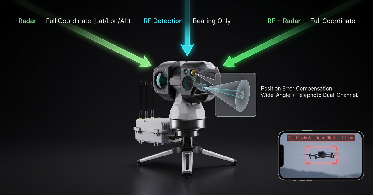
For the venue security team, the operational question is: how do you distinguish an unauthorized light show from a single hostile drone that happens to be flying near clusters of authorized activity? The answer sits in the T100’s multi-source fusion guidance. The system accepts pointing commands from radar systems that provide latitude, longitude, and altitude, and from RF detection systems that provide bearing information. When the detection layer flags multiple contacts in a tight cluster, the T100 slews to the area, activates its wide-angle camera for area search, and then shifts to the telephoto channel the moment a drone enters the field of view.
The 200 TOPS edge computing unit runs classification models on-device. It distinguishes drones from birds, kites, and other airborne objects without sending frames to a cloud server and waiting for a response. This matters at a festival where cellular networks are saturated by 80,000 attendees. Cloud-based AI would choke on the latency. The T100’s models run locally, which means the classification arrives while the target is still in frame.
If the visual feed confirms a coordinated formation with uniform spacing, uniform altitude, and the flight pattern of a preprogrammed light show, the operator sees it, logs it, and escalates through the event’s communication protocol rather than triggering an alarm. If the visual feed shows a single drone breaking formation, changing altitude erratically, or heading toward the crowd, the operator has an entirely different decision to make. The T100 does not make that decision. It makes sure the operator is not making it blind.
Scenario two: the 500-meter drone
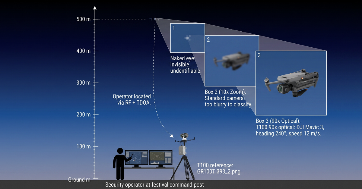
A drone at 500 meters is invisible to the naked eye. It is barely visible to a standard security camera with a fixed wide-angle lens. At that altitude, the acoustic signature is gone. The drone is a silent speck. If the operator has a zoom camera, but it takes 20 seconds to acquire the target, the drone has moved 300 meters at a modest 15 meters per second. The window for visual verification closes before the camera even finishes focusing.
The T100 closes that window with two design choices. First is the active search pattern. When guidance data from radar or RF arrives, the T100 does not simply point at the reported azimuth and wait. It executes a predefined scan pattern, either grid or 3-by-3, with real-time AI detection running on every frame. The wide-angle channel covers a broader sector. The telephoto channel zooms on the first detected target. The moment the AI pipeline detects a drone in any frame of the scan, the system switches from search mode to tracking mode automatically. The operator does not manually slew, zoom, or hunt. The system acquires.
Second is the position error compensation. Guidance data from an RF system carries inherent uncertainty. Signal reflection off buildings, multipath from terrain, and the drone’s own movement during the pointing cycle all contribute to a bearing error that can push the target outside a narrow telephoto field of view. The T100’s wide-angle plus telephoto dual-channel architecture absorbs that error. The wide-angle channel captures the sector that contains the target. The telephoto channel zooms in on the specific contact within that sector. In our own testing, this architecture supports higher position deviations than conventional single-channel EO systems can tolerate. For an operator tracking a 500-meter drone that a bearing-only RF system can only locate to within a few degrees, the error compensation is the difference between acquiring the target and watching it disappear into the cloud.
Why deployment speed matters for temporary no-fly zones
The Belgian violations did not happen at permanent installations. They happened at temporary event no-fly zones. Rock Werchter runs for four days. The Spa Grand Prix runs for three. Each venue has a no-fly zone that exists for less than a week, and the detection equipment arrives, gets set up, and needs to be operational before the first gate opens.
In the conventional EO market, deployment is slow. The unit needs manual compass calibration. The focus needs adjustment to compensate for the temperature difference between storage and the summer field conditions. Integration with the radar or RF system that brought the unit to the event requires a technician to configure communication protocols, coordinate axes, and test handoff sequences. A two-hour setup window before the first crowd arrives is easily consumed by integration debugging between equipment from different manufacturers.
The T100 was designed to invert that timeline. Auto-compass calibration means the unit orients itself after a single initial calibration. No drone flyover. No auxiliary reference hardware. The unit powers on, orients, and is ready to accept guidance data. Integration with radar and RF systems is plug-and-play. Our team built the T100 to work natively with our own counter-drone products, including the D5-Air, D5-B, DF5 MAX, and H3 Pro detection systems. And it integrates directly with third-party radar and RF equipment through standard guidance protocols. The result, measured in our own field deployments, is a setup time of approximately ten minutes from unboxing to operational readiness.
The blind spot nobody talks about: what happens when jamming starts
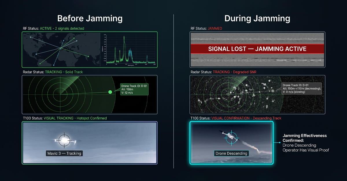
There is an operational reality in counter-drone deployments that most product brochures skip. When jamming activates, RF detection goes silent. The jammer is transmitting across the very bands the detector is listening to. No detection signal. No updated guidance data. And yet, at that exact moment, the security team needs to know one thing more than any other: is the jamming working?
The T100 answers that question optically. When the RF detection layer drops offline because jamming is active, the T100 keeps watching. The thermal channel tracks the drone’s heat signature. The visible channel confirms its visual profile. The tracking algorithm maintains a lock, and the operator sees the target’s behavior in real time. If the drone descends, changes heading, or begins an uncontrolled fall, the operator confirms the jamming is effective. If the drone continues on course, the operator knows the frequency coverage needs adjustment. Either way, the operator has an answer. Without an EO/IR system in the stack, the operator has a blank screen and radio silence that could mean anything.
This is not a theoretical scenario. The DGLV report did not mention jamming because the regulator’s role is to document violations, not to prescribe the neutralization response. But for integrators who design the full detect-to-neutralize chain, the handoff gap between RF and jamming is a known vulnerability. The T100 closes it.
Edge AI: why the model has to run on the device, not in the cloud
The T100 packs 200 TOPS of local computing power. That number matters for three reasons that stack in the event-security context.
First, latency. A camera frame arrives at the processing unit. The AI model detects an object, classifies it, and returns a label before the next frame arrives. This happens at the frame rate of the camera, on the device. No round-trip to a cloud inference server. No 4G congestion at a festival. No intermittent connectivity at a rural venue. The classification pipeline runs regardless of what the cellular network is doing.
Second, model specificity. The T100’s deep learning pipeline distinguishes drones, birds, kites, and other airborne objects. In a field test at 500 meters, a bird circling a thermal and a drone hovering can look nearly identical to a basic motion-detection algorithm. The T100’s models are trained on the features that separate them: motion pattern, aspect ratio over time, thermal signature profile, and wing-flap frequency versus rotor-blade frequency. The edge unit runs multiple models simultaneously. If a specific deployment site introduces a new false-alarm source, our team can retrain the models on site-specific data and update the unit.
Third, what the model output enables is that once the AI pipeline classifies a contact as a drone, the T100’s tracking algorithm locks on. It combines correlation filtering, deep feature tracking, and edge tracking into a fused lock that holds through partial occlusion, background clutter, and rapid changes in the target’s aspect angle. The operator sees a stable track with a bounding box and a classification label, not a jittering crosshair that wanders off target whenever the drone banks.
The regulatory direction: Europe is raising the bar on event airspace
The Belgian DGLV warning is the latest signal in what is now a clear trajectory across Europe. France has been running its own event-season enforcement campaigns, with dedicated drone detection units deployed at major festivals and sporting events. Germany passed updated airspace legislation that gives local authorities the power to impose and enforce temporary no-fly zones with real-time monitoring requirements. The Netherlands is piloting a centralized drone traffic management platform that connects venue-level detection data to a national airspace picture.
Each of these developments adds a requirement to the event security integrator’s checklist. Detection coverage is not enough. The detection layer needs to produce verified identification that can be logged, timestamped, and submitted as evidence if a violation leads to prosecution. A radar track labeled ‘unknown contact’ does not meet that standard. A visual confirmation with a 4K image of the drone, its heading, and its altitude does. The T100, by design, captures and timestamps every detection and track event. The data is exportable for incident reporting, and it is structured to feed into the kind of centralized airspace monitoring platforms that the Netherlands and others are piloting.
Integration: EO/IR that works with what you already have
One of the persistent friction points in counter-drone deployment, and one our team identified in our own market research before we designed the T100, is that EO/IR systems, radar systems, and RF detection systems typically come from different manufacturers. The integrator spends hours, sometimes days, making them talk to each other. Guidance handoffs fail. Coordinate systems do not align. The radar reports a target at 47 degrees, the EO unit interprets that as 49 degrees, and the drone flies through the two-degree gap while the systems argue about calibration.
The T100 was engineered to reduce that friction as close to zero as possible. With LZ TECH’s own products, the integration is native. Connect a D5-Air, D5-B, DF5 MAX, or H3 Pro to the T100, and the guidance handoff works out of the box. With third-party radar and RF equipment, the T100 supports both bearing-only guidance and full-coordinate guidance modes. The unit accepts standard protocol interfaces. Once connected, the commissioning test confirms guidance accuracy, and the system is operational.
For venues that already own RF or radar systems, the T100 adds visual verification without replacing existing investments. Our team has deployed T100 units alongside previously purchased third-party radar at correctional facilities and government sites. The integration is fast because the guidance interface is simple: give the T100 a bearing or a coordinate, and it points, searches, and acquires.
The takeaway from the Belgian summer
The DGLV report is short. Dozens of violations. Dozens of events. Two clear violation categories. A regulator publicly signaling that the Open category is not a loophole for coordinated drone operations and that temporary no-fly zones will be enforced, not advised.
For the integrators and venue operators who build the detection stacks, the report confirms something that has been building for two years: detection alone does not close an airspace. RF tells you a drone is transmitting. Radar tells you something is at a range and bearing. Neither one answers the question that the security controller needs answered: what is it, where is it going, and do I need to act.
An EO/IR system like the T100 answers those questions. It verifies. It classifies. It tracks. It keeps watching when the RF layer goes dark. It deploys in ten minutes on a temporary event site. It feeds verified data into the incident log that a regulator will ask for. And it does all of this with the sensor fusion architecture that separates a counter-drone system from a collection of hardware on separate tripods.
As the European event season heats up and regulators move from warnings to enforcement, the gap between what RF and radar can tell you and what an optical system can confirm is no longer a technical nuance. It is the gap between compliance and a violation report with your venue’s name at the top.
Connect with us
Ready to Secure Your Low-Altitude Airspace?