CCS
The CCS Command and Control System is an intelligent system for comprehensively managing and monitoring drone detection and defense equipment. It enables networked coordination, status monitoring, real-time alerting, and data analysis of multiple defense devices across different regions. The system supports data sharing and communication between different types of equipment, facilitating information sharing and collaborative management for administrators across various regions and levels.
Multi-Sector Networked Management
Create multiple sectors within an organization to achieve grouped management and permission isolation across regions, departments, and clearance levels. Each sector operates independently, and every device belongs to exactly one sector — ideal for large-scale, multi-site deployments.
Real-Time Detection & Threat Assessment
All connected devices feed live detection data into a unified dashboard. The system automatically evaluates threat levels — High, Medium, or Low — and supports multi-dimensional filtering by device, model, drone ID, frequency band, and blacklist/whitelist status.
Multi-Protocol Precision Identification
Integrates CRPC reverse-protocol parsing, DJI DroneID proprietary decoding, and RID remote identity broadcasting to extract deep intelligence: drone model, serial number, position, altitude, speed, heading, and flight status — far beyond simple RF detection.
GNSS Spoofing Countermeasures
Two spoofing modes are available: Evict (redirects the drone away from the defense zone; auto-detects heading or defaults to circling mode) and Forced Landing (commands the drone to land at its current position). A non-kinetic, zero-collateral alternative to jamming.
Unattended Automated Operation
Enable autonomous 24/7 defense with a single toggle. Once activated, the system automatically executes pre-configured countermeasures — wideband jamming, precision jamming, or GNSS spoofing — against any non-whitelisted drone. Supports all-day or custom time periods (up to three slots per day).
Quick Attack One-Click Response
Pre-configure up to three strike strategies (jamming method, whitelist protection, time period). Enabled strategies appear on the main interface — click once to activate, bypassing the need to select individual targets or step through menus. Eliminates response delays in multi-drone emergencies.
Specifications
| ADS-B Integration | Receives civil aviation broadcast data (flight number, position, altitude, speed) to distinguish manned aircraft from drones, reducing false alarms and improving situational awareness. |
| Pilot Positioning | Resolves pilot location from drone signal analysis, displays on map, and supports QR-code scan navigation for rapid field response. |
| Whitelist Management | Import/export (CSV/XLS/XLSX), expiration date configuration, one-click batch distribution to all connected devices. Whitelisted drones are protected during unattended mode. |
| Trajectory Replay | Dynamic playback of historical drone flight paths for post-incident analysis, behavioral pattern assessment, and event review. |
| Multi-Mode Maps | 2D, 3D, satellite, vector, and offline map support. Includes distance measurement, coordinate picking, and map rotation for flexible situational analysis. |
| Map Offset Correction | Auto or manual coordinate correction to align displayed positions with actual ground truth, improving target positioning accuracy. |
| User & Role Management | Three built-in roles (Admin, Operator, Read-Only) with customizable role creation and fine-grained permission assignment across dashboard and admin backend. |
| Remote Firmware Upgrade | Multi-device batch OTA upgrades with real-time progress tracking (percentage per stage) and upgrade history records. |
| Full Audit Logging | System countermeasure logs, device countermeasure logs, and operation logs — all exportable as CSV for compliance and forensic purposes. |
| Multi-Language Interface | One-click language switch for international deployments and multi-national operator teams. |
| Custom Alarm Sounds | Upload WAV-format audio files (up to 2 MB) as custom alert tones. Volume slider with mute/max quick-toggle. |
CCS is an intelligent command and control platform for networked drone detection and counter-UAS management. It enables coordinated multi-sector monitoring, real-time alerting, and automated threat neutralization across distributed defense devices, providing unified situational awareness for security operators at every level.
10 Key Features
- Multi-Sector Networked Management
Create multiple sectors within an organization to achieve grouped management and permission isolation across regions, departments, and clearance levels. Each sector operates independently, and every device belongs to exactly one sector — ideal for large-scale, multi-site deployments.
- Real-Time Detection & Threat Assessment
All connected devices feed live detection data into a unified dashboard. The system automatically evaluates threat levels — High, Medium, or Low — and supports multi-dimensional filtering by device, model, drone ID, frequency band, and blacklist/whitelist status.
- Multi-Protocol Precision Identification
Integrates CRPC reverse-protocol parsing, DJI DroneID proprietary decoding, and RID remote identity broadcasting to extract deep intelligence: drone model, serial number, position, altitude, speed, heading, and flight status — far beyond simple RF detection.
- Precision & Wideband Jamming
Precision Jamming targets a single drone without interfering with other UAVs or surrounding Bluetooth/Wi-Fi signals. Wideband Jamming delivers full-spectrum RF suppression with three selectable strategies — Best Effect, Minimal Interference, and Closest Distance — for rapid multi-target scenarios.
- GNSS Spoofing Countermeasures
Two spoofing modes: Evict (redirects the drone away from the defense zone; auto-detects heading or defaults to circling) and Forced Landing (commands landing at the current position). A non-kinetic, zero-collateral alternative to jamming.
- Layered Air Defense Zones
Draw rectangular, circular, or polygonal defense and early-warning zones on the map. Defense Zone triggers red highest-level alert; Warning Zone triggers orange medium-level alert; outside all zones displays blue with no alarm.
- Unattended Automated Operation
Enable autonomous 24/7 defense with a single toggle. The system automatically executes pre-configured countermeasures — wideband, precision jamming, or GNSS spoofing — against any non-whitelisted drone. Supports all-day or custom time periods (up to three slots).
- Quick Attack One-Click Response
Pre-configure up to three strike strategies. Enabled strategies appear on the main interface — click once to activate, bypassing individual target selection. Eliminates response delays in multi-drone emergencies.
- Task Dispatch & Personnel Coordination
When a pilot position is resolved, the system identifies idle handheld operators within 5 km. Commanders assign tasks with one tap; assignees receive one-click navigation on mobile. Task status syncs in real time across all stations.
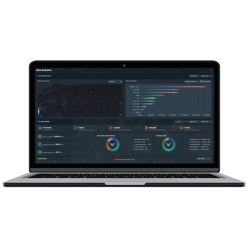
- Analytics & Visual Reporting
Built-in analytics engine generates device event heatmaps, event ranking charts, drone data statistics, and trend analysis (daily/hourly). All data is exportable as CSV for offline archiving, compliance, and forensic analysis.


Product Inquiry
We will contact you within one working day. Please pay attention to your email.
Connect with us
Ready to Secure Your Low-Altitude Airspace?