Radar and Electro-Optical Systems for Drone Detection

Introduction

Most counter-drone articles spend most of their time on radio frequency detection. That’s understandable. RF is versatile, passive, and cost-effective. But if you’ve deployed RF detection at any scale, you already know its limits. Autonomous drones don’t phone home. Modified UAVs use frequencies you’re not monitoring. DIY builds run on custom protocols that never get added to any library. RF sees all of these the same way: nothing.

When RF alone can’t give you the coverage picture you need, you move to active sensing. Radar and electro-optical systems fill the gaps that passive detection leaves open. They won’t replace RF in most architectures, but they change what the architecture is capable of.

This article walks through both technologies, what they do well, what they don’t, and how they fit into a real deployment. If you’re trying to figure out whether active sensing belongs in your counter-drone setup, this is the framework.

Radar for drone detection

How drone detection radar works

Radar works by sending out radio pulses and analyzing what comes back. That’s the basic principle, whether you’re tracking passenger jets or small UAVs. The difference is in the execution.

Standard air traffic radar is built for large metal aircraft. A Boeing 737 has a radar cross-section of roughly 20 to 80 square meters. A DJI Mavic 4 comes in at about 0.02 square meters, smaller than a baseball. Conventional radar filters objects of that size as noise. Counter-drone radar is a different product. It uses higher frequencies, X-band or Ku-band, and advanced signal processing to detect and track drone-sized objects.

Phased-array radar is the architecture most commonly specified for counter-drone work. Instead of a rotating dish, it uses an array of antenna elements that steer the beam electronically. That means faster scanning, more precise control, and no moving parts to fail. It’s also how modern military radar works, which should tell you something about its capability.

The key measurement that separates a useful counter-drone radar from a generic one: what’s the smallest detectable object at what range? A radar that can’t track a 0.02 square meter target at 2 kilometers isn’t solving the problem.

What radar actually gives you

Radar gives you range, bearing, and velocity of anything in its coverage volume. It works in all weather, day or night. It doesn’t care whether the drone is transmitting or flying autonomously. If something is moving through the airspace at drone-like speeds, radar will see it.

What radar doesn’t give you is identification. A radar track says there’s a small, slow airborne object at position X. It doesn’t tell you whether that’s a DJI Matrice, a homebuilt quadcopter, or a large bird. You need a second sensor for that.

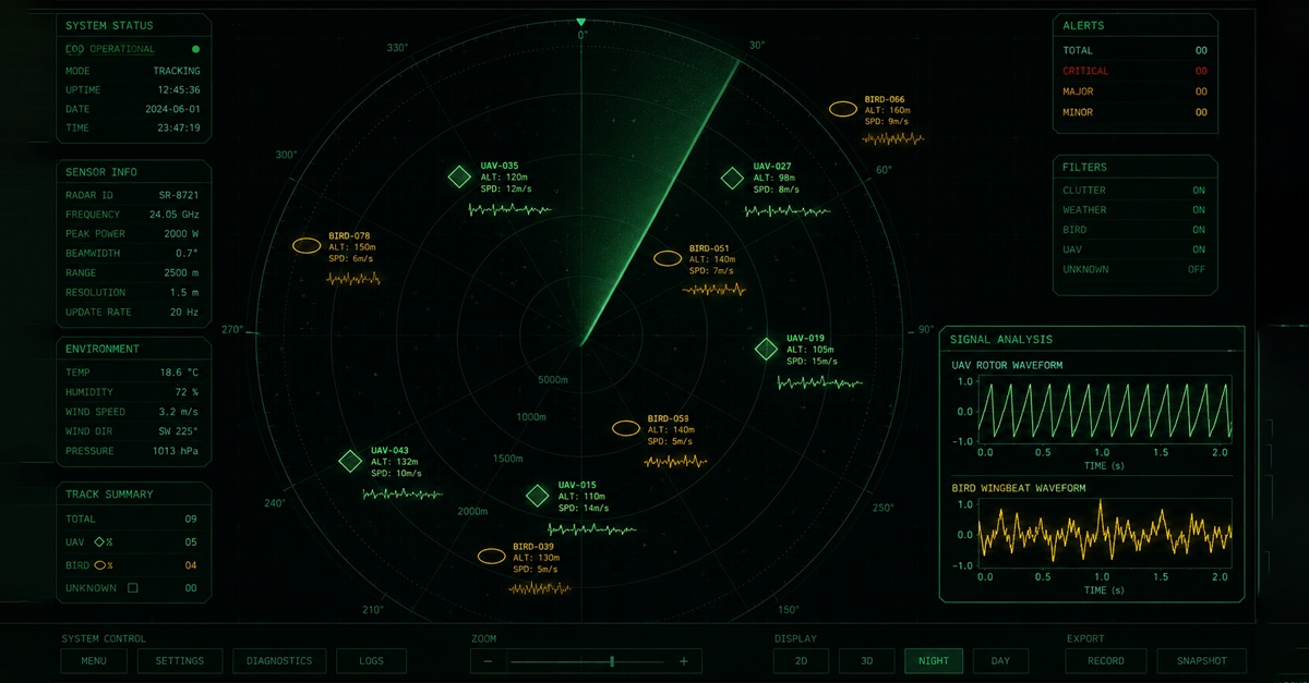
The other constraint is clutter. Urban environments with lots of buildings and moving vehicles generate radar reflections. Without good filtering, your operators end up with thousands of tracks to sort through. This is where signal processing matters: modern counter-drone radar uses micro-Doppler analysis to distinguish the spinning rotor signature of a drone from the return of a truck or a bird.

The bird problem

Every counter-drone operator who has deployed radar near wildlife has a story about the pigeon incident. Birds and small drones produce similar radar signatures. Without good classification processing, a flock crossing your perimeter can generate dozens of tracks that look just like drone incursions.

The micro-Doppler signature is the key differentiator. A drone rotor produces a periodic, high-frequency return that looks like a sawtooth pattern on the Doppler spectrum. A bird’s wingbeat produces something slower and more irregular. Good counter-drone radar can classify these with reasonable accuracy, but it’s not perfect. Hovering drones produce minimal rotor return, and some large birds generate signals that look like small drones.

When you’re evaluating counter-drone radar, ask for the bird classification rate in the vendor’s test data. A 90% classification accuracy sounds solid until you run the math: at a site near a wildlife area with frequent bird crossings, 10% false positives add up fast. That’s hours of operator time spent confirming that the track is not actually a drone.

Most serious deployments handle this by layering: radar handles early detection and rough tracking, and a second sensor confirms what the radar found. We’ll get into that below.

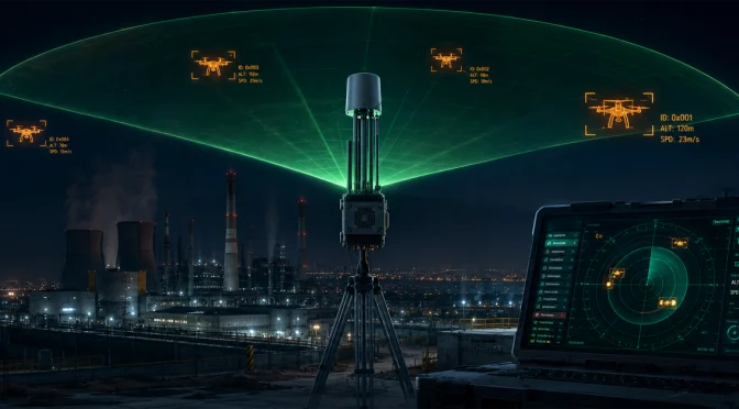
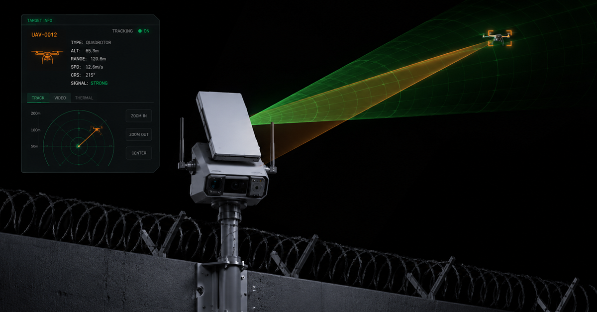
TR100: radar and EO/IR in one package

The TR100 is LZ TECH’s answer to the sensor integration problem. Instead of buying radar from one vendor and cameras from another and figuring out how to make them talk to each other, the TR100 packages phased-array radar, visible-light cameras, thermal imaging, and wide-angle optics in a single unit. Radar detects and tracks the target. The EO/IR payload immediately slews to the bearing and provides visual confirmation.

The workflow is radar-guided. The radar detects something in the coverage volume, classifies it as a potential drone, and points the cameras at it. An operator or AI processing confirms: drone, model, threat level. This is faster than having an operator monitor a raw radar feed and manually cue cameras, which is what happens when sensors come from different vendors and don’t integrate.

Fixed-site deployments that need continuous perimeter coverage are where the TR100 makes most sense. Airports, prisons, power plants, government facilities. The all-in-one form factor simplifies installation and reduces the integration headache. The tradeoff is that you’re buying a complete sensor package whether you use all of it or not. For mobile or tactical applications, a different configuration usually works better.

Electro-optical and infrared systems

What EO/IR actually does

Electro-optical systems are cameras. Visible-light cameras capture what you can see. Infrared cameras capture heat signatures. Thermal imaging reads the infrared radiation emitted by objects, which means it works in the dark, through haze, and in conditions where visible-light cameras struggle.

The use case breaks into two modes: confirmation and primary detection. In most architectures, EO/IR is confirmation. Something else finds the drone. The cameras point at it and confirm: yes, that’s a drone, here’s the model, here’s what it’s doing. In this role, cameras are evidence and identification tools, not primary sensors.

Using optical systems for primary detection is technically possible but practically demanding. You need cameras covering 360 degrees, software that can scan for small moving objects, and enough processing power to handle the output without generating a wall of false alerts. It’s not impossible, but it’s a different engineering problem than mounting a zoom camera on a pan-tilt head and slewing it to a bearing.

Dual-spectrum imaging

Most serious counter-drone cameras combine visible-light and thermal sensors in one housing. Visible-light gives you the detail you need for identification: color, markings, payload indicators. Thermal tells you where to look at night or in fog.

A drone’s motors and electronics generate heat. At night or in low visibility, a thermal camera can pick up a drone at ranges where a visible-light camera sees nothing. The tradeoff is resolution: thermal cameras at the price points realistic for most deployments don’t give you the same identification confidence as optical. You can confirm there’s something there. You might not be able to confirm exactly what it is at maximum range.

For 24-hour coverage, dual-spectrum is the minimum configuration. Single-spectrum thermal works for detection. Single-spectrum optical works for daytime identification. Only dual-spectrum gives you both.

AI-enhanced visual detection

The manual detection problem in optical systems is real. An operator watching a camera feed for drone intrusions will miss things, especially when nothing is happening for long stretches and then multiple things happen at once. AI changes the economics of visual detection by automating the hard part.

Modern systems use computer vision models trained on drone imagery to automatically detect and classify objects in the camera’s field of view. The system flags potential drones without requiring an operator to be watching. It also handles the drone versus bird classification problem, though not perfectly.

The other piece is intelligent gimbal control. Good EO/IR systems don’t just stare at a fixed field of view. They use motion detection and predictive tracking to keep moving targets in frame. Once a drone enters the coverage area, the system tracks it across multiple camera positions if the target moves.

LZ TECH’s VAR300 is positioned around autonomous scanning. The claim is that it can operate without an external cue from radar or RF, using its own AI visual processing to detect and track drones. If that works as described, it changes the deployment model: a site could run VAR300 as a standalone detection layer without integrating other sensor types. Whether that’s the right architecture depends on the threat model and budget.

T100: PTZ tracking and pointing

The T100 is LZ TECH’s long-range PTZ tracking system. The specs that matter: 6.1 millimeter to 561 millimeter focal length. That range covers wide-area surveillance at the short end and precise identification at the long end. Daylight identification range is specified at 2 kilometers or more against a DJI Mavic 3 reference target. Thermal performance at night is specified at 1 kilometer under similar conditions.

The longer focal length is where the T100 earns its position in a deployment. When you need to confirm what a drone is doing at distance, a PTZ with serious zoom is the tool. A guard on patrol with a handheld thermal monocular can confirm there’s something in the air. The T100 can confirm the model, read any visible markings, track the flight path, and record the trajectory for evidence.

Trajectory recording is the forensic piece. A thermal clip of a drone hovering over a restricted area is useful for reporting. A video recording with time-stamped position data and zoom level is useful for prosecution. Different sites have different needs here. Government facilities and airports usually need the evidence chain. Private facilities often don’t.

Why you need both radar and EO/IR

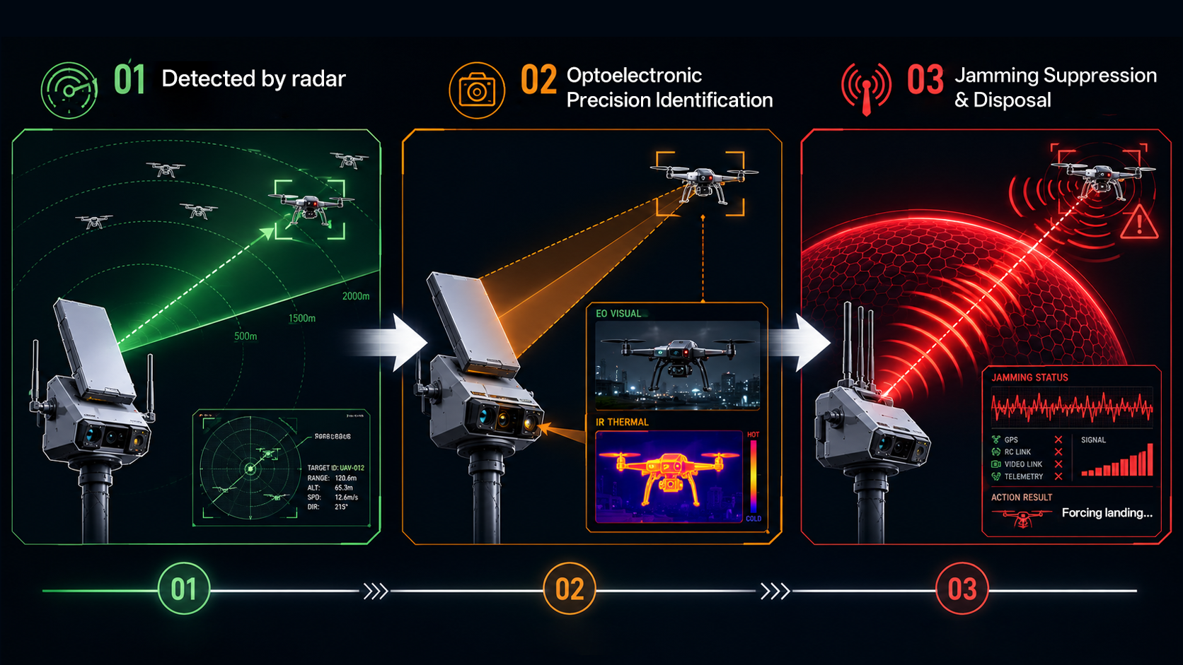
Here’s how a properly integrated radar-EO/IR system works in practice. Something enters the radar coverage volume. The radar detects it, classifies it as a potential drone based on size and movement profile, and calculates the bearing and range. That bearing is passed to the EO/IR system within milliseconds. The cameras slew to the correct heading and zoom level automatically. An operator or AI confirms: drone, model, intent assessment. If response is warranted, the system is already tracking the target with cameras.

Without that integration, you have two separate workflows. The radar operator sees a track and has to manually cue the cameras to that bearing. That takes seconds, during which the target might move. If multiple tracks appear simultaneously, the operator is juggling. Under stress, with adrenaline, during a real incident, that lag matters.

The other reason integration matters: confirmation is not optional for most response decisions. If your response to a drone is jamming its link, you want to be reasonably confident that what you’re jamming is actually a drone and not a bird, a plastic bag, or a weather balloon. Radar alone doesn’t give you that confidence. Cameras do.

LZ TECH’s Multi-tech Fusion Detection Solution is designed around this integration model. Radar and EO/IR are part of the same system, sharing data through the C2 layer. The vendor argument is that buying the pieces separately and integrating them yourself is the expensive and time-consuming path. It’s a reasonable argument for sites that don’t have an engineering team that wants to own the integration.

Choosing the right active sensing configuration

Fixed-site deployments with continuous monitoring needs are the clearest case for integrated radar-EO/IR. Airports, critical infrastructure, government facilities. These sites need 24/7 coverage, fast response times, and a clear evidence chain. The TR100 handles all of that in a single installation.

Sites that already have RF detection and want to add active sensing without a full integrated system can add T100 cameras to an existing setup. The cameras don’t require radar as a cue, though they’ll perform better with it. This is a reasonable upgrade path for sites that deployed RF first and are now expanding coverage.

VAR300 is the autonomous option. If the deployment scenario requires a sensor that can detect and track drones without relying on other systems, VAR300’s standalone AI visual processing is worth evaluating. The tradeoff versus integrated radar-EO/IR is that visual-only detection has a harder time in poor weather and at longer ranges than radar-assisted systems.

The question we keep coming back to is the same one that drives the rest of the counter-drone architecture: what are you actually defending against? Amateur operators near your perimeter don’t need the same sensor configuration as sophisticated actors running modified UAVs with intentional evasion tactics. Match the active sensing investment to the actual threat profile, not to the specifications of the most capable system available.

The bottom line

Radar and EO/IR fill the gaps that passive RF detection leaves open. They handle autonomous drones, provide visual confirmation for response decisions, and give you an evidence chain for anything you decide to act on.

Radar alone is early warning without identification. EO/IR alone is confirmation without the range to find targets on its own. Together, they complete the detection loop that RF starts.

Integrated systems like the TR100 simplify deployment by removing the integration problem. Modular systems like T100 plus existing sensors give you more flexibility if you have the engineering capability to own the integration yourself.

For sites where autonomous drones are a documented threat, where evidence collection matters, or where RF-only coverage has proven insufficient, active sensing belongs in the architecture. The specific configuration depends on the site, the threat model, and the budget.

RF detection vs radar vs optical sensors which counter-drone technology fits your site?

Introduction

A security director at a Middle Eastern airport called us last year with a problem. He’d bought a counter-drone system, radar plus RF detection, plus cameras, and it was generating 200+ alerts per day. His team was exhausted. The system was technically working, but they couldn’t keep up with the noise. By month three, they were ignoring most alerts entirely.

That’s the thing about detection technology. The hard part isn’t buying sensors. It’s matching the sensors to the environment in a way that produces actionable information without drowning your operators.

This article compares the three primary detection technologies, radio frequency (RF), radar, and optical sensors, in terms of how they actually perform in the field. Not spec sheets. Not marketing claims. What happens when you deploy them?

If you’re in procurement and trying to figure out where to invest a limited budget, this is the framework we wish someone had given us.

Radio frequency detection

How it works

RF detection listens for the signals drones use to communicate with their controllers. Every commercial drone, DJI, Autel, Parrot, and the various Chinese OEMs, transmits on known bands: primarily 2.4 GHz and 5.8 GHz, sometimes 900 MHz or 1.2 GHz for longer-range links.

An RF system consists of one or more antennas plus processing hardware that monitors these bands. When it detects a signal matching known drone signatures, it can identify the model and sometimes extract a unique identifier, similar to a MAC address.

The detection range depends on antenna gain, processing sensitivity, and environmental conditions. In practice, most RF systems detect commercial drones at 2-5 km under favorable conditions. Urban environments with high RF noise reduce that range.

What RF actually detects

Here’s the constraint that matters most: RF only detects drones that are transmitting. If a drone is flying autonomously, following pre-programmed waypoints with no active link to a controller, RF sees nothing. If a drone is using a frequency you’re not monitoring, RF sees nothing. If a drone has been modified to use encrypted or proprietary links, RF probably sees nothing.

This isn’t a minor gap. The UK Ministry of Defence estimated in a 2023 briefing that roughly 15-20% of drone incursions at sensitive sites involved autonomous flight. That number is climbing as cheap flight controllers with GPS waypoint capabilities become widely available.

RF detection is strongest against amateur operators, people flying DJI consumer drones near your perimeter, because they don’t know better. It’s weakest against anyone who knows you’re listening.

The library problem

RF systems work by matching detected signals against a library of known signatures. That library needs constant updating. Every time a manufacturer changes a protocol, DJI updates the OcuSync firmware, Autel releases a new transmission standard, the vendor has to reverse-engineer it and push an update to customers.

Between updates, modified drones pass through undetected. The lag isn’t theoretical. After DJI released the Mini 3 Pro with an updated transmission protocol in 2022, several counter-drone vendors took 4-6 months to fully integrate the new signatures. During that window, those drones flew through coverage.

LZ TECH’s approach, CRPC or Cognitive Radio Protocol Cracking, attempts to address this by reconstructing protocols rather than matching against libraries. The claim is that this works against DIY and modified drones. We haven’t independently verified the full scope, but the technical direction addresses a real gap in conventional RF detection.

Deployment considerations

RF detection is typically the most accessible entry point for counter-drone capability. Handheld detectors can be carried on patrol. Fixed-site RF systems with multi-antenna arrays and controller triangulation scale to cover larger perimeters depending on coverage area and processing capability.

Installation is relatively simple. You mount antennas with clear line-of-sight to your perimeter, run cables to processing hardware, and connect to your monitoring network. No transmission license required. RF detection is passive.

For sites where a single sensor is all the budget allows, RF is the usual starting point. Just understand what you’re getting: a system that detects most commercial drones flown by people who aren’t trying hard to evade you.

Radar

How it works

Radar sends out radio pulses and measures the return. By analyzing the reflected signal, it can determine direction, distance, and velocity of objects in its coverage area.

Standard air traffic radar is built for large, metal aircraft. A typical passenger jet has a radar cross-section of 10-100 square meters. A DJI Mavic 4 has a cross-section of roughly 0.02 square meters, smaller than a baseball. Conventional radar filters objects this small as noise.

Counter-drone radar is different. It’s optimized for small, slow targets, often using higher frequencies (X-band or Ku-band) and advanced processing to detect drone-sized objects. Micro-Doppler processing analyzes the frequency shift from spinning rotors, helping distinguish drones from birds.

Detection range and coverage

A well-specified counter-drone radar detects small UAVs at 3-10 km, depending on the radar design and environmental factors. Unlike RF, radar doesn’t depend on the drone transmitting. It sees anything with mass and velocity in its coverage volume.

The coverage geometry matters. A 2D radar provides azimuth and range but not elevation. You know something is at bearing 270 degrees and 2 km out, but not how high. A 3D radar adds elevation, giving you full position. For sites where altitude matters, airports, for example, 3D is worth the premium.

The thing radar doesn’t give you: identification. A radar track says ‘small, slow airborne object at position X, Y, Z.’ It doesn’t tell you whether that’s a DJI Matrice, a homemade quadcopter, or a large bird. You need a second sensor, usually optical, to confirm what the radar found.

The bird problem

Birds and small drones have similar radar signatures. A flock of pigeons can generate dozens of tracks. Without good classification processing, your operators get alerts every time birds cross your perimeter.

Modern counter-drone radar uses micro-Doppler analysis to differentiate. The rotor signature of a drone creates a different frequency pattern than bird wingbeats. It’s not perfect. A hovering drone has a minimal micro-Doppler signature, and large birds can be misclassified. But it reduces false positives significantly compared to unprocessed radar.

If you’re evaluating radar, ask for the bird classification rate in the vendor’s test data. A 90% classification accuracy sounds good until you realize that 10% of bird tracks still generate alerts. At a site near a wildlife area, that adds up.

Deployment considerations

Radar represents a larger investment than RF. Installation requires a clear line of sight, a stable mounting platform, and power. Most radar also requires a transmission license, which adds regulatory overhead in some jurisdictions.

For fixed sites with a real budget, airports, power plants, and military installations, radar is worth it. The ability to detect autonomous drones, see beyond line of sight, and track multiple targets simultaneously justifies the investment if the threat model includes coordinated or evasive incursions.

For smaller budgets or mobile applications, radar may be more capabilities than the site requires. A sports stadium that hosts 20 events per year probably doesn’t need a full radar installation. An air base that operates 24/7/365 absolutely does.

Optical sensors (EO/IR)

How they work

Optical sensors use cameras, visible light, infrared, and thermal to detect and identify drones. Electro-optical (EO) cameras capture visible light. Infrared (IR) cameras capture heat signatures. Together, they provide positive identification: you can see the drone, confirm the model, and potentially identify any payload.

The limitation is the detection range and the field of view. A high-resolution zoom camera can identify a drone at 2-3 km, but only if it’s pointed in the correct direction. The narrower the field of view, the longer the range, and the smaller the area you’re actually monitoring.

Detection vs confirmation

Here’s where optical sensors fit in most architectures: they’re confirmation, not primary detection. A radar or RF system alerts on a potential drone at a specific location. The optical system slews to that bearing and zooms in. A human operator or AI processing confirms: yes, that’s a drone, and here’s the model.

Using optical sensors for primary detection is technically possible but practically difficult. You’d need multiple cameras covering 360 degrees, and you’d need software capable of scanning for small, fast-moving targets. The processing load is significant, and the false-alarm rate is higher than that of radar.

LZ TECH’s VAR300 is positioned as active optical detection, a system that scans for drones without needing an external cue. The technology exists. Whether it’s the right fit compared to radar-plus-optical depends on your threat model and budget.

Night and weather performance

Visible-light cameras work poorly at night. Thermal cameras work better; a drone’s motors and battery generate heat, but resolution is lower, and range drops. Fog, haze, and precipitation degrade both.

For 24-hour coverage, you need thermal as well as optical. That increases system complexity. A thermal camera with the resolution to identify drone models at a distance requires a significant investment. Add visible-light capability and a gimbal mount, and the per-position setup becomes one of the more expensive elements in a layered architecture.

The forensic value

Optical sensors provide something radar and RF can’t: evidence. A video recording of a drone crossing your perimeter is usable in prosecution in a way that a radar track isn’t. If you’re in a jurisdiction where legal action against drone operators is realistic, optical coverage matters for more than detection.

The LZ TECH T100 is the PTZ tracker designed for exactly this. 6.1 mm to 561 mm focal length range. Auto-tracking once a target is identified. Recording as evidence for after-action review.

Side-by-side comparison

Factor RF Detection Radar Optical
Detection Range 2-5 km 3-10 km 0.5-3 km
Autonomous Drones No Yes Yes (with cueing)
Identification Model + Serial None (track only) Visual confirmation
Weather Independence High High Low
Regulatory Burden None (passive) Transmission license None

How to choose for your site

Start with your threat model

Every procurement decision starts with the same question: what are you actually defending against? The answer drives everything else.

If your primary threat is amateur operators, tourists flying DJI near your perimeter, hobbyists who don’t know better, RF detection is probably sufficient. These operators use stock equipment, transmit continuously, and aren’t trying to evade you. A well-specified RF system plus training gives you solid coverage.

If your threat model includes sophisticated operators, people who know you have counter-drone capability and are trying to get past it, you need more. Autonomous flight, modified protocols, and deliberate evasion all degrade RF effectiveness. Radar becomes necessary.

If your site has legal exposure, meaning prosecuting drone operators is realistic and useful, optical coverage matters for evidence collection. If prosecution isn’t on the table, optical is lower priority.

Layer for what matters

Most sites end up with layered coverage. RF as the primary detection layer. Radar to catch autonomous drones. Optical for confirmation and evidence. The question isn’t which single sensor to buy. It’s how much coverage you can afford and where to prioritize.

For fixed sites with real budgets: start with RF, add radar, confirm with optical. That’s the standard architecture, and it works for most threat models.

For limited budgets: RF first. Add radar if autonomous drones are a documented concern. Add optical if legal action against operators is realistic.

For mobile or temporary coverage: handheld RF detectors plus a portable camera system. The LZ TECH H3 Pro plus T100 gives you detection and confirmation in a package that fits in a vehicle.

The integration challenge

Buying sensors is easy. Making them work together isn’t. Each sensor generates alerts. Each alert needs to be correlated with alerts from other sensors. A drone that appears on radar at bearing 270 degrees and 2 km needs to match with the RF detection of a DJI Mavic at the same position, and the optical track that confirms the model.

That correlation happens in C2 software. If your C2 system can’t fuse the data, your operators are manually matching tracks. They’ll miss things under stress.

Before you buy sensors, evaluate the C2 layer. Can it ingest data from multiple vendor types? Does it support standard protocols like SAPIENT? Does it correlate tracks automatically, or does it just display three different alert streams?

The best sensor architecture in the world is useless if your C2 layer can’t make sense of the output.

A real example: airport perimeter protection

Let’s walk through how this works in practice. Say you’re protecting a regional airport, maybe 20 commercial flights per day plus general aviation. The budget is limited. You can’t afford a military-grade installation.

Your threat model: mostly amateur operators flying consumer drones near the approach path, with occasional sophisticated incursions that need detection and response.

Here’s how we’d spec it, starting from scratch.

Layer 1, RF detection. Fixed-site RF system covering the approach paths. 2-3 antenna positions with a clear line of sight. This catches 80-90% of your likely incursions, the hobbyists and tourists.

Layer 2, Radar. Single 3D radar positioned to cover the primary approach corridor. This catches autonomous flights and anything using modified protocols.

Layer 3, Optical. Two PTZ camera positions, one at each runway end. These confirm tracks and provide evidence for prosecution.

Start with RF and add layers as incidents prove the need. The architecture supports expansion.

What you don’t do: buy a single radar and expect it to solve everything. Or buy RF and get surprised when autonomous drones fly through. The threat model dictates the architecture, not the other way around.

The bottom line

RF detection is the entry point. It’s cost-effective, easy to deploy, and catches most amateur incursions. It doesn’t catch autonomous drones or sophisticated operators who know you’re listening.

Radar is for sites with real threat exposure. It sees everything in its coverage volume: autonomous, modified, or deliberately evasive. It requires a larger investment and regulatory approval, but it closes the biggest gap in RF-only coverage.

Optical is confirmation and evidence. It tells you what you’re looking at and records it for later use. It’s not primary detection, range and field of view are too limited, but it’s essential for prosecution and forensics.

The right answer is almost always layered. Start with RF, add radar when your threat model demands it, and overlay optical for confirmation. Match the technology to the actual threat, not to marketing claims about capabilities you’ll never use.

And evaluate the C2 layer as carefully as you evaluate sensors. A good integration layer with modest sensors outperforms great sensors with a C2 system that can’t correlate the data.

LZ TECH Ships Counter-UAS Systems in Latest Large-Scale Delivery

LZ TECH Newsroom  |  June 2026


LZ TECH has shipped another batch of counter-UAS systems to international customers. The delivery covers multiple product series including RF detection, jamming, and integrated defense solutions. All units passed reliability and performance testing before leaving the factory.

Built for scale, tested for reliability

The company runs a 10,000m²+ manufacturing and service facility in Luoyang, China, with over 100 staff focused on production, testing, and customer service. That capacity is what allows LZ TECH to handle urgent and high-volume orders from government and enterprise customers in different time zones simultaneously.

Every device in this shipment went through four checkpoints:

  1. Burn-in testing. Units ran under sustained load to verify long-term stability.
  2. RF calibration. Signal integrity and output consistency checked against spec.
  3. Functional testing. Full hardware and software checkout from end to end.
  4. Final inspection and export packaging. Visual inspection, secure packing, documentation for international customs.

Where these systems are going

LZ TECH now has customers in over 60 countries and works with more than 6,000 partners worldwide. This shipment was bound for existing customers who had previously deployed smaller LZ TECH systems and were expanding their coverage.

What the after-sales team says

“Reliable delivery is not only about manufacturing capacity. It is about making sure every system works when the operator turns it on,” said a member of the LZ TECH after-sales team. “From the production line to the shipping container, we are checking consistency at every step.”

Demand for counter-UAS equipment has been climbing across airports, government facilities, power plants, and public safety agencies. LZ TECH is expanding factory automation and adding to its global support network to keep delivery times short as order volume grows.

About LZ TECH

LZ TECH makes counter-UAS and low-altitude security systems. Products include RF detection, jamming, integrated defense solutions, and command-and-control software, sold to government and enterprise customers worldwide.