Category Archives: Blog

Directional vs Omnidirectional Drone Jamming: Why Precision Matters

The Hidden Cost of Omnidirectional Jamming

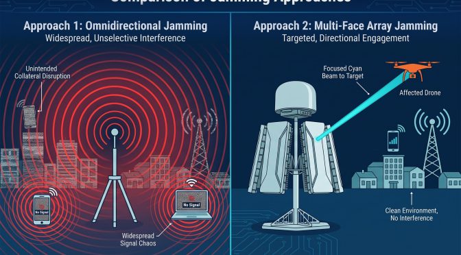
When a drone threatens a protected site, the instinct is to transmit broadly and overpower it. That is what omnidirectional jamming does. It blankets the area with an interfering signal, aiming to disrupt the drone’s control link wherever it happens to be. It is simple, and it works, up to a point. The problem is what it takes down with it.

Omnidirectional interference does not discriminate between a hostile drone and every other radio device in range. At an airport, that means ground communications, navigation aids, and the wireless systems the operation depends on. In a city, it means the networks, sensors, and devices that surround the protected site. A broad jamming response can protect one asset while disrupting the environment it sits in, which is often worse than the drone it was meant to stop.

There is also a practical limit. Omnidirectional energy spreads in all directions, so its strength at any single point is diluted. To reach a drone at a distance, the system has to push more power, which enlarges the collateral footprint further. It is a self-defeating loop: the more it reaches, the more it disrupts.

The Case for Directional Intervention

Directional jamming takes the opposite approach. Instead of broadcasting in every direction, it concentrates the interfering signal into a narrow beam aimed at the drone. The effect is twofold. The beam reaches farther with less total energy because the energy is not wasted on empty space. And the interference stays contained because it only affects the narrow cone where the drone is.

For electromagnetic-sensitive environments, this is the difference that matters. A directional system can intervene against a drone while leaving the surrounding spectrum largely untouched. The ground crews keep their radios. The navigation systems keep working. The neighboring businesses never notice. Precision is not a luxury in these settings. It is the requirement that makes intervention possible at all.
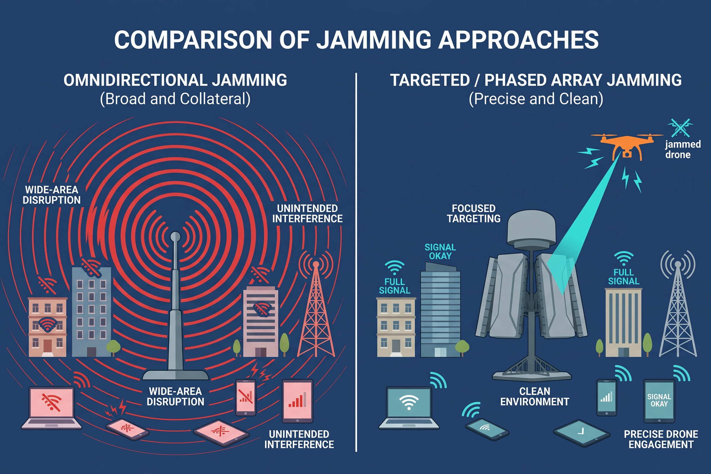
The trade-off has always been coverage. A single directional beam can only point one way, which creates blind spots elsewhere. A drone approaching from behind or from the side is outside the beam and outside the protection. That limitation is what has kept directional systems from replacing omnidirectional ones in fixed-site defense until the array approach arrived.

DFJ53 Max: 360-Degree Coverage Without Blind Spots

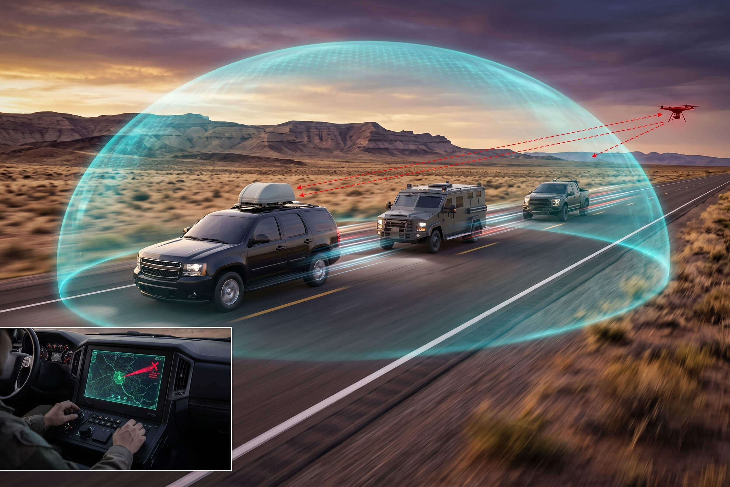
The DFJ53 Max resolves the coverage problem with a multi-face high-gain array and adaptive beamforming. Instead of one antenna pointing one way, it uses an arrangement of high-gain faces that together cover the full 360 degrees around the site. Adaptive beamforming steers the interference energy toward the detected drone, no matter from which direction it approaches.

The result is the best of both approaches. The system keeps the precision and containment of directional jamming because the energy is still focused into a beam. But it eliminates the blind spots because that beam can be formed and steered in any direction, continuously, across the full circle. A drone does not find a gap in the coverage. It finds a beam waiting for it from whatever direction it comes.

The DFJ53 Max monitors a broad radio frequency range, spanning from 400 MHz to 6 GHz, which covers the command and video links used by the large majority of commercial drones. Detection extends across a wide area, with the system able to sense a drone at up to 5 kilometers and intervene at closer range with focused, directional energy. The combination of wide-band detection and full-circle directional intervention is what makes it suited to fixed-site protection in sensitive locations.

For the operator, all of this is invisible. The system handles detection, beam steering, and tracking automatically. The operator sees the contact, sees the intervention, and does not need to manually aim anything. That is the practical payoff of the array approach: precision and coverage, without requiring a human to manage either one in real time.

The multi-face design of the DFJ53 Max applies this across the full circle. Where a single face would leave the sides and rear uncovered, the multi-face arrangement ensures that every direction is covered by at least one array face. The system forms and steers the beam continuously, so a drone approaching from any heading meets a focused, directed response rather than an empty gap.

This is a fundamental difference from a mechanically steered antenna. A dish or a horn has to rotate to aim, which takes time and creates gaps during the movement. An array with electronic beamforming changes direction in microseconds, tracking a moving drone as it crosses the sky. There is no rotation lag and no moment when the beam is pointing the wrong way.
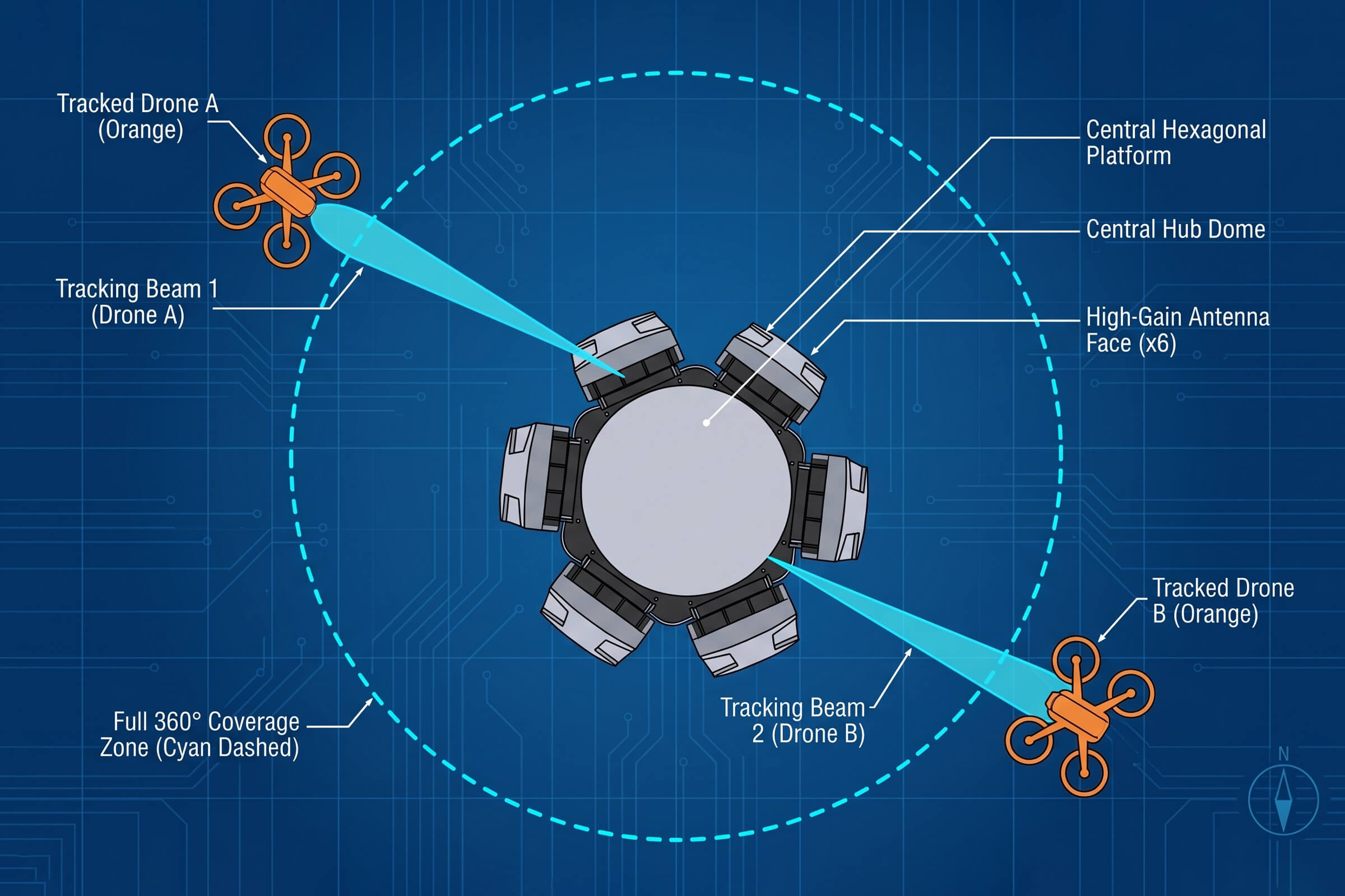
The technology that makes full-circle directional coverage possible is adaptive beamforming. The idea is straightforward, even if the implementation is not. An array of antennas works together as a single, steerable system. By adjusting the timing and phase of the signal at each antenna element, the array can concentrate its output into a narrow beam and point that beam anywhere, instantly, without physically moving anything.

How Adaptive Beamforming Works

Why Cities and Airports Need Precision

The environments where drone defense matters most are also the environments where broad interference is least acceptable. Airports sit inside a dense web of radio systems, from air traffic control to ground operations to passenger networks. A city center is saturated with wireless signals from thousands of devices. In both cases, an omnidirectional response would be disruptive to the very operation it is meant to protect.

A directional array changes the calculus. It lets a security team intervene against a specific drone without taking down the spectrum around it. For an airport, that means the operation can continue while the threat is handled. For a city venue, it means the event goes on, and the surrounding neighborhood is unaffected. Precision intervention is not just a technical preference. It is what makes drone defense deployable in the places that need it most.

This is also a regulatory consideration. In many jurisdictions, the legal space for drone countermeasures is tighter in populated areas, where the risk of collateral interference is treated seriously. A system that demonstrates contained, directional intervention is more likely to be acceptable where a broad, indiscriminate jamming response would not be. Precision is how drone defense earns the right to operate in sensitive places.

The split matters for procurement too. A site that buys only a fixed system leaves its mobile teams uncovered. A team that relies only on handheld units has no persistent watch over the site. The complete answer combines both: fixed arrays for the perimeter, handheld units for the response. Each covers the situations the other cannot reach.

This is why the fixed and mobile layers complement rather than compete. The fixed system, like the DFJ53 Max, holds continuous coverage over a defined site, watching around the clock with full-circle directional precision. The mobile layer, like the HDJ 3.0, gives a responder the ability to detect, localize, and address a drone in the field, wherever the situation happens to be.

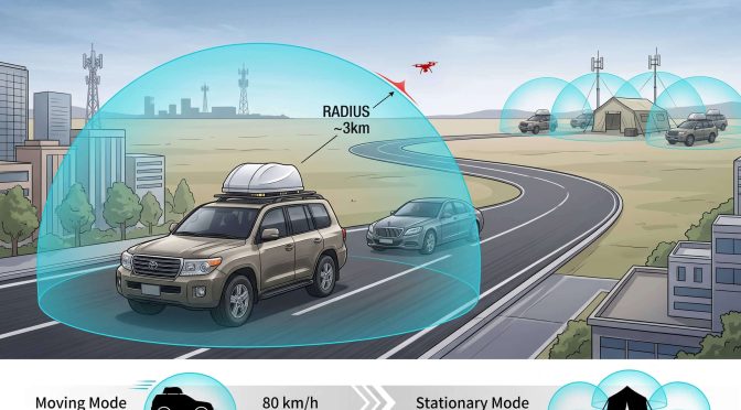
A fixed directional array is the right answer for a site that needs persistent protection, but many drone incidents do not happen at a single fixed location. A VIP motorcade moves through a city. A patrol team responds to a report. A temporary event appears and disappears over a weekend. These situations need capability that moves with the team, not capability that is bolted to a mast.

The Fixed and Mobile Split

Handheld Support: HDJ 3.0

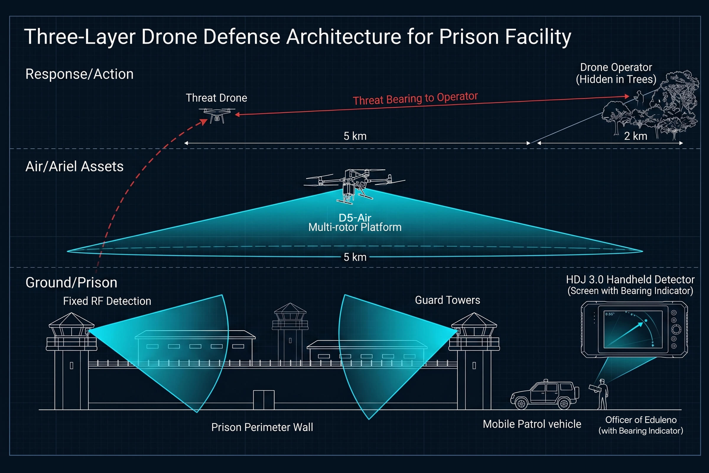
Fixed directional arrays are not the only tool in the kit. For mobile teams, patrols, and on-the-move response, the HDJ 3.0 brings detection and intervention into a handheld unit. It detects across the 400 MHz to 6 GHz range and provides direction-finding to localize the drone, with a direction-finding accuracy of about 10 degrees RMS or better.

Built for field use, the HDJ 3.0 runs on dual hot-swappable batteries for extended operation, delivers several hours of runtime, and presents the picture on a compact screen. It is the complement to a fixed system: the fixed array holds continuous, wide-area coverage, while the handheld unit lets a responder move to the contact and address it up close. Together they cover both the persistent and the on-demand sides of drone defense.

The second question is coverage. Directional precision is only worth having if it does not leave holes. A single steerable beam, however precise, is a liability if a drone can simply approach from behind it. The array approach answers that objection by combining the containment of a beam with the completeness of a full circle. That is the specific problem the DFJ53 Max was built to solve, and it is the reason the old trade-off between precision and coverage no longer has to be made.
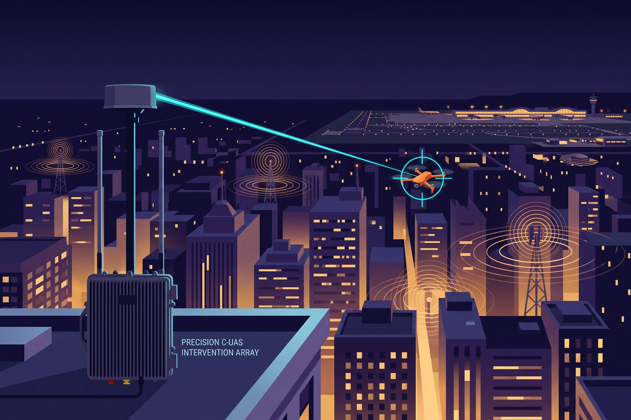
A word on how to think about the choice. The decision between directional and omnidirectional intervention should not be made on power alone. It should be made in the environment. Ask what else shares the spectrum around the protected site. If the answer is nothing, in a remote and isolated location, broad coverage may be acceptable and simple. If the answer is an airport, a city, a power grid, or a communications network, then precision is not optional. It is the only approach that does not trade one problem for another.

The Bottom Line

The choice between omnidirectional and directional jamming is not a choice between strength and weakness. It is a choice between a blunt instrument and a precise one, and the setting decides which is acceptable. In open, isolated terrain, broad coverage has its place. In cities, airports, and other electromagnetic-sensitive environments, precision is the only workable answer.

The DFJ53 Max removes the historical trade-off by pairing the precision of a directional beam with the coverage of a full-circle array. For a fixed site that cannot afford to disrupt its own spectrum while it stops a drone, that combination is the difference between a response that works and a response that works without collateral damage. And that, in the places that matter most, is the whole point.

The Last Kilometer of Drone Defense: From Detection to Visual Proof

Detection Is Not Identification

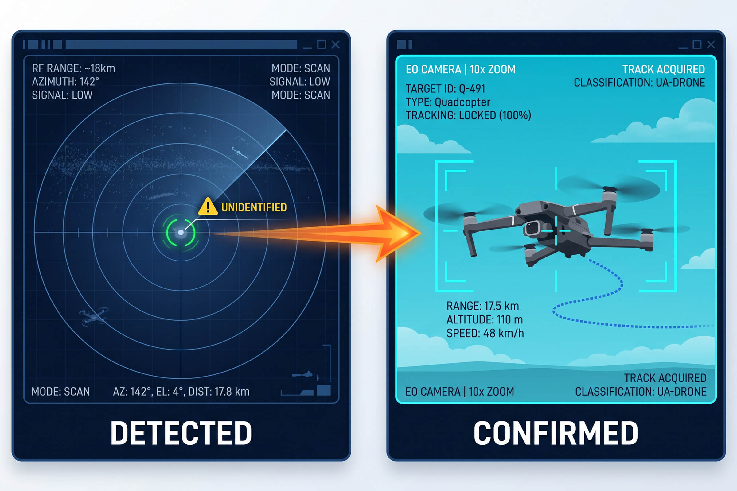
Most drone defense conversations stop at detection. A radio frequency sensor picks up a drone’s signal. A radar unit paints a moving contact. An operator sees a blip on a screen and assumes the job is done. It is not. Detection answers one question, and only one: is something out there? The questions that follow, what it is, where exactly it is, and whether we prove it, are left unanswered.

The gap between a detected blip and a confirmed, documented drone is where most systems quietly fail. A blip cannot be reported to an authority. A blip cannot justify interrupting an event or closing a runway. A blip cannot stand up in an investigation. What turns a blip into something useful is the ability to see the drone, track it, and record what it is doing. That is the last kilometer of drone defense, and it is where electro-optical and infrared tracking earns its place.

Why Seeing the Drone Matters

Three practical reasons make visual confirmation the difference between a sensor and a defense system.

First, false alarms. RF and radar contacts near a busy site are frequently not drones. They are birds, weather returns, legitimate radio traffic, or commercial aircraft passing overhead. Without a visual, the operator cannot tell the difference. Every false alarm that reaches a human desk erodes confidence in the system. Over time, operators learn to ignore the alert that cries wolf, which is the worst possible outcome. Visual confirmation filters the noise before it reaches a decision.

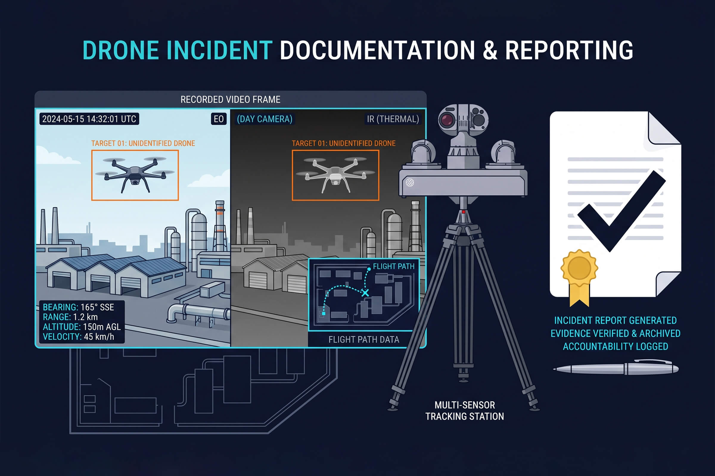
Second, evidence. When an incident happens, such as a drone flying where it should not, dropping a payload, or interrupting operations, the response does not end when the drone leaves. There is a report to write, an investigation to run, and often a legal process to support. An RF log that says a drone was present is weak evidence. A video clip that shows the drone, its flight path, and its behavior is strong evidence. One holds up under scrutiny. The other does not.

Third, the response itself. Knowing a drone is present is not enough to act. The operator needs to know exactly where it is and where it is heading, in real time, to cue any response. A visual tracker provides continuous position. It turns a point-in-time alert into a live track that can be followed, assessed, and acted on.

What an EO/IR Tracker Adds

Electro-optical and infrared systems add exactly the layer that RF and radar lack: a live, visual track of the target. Two capabilities define how well that layer works: how far it can see and how intelligently it can follow.

VAR300: Autonomous AI Scanning

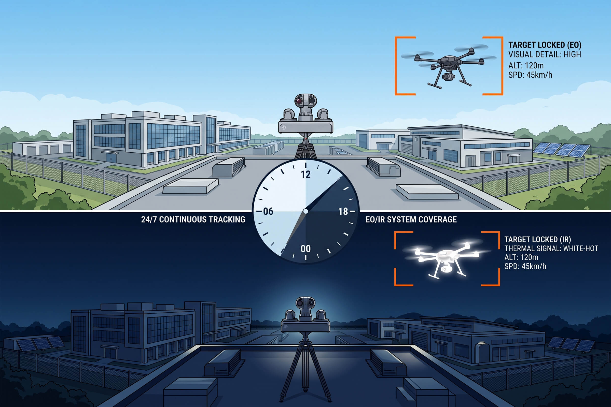
The VAR300 is an all-weather electro-optical and infrared tracker built for continuous surveillance duty. It pairs a 640 by 512 infrared sensor with AI-driven visual tracking to detect and follow drones day and night. During daylight, it detects a drone at up to 1 kilometer and tracks it beyond 1.5 kilometers. At night, the infrared channel takes over, detecting out to roughly 0.5 kilometers and tracking to about 0.8 kilometers. It runs around the clock.

What sets the VAR300 apart is that the tracking is automated. The AI does the watching, so the system does not depend on an operator staring at a screen for the entire shift. It locks onto a moving contact, holds the track, and keeps the camera on the drone as it moves. That autonomy is what makes continuous visual coverage practical, because the human does not have to be the one doing the tracking.

T100: Multi-Source Fusion

The T100 takes the same idea further by fusing radar and radio frequency sensing with dual-spectrum imaging. It combines a visible-light channel with high-definition and high-magnification optics alongside thermal imaging, so it can maintain a visual track at greater range and in more conditions than a single-spectrum tracker. Its multi-source design means the radar or RF layer cues the camera, and the camera confirms what the radar saw.

Onboard edge processing, on the order of hundreds of tera-operations per second, runs the fusion and tracking locally. The result is a system that holds a day-and-night track at ranges reaching several kilometers, without needing to stream everything back to a central server to make sense of it. For sites that need long-range confirmation, the T100 is the answer to the question of what to do when the drone is too far away for a short-range tracker to see.

Closing the Loop: From Alert to Evidence

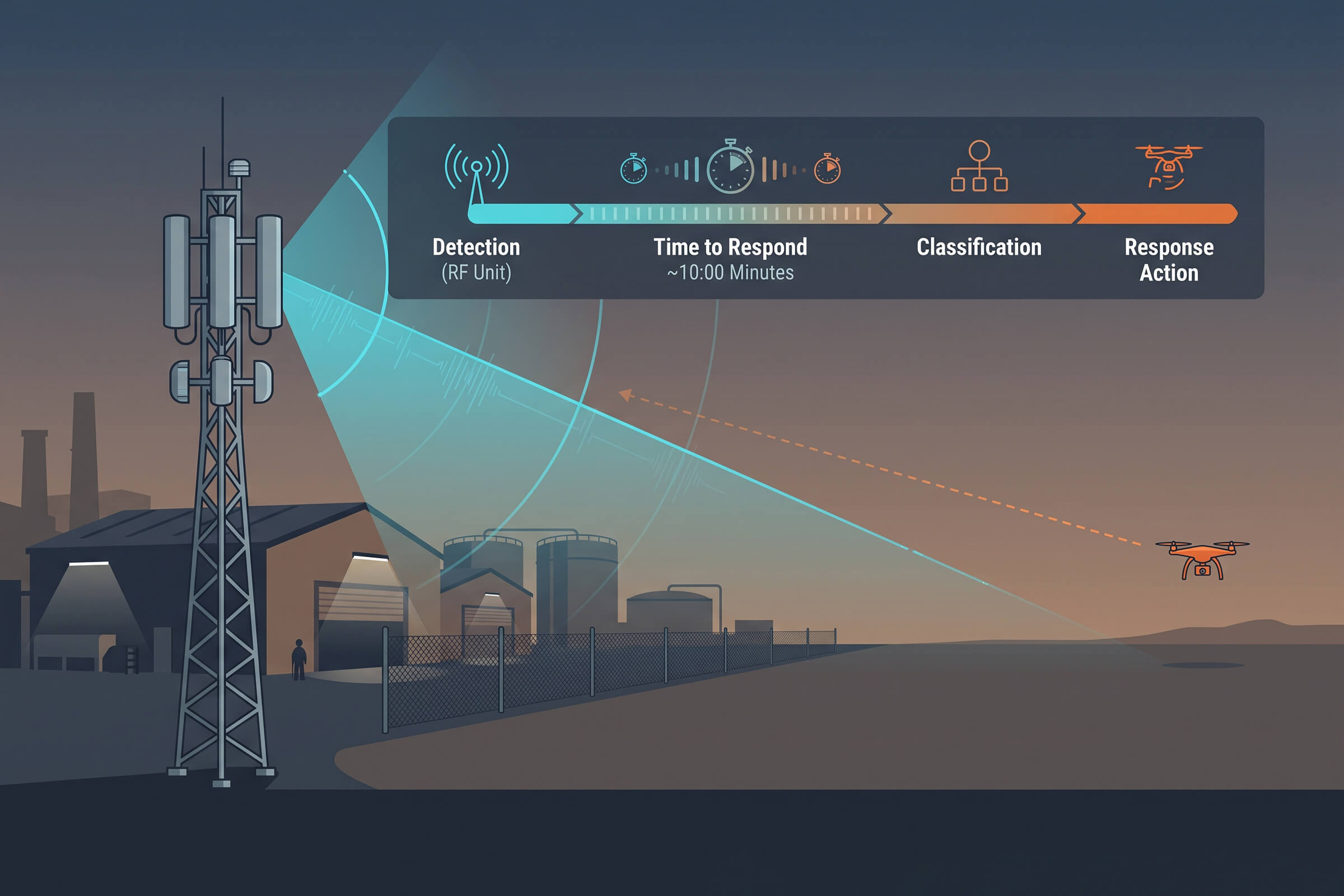
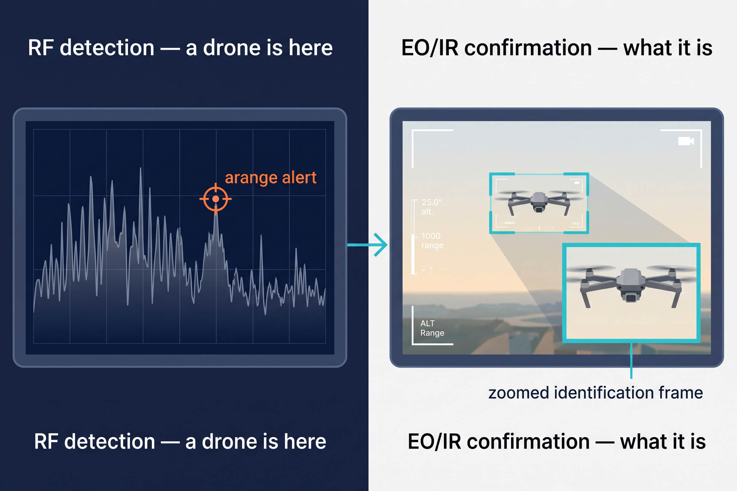
The full value of EO/IR tracking appears when it is wired into the detection chain. The sequence is simple and repeatable. A radio frequency or radar sensor detects a contact and generates an alert. The alert cues an EO/IR tracker, which slews toward the contact’s position. The tracker locks on, follows the drone, and begins recording. The operator now has a live video track, a documented flight path, and a recording that can be saved as evidence.

This loop is what separates a collection of sensors from a working system. Each layer does what it is good at. RF and radar are good at noticing over a wide area and without visual contact. EO/IR is good at confirming and recording over a narrower field but with certainty. Alone, each is incomplete. Wired together, they cover the whole chain from detection to documented incident.

The recording matters more than most buyers expect. Drone incidents are rarely one-off events resolved on the spot. They generate follow-up: security reviews, regulatory reports, sometimes legal action. A system that produces a clean, time-stamped video record of every incident pays for itself in the quality of the documentation it leaves behind.

The decision is rarely either-or. Many deployments use the T100 for long-range early confirmation and the VAR300 for close-in tracking and coverage of the critical core. The two layers overlap, which is exactly how a visual confirmation system should be built, redundant where it matters and economical where it does not.

The T100 is the long-range answer. By fusing radar and radio frequency sensing with dual-spectrum imaging, it holds a visual track at ranges that a single-spectrum tracker cannot reach. It is the choice for wide-open sites, airfields, ports, and energy facilities, where a drone may first appear far beyond the perimeter, and the operator needs to see it and track it before it gets close. The edge processing keeps the whole chain responsive without streaming raw video to a central server.

The VAR300 is the workhorse for continuous, unattended surveillance at moderate range. Its 640 by 512 infrared channel and AI-driven tracking make it ideal for sites where the drone is expected to appear at closer distances, inside a perimeter, above a facility, over a venue, and where the priority is round-the-clock coverage with minimal operator burden. It watches so a person does not have to.

Not every site needs the same level of visual tracking, and understanding the difference between short-range and long-range confirmation saves money and frustration. The two LZ TECH trackers illustrate the split cleanly.

Choosing the Right Tracker

Where EO/IR Tracking Earns Its Keep

Some sites need visual confirmation more than others. Airports and aviation facilities, where a confirmed drone sighting has immediate operational and regulatory weight. Critical infrastructure, where an intruder’s identity and intent change the response. Event venues and public gatherings, where a documented track supports both security decisions and later review. Correctional facilities, where evidence of a smuggling attempt matters as much as stopping it.

In each case, the pattern is the same. Detection alone leaves the operator guessing. Adding a visual track removes the guesswork. The choice between a detection-only system and one with EO/IR confirmation is really a choice about whether the site needs to know or needs to prove. Most sites that take drone threats seriously need both.

The operators who have run real incidents describe the same thing. The moment that matters is not the first beep on the screen. It is the moment the camera locks on, the picture clarifies, and the operator sees the drone, its shape, its path, and its behavior. That is the moment the situation changes from a vague alarm to a manageable event. Everything before that moment is preparation. Everything after it is a response.

There is a broader point worth making. Drone defense is often described as a sensor problem, and it is, but the sensors are not interchangeable. They answer different questions at different stages. RF answers whether something is there. Radar answers where something is, without identifying it. EO/IR answers what it is, and holds the proof. A system that skips the last stage is a system that notices problems but cannot resolve them.

The T100 pushes the same idea further by combining visible and thermal imaging with radar and radio frequency sensing. When one channel is degraded by weather, another compensates. Radar is not fooled by darkness or fog the way a visible camera is. Thermal imaging sees heat through conditions that defeat visible light. Multi-source fusion is, at its core, a bet against any single channel failing at the wrong moment. That redundancy is what makes long-range, around-the-clock visual tracking achievable at all.

The VAR300’s dual-mode design reflects this. Its visible channel handles identification in daylight, while its infrared channel carries the load at night and in poor visibility. The two channels together mean the system does not have a dead shift when the sun goes down. For a site that needs continuous coverage, that matters more than any single spec.

Real deployments happen in the dark, in rain, in fog, and in the low-contrast light of dawn and dusk. These are the conditions that separate a tracker that works in a demo from one that works in the field. Electro-optical and infrared channels are complementary for exactly this reason: visible light gives detail and identification when there is light, while infrared gives detection when there is not.

Weather, Night, and the Conditions That Test Trackers

The Bottom Line

The last kilometer of drone defense is the one most people forget about. It is the step between noticing a blip and holding a documented, confirmed drone in view. It is the step that filters false alarms, guides the response, and produces the evidence that survives after the drone is gone.

RF and radar tell you something is there. EO/IR tells you what it is, where it is going, and can show it to anyone who needs to see. For any site where a drone incident would trigger a report, an investigation, or a legal process, that last kilometer is not optional. It is the difference between a sensor that notices and a system that proves.

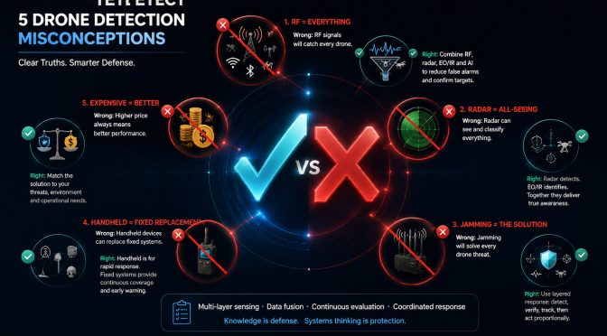
5 Drone Detection Myths That Cost Buyers Money

What Buyers Get Wrong About Drone Detection

Drone detection is a young market, and young markets breed misconceptions. Sales brochures overstate capability. Online forums repeat half-truths. And buyers, facing a genuinely complex technical decision, reach for the explanation that sounds most reassuring. The result is a set of widely held beliefs about drone detection that are, at best, incomplete and, at worst, actively misleading.

This article walks through five of the most common ones, explains where each goes wrong, and points toward the reasoning that actually holds up when the drone shows up.

Myth 1: RF Detection Covers Everything

The claim: a radio frequency detection system that covers the right frequency bands will catch every drone. The reasoning feels sound. Drones use radio signals, so monitoring those signals should catch them all.

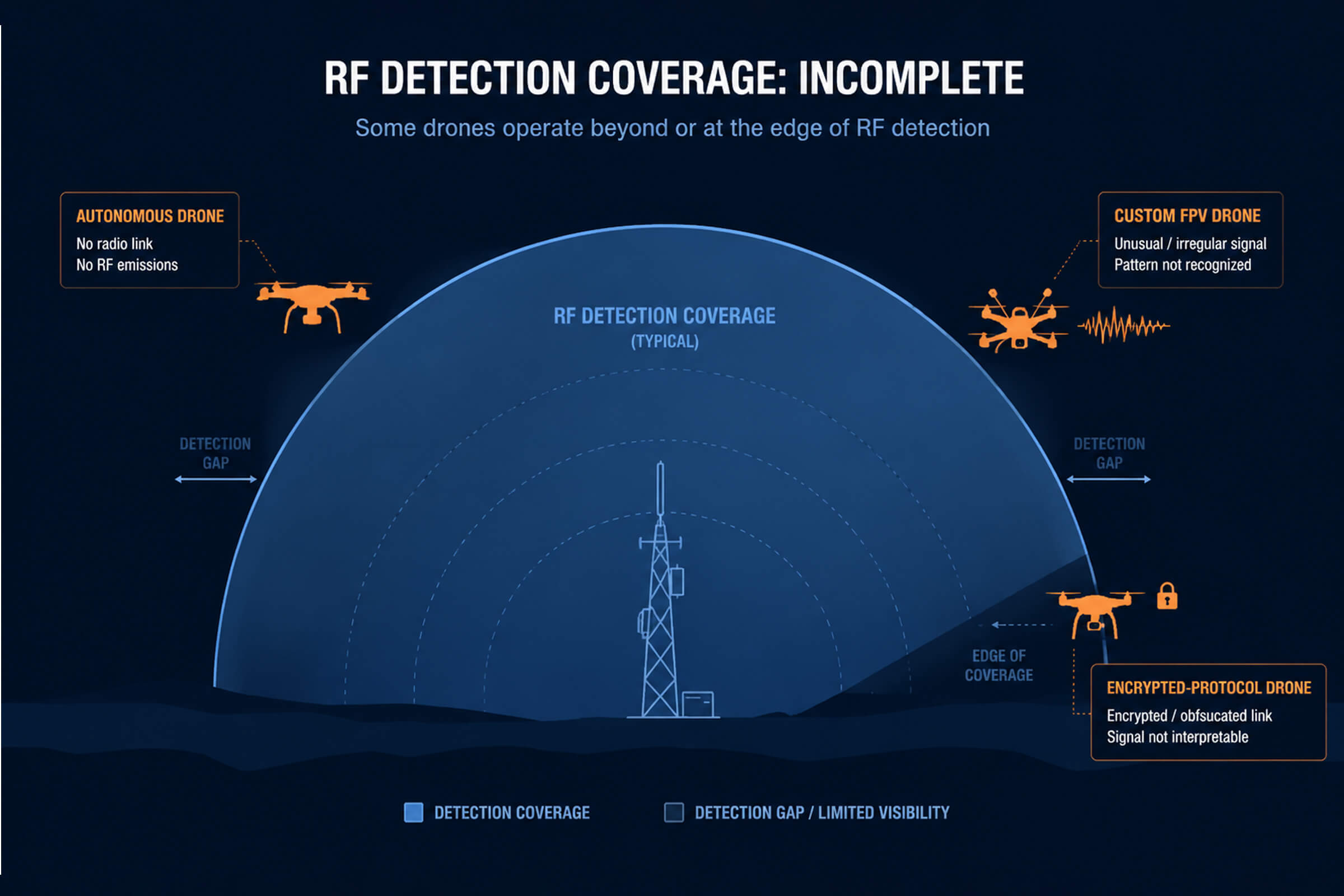
The reality is more limited. RF detection works by recognizing the radio signatures of known drone types. It is very good at identifying popular commercial models, the DJI and Autel aircraft that make up most of the drone population. Where it can fall short is with drones that do not use standard communication links: fully autonomous aircraft that fly a pre-programmed route without a live control link, drones using non-standard or encrypted protocols, and custom-built airframes with unusual signal patterns.

This does not mean RF detection is weak. It means RF detection is one layer. A robust system pairs RF detection with other sensing, radar for detecting non-emitting aircraft and electro-optical for visual confirmation, so that the gaps in one layer are covered by the others. Treating RF as the whole answer is the fastest way to be surprised by the drone it does not catch.

Myth 2: Radar Is Enough On Its Own

The claim: radar is the gold standard of airspace detection, so a radar unit solves the drone problem. It is a natural assumption. Radar has been the backbone of air defense for decades.

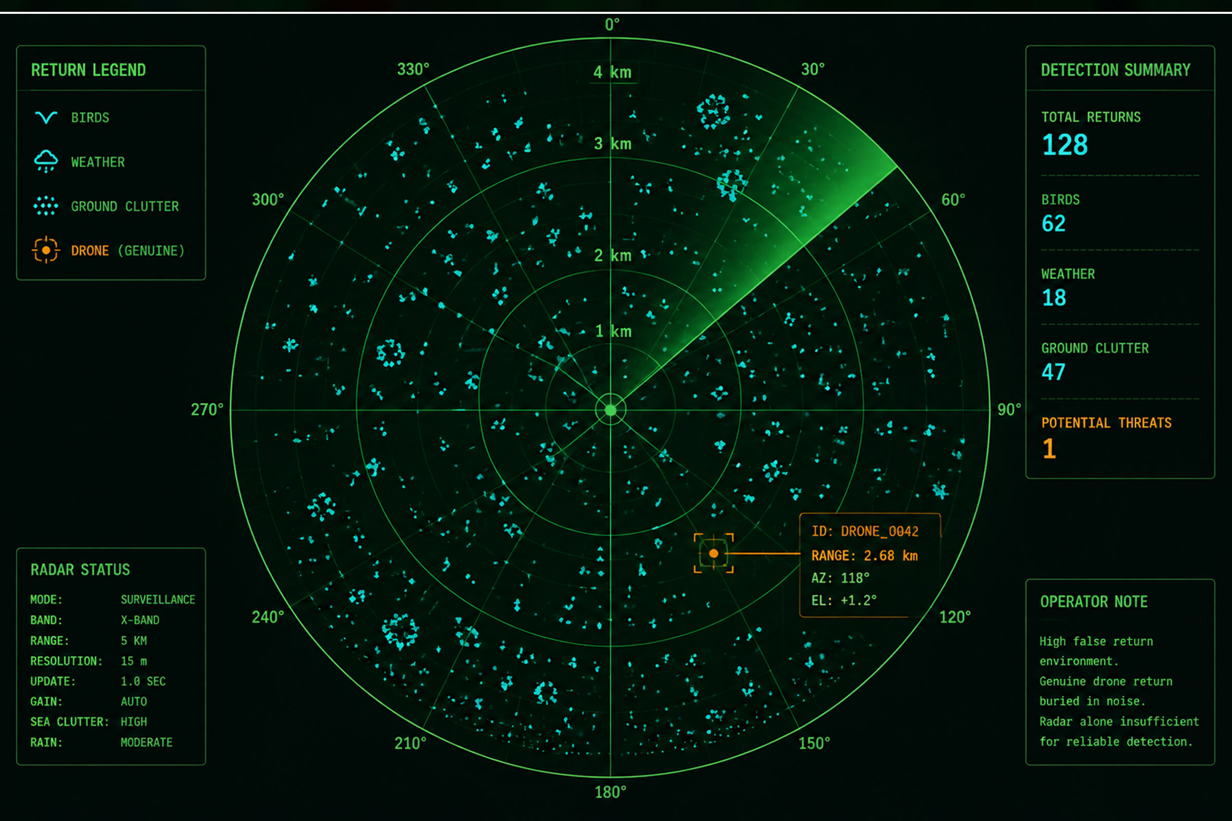
The problem is what radar was designed to detect. Traditional radar is built for large, fast, metallic aircraft. Drones are small, slow, and often made of plastic and composites. A consumer drone presents a radar cross-section that is a tiny fraction of an aircraft’s, which means radar either misses it entirely or flags so much clutter, birds, weather, and ground returns that the operator drowns in false alarms.

There is a second issue. Radar tells you that something is there and roughly where. It does not tell you what it is. For a drone detection system, identification matters: knowing whether a contact is a DJI quadcopter or a flock of birds is the difference between a useful alert and noise. Radar works best as one sensor in a fused system, providing a position for the RF and electro-optical layers to confirm and identify, not as a standalone answer.

Myth 3: A Handheld Detector Replaces a Fixed System

The claim: a handheld detection device is cheaper, portable, and does the same job as a fixed installation. On paper, it is an attractive trade, more flexibility for less money.

The reality is that handheld and fixed systems solve different problems. A handheld unit like the H3 Pro or HDJ 3.0 gives an operator on patrol the ability to detect and localize a drone in their immediate area. It is excellent for mobile teams, event security, and rapid response. But it is inherently limited by the operator: it only detects what it is pointed toward, it only works when someone is holding it and watching the screen, and it cannot maintain the continuous, around-the-clock coverage that a fixed installation provides.

A fixed system, by contrast, runs continuously, covers a defined area, and feeds a command platform that logs every contact. For a facility that needs persistent protection, an airport, a correctional institution, or an energy site, a handheld device is a supplement to a fixed system, not a substitute. The right comparison is not handheld versus fixed. It is the role each fills and whether the site needs continuous coverage or on-demand capability.

Myth 4: Jamming Is a Universal Solution

The claim: if you can jam a drone’s control signal, you have solved the problem. Just switch it on, and the drone falls out of the sky. It is the most seductive of the five myths because it sounds decisive.

The reality has three complications. First, jamming is not universally legal. In most countries, active jamming by private parties is restricted or prohibited because it interferes with the legitimate radio spectrum. A facility that buys a jammer it cannot legally use has bought a paperweight.

Second, jamming is not always effective. A drone flying a pre-programmed autonomous route does not need a live control link to complete its mission. Jam its signal, and it continues on its path. Drones with strong return-to-home logic will simply fly home. And the same jamming energy that disrupts a drone also disrupts legitimate communications nearby, a serious problem at a site that depends on its own wireless systems.

Third, jamming does not tell you anything. To jam a drone, you first have to know it is there, what it is, and where it is. That is exactly what the detection layer provides. Jamming is a response measure that depends entirely on detection. It is not a solution in itself. It is the last step in a chain that starts with detection and identification.

Myth 5: More Expensive Means Better Coverage

The claim: in drone detection, as in most things, you get what you pay for, and the highest-priced system must be the best. It is a comfortable assumption because it removes the burden of actually understanding the technology.

The reality is that coverage and capability do not track price in any simple way. A single expensive sensor placed at the center of a site still leaves the perimeter uncovered. A well-designed network of mid-range sensors, correctly spaced and properly fused, will outperform a single flagship unit every time. The value in drone detection is in the architecture, the placement, the overlap, the fusion, not in the price tag of any single component.

The better question to ask is not how much a system costs, but whether it covers the site’s actual geometry, whether it detects and identifies the drones that actually threaten the facility, and whether it feeds a command layer that turns detection into a response. A system that answers those questions well at a reasonable price is worth more than an expensive one that does not.

How to Evaluate a Vendor Without the Hype

Given how many claims float around this market, the practical question for a buyer is how to cut through them. Three questions do most of the work.

First, ask what the system does not detect. Every technology has limits, and a vendor who will not name theirs is either unaware of them or hoping you do not ask. A credible vendor can tell you, specifically, where their coverage drops off, which drone types are harder to see, and what terrain or clutter degrades performance.

Second, ask for a demonstration in your environment, not in a brochure. Drone detection performance is a function of the local RF environment, the terrain, and the specific threats you face. A system that performs well in a vendor’s clean test range may behave very differently at a site full of competing signals. A live test, against the drones you actually worry about, is worth more than any specification sheet.

Third, ask how the system scales. A detector that works as a single unit is one thing. A detector that networks cleanly with others, fuses into a command layer, and extends to cover a larger site over time is another. Buy the architecture, not just the box, because the drone threat is not going to get simpler.

A related misconception is that a drone over a facility is a single event to be handled once and forgotten. The operators who live with the problem know better. Drone incursions repeat. The same operator, the same airframe, the same route, over and over, testing the response each time. What changes the pattern is not a single interception. It is the operator’s growing certainty that the facility is watching, logging, and responding consistently.

This is where detection earns its keep as a deterrent, not just a sensor. A facility that reliably detects, records, and reports every incursion builds a reputation that spreads through the small community of people who fly drones where they should not. Word travels. A site that is known to document everything and respond every time attracts fewer repeat offenders than a site that is known to be asleep at the wheel.

There is a practical cost angle too. The comparison buyers should run is not the price of a detection system against nothing. It is the price of the system against the cost of one unmonitored incident: the operational downtime, the liability, the regulatory fine, the insurance premium increase, the reputational damage. For an airport, a single closed runway costs far more than a detection node. For an energy site, a single production interruption dwarfs the cost of a warning ring. Seen through that lens, detection is not an expense added to security. It is the cheapest layer of it.

What Actually Holds Up

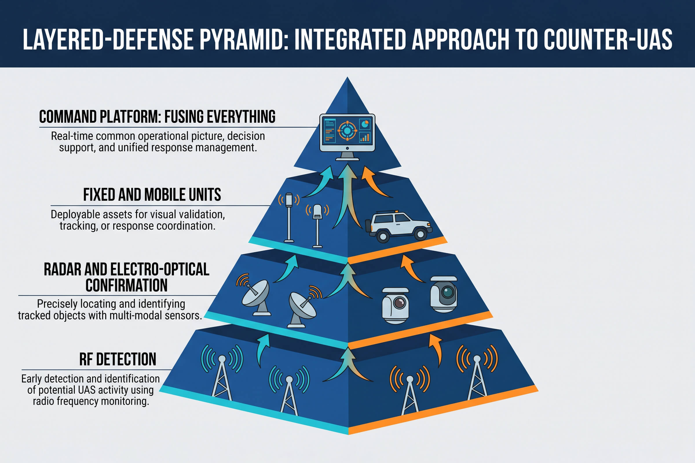
Step back from the myths, and a consistent principle emerges. Drone detection is a layered problem, and the layers reinforce each other. RF detection catches the radio-emitting majority. Radar and electro-optical layers catch what RF misses and confirm what RF flags. Fixed systems provide continuous coverage; handheld and mobile units provide on-demand capability where and when a fixed system cannot reach. And every layer, passive or active, depends on a command platform that fuses the feeds into a single coherent picture.

The buyers who succeed are the ones who resist the single-answer myth. They understand that no one sensor, no one frequency band, and no one technique catches every drone. They build systems the way the problem is actually structured, in layers, and they evaluate every purchase against one question: does this close a gap in my coverage, or does it just add another screen to watch? That question, asked honestly, is worth more than any brochure.

Drone Threats to Energy Infrastructure: A Layered Detection Approach

A Different Kind of Target

An oilfield, a gas processing plant, a power station, a solar farm, a substation. These sites share a trait that makes them uniquely exposed to drone threats: they are large, spread out, and packed with assets that cannot be moved. They also sit far from population centers, where airspace is loosely monitored, and a drone can approach from almost any direction.

For an energy operator, a drone is not just an airspace violation. Over a tank farm or a processing unit, a drone is a potential ignition source. Over a substation or a transmission line, it is a tool for reconnaissance that precedes more serious interference. The risk profile is different from that of an airport or a stadium, and the defense design has to match it.

What Makes Energy Sites Hard to Protect

Three factors make energy infrastructure a difficult C-UAS problem.

First, the scale. An oilfield can span hundreds of square kilometers, with wells, gathering stations, processing units, storage tanks, and pipelines scattered across the terrain. There is no single perimeter to fence, and no single choke point to monitor. A facility that can be walked end to end in an afternoon is one kind of problem. A facility that takes an hour to drive across is another, and the detection design has to account for that difference.

Second, the hazard. Energy sites contain flammable and explosive materials. Crude oil, natural gas, hydrogen sulfide, and refined products all change the stakes of an unauthorized flight. A drone that would be a nuisance over a warehouse is a genuine hazard over a tank farm. The concern is not just what the drone is carrying, but where it is flying and what it could strike or ignite.

Third, the remoteness. Many energy sites operate in deserts, coastal zones, or mountainous regions, far from the dense airspace monitoring of urban areas. Operators cannot rely on the surrounding air traffic infrastructure to flag an intruder. They need their own detection because no one else is watching the sky above them.

Layered Detection for Dispersed Assets

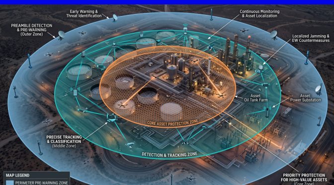
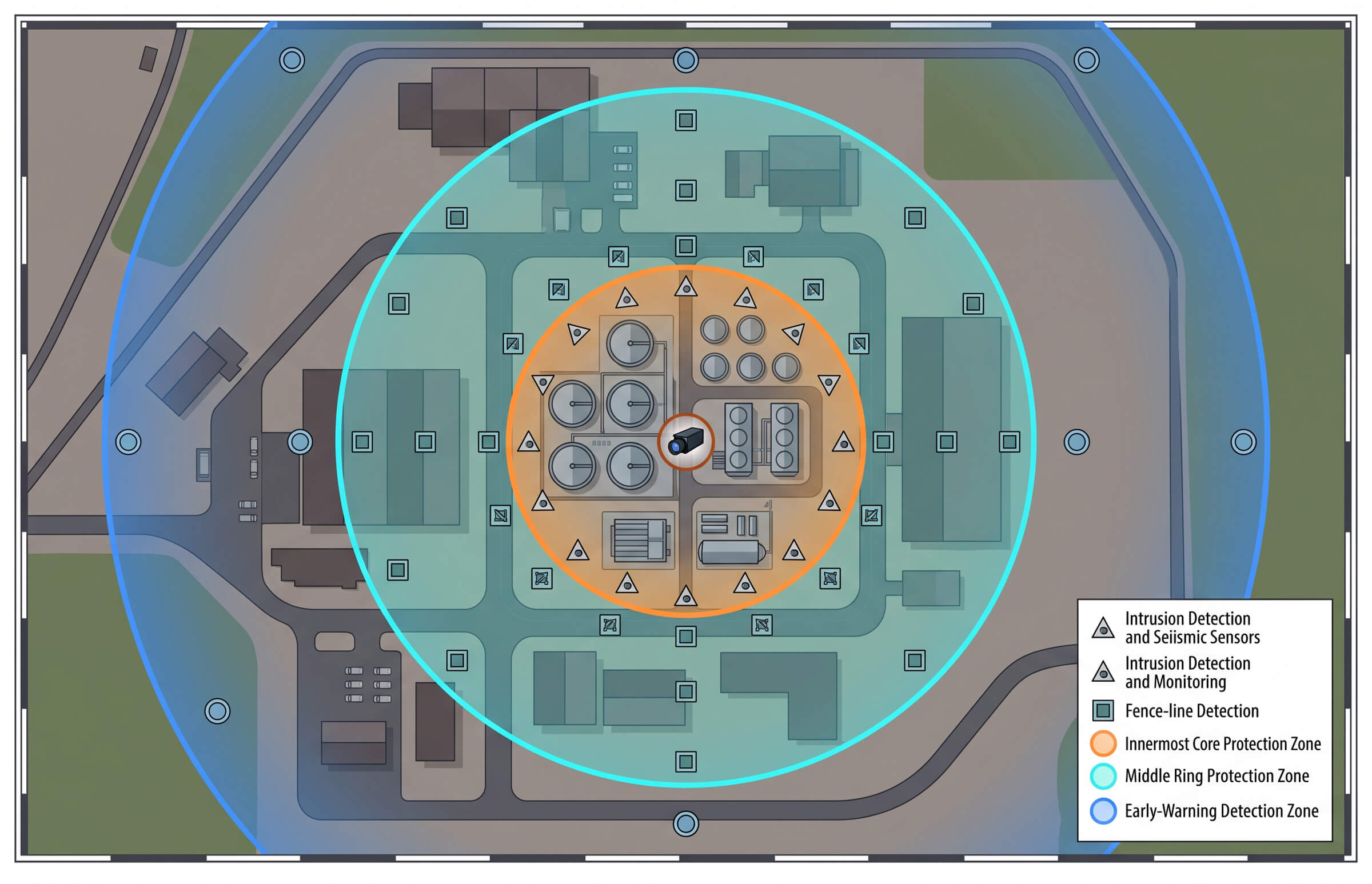
The right architecture for an energy site is layered, matching the natural structure of the facility: a wide early-warning ring around the outer boundary, a denser detection layer around the operating core, and a precise confirmation layer over the most critical assets.

The Warning Ring: Early Detection at Range

The outer layer uses fixed detection units to establish a wide early-warning ring. The DF5 Max is built for this role. It monitors the 400 MHz to 6 GHz band with a detection distance of up to 5 km and a direction-finding distance of up to 3 km, providing a direction-finding accuracy of 10 degrees RMS or better. It covers a full 360 degrees, tracks more than 35 drones simultaneously, and is rated IP66 for continuous outdoor operation in temperatures from minus 40 to plus 65 degrees Celsius.

Placed at the edges of the site, DF5 Max units give operators the earliest possible warning of an approaching drone. The goal of this layer is not precision. It is time. Every second of advance notice is a second the response team has to confirm, assess, and act.

The Core Layer: Dense Detection and Confirmation

Closer to the operating core, the detection density increases. Airborne D5-Air payloads operating in the 400 MHz to 6 GHz band extend detection over terrain that ground units cannot see, while the VAR300 adds electro-optical confirmation.

The VAR300 is an all-weather electro-optical and infrared tracker that provides visual confirmation of a detected contact. Where the RF layer tells an operator that a drone is present, the VAR300 tells them what it looks like. A commercial quadcopter, a fixed-wing survey aircraft, or something else. That visual confirmation is the difference between treating every RF contact as a threat and responding only to the ones that matter. It is also the layer that captures the video evidence needed for a later report or investigation.

Detection First, Response Second

A common mistake in energy-site drone defense is to jump straight to countermeasures before building the detection layer. The detection layer is where the operational value sits for three reasons.

First, detection is what tells you whether there is a problem at all. Most RF contacts near an energy site are not threats. They are commercial drones passing overhead, agricultural survey aircraft, or hobby flights in the general area. Without detection and identification, the operator has no way to tell which contacts deserve a response.

Second, detection builds the evidence base. Every logged contact, with its frequency, bearing, time, and visual record, contributes to a picture of what is normal and what is not. Over time, that picture is what lets the operator distinguish a routine overflight from a reconnaissance pattern. The drone that flies the same route three nights in a row is a different problem from the one that passes once and never returns, and only a continuous detection log reveals the difference.

Third, detection is the legally safe layer. Passive RF detection and electro-optical confirmation face few regulatory barriers in most jurisdictions, where active countermeasures may be restricted or require specific authorization. Building the detection layer first means the site is protected and compliant from day one, without waiting on the regulatory questions that surround more active measures.

Matching Coverage to the Threat, Not the Budget

The temptation in energy-site security is to buy the most powerful sensor and place it at the center of the site, expecting it to cover everything. The geometry does not work that way. A single central sensor leaves the outer reaches of a dispersed site uncovered, and the critical assets at the core are the ones that need the most protection, not the least.

A better approach matches coverage to asset priority. The operating core, the wells, processing units, and storage tanks get the densest, most redundant detection, with overlapping RF coverage and electro-optical confirmation on the highest-value assets. The surrounding area gets sparser early-warning coverage, enough to flag an approaching drone with time to spare. The result is a coverage map that reflects the actual risk, not a uniform blanket that protects everything equally and nothing well.

This principle holds at every scale. A small site still puts its densest coverage on the assets that matter most. A large site simply adds more rings, more nodes, and more confirmation layers as the geography expands. The logic does not change, only the number of sensors.

The Role of a Command Layer

An energy site with multiple DF5 Max units, D5-Air payloads, and VAR300 trackers is generating detection data from a dozen or more sources. Without a command layer to fuse that data, the operator is staring at a wall of separate feeds, trying to correlate them by hand. That is where the value is lost.

A command platform brings the feeds together onto one geographic display, fuses the RF tracks with the visual confirmations, and presents the operator with a single coherent picture of the airspace. It is the difference between a collection of sensors and a defense system. For a dispersed energy site, the command layer is not optional. It is what turns geographically scattered detection into a coordinated response.

The command layer also solves a staffing problem. Energy sites often run lean, with a small operations team covering a large area. A fused display means one operator can monitor the entire site’s airspace from a single station, instead of needing a person per sensor. That is a meaningful difference when the alternative is leaving gaps unattended.

A Practical Starting Point for Energy Operators

For an energy operator building a drone defense capability from scratch, the sequence matters.

Start with the warning ring: DF5 Max units at the edges of the site, establishing early detection and beginning to log activity. Add confirmation: VAR300 trackers on the highest-value assets, so that detection is followed by visual identification. Extend coverage: D5-Air payloads for terrain gaps and dispersed outer areas. Connect it all: a command platform that fuses every feed into one picture.

Each step adds capability on top of the previous one, and each step is compliant, passive, and immediately useful on its own. The site does not need to solve the whole problem at once. It needs to start detecting, start confirming, and start building the evidence base that will guide the next investment.

This staged approach also spreads cost over time. Instead of a single large capital outlay, the operator builds capability incrementally, and each stage generates the data that justifies the next. The warning ring proves the need. The confirmation layer proves the response. The command layer proves the value. By the time the full system is in place, its case has already been made with evidence, not assumption.

Regulatory and Insurance Drivers

The case for energy-site drone detection is increasingly driven by two forces beyond the immediate threat. The first is regulation. As airspace authorities extend drone-safety rules around critical infrastructure, operators face growing pressure to demonstrate that they monitor and manage low-altitude airspace over their sites. A facility with a documented detection capability is better positioned to show compliance than one without.

The second is insurance. Underwriters pricing a large energy facility increasingly ask about drone risk, and a site that can show continuous airspace monitoring and a logged detection history negotiates from a stronger position than one that cannot. Neither of these forces is a direct attack. Both are real, and both favor the operator who builds detection before it becomes a requirement rather than after.

The Energy-Site Difference

Energy infrastructure is where drone detection stops being a security nicety and becomes an operational requirement. The scale of the sites, the hazard of the materials, and the remoteness of the locations all raise the stakes of an unauthorized flight. A drone over a tank farm is not the same problem as a drone over a warehouse, and it should not be solved with the same off-the-shelf answer.

The answer that fits is layered: a wide warning ring, a dense detection core, electro-optical confirmation on the critical assets, and a command layer that fuses it all. For energy operators, that is the difference between hoping a drone is not a problem and knowing, with time to act, when one is.

From Single Point to Network: Drone Detection for Borders and Long Perimeters

Why Long Perimeters Break Single-Point Detection

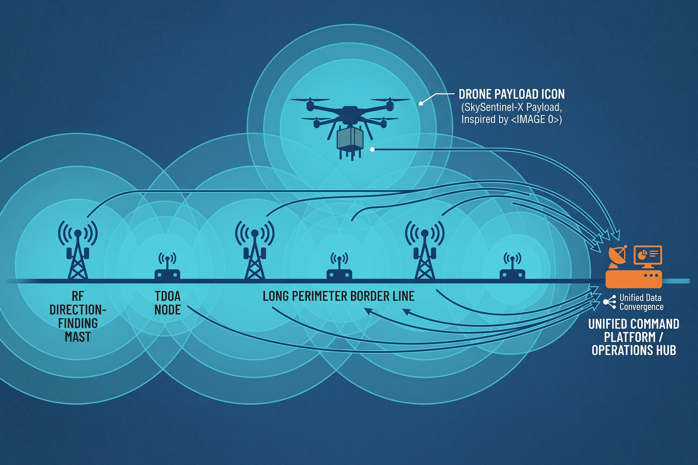
A border crossing, a pipeline corridor, a coastline, a facility fence line that runs for tens of kilometers. These are the sites that quietly defeat most drone detection systems. The problem is not that the sensors are weak. It is that the geometry does not cooperate.

A single detection unit, no matter how sensitive, sees the airspace from one fixed point. Range falls off with distance. Terrain blocks line of sight. A drone flying low behind a ridge or a stand of trees disappears from a lone sensor’s view. Along a long, irregular perimeter, the only thing a single point gives you is a single point of failure, and a long list of blind spots.
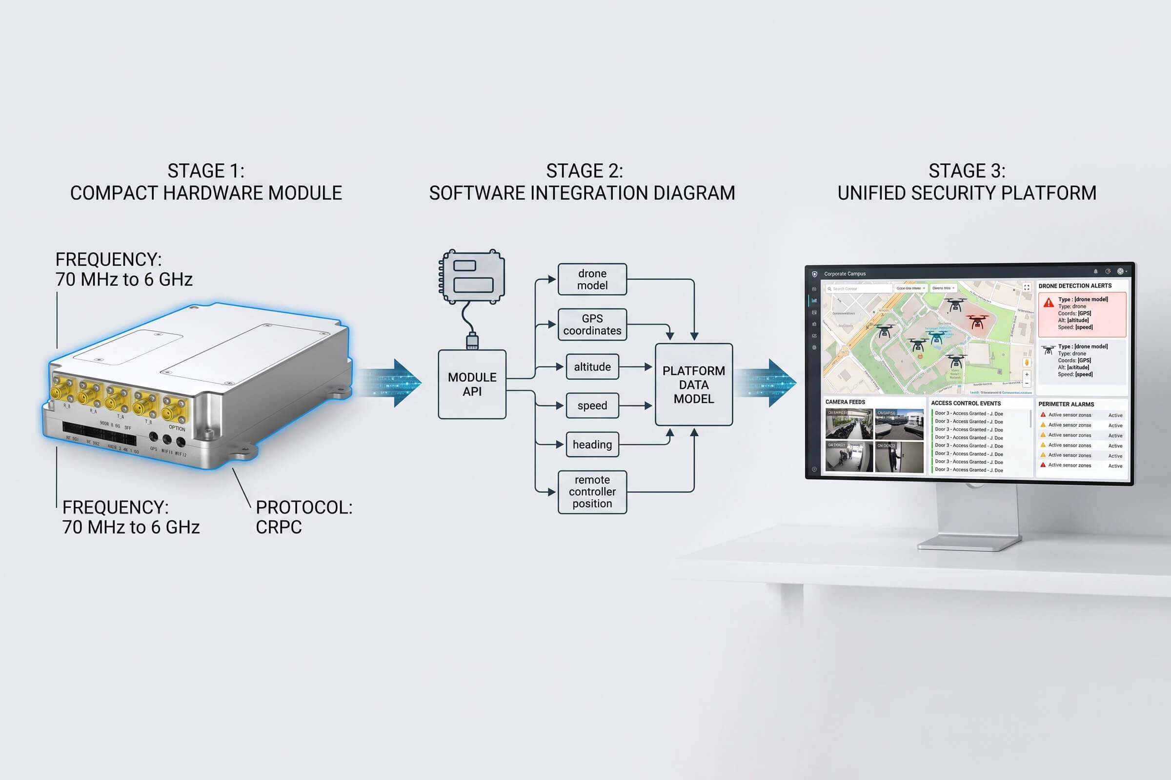
The shift from single-point to network coverage is the defining challenge of long-perimeter drone defense. It changes what you buy, where you place it, and how the pieces talk to each other.

The Physics of Perimeter Coverage

Two physical realities shape every long-perimeter deployment. First, radio frequency detection is fundamentally line-of-sight. A detection system operating in the 30 MHz to 6 GHz band sees a drone’s command-and-control signal as long as there is a clear path between the drone and the sensor antenna. Hills, buildings, heavy vegetation, and the curvature of the earth all interrupt that path.

Second, detection range is a maximum, not a guarantee. A sensor rated for eight kilometers will reliably see a low-flying drone at a fraction of that distance, because the drone’s signal has to compete with terrain, weather, and the clutter of the surrounding RF environment. A drone hugging the ground a few hundred meters from the sensor can be harder to detect than a drone flying high and clear at five times the distance.

The consequence is that coverage is a question of geometry, not just equipment quality. To cover a long perimeter without gaps, you need multiple sensors placed so their coverage areas overlap. Each sensor covers its own sector. The overlaps are what close the gaps. That is what a network gives you that a single point cannot.

Two Ways to Find a Drone: Direction Finding vs. Positioning

When you network sensors along a perimeter, the next question is what each node contributes. There are two complementary approaches, and they answer different questions.

Direction Finding: Where Is the Signal Coming From?

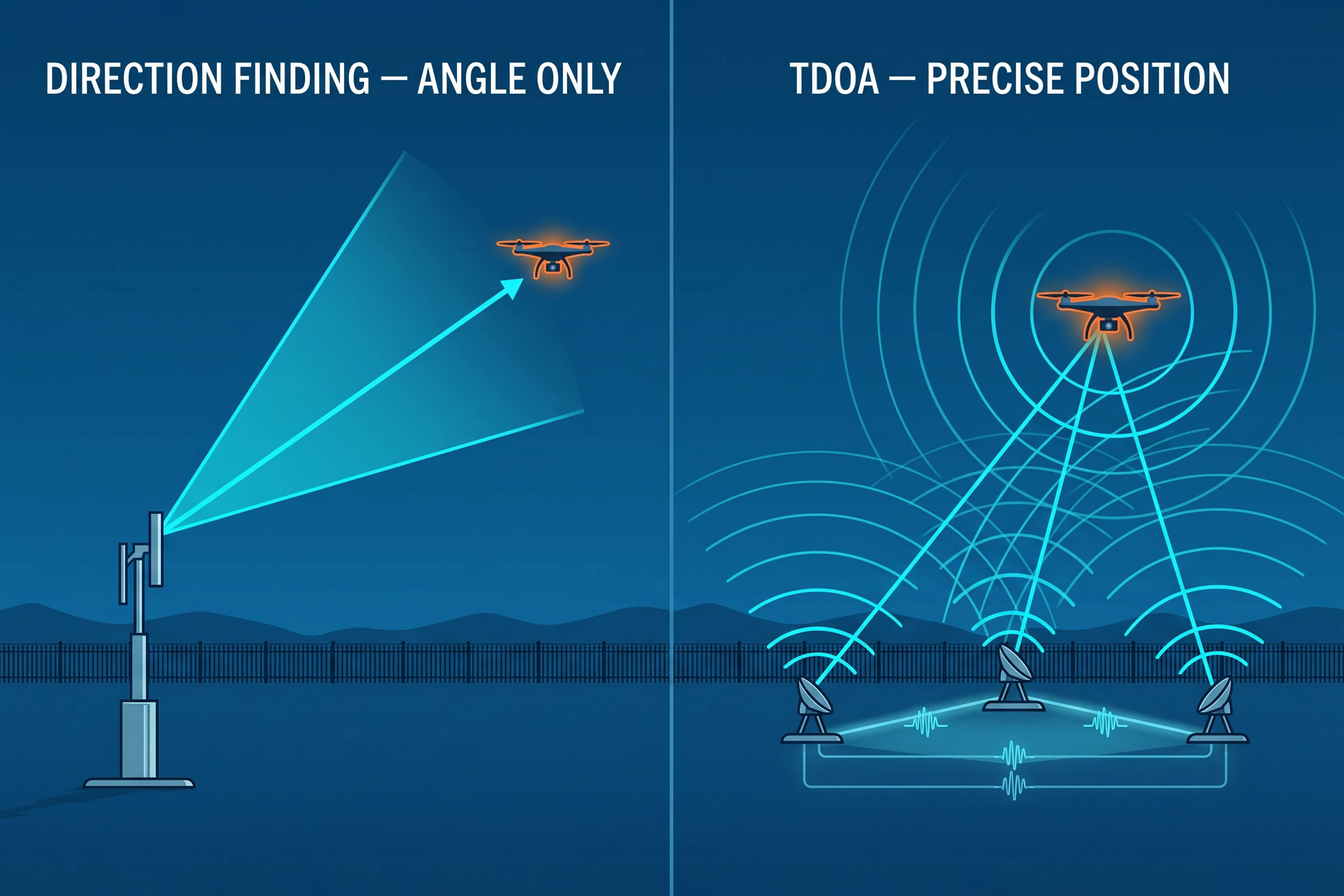
Direction-finding systems like the DFJ83 and DFJ53 measure the angle of arrival of a drone’s radio signal. A single DFJ83 unit detects a drone at up to 8 km and computes its bearing with a direction-finding accuracy of 3 degrees RMS or better. That tells the operator the direction of the threat but not its exact position along that bearing. It is a line, not a point.
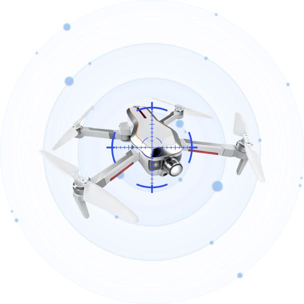
Deploy two or three direction-finding units across the perimeter and the picture sharpens. Each unit draws its own bearing line. Where the lines cross is the drone. This is triangulation, and it is the oldest and most robust way to locate a radio source without emitting anything.

The trade-off is precision versus simplicity. Triangulation from two or three widely spaced direction-finding units gives a useful position estimate, but the accuracy depends on the geometry. When the drone is far outside the triangle formed by the sensors, the bearing lines cross at a shallow angle and the position estimate degrades. That is why direction finding is best suited to early warning and cueing, and why precise localization is handed off to a technique built for it.

TDOA Positioning: Where Is the Drone, Precisely?

Time Difference of Arrival, or TDOA, is a different and more precise technique. Instead of measuring the angle of a signal, a TDOA network measures the tiny difference in the time a drone’s signal reaches three or more synchronized receivers. Because radio waves travel at a known speed, those time differences convert directly into a position.

The D5-B is a passive TDOA node built for exactly this role. A single D5-B covers the 30 MHz to 6 GHz band with a detection range of up to 3 km and a detection height of up to 1 km. It tracks more than 30 drones simultaneously and delivers a positioning accuracy better than 10 m RMS, with a response time of 2 seconds or less. Because it is a passive receiver, it emits nothing, runs on standard AC power at around 60 watts, and is built to IP66 for year-round outdoor duty in temperatures from minus 40 to plus 70 degrees Celsius. At 3 kg, it deploys on a fixed mast or a temporary tripod in minutes.

The difference between the two approaches matters. Direction finding gives you a bearing and, with multiple units, a rough position. TDOA gives you a precise position directly. In practice, a well-designed perimeter uses both: direction finding for early detection and rough cueing, TDOA for precise localization when the drone gets close enough to matter.

Adding the Third Dimension: Airborne Coverage

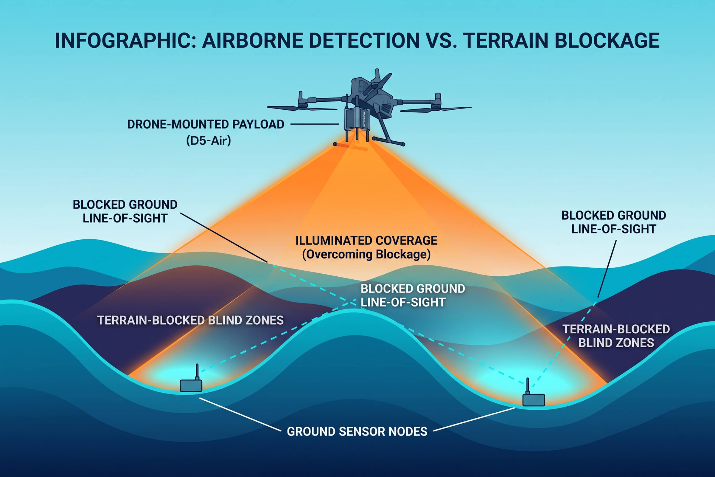
Ground-based sensors share a common limitation: they see the world from roughly eye level, and the terrain between them and a low-flying drone is full of obstructions. An airborne sensor removes that limitation.

The D5-Air is a drone-mounted detection payload that operates in the 400 MHz to 6 GHz band with a detection range of up to 5 km. Mounted on a platform such as the DJI M400 or M350, it climbs above the terrain and looks down into the valleys, behind the ridgelines, and across the water where ground nodes cannot see. Airborne nodes extend the network vertically, filling the coverage gaps that terrain creates for ground-based sensors.

This is not a replacement for ground infrastructure. It is a complement. A long-perimeter network works best when fixed ground nodes provide continuous baseline coverage, and airborne nodes are launched to close specific gaps, investigate ambiguous contacts, or respond to a fast-moving threat that has slipped behind terrain.

Designing the Network: Nodes, Spacing, and Handoff

The practical design questions for a long-perimeter deployment are spacing, redundancy, and handoff.

Spacing is driven by the detection range of the node and the terrain it must cover. A DFJ83 with an 8 km detection range can cover a longer stretch than a DFJ53 with a 5 km range, but only where the terrain allows a clear line of sight. In flat open terrain, nodes can be spaced near their maximum range, with overlap to eliminate gaps. In broken terrain, spacing tightens and the network grows denser.

Redundancy means no single node is critical. If one sensor goes down for maintenance or fails, its neighbors expand their effective coverage to close the gap. A network designed with overlapping sectors tolerates the loss of any single node without opening a hole in the perimeter.

Handoff is what happens when a drone crosses from one node’s sector into another’s. In a network, the tracking of a moving drone should transfer cleanly from node to node, with the position estimate becoming progressively more accurate as more sensors contribute. This requires a command layer that fuses the feeds from every node into a single track. That is the same principle that separates a collection of sensors from a coordinated defense.

Why Passive Matters Along a Perimeter

One property of the network is worth stating plainly: the detection layer along a long perimeter should be passive. Direction finding and TDOA both work by receiving, not emitting. A DFJ83 direction-finding unit and a D5-B TDOA node both listen for drone signals and never transmit.

This has practical consequences. Passive detection does not interfere with legitimate radio traffic, the communications, navigation, and broadcast systems that operate near any border or infrastructure corridor. It does not require spectrum licenses or special authorizations in most jurisdictions. And it does not announce its own presence: a drone operator cannot detect a passive receiver the way they can detect an active radar sweep. For a long perimeter where the goal is continuous, unobtrusive monitoring, passive detection is the right foundation.

There is an operational benefit too. Because a passive network emits nothing, it can run indefinitely without drawing attention, building a continuous record of airspace activity that becomes the baseline for recognizing what is normal and what is not.

Passive operation also simplifies power and backhaul in remote terrain. A TDOA node drawing around 60 watts can run from a small solar or battery-backed supply where grid power is unavailable, and its data rides a modest network link. The lighter the infrastructure footprint, the more practical it becomes to deploy detection nodes along a border stretch that sits far from any control room.

From Single Point to Network: A Practical Progression

Facilities rarely leap from nothing to a full perimeter network in one step. A more common progression starts with a single high-risk sector.

Step one is to cover the most exposed sector with a direction-finding unit, a DFJ83 or DFJ53, placed at the point of highest traffic or greatest vulnerability. This establishes a detection baseline and begins documenting drone activity in the sector.

Step two adds TDOA nodes. As the D5-B network grows from two to three to four nodes, the system shifts from detecting drones to precisely locating them. The position data now supports a real response, not just an alert.

Step three extends the network along the full perimeter, adds airborne D5-Air coverage for terrain-blocked sectors, and connects everything through a command platform that fuses the feeds into one airspace picture. At this stage, the facility has moved from a single point of detection to a coordinated, redundant, precise network. That is the difference between knowing a drone is out there somewhere and knowing exactly where it is, right now.

The Bottom Line for Long-Perimeter Sites

Long perimeters are where drone detection systems earn their keep, and where weak designs fail first. The site that installs one powerful sensor and declares the perimeter covered has solved the easiest part of the problem. The hard part is the geometry: the terrain, the gaps, the blind spots, and the need for coverage that survives the loss of any single node.

The answer is not a better single sensor. It is a network. Direction finding for early detection. TDOA for precise positioning. Airborne nodes for terrain gaps. A command layer that fuses it all into one picture. For borders, coastlines, pipelines, and facility fences, that is the difference between monitoring a point and defending a line.

Counter-Drone Regulation Is Catching Up: H2 2026 Trends and What They Mean

The Regulatory Tide Is Coming In — Faster Than Expected

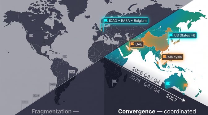
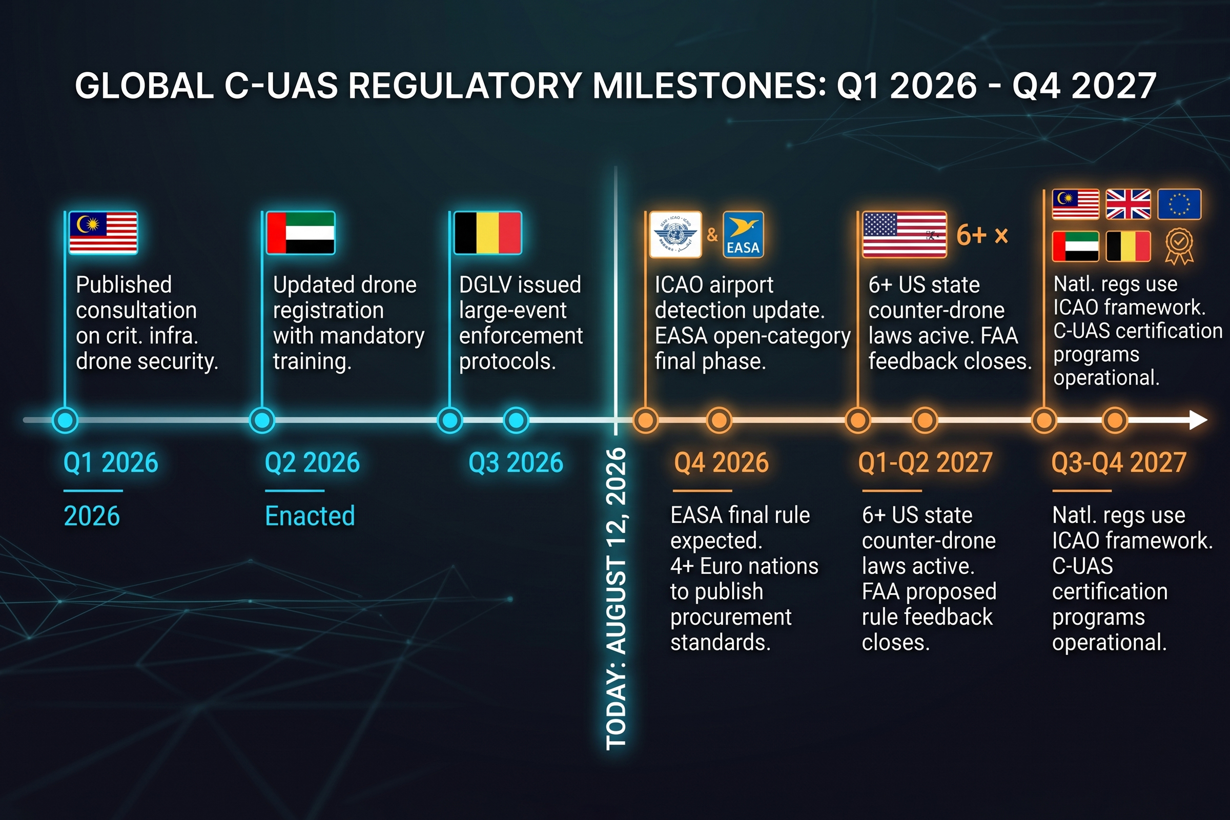
In July 2026 alone, three separate developments shifted the global C-UAS regulatory conversation. Belgium’s civil aviation authority imposed new enforcement protocols for drone violations near large public events. The International Civil Aviation Organization (ICAO) released updated airspace risk management guidance that explicitly addresses unauthorized drone operations near airports. And the European Union Aviation Safety Agency (EASA) continued its review of open-category drone regulations, with industry observers expecting tighter operational limits before the end of the year.

Each development, taken alone, is incremental. Together, they point to a regulatory pattern that corrections facilities, airport operators, and critical infrastructure managers can no longer afford to treat as future-looking: the gap between what drones can do and what regulation allows is still wide, and it is closing from the enforcement side rather than the legislation side. That distinction matters for procurement planning.

Belgium: One Summer of Incidents Writes Policy Faster Than Parliament

During the first half of 2026, Belgium’s Directorate General of Civil Aviation (DGLV) recorded a sharp increase in drone violations at large public events — music festivals drawing tens of thousands of attendees, outdoor sporting venues, and cultural gatherings in urban centers. The incidents followed a recognizable pattern: small commercial drones flying over crowded areas without the required flight authorization. Some carried cameras. Others were operated recklessly, with no apparent malicious intent beyond disregard for airspace rules.

The numbers that prompted the enforcement shift were hard to ignore. The DGLV documented 41 unauthorized drone flights over public events in the first five months of 2026 — more than the total for all of 2025. Several of the incidents involved drones hovering over audience areas at music festivals with attendance in the tens of thousands, where a loss of control or a deliberate act could have caused mass injury. No serious harm occurred, but the risk profile had shifted from theoretical to demonstrable. The enforcement protocols that followed were a direct response to that data — not a political decision, but an operational one forced by incident volume.

In response, the DGLV issued updated enforcement protocols that gave local authorities expanded authority to deploy counter-drone measures at events above a certain attendance threshold. The protocols did not introduce new legislation. Parliamentary processes take time, and Belgium’s legislative calendar was already full. Instead, the authority clarified existing law — arguing that the existing powers to protect public safety at mass gatherings already enabled drone detection and, where necessary, countermeasures. The update simply removed procedural ambiguity that had slowed enforcement.

The Belgian case matters because it illustrates how enforcement catches up to technology incrementally. Not through sweeping legislation, but through practical administrative clarifications that lower the barrier to action. For security teams managing stadiums, arenas, and festival grounds, this is the kind of regulatory shift that changes what is operationally possible on any given weekend.

ICAO: When a Guideline Becomes the Baseline

ICAO’s mid-2026 update to its airspace risk management framework addressed a topic that previous editions had only referenced in passing: the presence of unauthorized drones in controlled airspace around airports and other aviation-sensitive locations.

The updated guidance recommended that member states require drone detection capabilities as part of the security baseline for airports above a certain traffic threshold. It did not mandate specific technologies — ICAO guidance rarely does. But the framing shifted from the previous edition’s permissive “consider establishing” to an expectation-level “should establish” drone detection as part of an airport’s operational risk management.

For the C-UAS industry, ICAO guidance functions as a policy anchor. When national regulatory agencies draft their own binding regulations, they reference ICAO frameworks as the international standard. A recommendation at the ICAO level typically becomes a requirement at the member-state level within two to four years. Airport operators who begin deploying drone detection systems now — before the mandate — are building operational capability on their own timeline rather than scrambling to meet a regulatory deadline.

EASA and the Open Category: Where Consumer Drones Meet the Next Generation of Rules

EASA’s open-category regulation — the rule set that covers most consumer drones under 25 kilograms — has been under formal review since late 2025. The industry consensus is that the final update, expected before the end of 2026, will include three changes that matter for security operations: tighter geofencing requirements, mandatory remote identification for a wider class of consumer aircraft, and stricter operator registration rules.

The open-category review matters for the security industry because it determines what information is available to a drone detection system. Remote identification — the drone equivalent of a digital license plate — broadcasts the aircraft’s position, altitude, speed, and operator registration number. If EASA mandates remote ID for a larger class of consumer drones, RF-based detection systems can integrate that data directly, improving identification accuracy and reducing false positives.

The counterpoint is that mandatory remote ID does not solve the detection problem for high-threat scenarios. Deliberately non-compliant operators — the kind targeting prisons with contraband deliveries or flying over critical infrastructure — can disable or spoof remote ID broadcasts. Signature-based RF detection that identifies the radio protocol itself, not just the broadcast ID, remains the more reliable and harder-to-defeat layer for security facilities facing genuine threats rather than casual airspace violations.

The practical path forward for most security teams is to ensure their drone detection systems work with both remote ID broadcasts and protocol-level RF identification — covering both the compliant and non-compliant sides of the threat spectrum.

Beyond Europe: Other Jurisdictions Moving in Parallel

The regulatory momentum is not confined to Europe. In Southeast Asia, several national aviation authorities have begun drafting drone detection requirements for critical infrastructure sites, with Malaysia’s civil aviation body publishing a consultation paper in early 2026 on security protocols for drone operations near government buildings and energy facilities. In the Middle East, the UAE updated its drone registration and flight authorization system in June 2026, adding mandatory operator training requirements for any drone above 250 grams.

The United States has moved more slowly at the federal level, with the FAA’s drone security rulemaking still in the proposed rule stage as of mid-2026. However, individual states have been more active — at least six states have passed legislation authorizing law enforcement to deploy counter-drone measures in specific circumstances, primarily around correctional facilities and major event security. The patchwork approach at the state level is expected to push federal agencies toward a more unified framework by 2027.

The state-level activity is worth tracking in detail because it creates regulatory precedent that federal agencies can reference. California’s drone security bill, passed in early 2026, authorizes county sheriffs to deploy RF detection systems at correctional facilities and requires quarterly incident reporting to the state legislature. Texas followed with a broader authorization covering critical infrastructure — power plants, water treatment facilities, and oil refineries — and added a provision for law enforcement training on drone detection equipment. Florida, Georgia, Ohio, and Arizona have similar bills at various stages. The pattern is consistent: states are not waiting for the FAA. They are building operational C-UAS frameworks within their existing public safety authority, and the experience those states accumulate will inform the federal rulemaking process when it arrives.

What These Trends Mean for Procurement in Late 2026

There is also a market signal embedded in these regulatory developments that procurement teams should not overlook. When a regulator recommends that airports “should establish” drone detection as a security baseline — as ICAO did in mid-2026 — it creates a compliance-driven demand curve that is separate from the threat-driven demand curve. Threat-driven demand is reactive: a facility buys detection after an incident. Compliance-driven demand is structural: facilities buy detection because their operating license or liability insurance requires it. The second kind of demand is larger, more predictable, and more durable. It is the kind of demand that will define the C-UAS market over the next three to five years, and the deployments that are operational when the compliance mandates arrive will have locked in their position before the procurement wave begins.

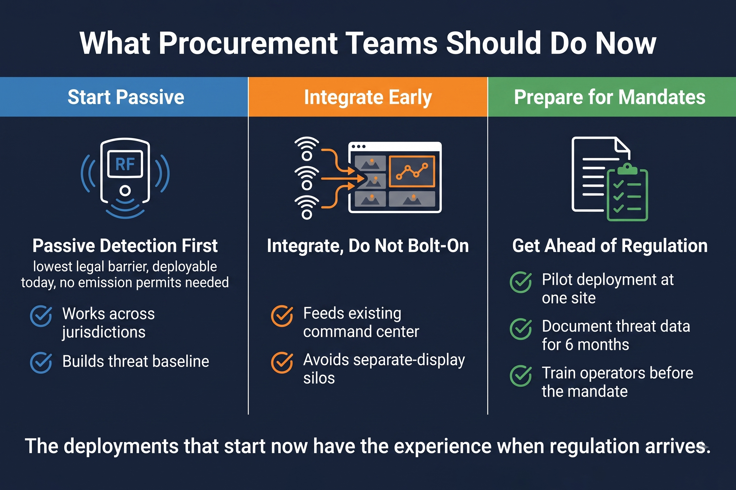
Three practical takeaways for security teams evaluating C-UAS decisions in the second half of the year.

First, passive RF detection is the safest regulatory starting point. Across all three major regulatory developments — Belgium enforcement protocols, ICAO airspace guidance, EASA open-category review — the common thread is that detection and monitoring occupy the first rung on the regulatory ladder. Active countermeasures may be authorized later, but passive detection faces fewer legal barriers today, in more jurisdictions, for a wider range of facility types.

Second, the regulatory environment increasingly favors integrated systems over standalone point solutions. ICAO guidance asks airports to establish drone detection as part of operational risk management, not as a bolt-on gadget. That means a system that feeds into the existing security command center — CCS, CRPCS, or an equivalent platform — rather than one that operates in isolation with a separate display and its own operator.

Third, the pace of regulatory change is accelerating, not slowing. Security teams that begin drone detection deployments now — even at a pilot scale at a single facility — will have operational experience and a documented threat baseline when regulations catch up. Teams that wait for the final rule to be published will discover that procurement timelines, installation cycles, and operator training do not compress simply because the regulation has arrived.

H2 2026: The Calendar Filling Up

The second half of 2026 brings a schedule of industry events that will further shape the regulatory conversation and provide concrete signals for procurement planning.

September hosts the Global Drone Security Summit in Amsterdam, where ICAO and EASA representatives are expected to present detailed enforcement frameworks and answer questions from the industry on implementation timelines. October brings the ICAO Assembly — a once-every-three-years meeting where member states collectively set the agenda for global civil aviation regulation. The Assembly’s outcomes on drone security topics will influence national regulatory calendars for the following three to five years.

Meanwhile, the rollout of national C-UAS certification programs continues at the operational level. At least four European countries are expected to publish updated drone detection procurement standards before year-end. These are the documents that will specify what a compliant drone detection system looks like — frequency ranges, response times, integration requirements — and they will shape the next generation of procurement specifications across the continent.

For the entire C-UAS industry, this is not a waiting game. It is a preparation window. The regulation is being drafted in meeting rooms right now. The deployments that begin now will have the experience, the training, and the documented threat data to operate confidently under any framework that emerges. The deployments that wait will start from zero inside a regulatory window they did not help shape.

CCS vs CRPCS: Choosing the Right C-UAS Command and Control Platform

The Software Layer That Turns Sensors Into a System

A drone detection network can have the best RF sensors on the market. But if the data from each sensor stays siloed on its own screen, the operator’s job does not get easier. It gets harder. Every extra display that a security officer has to monitor adds friction. In an incident, friction costs seconds that matter.

Command and control software is the layer that turns individual sensors into a coordinated defense. It takes raw detection data from multiple sources  —  RF direction finding, radar, electro-optical cameras.  and fuses it into one unified picture of the airspace. That fusion is where the real value sits. A drone detected by the DF10 Max on one side of the facility should appear on the same screen as a camera feed from the VAR300 tracking the same aircraft.

LZ TECH offers two platforms that address this problem at different depths: CCS and CRPCS. They come from the same platform lineage and share the same integration philosophy — but they serve different operational environments. Choosing between them starts with understanding what each one actually does.

CCS: Unified Situational Awareness for Multi-Sensor Sites

CCS  —  short for Command and Control System — is designed to bring detection data from multiple sensor types into one interface. It integrates inputs from RF direction-finding systems such as the DF10 Max and DF5 Max, radar units, and electro-optical trackers like the VAR300 and T100, displaying live drone tracks on a geographic map of the protected site.

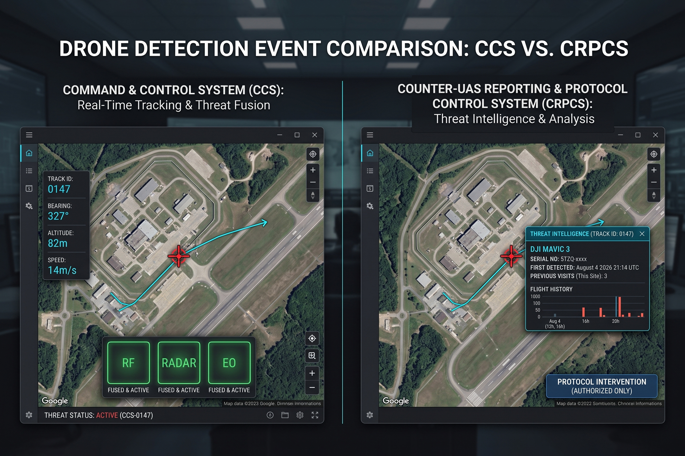
The core job of CCS is to reduce the sensor-to-decision gap. When a drone enters the detection zone, the alert appears on the CCS display. The operator can see the drone’s bearing, estimated position, and altitude. If visual confirmation is needed, the operator cues a nearby camera tracker from the same interface. All of this happens on one screen, without application switching.

CCS also supports real-time alerting workflows. When the system detects a new drone track, it can trigger audible alerts in the control room, push notifications to mobile devices, and log every detection event with timestamps, bearings, and signal parameters. The event log is important not just for operator awareness — it builds a threat history that the facility can use to justify expanded coverage or regulatory compliance reporting.

For a site with a single control room, two to six fixed sensors, and a dedicated security team, CCS provides the operational awareness needed to manage the day-to-day threat environment. Our team has deployed CCS at airports, government facilities, and outdoor event venues where the threat profile is medium to high but the sensor topology is relatively stable.

Consider a mid-sized regional airport with two DF10 Max RF sensors mounted at opposite ends of the terminal building and a single VAR300 optical tracker on the control tower. The control room has two operator positions — one for airport security, one for air traffic monitoring. With CCS, both operators share the same drone detection display. When a drone enters the 8-kilometer detection zone, both positions receive the alert. The security operator can cue the VAR300 for visual confirmation. The air traffic operator can correlate the drone position with the radar feed. No application switching, no separate logins, no information gap between the two desks — one platform, two roles, zero latency in the response chain.

CRPCS: Adding Protocol Intelligence to Situational Awareness

CRPCS  —  Command and Reconnaissance Protocol Control System.  Builds on the CCS foundation and adds a layer of protocol-level intelligence that fundamentally changes how an operator sees the airspace.

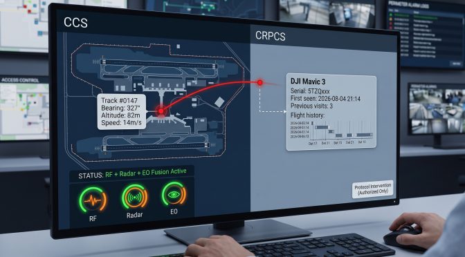
The key difference is what happens after a drone is detected. In CCS, the operator sees a track ID, bearing, and estimated position. In CRPCS, the system also decodes the drone’s radio protocol signature — identifying the make, model, and even the serial number of the aircraft in real time. This is not simply matching a frequency profile against a database. It is parsing the drone’s communication protocol itself to extract identifiers embedded in the signal.

Protocol-level identification changes the operator’s decision framework in several ways. Knowing that the approaching aircraft is a DJI Mavic 3 rather than a generic unidentified drone gives the response team critical operational context: typical flight duration of around 30 minutes, payload capacity of roughly 500 grams, and known behavioral patterns. If the same airframe serial number has been detected at the site before, the system flags it as a repeat visitor and cross-references it against historical track data.

A second capability in CRPCS is the protocol-level control interface. For authorized operators in jurisdictions that permit drone intervention, the platform can command a target aircraft to land or return to its takeoff point through its own communication protocol — a more precise maneuver than broad-spectrum jamming, and one that does not affect nearby communications systems. This capability is available only to law enforcement and national security users operating under applicable legal authority.

CRPCS is the platform of choice for sites with high threat density  —  multiple incidents per month.  And for network deployments where multiple facilities share a common command architecture. The protocol intelligence layer adds value when the response team needs more than a radar blip. They need an aircraft identity and, where authorized, a controlled response.

For a national security agency managing drone threats across eight critical infrastructure sites — power plants, government buildings, data centers — the CRPCS protocol intelligence layer changes the threat assessment workflow. A drone detected at Site A on Tuesday night is logged as a DJI Mavic 3 with serial number 5TZQ-xxxx. When the same serial number appears at Site B on Thursday morning, CRPCS flags it as a correlated event and presents the operator with the full flight history: two previous visits, both at night, both at energy infrastructure sites. The operator now has context that a basic RF track would not provide — this is not a random overflight; it is a pattern. That changes the response posture from routine monitoring to active investigation.

A Side-by-Side Look at the Differences

The two platforms share a common foundation, but their strengths diverge in ways that matter for procurement decisions.

Sensor Integration

CCS integrates RF direction finding, radar, and EO/IR camera feeds from fixed and mobile sensors. CRPCS does the same but adds deeper data fusion — multiple sensors tracking the same drone share correlation data, improving position accuracy and reducing false tracks.

Drone Identification

CCS provides basic signal classification — DJI class, Autel class, unknown. CRPCS delivers model-level and serial-number-level identification through protocol parsing, along with historical track matching across the facility’s entire detection database.

Multi-Site Networking

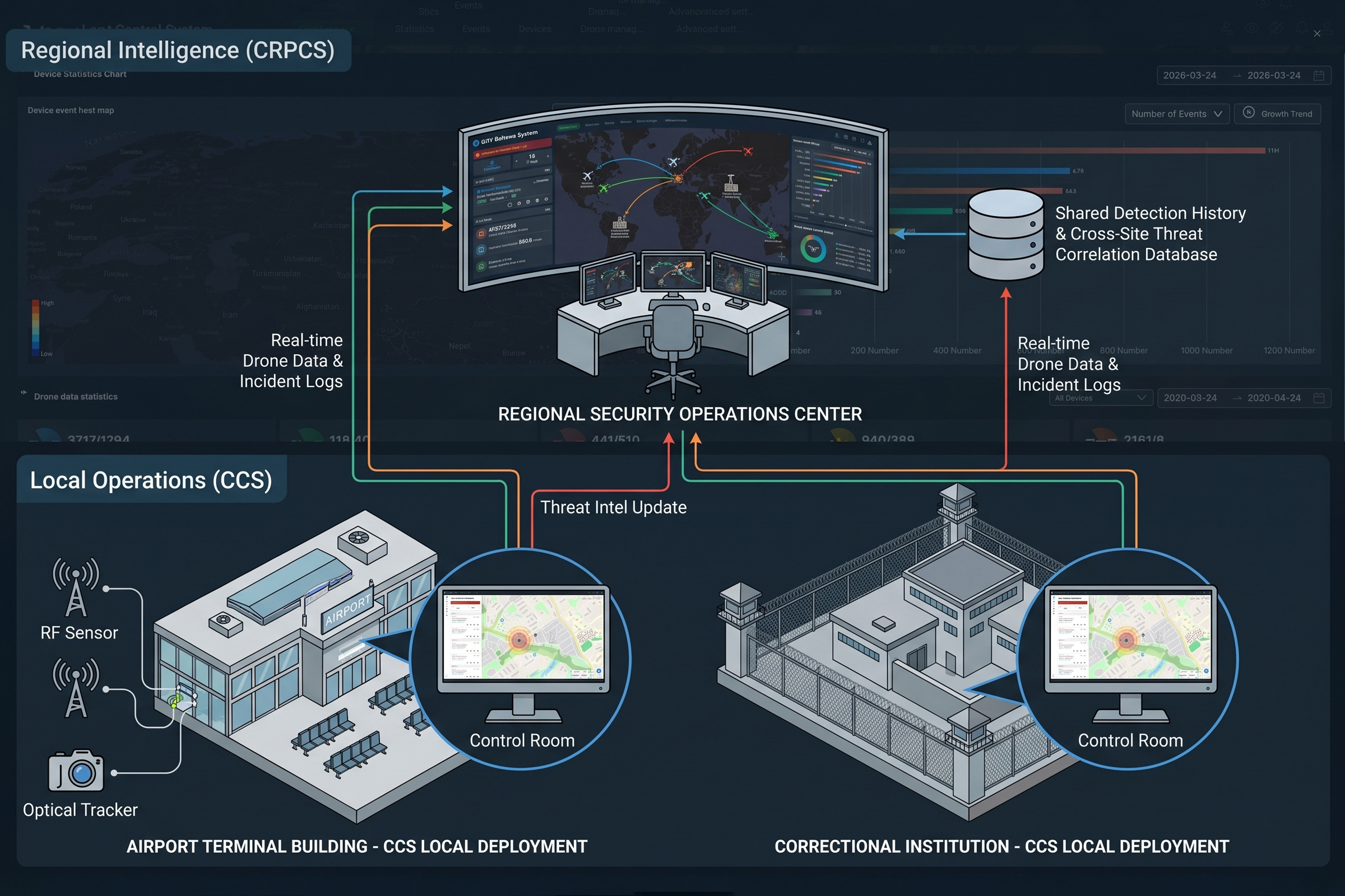
CCS is designed for single-site operation with one control room. CRPCS supports distributed deployments across multiple facilities, with shared threat databases, cross-site alert correlation, and a centralized command view for regional security operations centers.

Operator Workflow

CCS workflow centers on detection, tracking, and optional camera cueing. CRPCS adds the identification layer  —  drone model, serial number, flight history.  And, for authorized users, a protocol-based intervention option that is more surgical than jamming.

Choosing Between CCS and CRPCS: Four Questions That Matter

Rather than a feature checklist, four operational questions tend to point toward one platform.

  1. How Complex Is Your Sensor Topology?

A site with two DF10 Max RF sensors and one VAR300 optical tracker  —  all fixed, all in one location.  Can operate effectively with CCS. When the site adds mobile HDJ 3.0 patrol units, airborne D5-Air platforms on drones, and remotely distributed sensors across kilometers of perimeter, the fusion engine in CRPCS extracts more value from the expanded sensor network.

  1. How Important Is Drone Identification to Your Response?

If the operational need is to know simply that a drone is present and track its position, CCS covers that fully. If the team needs to know which drone  —  including make, model, serial number, and flight history.  Only CRPCS delivers that level of identification. The difference becomes operational when determining whether a drone is a commercial off-the-shelf model flown by an amateur or a repeat intruder tracked across multiple nights.

  1. Are Multiple Sites Being Netted Together?

A single-site installation typically does not need the distributed command architecture that CRPCS supports. When two or more facilities  —  for example, separate airport terminals or a city-wide deployment across multiple critical infrastructure sites.  Need to share real-time threat data; CRPCS provides the backbone.

  1. What Is the Volume of Incidents?

Sites experiencing occasional drone overflights  —  fewer than five confirmed incidents per month.  Can manage effectively with CCS. Where incident volume climbs into the tens per month, the protocol intelligence layer helps operators prioritize threats and track repeat patterns across shifts without losing situational context.

How the Two Platforms Work Together

CCS and CRPCS are not competing products. They sit on the same platform lineage, and many sites begin with CCS and upgrade to CRPCS as their threat profile and sensor network grow.

A common deployment pattern starts with CCS at a single high-risk facility — an airport terminal, a data center, or a correctional institution. As facility teams document drone incidents and build a case for expanded coverage, they add CRPCS at the network level, with individual sites continuing to operate CCS locally. The result is a layered command architecture: CCS for immediate operational awareness at each site, CRPCS for cross-site threat intelligence and protocol-level identification.

A real example from our team’s deployment experience illustrates the staged approach. A national airport authority began drone detection operations at its busiest hub with CCS, integrating two DF10 Max direction-finding units and one T100 dual-spectrum tracker. Over the first six months, the CCS event log documented 23 confirmed drone incursions — an average of nearly one per week. The data gave the authority the evidence it needed to secure funding for expansion to three additional airports. They upgraded the central command architecture to CRPCS, networked all four sites, and added protocol-level identification. The key point: none of this would have happened without the initial CCS deployment generating the threat data that made the case for expansion. Start small, document everything, scale with evidence — that is the CCS-to-CRPCS path in practice.

This staged approach has a practical advantage: the site builds operational expertise on CCS before adding the protocol intelligence layer. Operators learn to interpret drone tracks, assess threat levels, and coordinate responses. When CRPCS is deployed, the team already understands the sensor environment — the new layer adds identification and networking without requiring a re-learning of the basics.

The data collected by both platforms feeds into the same C-UAS workflow: detect, identify, track, and  —  where authorized.  respond. Which platform matters less than having a platform at all? A site with five sensors and no C2 software is less capable than a site with two sensors running CCS.

The Hardware Matters, But the Software Decides

In the C-UAS market, the visible conversation often revolves around sensor specifications: frequency range, detection distance, and bearing accuracy. Those numbers matter — they define what the system can see. But the operational difference between an effective drone defense and a collection of individual sensors is the software layer that connects them.

CCS delivers unified situational awareness for sites that need to bring multiple sensors onto one screen and reduce the time between detection and decision. CRPCS adds protocol intelligence — the ability to not just see that a drone is there, but to know exactly what it is, whether it has been there before, and, where authorized, to intervene through the drone’s own communication protocol.

The right choice depends on the site, the threat profile, and the growth path the organization expects to follow. What is consistent across both platforms is the principle: the sensor network provides the raw data. The command software turns that data into an operational response. Neither works without the other.

How Corrections Facilities Are Fighting Back Against Drone Smuggling

A Growing Problem Above the Walls

In February 2026, Belgian authorities arrested a drone operator attempting to deliver drugs and a weapon into Lantin Prison — the third major incident of its kind in the country that year. Across Europe, North America, and Southeast Asia, the same pattern repeats: unmanned aerial vehicles are being used as delivery vehicles for contraband, moving narcotics, SIM cards, and sharp objects into facilities where detection from the ground has historically been nearly impossible.

The numbers back up the anecdote. A 2025 survey by the European Organisation of Prison and Correctional Services found that 43 percent of member facilities had experienced at least one confirmed drone incursion in the preceding twelve months, up from 27 percent in 2022. In the United Kingdom, HM Prison Service reported 178 drone-related incidents across its estate in 2025 alone — a figure that doubled in three years. Across the Atlantic, a South Carolina prison contraband ring broken up in March 2026 had used drones to drop packages containing narcotics, cell phones, and bladed instruments into multiple facilities over an 18-month period, generating more than $2 million in illicit sales before detection.

For corrections administrators, the question is no longer whether drone intrusions will happen. It is how to catch them before the package lands.

The variety of contraband moving through prison airspace reflects the financial incentives underwriting the drone supply chain. A single cell phone smuggled into a maximum-security facility can sell for ten to twenty times its retail price. Packages of synthetic drugs delivered by drone command premiums that make street-level dealing look low-margin by comparison. The economics will not reverse themselves — as long as inmates can pay, outside operators will find ways to deliver. The question for corrections security is not how to eliminate the demand, but how to make delivery too risky to attempt.

Why Drones Are Harder to Stop Than They Look

Most small commercial drones  —  including popular models from DJI.  Operate at low altitudes, below the coverage of conventional perimeter security. They are quiet enough to blend with ambient noise. And they can be flown by someone outside the perimeter wall entirely, beyond the reach of in-house security staff.

The solution is not one technology. It is a layered approach that starts with detection, moves to locating the operator, and ends with interdiction before landing.

This is where radio frequency detection has an edge over optical or radar-based systems in the corrections context: it can detect and classify a drone signal before the aircraft is visually identifiable, giving staff the reaction time they need.

Detection: Knowing a Drone Is There Before It Lands

Fixed-Site RF Detection — DF10 Max and D5-Air

The DF10 Max is a fixed-site direction-finding system that monitors radio frequencies from 100 MHz to 8 GHz — a range that covers the command-and-control links, video downlinks, and remote controller signals used by most commercial drones. Its detection range extends to 8 kilometers, with a direction-finding accuracy of 5 degrees RMS or better, allowing security staff to pinpoint a drone’s position and track its path in real time.

For facilities that need to cover large perimeters or irregular terrain, the D5-Air extends that capability into the air. Designed for mounting on UAV platforms, the D5-Air operates in the 400 MHz to 6 GHz band and achieves detection ranges of up to 5 kilometers. When paired with a ground-based DF system, it creates a three-dimensional picture of the airspace: the drone’s position on approach, the direction from which it was launched, and the probable operator location.

Both systems are passive — they receive signals without emitting anything, which means they can operate continuously without interfering with the facility’s own communications or triggering regulatory concerns.

Mobile Patrol — HDJ 3.0 for Field Deployment

Not every correction threat happens at the perimeter wall. Mobile patrol teams covering the outer grounds, visiting areas, or responding to incidents away from fixed infrastructure need a system that moves with them.

The HDJ 3.0 is a handheld detection and direction-finding unit built around a dual hot-swappable battery system that delivers more than three hours of continuous operation in the field. Its operating band spans 400 MHz to 6 GHz, covering the same drone frequency ranges as fixed-site equipment. A built-in 5.5-inch display provides real-time bearing information, giving patrol officers directional guidance toward an active drone threat. Direction-finding accuracy is rated at 10 degrees RMS or better, sufficient to track a moving aircraft to its approximate launch point.

The dual-battery design addresses a real operational pain point for corrections patrols: most handheld drone detectors run on internal batteries that cannot be swapped in the field. When the battery dies, the patrol loses detection coverage until the unit is recharged — a gap that can last hours. With HDJ 3.0’s hot-swappable packs, a patrol officer can carry a spare battery in a belt pouch, swap it in seconds, and maintain continuous coverage across a full eight-hour shift.

For facilities that run rotating patrol schedules across large sites, the HDJ 3.0 brings the same detection capability to mobile teams that fixed infrastructure provides to static positions.

From Detection to Interdiction

Detection only solves half the problem. Corrections administrators need a clear response protocol that distinguishes between a drone passing overhead  —  which may not be targeting the facility.  And one that is descending toward a delivery point.

This distinction — overflight versus delivery — is operationally critical. Most drone incursions near prisons are overflights that never descend toward the facility. They may be hobbyists flying near a restricted zone, survey drones operating in the area, or commercial delivery drones on approved routes. Treating every overflight as a threat burns operator attention and response resources. A good detection system reduces false alarms by combining frequency classification — distinguishing a DJI consumer drone from a fixed-wing mapping UAV — with bearing data that shows whether the drone’s flight path is converging on the facility or simply crossing the surrounding airspace.

A layered system that combines RF detection with real-time mapping helps officers make that call faster. When the DF10 Max or D5-Air picks up a drone signature, the bearing data feeds directly into a facility’s command platform, overlaying the threat onto a map of the grounds. Officers can see the drone’s approach vector and determine whether it is consistent with a delivery attempt.

Where active interdiction is authorized and legally available, the next layer is jamming — disrupting the drone’s command-and-control link to bring the aircraft down in a controlled location. RF jamming systems work by overwhelming the frequency band the drone uses to communicate with its controller, forcing a loss of signal and triggering the aircraft’s return-to-home or landing protocol.

The legal framework for jamming varies by jurisdiction. In most countries, active jamming by private parties is restricted or prohibited. RF detection and operator location  —  the capabilities offered by the DF10 Max, D5-Air, and HDJ 3.0 — are widely permissible for facility security teams and law enforcement.

Building a Corrections C-UAS Response Plan

A drone incident response plan for a corrections facility should address three phases.

Phase 1: Detection and Classification (0–30 seconds)

RF detection systems identify the drone’s radio signature, classify it against a known drone database, and generate an alert. At this stage, the system is passive — no action is taken, and no signals are emitted.

Phase 2: Tracking and Operator Location (30 seconds–2 minutes)

Direction-finding data tracks the drone’s flight path and triangulates the likely operator position. This information goes to the command center and to field officers. If the drone is descending toward the facility, this is the decision window.

Phase 3: Response and Evidence Collection

Once a delivery attempt is confirmed, the response depends on local authorization. RF detection logs  —  including frequency, signal strength, bearing, and timestamps.  Serve as evidence for subsequent prosecution. In jurisdictions where active countermeasures are authorized, the jamming system engages.

Across all three phases, the common thread is radio frequency intelligence. Optical confirmation comes second; the radio signature comes first.

What Corrections Facilities Need to Know Before Buying

The buying decision for a corrections facility is different from an airport or a stadium in one important respect: the perimeter is both the defense line and the target. At a stadium, a drone overflight is an intrusion. At a prison, the drone is there to make a delivery — it will intentionally cross the wall, descend into the yard, and drop a payload before climbing back out. The detection system needs to be sensitive enough to catch the drone on approach, not just on arrival. By the time a drone is visible above the yard, the package has already been released.

A few practical considerations come up repeatedly in conversations with corrections security teams.

Coverage geometry matters more than raw range. An 8-kilometer detection system mounted at a single point on a large perimeter will still have blind spots. The DF10 Max is best deployed at multiple points across a facility’s perimeter, with D5-Air airborne assets filling coverage gaps over irregular terrain.

Drone signature libraries need to stay current. The RF detection systems used in correctional environments should maintain an active database of commercial drone models  —  including DIY and FPV builds — to avoid false negatives. A database covering fewer than 200 models will miss a meaningful portion of the threats likely to appear at a modern corrections facility.

Integration with existing command platforms reduces response time. Systems that can push drone alerts into the same interface officers already use for camera feeds and perimeter alarms eliminate the context-switching that slows real-world responses.

The Regulatory Angle Is Still Developing

As of mid-2026, no country has a fully settled legal framework for drone interdiction in correctional environments. Several European jurisdictions have updated their civil aviation regulations to give prison authorities or law enforcement limited counter-drone powers. The United States has moved more slowly, with most active countermeasures still requiring law enforcement coordination.

What is consistent across jurisdictions is the legitimacy of passive detection. RF monitoring, direction finding, and operator location are widely accepted as lawful security measures for critical infrastructure and correctional facilities. This makes the detection and tracking layer  —  not the interdiction layer.  The right starting point for any facility building out its C-UAS capability.

Getting Started: Three Priorities

For corrections administrators evaluating drone detection systems, the three most important near-term actions are:

First, map the airspace above and around the facility to understand current coverage gaps. Most facilities find that their camera systems and perimeter sensors leave the airspace above 10 meters largely unmonitored.

Second, establish a drone detection baseline with passive RF systems before adding active countermeasures. This gives the facility a documented detection record and a framework for evaluating future interdiction options.

Third, connect detection data to the existing command platform. A drone alert that requires an officer to open a separate application is a drone alert that arrives too late.

Vehicle-Mounted Drone Defense: Mobile Protection for Convoys and Temporary Sites

Most counter-drone systems are designed to sit in one place and protect a fixed perimeter. That works for airports, stadiums, prisons, and power plants. It does not work for anything that moves. A VIP convoy is driving between two cities. A temporary command post set up at a disaster response site. A mobile inspection team moving between remote infrastructure locations. In these scenarios, the protected asset does not have a fixed address. The counter-drone system needs to move with it.

Vehicle-mounted drone defense solves this by putting detection and jamming capability on a vehicle that travels with the asset it protects. The concept is straightforward. A vehicle carries a sensor suite that scans for drone signals, identifies threats, and jams hostile drones, all while moving at highway speeds. The vehicle creates a protection bubble that moves with the convoy. When the vehicle stops, the protection bubble becomes a temporary fixed-site defense. When it moves, the bubble moves.

The physics of detecting drones from a moving vehicle

Detecting a drone from a stationary sensor is hard because of terrain, multipath, and signal attenuation. Detecting a drone from a vehicle moving at 80 kilometers per hour adds two more challenges. First, the vehicle’s own motion shifts the apparent angle of arrival of every signal it receives. The sensor is moving relative to both the drone and the remote controller, so the raw bearing data changes continuously even if the drone is stationary. Second, the vehicle itself is a noise source. Engine electronics, onboard communication systems, and the metal vehicle body all contribute to the electromagnetic environment the sensor must operate within.

The VM system addresses the motion challenge with signal processing that compensates for the vehicle’s movement in real time. It achieves direction-finding accuracy of 3 degrees RMS for a hovering target and 10 degrees RMS for a moving target, even while the vehicle is in motion. For comparison, these are the same accuracy specifications as LZ TECH’s fixed-site DF Series sensors. The vehicle’s speed, measured by its own GPS and inertial sensors, is subtracted from the incoming bearing data so the angle-of-arrival calculation reflects the drone’s true position rather than the sensor’s movement.

The detection band spans 30 MHz to 6 GHz, covering the same full range as the fixed-site systems. Detection range extends to 3 kilometers from the vehicle’s position. A drone approaching the convoy from 3 kilometers away is detected while the vehicle still has approximately two minutes of driving time before the drone closes the distance, assuming the drone is moving at 20 meters per second and the vehicle is traveling at 80 kilometers per hour.

Creating a moving protection bubble

The protection bubble concept describes an area around the vehicle where the VM system detects, identifies, and can jam drones. The size of the bubble varies with speed, terrain, and the type of drone being detected. In open terrain at moderate speed, the detection bubble extends to roughly 3 kilometers. The jamming bubble is smaller, covering the immediate airspace above and around the protected asset. The vehicle’s motion extends the bubble in real time, so a convoy of vehicles with multiple VM systems creates overlapping bubbles that cover the entire convoy length.

The jamming capability is configured for the specific operational environment. The VM system outputs across eight bands: 400 MHz, 800 MHz, 900 MHz, 1.2 GHz, 1.4 GHz, 2.4 GHz, 5.2 GHz, and 5.8 GHz. Each band is individually configurable, so the operator can activate only the frequencies that the detected drone is using while leaving other bands clear for the convoy’s own communications. The jamming is omnidirectional from the vehicle, which means the bubble is a sphere around the vehicle rather than a directional beam. For a convoy moving through open terrain where collateral interference is not a concern, omnidirectional coverage is simpler and more reliable than directional jamming that must be constantly re-aimed as the vehicle turns and changes speed.

From convoy protection to temporary site defense

The same vehicle that protects a moving convoy becomes a fixed-site defense system the moment it parks. At a temporary command post, a disaster response staging area, or a field inspection site, the vehicle stops and the VM system continues operating. The detection bubble now covers a fixed circle around the parked vehicle. Multiple vehicles can be spaced to create overlapping coverage across a temporary site of any size.

This dual-mode capability reduces the logistics burden for organizations that need both mobile and temporary fixed-site protection. Instead of deploying a convoy protection vehicle for the drive and a separate fixed-site system for the destination, the same VM-equipped vehicle covers both phases of the operation. The system transitions from mobile to stationary operation with no reconfiguration. The detection algorithms adjust automatically when the vehicle’s GPS reports zero speed.

The VM system’s environmental specifications support this dual-use profile. It is rated IP66 for protection against dust and high-pressure water jets. The operating temperature range spans -40 to +60 degrees Celsius. These ratings are not marketing specifications. They mean the system can be deployed in desert heat, in heavy rain, and in freezing conditions, without taking the vehicle offline for weather. The same vehicle that drove through a sandstorm at 40 degrees Celsius continues to provide drone detection when it parks.

A typical convoy protection deployment

A representative deployment scenario illustrates how the pieces fit together. A three-vehicle convoy is moving from a headquarters building to a field inspection site 120 kilometers away. The lead vehicle carries a VM system with the detection and jamming suite integrated into a roof-mounted enclosure. The middle vehicle carries the protected principals. The trail vehicle provides rear security.

As the convoy departs the headquarters, the VM system begins scanning the 30 MHz to 6 GHz band. Two minutes into the drive, it detects an unknown drone signal at 2.4 GHz, approximately 2.5 kilometers ahead and slightly to the right of the convoy’s direction of travel. The detection data identifies the drone as a DJI Mavic 3, provides the drone’s GPS coordinates and altitude, and plots the remote controller position on a map. The convoy commander evaluates the information: the drone is at 120 meters altitude and its position suggests it is mapping a construction site adjacent to the highway, not tracking the convoy. The commander logs the detection and continues. The VM system records the encounter for post-mission analysis.

Twenty kilometers from the destination, a second detection appears. A smaller drone, identified as a custom FPV quadcopter, is approaching from the convoy’s left at 15 meters altitude, heading directly toward the middle vehicle. The convoy commander activates the jamming system on the 2.4 GHz and 5.8 GHz bands. The FPV drone loses its video and control link and falls to the ground 800 meters from the convoy. The convoy continues without stopping. The entire sequence, from detection to neutralization, takes under 30 seconds.

Where vehicle-mounted systems fit in the broader C-UAS field

Vehicle-mounted systems do not replace fixed-site installations. They complement them. A permanent facility that needs 24-hour protection is better served by a fixed grid of DF Series sensors, D5-B TDOA nodes, and electro-optical verification systems. A convoy, a temporary site, or a mobile inspection team that has no fixed address needs a system that moves. The VM fills that gap. Its specifications parallel the fixed-site product line in detection range, frequency coverage, and accuracy. The difference is the form factor and the motion compensation that makes mobile operation possible.

For organizations that operate across distributed sites connected by road, the combination of fixed-site protection at each facility and vehicle-mounted protection for the road segments between them closes the coverage gap. The drone threat does not respect the property line between the perimeter fence and the highway. A vehicle-mounted system ensures the protection extends to wherever the asset goes, not just to wherever the asset parks.

Standalone Systems vs. OEM Modules: An Integrator’s Guide to Drone Defense

A system integrator adding drone defense to a security platform faces a real fork in the road. One path is to pick a ready-made piece of hardware, plug it in, and hand the end user the controls. The other is to pull the detection engine out of that hardware, embed it inside the integrator’s own platform, and present a unified experience under a single brand. Both paths lead to a working solution. The difference is in who owns the integration, who owns the brand, and what the total cost looks like after the tenth deployment.

This article walks through both paths with concrete product examples. For the standalone path, three LZ TECH systems serve as reference points: the HJ1 handheld unit for portable security, the J3 fixed-site system for permanent installations, and the JV-1 for sites that face a high proportion of FPV and custom-built drones. For the OEM path, the D-MB Mini detection module and its larger siblings in the OEM module family show what embedded integration looks like.

Path A: Pick a product and go

The standalone approach is the simpler starting point. A self-contained drone defense device arrives in a flight case, mounts on a pole or sits in a vehicle, connects to power and network, and begins operating. The integrator does not write code. The end user gets a separate interface for drone defense alongside their existing security platform. Implementation takes days, not months.

Three LZ TECH systems illustrate the range of what a standalone product can look like.

HJ1: Handheld, portable, single-operator

The HJ1 is a handheld drone defense system designed for one person to carry and operate. It weighs 6.5 kilograms with its battery installed, and its built-in handle and strap ports make it practical for a security officer to carry on patrol or deploy at a checkpoint. The device covers six frequency channels spanning the bands most commonly used by commercial drone communication and navigation links, from 800 MHz through 5.8 GHz. Its high-gain directional antenna array focuses its output on the target drone rather than broadcasting across the entire area, which matters when operating near other RF-dependent equipment. Response time from trigger to full output is under five seconds, measured as an RMS value across operational conditions.

The HJ1 is battery-powered with a field-replaceable lithium-ion pack, giving roughly half an hour of continuous operation on a single charge. It charges from zero to full in under two hours. The IP54 rating means it handles dust and splashing water, and it operates from minus 25 to 55 degrees Celsius. For deployments that need detection before action, the HJ1 includes an expansion holder and interface for an external handheld detection module, which adds drone identification and alarm capabilities to the jammer-only baseline.

For an integrator serving event security, VIP protection details, or rural patrol teams, the HJ1 is the kind of device that a single operator can deploy from a vehicle without tools. The integration story is simple: hand the device to the security team, provide basic training, and the capability is live.

J3: Fixed-site, 360-degree, always on

The J3 is a stationary drone defense system built for permanent installation. It uses eight independent channels to cover the full range of frequencies used by commercial drones for video transmission, remote control, and navigation, from 430 MHz through 5.8 GHz. The omnidirectional antenna array covers 360 degrees horizontally and plus or minus 90 degrees vertically. There are no blind spots.

The J3 supports precise selective targeting when paired with an external detection system. It can address a specific threat drone in an airspace that also contains friendly or authorized drones, rather than affecting everything in the sky. It also supports network integration with radar, electro-optical, and RF detection equipment, enabling an unattended detect-and-respond workflow. Response time is under five seconds.

Environmental resilience is one of J3’s stronger design points. IP66 protection keeps out dust and high-pressure water jets. The operating temperature range spans minus 40 to 55 degrees Celsius. It runs on AC power with low standby draw, and the flight-case packaging makes transport and installation straightforward for a fixed-site deployment team. At roughly 35 kilograms for the device itself, the J3 is not portable in a patrol-bag sense. It is meant to be mounted, connected, and left to run.

For an integrator serving airports, correctional facilities, or government buildings, the J3 is the permanent-installation option. Mount it, network it, and it becomes part of the facility’s infrastructure.

JV-1: Purpose-built for FPV and custom drones

The JV-1 addresses a specific problem that generic drone defense systems can miss. FPV racing drones and custom DIY builds often operate on frequency bands outside the standard commercial drone channels. The JV-1 targets these non-standard links specifically: the TBS Crossfire and ExpressLRS protocols at 868 and 915 MHz, analog FPV video feeds at 1.2 GHz, and the wider 5.1 to 5.9 GHz range used by high-power digital video systems. It uses a combination of narrowband and frequency-hopping techniques to match the agile signaling that FPV drones employ.

The JV-1 has a unique capability that is worth noting for integrators who work with security teams that need visual confirmation. When connected to a radio detection system, the JV-1 can display the drone’s first-person camera feed directly in the operator’s software interface. The security officer sees what the drone pilot sees. It can also transmit custom text or image alerts to FPV goggles and video receivers in the area, which has operational utility for communicating with an unknown drone operator.

The JV-1 is a fixed-site device with 360-degree omnidirectional coverage, IP66 protection, and an operating range from minus 40 to 60 degrees Celsius. It weighs under 25 kilograms without its antennas and ships in flight cases. It supports fixed, vehicle-mounted, and mobile deployment configurations. For an integrator whose customer base includes prisons or critical infrastructure sites that have reported FPV drone incursions, the JV-1 is the specialized tool for a specialized threat.

Path B: Embed the detection engine

The OEM module path takes a different approach. Instead of buying a complete product, the integrator buys a compact hardware unit that contains an RF front end and an onboard processor running the detection software. The module detects drones, identifies the model and protocol, and outputs structured data through an API. It does not include a case, an antenna array, a user interface, or a dashboard. It provides a data feed and leaves everything else to the integrator’s platform.

LZ TECH’s OEM module family follows this model. The modules cover 70 MHz to 6 GHz, using the CRPC protocol analysis engine to decode drone communication and identification protocols. The structured data output from the module includes the detected drone model, its serial number or identification marker, GPS coordinates, altitude, speed, heading, and the position of the remote controller. The integrator’s software ingests this stream through the API and renders it in whatever form the platform’s interface requires.

The D-MB Mini is the compact entry point in this family. It is designed for space-constrained platforms: portable security devices, compact sensor nodes, and handheld equipment where the module must fit inside an existing chassis. Larger module variants add direction-finding capability for platforms that need bearing data alongside detection, and higher sensitivity for fixed-site installations that require the longest possible detection range. All variants run the same CRPC detection core, so an integrator who qualifies one module can add new deployment profiles by selecting a different module variant rather than starting a new integration project.

The integration investment is front-loaded. The integrator’s development team builds the user interface components, the alerting pipeline, and the data mapping from the module’s API output into the platform’s internal data model. Once complete, adding drone detection to additional deployments is a configuration change, not a hardware procurement. The CRT display, the alert rules, the operator workflow, and the audit trail are all native to the integrator’s platform. It is delivery of a native capability rather than the bolt-on of a third-party product.

How the two paths fit together in practice

A representative deployment shows why the choice between standalone and OEM is not either-or for many integrators. Consider a security company that operates a command-and-control software platform for correctional facilities. They have twenty prison sites under contract. At each site, they need drone detection and defense. They also sell their platform to new customers who have no existing drone security infrastructure.

For the core detection capability that rolls out to all twenty sites and every new customer, the OEM module path makes sense. Embed the detection engine once, spread the integration cost across all deployments, and present a unified interface to every customer. The integrator owns the capability. For the defense hardware at each site, they might deploy a J3 mounted on a watchtower, connected to the platform through the network integration interface. The platform receives detection data from the embedded OEM module, correlates it with the J3’s status, and presents a single workflow to the operator. The detection is native to the platform. The defense layer is a best-in-class standalone system that the platform manages as a networked device.

At a site that reports FPV drone intrusions, they add a JV-1 alongside the J3. The threat profile determines the defense hardware. The integration depth determines the operator experience. Both can be chosen independently.

The decision framework

Five questions cut through the standalone-versus-OEM trade-off. They are the same questions regardless of which specific products the integrator evaluates.

Question one: What is the deployment timeline? A single site going live next month points toward a standalone device like the HJ1 or J3. A platform capability shipping to a growing customer base over years points toward OEM module integration.

Question two: What is the expected deployment volume? Below roughly five to ten sites, the standalone product often wins on total cost because the integration investment has not yet amortized. Above that, the OEM module becomes the lower total cost. The crossover point depends on the integrator’s internal engineering costs, but the logic is the same.

Question three: How tight does the integration need to be? If drone defense alerts must appear on the same map as camera feeds, access control events, and perimeter alarms, the OEM module delivers native integration. A standalone product will always require the operator to look at a separate interface or a separate pane within the platform that was bolted on rather than built in.

Question four: Who owns the end customer? If the integrator’s value proposition depends on single-vendor accountability and consistent brand experience across all security domains, embedding OEM modules keeps everything behind the integrator’s brand. The standalone path puts a visible third-party label on the drone defense capability.

Question five: What is the long-term supplier flexibility requirement? If the integrator needs the ability to swap detection or defense hardware suppliers with minimal end-customer disruption, the OEM module architecture provides that flexibility through a defined API layer. The standalone approach creates a tighter coupling to a specific product’s lifecycle and roadmap.

The products are real. The choice depends on you

The HJ1, J3, JV-1, and the D-MB Mini are not concept designs. They are products with shipping histories, compliance certifications, and field hours. The HJ1 has been carried by security teams at outdoor events and sensitive facilities. The J3 is mounted on rooftops and perimeter walls. The JV-1 addresses a threat category that generic systems miss. The D-MB Mini runs inside partner platforms that bear other companies’ brand names.

The integrator’s job is to match the product to the deployment profile. The handheld for the roving patrol. The fixed site for the permanent perimeter. The FPV specialist for the facility that sees custom drones. The OEM module for the platform that ships to dozens of sites under a single brand. There is no single correct answer across all scenarios. There is a correct answer for each scenario. The framework is the tool for finding it.