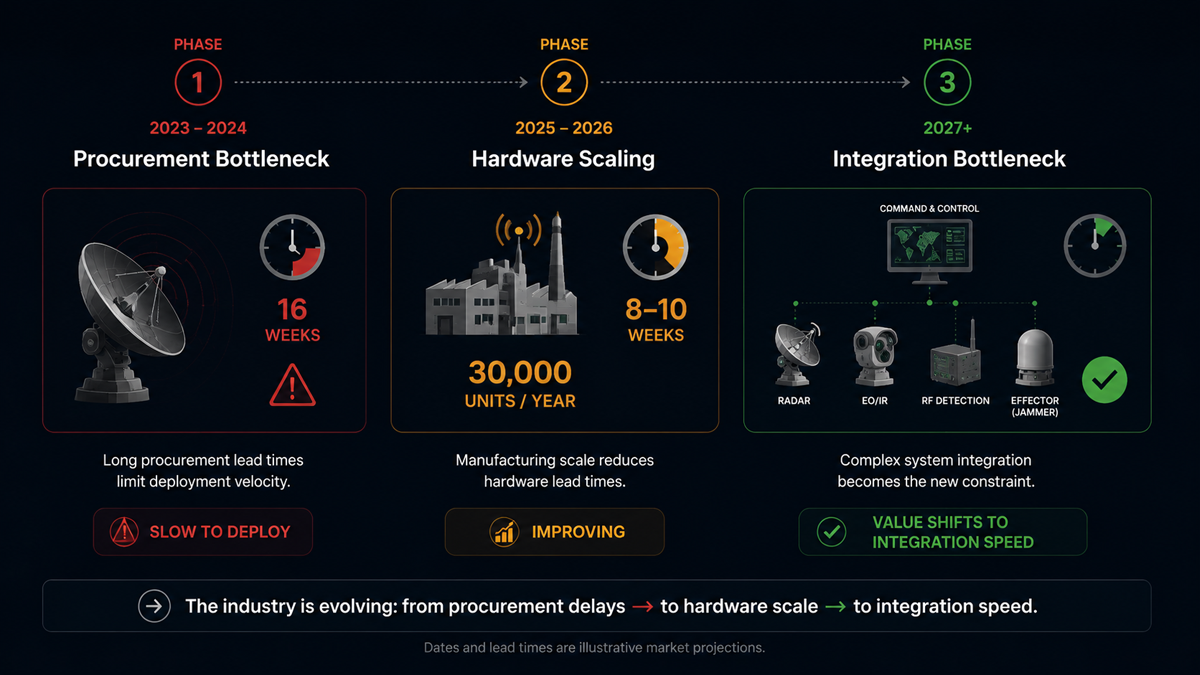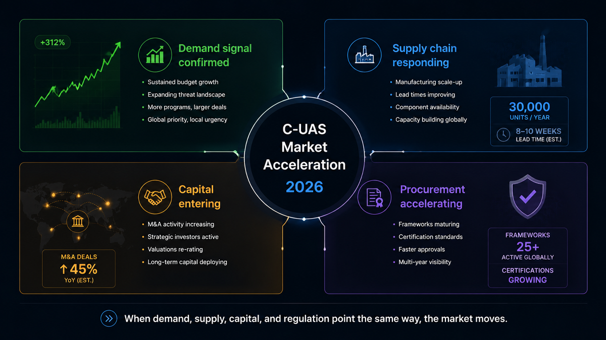
Four Signals the Counter-Drone Market Is Entering a Procurement Phase in 2026

For years, the counter-drone industry has been described as emerging, growing, and on the verge of a breakout. Those descriptions were accurate for a market where most activity consisted of pilot programs, trial deployments, and small-scale procurements by early-adopter government agencies. In 2026, the evidence suggests the market is no longer emerging. It is accelerating into a phase of institutional procurement and industrial scale.

Four signals from the first half of 2026 make the case. They come from different corners of the industry: a publicly traded pure-play counter-drone company, a radar manufacturer committing to volume production, a major acquisition by a public safety technology company, and a multilateral defense procurement framework. Each signal is meaningful on its own. Together, they describe a market that has moved from pilots to programs.

Signal 1: DroneShield’s Revenue Growth Shows Institutional Procurement at Scale

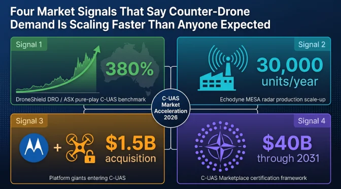
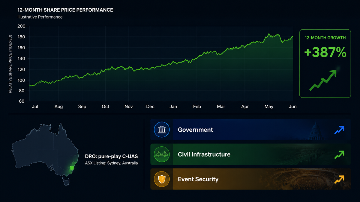
DroneShield, the Australian counter-drone company listed on the Australian Securities Exchange, has reported significant revenue growth over the past several years. The company’s trajectory is notable because it is one of the few pure-play counter-UAS companies with publicly available financial data. Its growth rate provides a window into how quickly government procurement budgets for counter-drone systems are expanding globally.

The company’s revenue has grown at triple-digit percentage rates in recent reporting periods. This is not the growth profile of a company winning a handful of evaluation contracts. It is the profile of a company converting pilot programs into recurring procurement orders. Government customers that previously bought a few units for testing are now ordering systems for operational deployment across multiple sites and, in some cases, across multiple branches of their security forces.

The pattern is consistent across DroneShield’s geographic markets. The company has reported contracts in North America, Europe, the Middle East, and the Asia-Pacific region. The diversity of its customer base suggests that the shift from evaluation to procurement is not limited to one country or one type of end user. It is a global phenomenon.

For the broader counter-drone industry, DroneShield’s financial results serve as a public benchmark. If the only pure-play public company in the sector is growing at triple-digit rates, it strongly suggests that privately held competitors are experiencing similar demand. The rising tide is lifting multiple companies, not just one.

What makes this signal particularly meaningful is that government procurement cycles are slow by nature. A defense or security agency typically takes 12 to 24 months to move from initial evaluation to a signed procurement contract, and another 6 to 12 months to receive and deploy equipment. The growth that DroneShield is reporting now reflects procurement decisions that were initiated two to three years ago. If those early decisions are now converting to revenue at scale, the procurement pipeline for the next two to three years is likely even larger, because the number of agencies that have begun evaluation programs has only increased since then.

Signal 2: Echodyne’s 30,000-Unit Radar Factory Signals Industrial-Scale Production

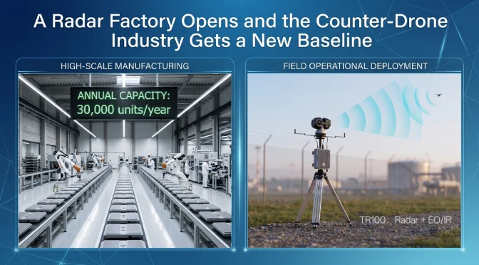
As discussed in more detail in our separate analysis of the TR100 integrated radar platform, Echodyne opened a new production facility in 2026 with an annual capacity exceeding 30,000 MESA radar units. The MESA radar is a compact phased-array system used extensively for drone detection, perimeter security, and border surveillance applications.

A 30,000-unit annual capacity is not a facility sized for boutique defense programs that order radar systems in dozens or low hundreds. It implies that the manufacturer expects demand at a scale that did not previously exist for this class of sensor. For comparison, a typical large defense radar program might order 200 to 500 units over a five-year period. Thirty thousand units per year is two orders of magnitude larger than that.

The investment in volume production capacity is a bet that counter-drone radar will become standard equipment at critical infrastructure sites worldwide, not a specialized capability reserved for high-value military installations. If that bet is correct, the addressable market for this class of sensor will expand dramatically within the next several years.

The factory expansion also has implications for unit economics. Volume production drives down per-unit cost through manufacturing efficiency, supply chain optimization, and amortization of fixed costs over a larger production base. Cheaper radar units expand the addressable market further by making the technology accessible to budget-constrained customers such as municipal police departments, private security firms, and smaller critical infrastructure operators. This creates a virtuous cycle: more production lowers unit cost, which expands the market, which supports more production.

For counter-drone system integrators like LZ TECH, the availability of more affordable radar sensors from multiple suppliers is a positive development. It means that integrated detection systems can be priced at levels that a broader range of customers can afford, accelerating the overall market growth that benefits the entire industry.

Signal 3: Motorola Solutions Acquires D-Fend Solutions for Approximately $1.5 Billion

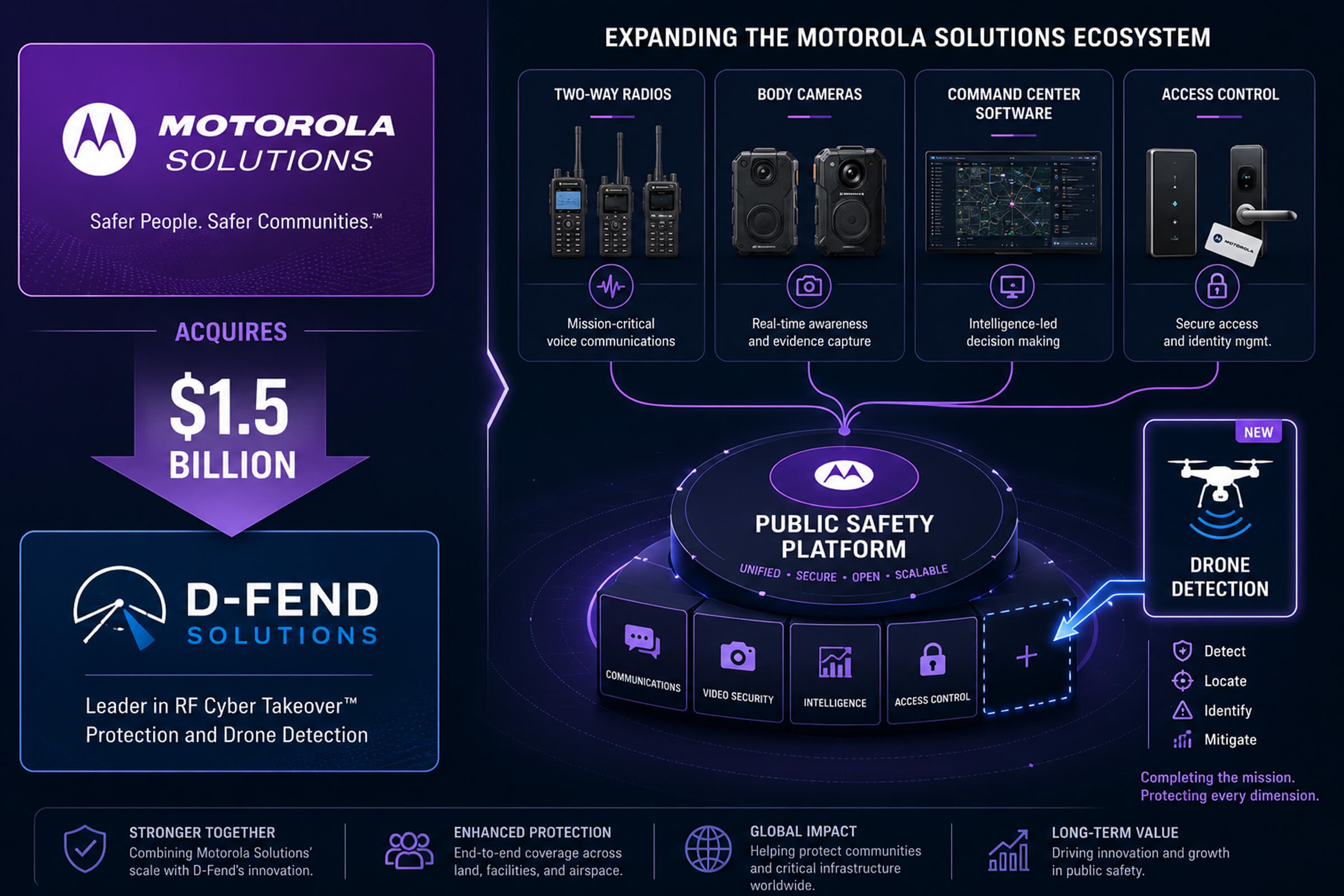
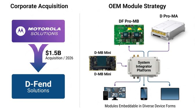
In June 2026, Motorola Solutions announced the acquisition of D-Fend Solutions, an Israeli counter-drone company known for its radio-frequency cyber-takeover technology, for approximately $1.5 billion. This is the largest acquisition in the counter-drone sector to date, and it carries several implications for the market.

First, the acquirer matters as much as the price. Motorola Solutions is a public safety and enterprise security company, not a defense prime contractor. Its customer base consists of police departments, fire services, airports, utilities, and corporate security teams. Motorola sells two-way radios, body cameras, command-center software, and video security systems to thousands of public safety agencies worldwide. The decision to acquire a counter-drone company signals that Motorola sees drone threats as a mainstream public safety problem that its existing customers need to address, not a niche military concern.

Second, the $1.5 billion valuation demonstrates that the financial market now places counter-drone technology companies in the same category as established security technology firms. A billion-dollar acquisition in this sector would have been considered unlikely even three years ago. Today, it has happened. This changes how investors, potential acquirers, and company founders think about the value of counter-drone technology businesses.

Third, Motorola’s distribution network is one of the most extensive in the public safety industry. The company has direct sales relationships with thousands of law enforcement agencies, airport authorities, and critical infrastructure operators across more than 100 countries. D-Fend’s counter-drone technology, combined with Motorola’s sales channels and existing customer relationships, could accelerate the adoption of counter-drone systems by local and regional agencies that have not previously had practical access to this class of equipment.

Fourth, the acquisition signals that counter-drone technology is being absorbed into the broader public safety technology stack. Rather than existing as a standalone discipline with specialized vendors, drone defense is becoming one module within an integrated security platform. Motorola’s command-center software, video management systems, and communication platforms will likely integrate D-Fend’s drone detection and mitigation capabilities, creating a unified security operations interface that includes counter-drone as a standard feature.

Signal 4: NATO’s $40 Billion C-UAS Marketplace Framework

NATO has established a Counter-UAS Marketplace framework with a reported total value of approximately $40 billion. The framework is designed to streamline procurement of counter-drone systems across NATO member states, reducing the administrative overhead of individual national procurement programs and enabling interoperability between allied counter-drone systems.

The significance of this framework extends well beyond the headline dollar figure. It represents a formal recognition at the alliance level that counter-drone capability is now a baseline requirement for modern military forces, comparable to armored vehicles, communication systems, or electronic warfare equipment. A multilateral procurement framework of this size would not be established for a capability that NATO considered experimental or optional.

The framework approach addresses a long-standing problem in defense procurement: fragmentation. Historically, each NATO member state has procured counter-drone systems independently, using its own requirements, its own testing standards, and its own contract vehicles. This results in a patchwork of incompatible systems that cannot share data, cannot coordinate responses, and cost more to acquire and maintain because each national program bears its own overhead.

A centralized marketplace framework solves these problems in several ways. It establishes common technical standards that all participating systems must meet. It creates a pre-qualified vendor list that reduces the procurement timeline for individual member states. It drives interoperability by requiring that all systems procured through the framework can exchange data and coordinate operations. And it aggregates demand, giving NATO member states collective purchasing power that individual nations cannot achieve alone.

For counter-drone manufacturers, a procurement framework of this size creates a structured and predictable market. Companies that can meet NATO’s technical and interoperability requirements gain access to a pipeline of orders across multiple member states. Instead of competing separately in 30 different national procurement processes, they qualify once and are listed for all participating nations. This dramatically reduces the sales cost and timeline for accessing NATO markets.

The framework also encourages investment in research and development. A company that knows it has a clear path to market for a system that meets NATO standards is more likely to invest in developing that system. The framework reduces the risk that a technically superior product will fail commercially because the manufacturer could not manage dozens of separate national procurement bureaucracies.

What These Four Signals Mean Collectively

Viewed individually, each of these signals could be dismissed as a single data point. A company reports strong revenue. A manufacturer expands a factory. Another company gets acquired by a larger player. A military alliance sets up a procurement framework. Any one of these events, on its own, is interesting but not conclusive.

Viewed together, they describe a market that is crossing an important threshold. The counter-drone industry is moving from a collection of technology demonstrations and small-scale deployments to an established sector with institutional buyers, billion-dollar valuations, volume manufacturing, and multilateral procurement structures. The market infrastructure that supports large-scale industrial activity is being built: standardized requirements, pre-qualified vendor lists, interoperable architectures, and distribution channels that reach thousands of end-user organizations.

The practical implication for end users is that counter-drone equipment is becoming more accessible, more standardized, and more interoperable. The days of every deployment being a bespoke integration project are numbered. The practical implication for the industry is that the window for entering the market as a new participant is narrowing. Companies that already have production hardware, established supply chains, and field-proven technology are positioned to capture the procurement wave that is now building. Companies still in the prototype phase face an increasingly competitive field with higher barriers to entry.

LZ TECH’s Position in the Accelerating Market

LZ TECH has been building counter-drone detection and defense systems for the global market since its founding. The company supplies OEM modules to system integrators, operates the CCS command-and-control platform for multi-sensor integration, and has established a presence in over 60 countries with more than 6,000 partners.

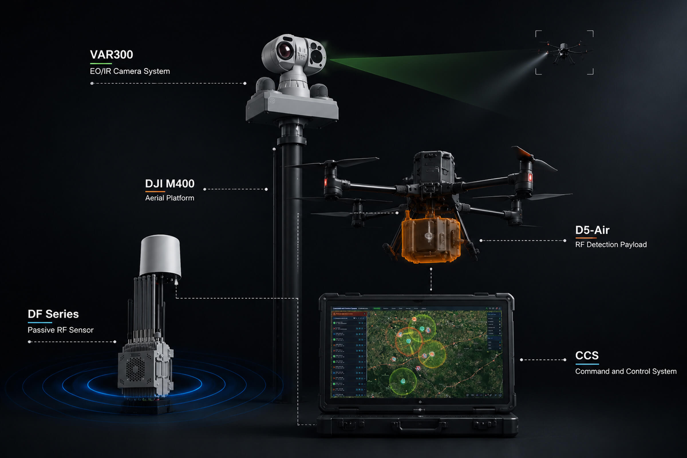
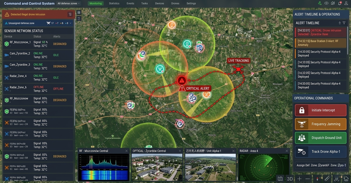
The product portfolio spans portable detection devices like the H3 Pro and HD5, integrated radar and EO/IR platforms like the TR100, and a range of RF detection and jamming modules that system integrators can incorporate into their own solutions. The CCS platform provides the software layer that connects these sensors into a unified operational picture, handling sensor fusion, alert prioritization, and automated response workflows.

As the market accelerates from pilots to procurement, the companies that succeed will be those with production-ready hardware across multiple sensor categories, established global distribution and support networks, and a software platform that integrates sensors from different manufacturers. LZ TECH has invested in all three areas over multiple years and across multiple product generations. The company is positioned to supply both end-user organizations that need complete systems and integrators that need OEM modules to build their own solutions, serving customers ranging from national defense agencies to commercial security providers operating at airports, ports, and energy facilities.

What to Expect Through the End of 2026 and Into 2027

The four signals described above are unlikely to be the last major market developments in 2026. Several trends suggest continued market acceleration.

Regulatory mandates for drone detection at critical infrastructure sites are under active consideration in multiple jurisdictions. The European Union, the United Kingdom, several Middle Eastern states, and parts of Asia are developing or have recently enacted regulations that require certain categories of infrastructure operators to maintain drone detection and response capability. If these mandates continue to expand, they will create a new category of demand from civilian infrastructure operators who have not previously been buyers of counter-drone equipment. This is a large addressable market that has barely been tapped.

The growing availability of counter-drone systems at price points accessible to municipal police departments and private security firms will further expand the addressable market beyond national defense agencies. Motorola’s entry into the market through the D-Fend acquisition is a leading indicator of this trend. When counter-drone capability becomes available through the same sales channels that supply police radios and body cameras, adoption by local law enforcement will accelerate rapidly. A police department that already buys Motorola radios is a natural customer for a Motorola-integrated counter-drone solution.

Standardization of sensor interfaces and command-and-control protocols, driven by frameworks like the NATO C-UAS Marketplace, will reduce integration costs and make it easier for end users to combine sensors from multiple manufacturers. This benefits the entire industry by reducing the friction of deploying multi-sensor systems and by creating a larger market for interoperable components. It also benefits end users by giving them more choice: a standardized interface means they can select the best sensor for each function rather than being locked into a single vendor for all components.

The counter-drone market in 2026 is not what it was in 2023. The evidence from financial markets, manufacturing investment, merger and acquisition activity, and defense procurement frameworks all points in the same direction. The industry is entering its next phase, and the companies that built production capability and global distribution during the earlier pilot phase are the ones positioned to supply the procurement wave that is now arriving.

For end users evaluating counter-drone solutions, the market conditions described here have practical implications. More competition and larger production volumes mean better equipment at lower cost. Standardized procurement frameworks mean faster acquisition timelines. Integration with established public safety platforms means simpler deployment and lower training requirements. The maturation of the counter-drone market is good news for the organizations that need these systems to protect their people, assets, and operations from drone threats that continue to grow in number and sophistication.

The counter-drone industry has spent the better part of a decade building the technology foundation. Now the market infrastructure is catching up: procurement frameworks, integration standards, distribution channels, and the institutional awareness needed to turn technical capability into operational deployment. The next chapter of this industry will be written not in research labs, but in the field.

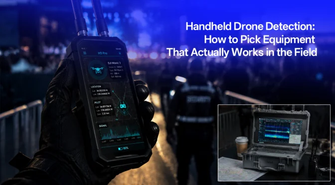
How to Choose Portable Drone Detection Equipment: A Practical Guide to H3 Pro and HD5

When a security team needs to find a drone that just appeared over their facility, they care about two things: where exactly the drone is, and who is flying it. A compass bearing that points toward the general direction of the signal is not enough. In a dense urban environment or a sprawling industrial site, a bearing angle could correspond to any building within a wide arc, spanning hundreds of meters of uncertainty.

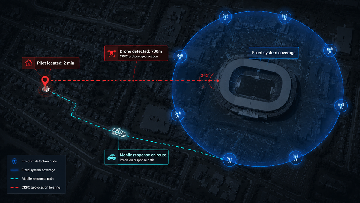
This is where protocol-based drone detection makes a critical difference. LZ TECH’s portable detection devices do not rely on antenna arrays to estimate an angle of arrival. Instead, they receive and decode the drone’s own telemetry transmissions to extract precise GPS coordinates, serial number, model, altitude, and speed. The result is not a rough direction. It is an exact location and a confirmed identity.

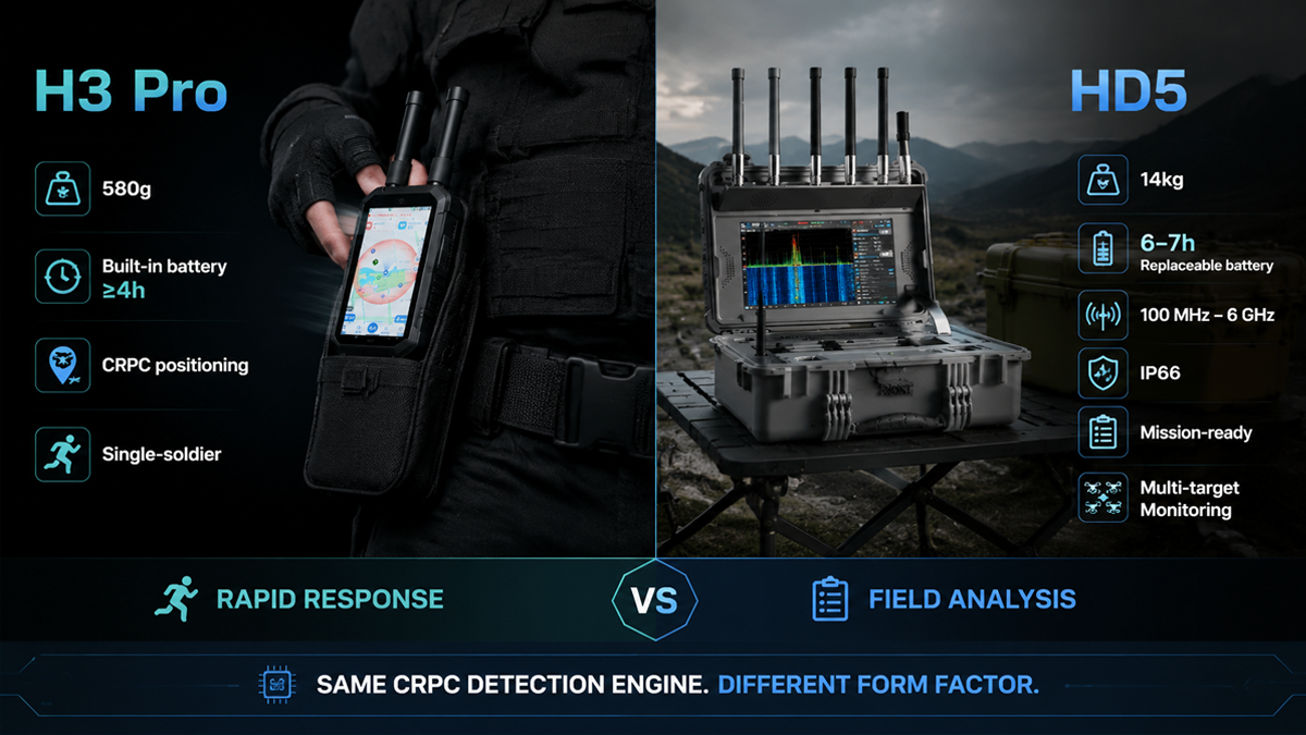
This guide compares two portable detection form factors from LZ TECH: the H3 Pro, a 580-gram single-soldier unit, and the HD5, a 14-kilogram portable system in a rugged case. Both use the same CRPC protocol decoding engine. The choice between them depends on the mission profile, not on detection capability. This article explains the technology, the specifications, and the operational factors that should guide the decision.

The Core Technology: Protocol Parsing Versus Direction Finding

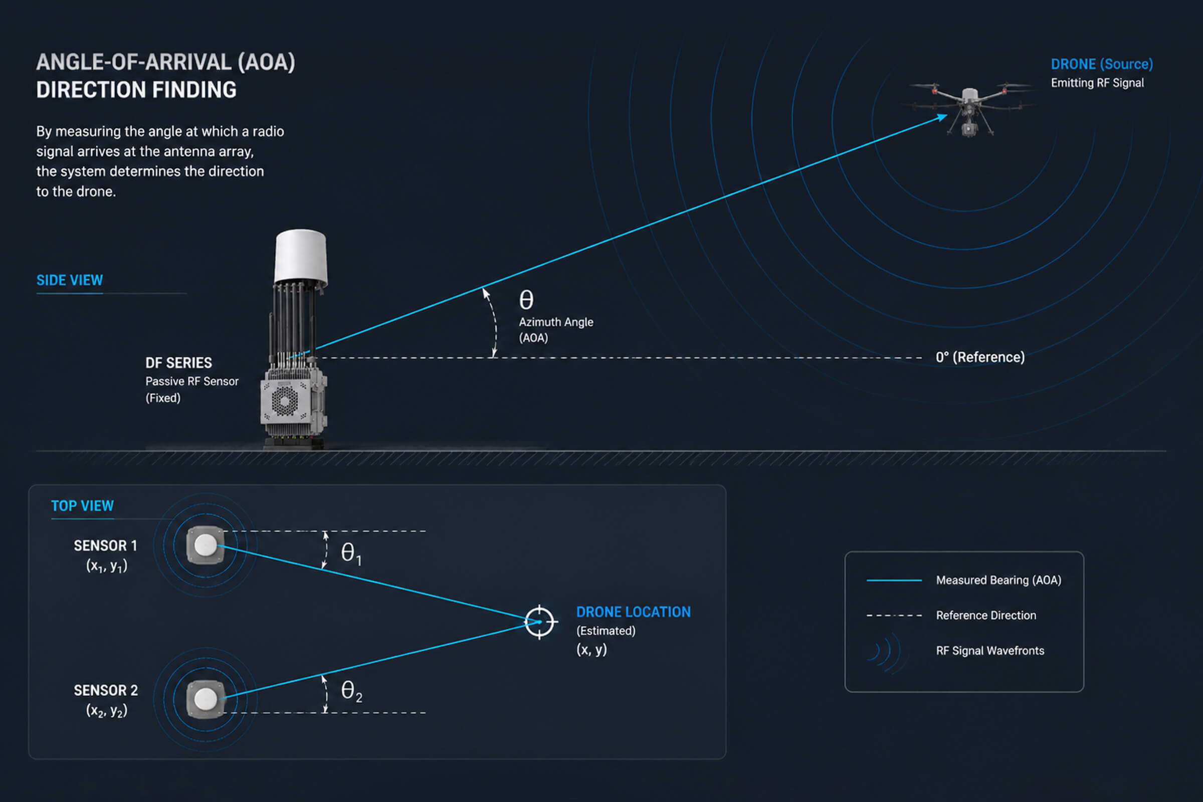
To understand why protocol parsing matters, it helps to understand the alternative. Traditional drone detection systems use antenna arrays to measure the angle from which a radio signal arrives. By comparing the phase difference of a signal received across multiple antennas, the system can estimate a bearing. This technique is called direction finding, and it has been used in electronic warfare for decades.

Direction finding works reasonably well for strong, continuous signals in open terrain. But it has fundamental limitations when applied to drone detection. The bearing accuracy is typically 5 to 15 degrees. At a range of 1 kilometer, a 10-degree bearing error translates to an uncertainty zone roughly 175 meters wide. In an urban environment with buildings that reflect and scatter radio signals, the accuracy can degrade further due to multipath propagation.

Furthermore, a bearing angle tells you approximately where the drone is but nothing about what it is. You do not get the drone model, serial number, or the location of the remote controller. All you know is that a signal of a certain type is coming from a certain general direction. This is useful but incomplete information for a security response.

Protocol parsing works on a completely different principle. Modern drones continuously broadcast telemetry data during flight. This data includes the drone’s GPS position, altitude, speed, heading, battery level, serial number, and model identification. Some protocols also transmit the GPS position of the remote controller, which is the location of the pilot operating the drone.

This telemetry is transmitted through standard communication protocols. CRPC is a common drone communication protocol suite used by several major manufacturers. Remote ID (RID) is a regulatory requirement in many jurisdictions that mandates drones to broadcast identification and location data. DroneID is a proprietary protocol used by DJI for remote identification.

A detection device that can receive and decode these protocols can read the drone’s own navigation data directly from its transmissions. The device does not need to estimate anything from the signal angle. It simply reads what the drone is already broadcasting about itself.

The practical advantage is immediate and significant. Instead of a bearing angle that points somewhere within a large sector, the operator sees a dot on a map showing the drone’s current GPS position and, where available, the remote controller’s position. The device also displays the drone model, serial number, flight altitude, and speed. This is actionable intelligence that enables a directed response.

H3 Pro: The 580-Gram Tactical Single-Soldier Unit

Form Factor and Physical Specifications

The H3 Pro weighs 580 grams or less without the antenna, and approximately 46 grams per antenna module. With dimensions of 177 millimeters by 89 millimeters by 30 millimeters, it is roughly the size of a large smartphone or a small tablet. It fits in a cargo pocket, a small pouch on a plate carrier, or a compact equipment bag.

This is the lightest form factor in LZ TECH’s detection product line. For a dismounted soldier or a patrol officer who is already carrying body armor, a weapon, communications gear, and other equipment, every gram counts. A 580-gram detection device is negligible compared to the burden of carrying a tripod-mounted antenna array or a laptop-sized detection system.

The device features a 6-inch display screen for viewing the tactical map, drone list, and alert information. The screen is large enough to provide clear situational awareness at a glance while keeping the overall device compact enough for handheld or body-worn use.

Battery and Runtime

The H3 Pro uses a built-in lithium battery with a capacity of 12,000 milliampere-hours. Continuous runtime is 4 hours or more under normal operational conditions. The device supports charging while in use, so an operator can connect an external power bank during extended missions without powering down the device. The battery is internal and not designed to be swapped in the field. The charge-while-operating feature addresses the need for missions that exceed 4 hours.

This battery design is appropriate for the H3 Pro’s role as a lightweight personal device. A removable battery would add bulk, weight, and mechanical complexity. For the typical mission profile of a dismounted operator, 4 hours of runtime with the option to extend via external power covers the vast majority of operational scenarios.

Detection Specifications

Frequency coverage includes the 800 MHz and 900 MHz bands, 1.2 GHz, 2.4 GHz, 5.2 GHz and 5.8 GHz, and Wi-Fi bands. These discrete bands cover the most common drone communication frequencies used by commercial and consumer drones worldwide. The frequency selection is optimized for weight and power efficiency: it covers the bands where the vast majority of drones operate, without the power consumption and antenna complexity of full continuous spectrum coverage.

Detection range is up to 3 kilometers, depending on terrain, signal conditions, and the drone’s transmission power. In open terrain with line of sight to the drone, the full 3-kilometer range is achievable. In urban or obstructed environments, the practical range depends on signal propagation through buildings and other obstacles.

The device can simultaneously detect 15 or more drones and maintain trajectory tracking for 11 or more drones. Position accuracy is 3 meters RMS or better, with a response time of 5 seconds or less from signal detection to alert display.

The H3 Pro is a passive detection device. It receives signals only and emits nothing, making it electronically undetectable by the drone operator. There is no transmission that could reveal the operator’s position or trigger countermeasures.

It also supports analog FPV video transmission decoding, allowing the operator to view the drone’s own camera feed when the drone transmits analog video on standard frequencies. This provides an additional layer of situational awareness: the operator can see what the drone’s pilot sees, confirming the drone’s observation target and intent.

Deployment Model

The H3 Pro is designed for single-soldier use: one device per operator, providing personal situational awareness in the field. Each operator sees their own tactical display and can operate independently.

Through LZ TECH’s control platform, multiple H3 Pro units can collaborate as a networked detection grid. Each unit shares its detections with all other units on the network, enabling a team to build a common operating picture that shows every drone detected by any operator, regardless of which individual device received the signal. This networked mode turns a collection of individual devices into a distributed sensor network without requiring a central command post or vehicle-mounted server.

HD5: The 14-Kilogram Portable System in a Case

Form Factor and Physical Specifications

The HD5 is a different category of portable equipment. It weighs 14 kilograms including the battery and is housed in a rugged transport case measuring 470 millimeters by 357 millimeters by 176 millimeters when closed. The case carries an IP66 rating when closed, providing complete protection against dust ingress and powerful water jets from any direction.

This is not a handheld device. It is a portable system that one or two people can carry to a deployment site, set up in a few minutes, and operate from a fixed position or from inside a vehicle. The 14-kilogram weight includes everything needed for operation: the processing unit, the 13.3-inch touchscreen display, the antenna array, and the battery.

The HD5 features a foldable antenna interface for rapid deployment. The operator opens the case, unfolds the antennas, powers on the system, and the device is operational. The 13.3-inch touchscreen provides a large, detailed operator interface suitable for sustained monitoring over a full shift.

The modular design supports extension through additional hardware modules, allowing the system to be configured for specific mission requirements. The IP66 rating means the system can operate in rain, dust, and harsh outdoor conditions when the case is appropriately configured for deployment.

Battery and Power

The HD5 operates from either a built-in lithium battery or AC mains power at 110 to 240 volts. This dual power capability means it can run on battery for mobile or remote deployments, or plug into grid power for fixed-site or vehicle-based operations with unlimited runtime.

Battery runtime is 6 to 7 hours, covering a full operational shift. The battery uses a plug-in replaceable design: the operator can remove the battery pack and replace it with a charged spare unit. This is not a hot-swap mechanism. The system should be powered down before the battery is replaced. A team that maintains a charged spare battery can achieve near-continuous operation by swapping batteries between shifts or during planned downtime.

The 6-to-7-hour runtime is well-matched to the HD5’s role as a vehicle-mounted or fixed-position sensor. Unlike the H3 Pro operator who may be on the move for hours at a time, the HD5 operator is typically stationary, monitoring a screen, and can manage battery changes as a planned procedure rather than an emergency swap.

Detection Specifications

The HD5 covers a continuous frequency range from 100 MHz to 6 GHz, with particular sensitivity in the main drone communication bands: 433 MHz, 900 MHz, 1.4 GHz, 2.4 GHz, 5.2 GHz, and 5.8 GHz. This continuous coverage allows the HD5 to detect drones operating on less common frequencies outside the standard ISM bands, providing broader detection coverage than the H3 Pro’s discrete band approach.

Detection range is up to 5 kilometers for CRPC, RID, and DroneID protocol signals, depending on terrain and signal propagation conditions. The HD5 shares the same CRPC protocol parsing engine as the H3 Pro, providing the same capability to extract GPS coordinates, drone identity, and remote controller position from decoded telemetry data. The detection methodology is identical. The extended range comes from the HD5’s larger antenna array and more sensitive receiver front end.

How to Choose Between H3 Pro and HD5

The decision between these two devices is not about detection quality. Both use the same protocol decoding engine and provide the same fundamental capability: precise drone GPS coordinates and identity. The decision is about the mission profile and operational constraints.

Choose the H3 Pro When:

The operator is on foot and needs to minimize carried weight. A 580-gram device that fits in a pocket is the obvious choice for dismounted patrols, tactical teams moving quickly, or any situation where every gram matters. The 4-hour built-in battery with charge-while-operating support covers typical mission durations, and external power banks are widely available and inexpensive for extended operations. The H3 Pro is the right tool for a single operator who needs personal drone awareness while moving.

Choose the HD5 When:

The deployment is vehicle-mounted or at a fixed checkpoint or observation post. The 14-kilogram weight is irrelevant when the system sits on a vehicle’s passenger seat, on a desk inside a security post, or on a tripod at a fixed observation point. The larger 13.3-inch touchscreen provides a better operator experience for sustained monitoring over hours-long shifts. The 6-to-7-hour battery life covers a full shift without external power, and the plug-in replaceable battery design allows a team to maintain continuous coverage by swapping batteries. The IP66-rated case protects the equipment during transport and when deployed in adverse weather. The wider continuous frequency coverage from 100 MHz to 6 GHz provides detection capability for drones using non-standard frequencies.

What Both Devices Deliver: Coordinates, Not Bearings

Regardless of which form factor is chosen, both the H3 Pro and HD5 provide the same fundamental capability: precise drone location and identity through protocol decoding. An operator using either device does not get a vague compass bearing. They see the drone’s exact GPS coordinates plotted on a map, along with the remote controller’s position, the drone model, its serial number, and its flight altitude and speed.

This is the difference between knowing that a drone is somewhere to the northeast and knowing that a DJI Mavic 4 with serial number X is hovering at 120 meters altitude, 850 meters away at coordinates Y, while its pilot is standing 600 meters away at coordinates Z. The second scenario enables a directed response. The first scenario only enables a search. For a security team with limited personnel and time, the difference between a search and a response can be the difference between intercepting a threat and watching it complete its mission.

The protocol parsing approach also provides legal and operational benefits. Knowing the drone’s serial number and model provides evidence that can support prosecution or incident reporting. Knowing the remote controller’s position enables law enforcement to locate and detain the pilot, which is the only way to permanently neutralize a drone threat. Jamming or kinetic interception stops the drone in the moment. Locating the pilot stops the threat at its source.

Conclusion

Portable drone detection equipment has matured from experimental prototypes to production hardware available in multiple form factors. The technology that matters most is not the antenna design or the enclosure material. It is the ability to read drone telemetry data and provide coordinates rather than bearings. Both the H3 Pro and HD5 deliver this capability, at 580 grams and 14 kilograms respectively, for two different operational profiles.

For a patrol officer who needs to know what is flying overhead right now, the H3 Pro is the answer. It is light enough to carry all day, it provides 4 hours of runtime with the option to charge while operating, and it gives the operator exact drone positions and pilot locations on a map. For a checkpoint team or a vehicle-mounted sensor operator running a full shift, the HD5 provides more screen real estate, longer battery endurance, wider frequency coverage, and weatherproofing that the smaller device cannot match. The detection engine is the same. The choice is about how you carry it and how you use it.

Echodyne’s 30,000-Unit Radar Factory Signals Mass Demand for Counter-Drone Radar – Where TR100 Fits

In mid-2026, radar manufacturer Echodyne opened a new production facility with an annual capacity exceeding 30,000 MESA radar units. It is a significant signal for anyone watching the counter-drone industry: the demand for small-target detection radar is no longer experimental or niche. It is moving into volume manufacturing.

A factory producing 30,000 radar units per year represents a structural shift in how the market thinks about drone detection sensors. For context, a typical defense radar program might order a few hundred units over its lifetime. A few thousand units over several years is considered a large program. Thirty thousand units per year is a completely different category. It means the manufacturer expects demand from multiple procurement programs running simultaneously, across different customer types and geographic regions.

This article examines what the Echodyne factory expansion tells us about the state of counter-drone radar demand, explains the radar fundamentals that matter for drone detection, and describes where the LZ TECH TR100 integrated radar and electro-optical platform fits into a market that is clearly scaling up.

What the Echodyne Factory Expansion Actually Means

Echodyne’s MESA (Metamaterial Electronically Scanned Array) radar is one of the best-known compact phased-array radars on the market. The company has supplied systems to the U.S. Department of Defense, Homeland Security, and allied governments for perimeter security, drone detection, and border surveillance.

The MESA platform is notable for using metamaterials to achieve electronic beam steering in a flat-panel form factor, without the mechanical complexity of a rotating antenna. This makes it suitable for fixed-site installations where reliability and low maintenance are priorities. The technology has been battle-tested in operational environments and has built a strong reputation among defense users.

The jump to 30,000-unit annual capacity signals that Echodyne sees market demand expanding well beyond its current customer base. A factory of this scale is not built on speculation alone. It is typically backed by either confirmed multi-year procurement contracts or a well-founded forecast of demand growth across multiple customer segments. Either way, it represents a vote of confidence in the counter-drone radar market that is hard to ignore.

This aligns with what we are seeing across the counter-UAS sector. Governments are no longer running pilot programs that test a few sensors at a single site. They are writing procurement budgets for nationwide deployment programs. The drone threat has moved from conceptual to operational, and the demand for detection sensors is scaling accordingly.

Three Demand Signals Embedded in One Factory

The 30,000-unit capacity is not just one number. It reflects at least three distinct demand forces that are converging in the counter-drone market.

1. Airspace Awareness Mandates Are Becoming Law

Several countries now require critical infrastructure operators to maintain drone detection capability. Airports, power plants, prisons, and sports venues are being told they must know what is flying within their airspace. Radar is the foundation sensor for this requirement because it provides all-weather, day-and-night detection that optical sensors alone cannot match.

The regulatory trend is only accelerating. In Europe, the European Union Aviation Safety Agency has been developing standards for counter-drone operations at airports. In North America, the FAA has extended its authority over drone operations and is working with security agencies on detection requirements. In Asia and the Middle East, several governments have mandated counter-drone systems at critical national infrastructure sites.

For each site that falls under a mandate, the minimum requirement is typically a radar for primary detection, backed by some form of secondary confirmation sensor such as an electro-optical camera. This creates a direct, regulation-driven demand for radar units that did not exist five years ago.

2. Drone Proliferation Is Outpacing Detection Coverage

Commercial drone sales continue to grow globally. DJI alone ships millions of units annually across consumer, enterprise, and agricultural product lines. New manufacturers in China, the United States, and Europe are entering the market with platforms that range from sub-250-gram consumer drones to heavy-lift industrial aircraft.

The ratio of drones in the sky to installed detection sensors is heavily skewed toward the drones. Most critical infrastructure sites, large public events, and urban areas have zero dedicated drone detection capability. Closing that gap means installing radar at a scale that did not previously exist outside military air defense networks.

This is not a temporary imbalance. Drone production is growing faster than the rate at which detection systems are being deployed. The gap is widening, not narrowing, and that creates sustained demand for detection hardware over the medium to long term.

3. Integration Is the Bottleneck, Not Sensor Availability

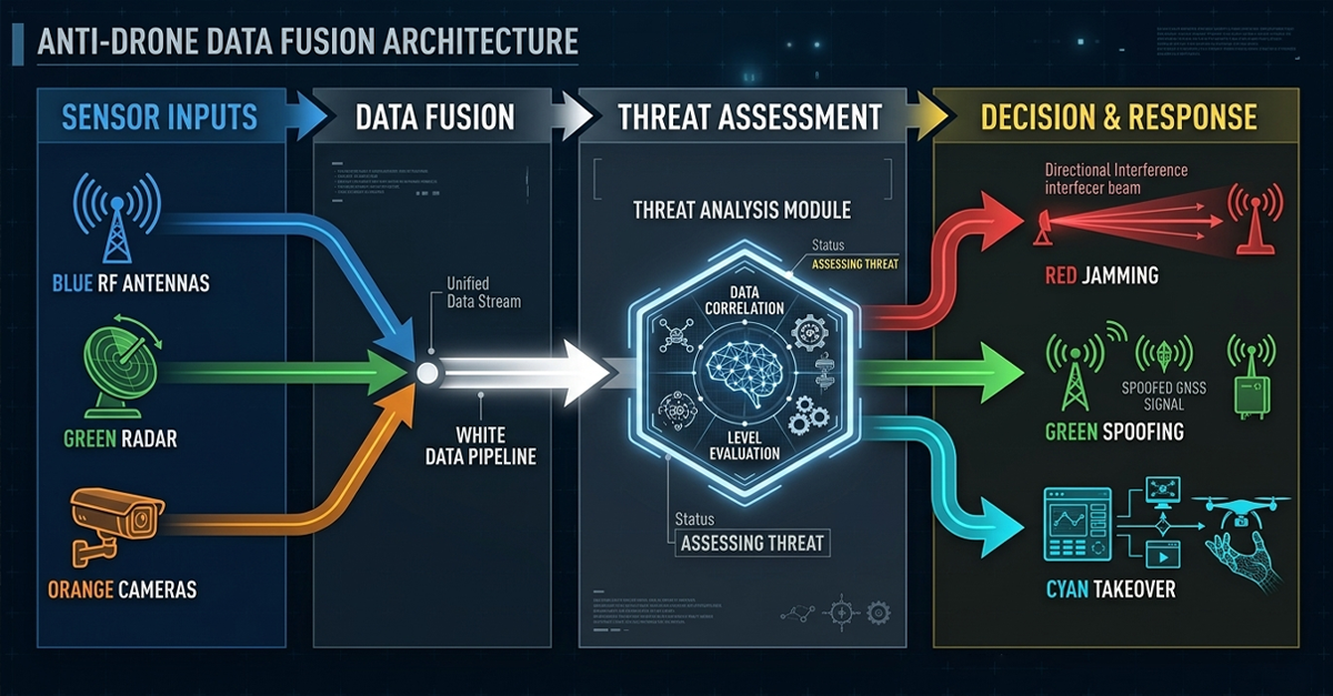
A radar alone does not solve the counter-drone problem. The hardest part is fusing radar data with electro-optical and infrared sensors, RF detection systems, and a command-and-control platform that turns raw tracks into actionable alerts. End users do not want a radar. They want a system that identifies, tracks, and classifies threats with minimal operator workload.

Integration is where the real engineering work happens. A radar produces hundreds of track points per minute. An RF detection system produces signal intercepts. An EO/IR camera produces video. Fusing these data streams into a single coherent picture, with automated classification and alert prioritization, is a software and systems-engineering challenge that many organizations underestimate.

The manufacturers that succeed in this market will be those that solve the integration problem, not those that build the best individual sensor. This is the design philosophy behind the TR100: an integrated unit that combines radar, visible-light, infrared thermal, and wide-angle cameras in a single platform with a shared coordinate frame.

Understanding Radar Cross Section for Drone Detection

Any discussion of counter-drone radar eventually comes back to RCS, or Radar Cross Section. RCS is a measure of how detectable an object is by radar, expressed in square meters. It varies dramatically by the target’s size, shape, material composition, and orientation relative to the radar beam.

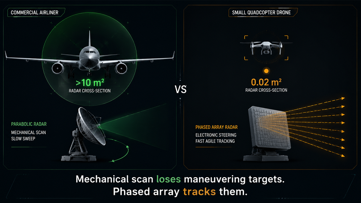
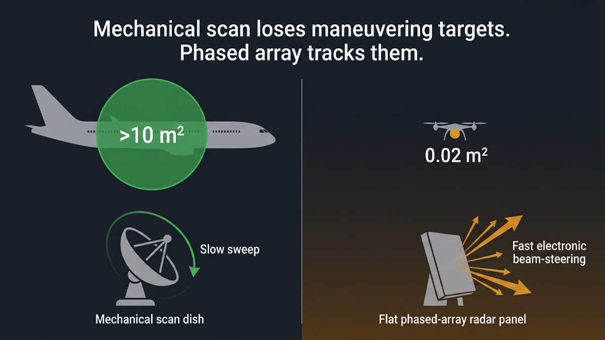
A commercial airliner has an RCS in the range of tens to hundreds of square meters. A fighter aircraft might be in the single-digit range if designed with some radar signature reduction. A small consumer drone like the DJI Mavic series has an RCS around 0.02 square meters. That is roughly the radar return of a small bird.

This is why drone detection radar is a specialized engineering problem. The radar must have enough sensitivity to pick up a tiny, slow-moving object while rejecting clutter from birds, ground vehicles, weather phenomena, and other environmental noise. The signal-to-noise ratio for a 0.02 square meter target at 2 kilometers is extremely challenging.

RCS also varies with the radar frequency and the aspect angle of the target. A drone viewed from the front presents a different RCS than the same drone viewed from the side or from below. The plastic body of most consumer drones is relatively transparent to radar, but the metallic components such as motors, battery, and electronic boards produce returns. The rotating propeller blades create a characteristic micro-Doppler signature that can help distinguish drones from birds.

The TR100 from LZ TECH specifies detection at an RCS of 0.02 square meters for a DJI Mavic 4-class target. This is a realistic and meaningful threshold. It covers the most common commercial drone platforms that security operators encounter in the field. It does not over-promise by claiming detection at 0.001 square meters, which would require military-grade radar at a very different cost point.

The TR100: Integrated Radar and EO/IR in a Single Platform

The LZ TECH TR100 is designed for the integration challenge described above. It combines a phased-array radar with a multi-spectral optical payload in a single unit, reducing the number of separate hardware boxes that an integrator or end user must manage.

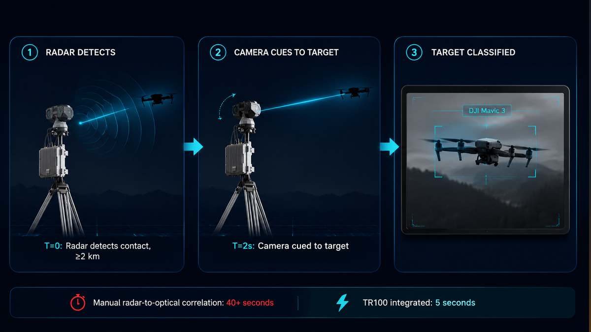
The radar subsystem provides azimuth coverage of at least 90 degrees and elevation coverage of at least 90 degrees. Detection range is at least 2 kilometers against a DJI Mavic 4 class target at 0.02 square meters RCS. Position accuracy is 2 meters or better.

The optical subsystem carries a 6.1 millimeter to 561 millimeter continuous optical zoom lens that covers everything from wide-angle situational awareness to long-range identification. Three camera types operate simultaneously: a visible-light camera, an infrared thermal camera, and a wide-angle camera.

For identification, the TR100 can visually confirm a DJI Mavic 3-class target at 2 kilometers or more during daytime and at 1 kilometer or more at night. For tracking, it maintains a visual lock at 3 kilometers or more during daytime and 2 kilometers or more at night.

The integrated design provides a practical advantage that separate sensors cannot match: the radar and cameras share a common coordinate frame. When the radar detects a target, the cameras slew automatically to the correct bearing without any manual alignment or calibration step. The operator sees a visual confirmation immediately. This tight coupling between detection and identification is what makes a system usable by a security team under operational pressure.

Why Phased-Array Radar Matters for Counter-UAS

Phased-array radar differs from traditional mechanically scanned radar in one critical way: it has no moving parts. The beam is steered electronically by controlling the phase of the signal across an array of antenna elements. This provides several advantages for drone detection that are worth understanding.

First, update rate. A phased-array radar can redirect its beam to any point in its field of view in milliseconds. A mechanical radar must physically rotate its antenna, giving it a refresh cycle measured in seconds. For a fast-moving drone that can change direction instantly, a high update rate is essential for maintaining a stable track. If the radar only looks at the target once every few seconds, the track can break or jump between updates.

Second, reliability. No motor, no gears, no bearings to wear out. For permanently installed systems that must operate 24 hours a day, 365 days a year, in outdoor conditions, this reduces maintenance burden significantly. A mechanical radar deployed at a remote site requires periodic servicing. A solid-state phased-array radar can, in principle, operate for years without physical maintenance.

Third, multi-target handling. A phased-array radar can interleave tracking and search functions, simultaneously following multiple targets while continuing to scan for new ones. This is the operational mode in which Echodyne’s MESA radar and the TR100’s radar both operate. It is particularly important for counter-drone missions where multiple drones may be approaching from different directions simultaneously.

Fourth, resistance to jamming. Phased-array radars can adapt their beam pattern electronically to suppress interference from specific directions. This provides a degree of electronic protection that mechanical radars cannot easily replicate.

a

Where TR100 Fits in the Growing Radar Market

The counter-drone radar market is segmenting into roughly three tiers. At the high end are military-grade 3D radars with ranges exceeding 10 kilometers, full hemispherical coverage, and price tags in the hundreds of thousands to millions of dollars. These systems are designed for integrated air defense networks and are typically too expensive for civilian infrastructure applications.

At the low end are simplified Doppler sensors that can detect movement but cannot track, classify, or provide precise coordinates. These are useful for triggering alerts but provide limited situational awareness on their own.

The TR100 occupies the middle tier: a professional-grade phased-array radar with integrated EO/IR, designed for the 2-kilometer detection class that covers most real-world operational scenarios at airports, borders, critical infrastructure sites, and event venues. It provides the core capabilities that security teams need, without the cost and complexity of a military air defense radar.

This middle tier is where the volume demand is materializing. Most sites do not need to detect drones at 10 kilometers. They need reliable detection within a 2-kilometer perimeter, with automated visual confirmation and tracking. As factories like Echodyne’s scale up to 30,000 units per year, they are betting that this middle tier will generate procurement volumes that were previously reserved for consumer electronics, not defense sensors.

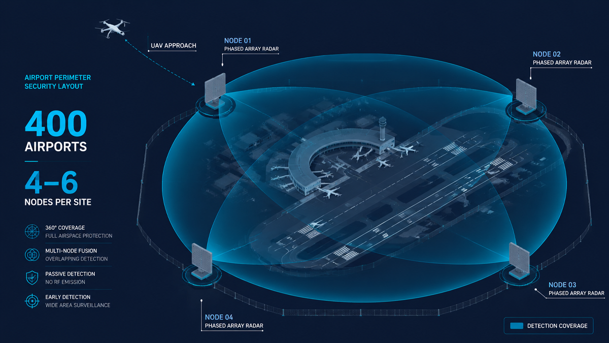
The TR100 is designed to operate as a standalone detection and identification unit, or to integrate with broader RF detection and jamming systems through LZ TECH’s CCS command-and-control platform. The platform handles sensor fusion, alert prioritization, and automated response workflows so that a security operator can manage multiple sensors without being overwhelmed by raw data streams. Multiple TR100 units can be networked to extend coverage across a site, sharing tracks and maintaining consistent target identification across sensor boundaries.

Conclusion

Echodyne’s factory expansion is one data point among many, but it is a telling one. When a radar manufacturer commits to 30,000-unit annual capacity, they are betting that the counter-drone market is entering a procurement phase, not a trial phase. The TR100 addresses the same market demand from the system-integration side: providing a radar-plus-optics unit that is ready to deploy, not just a sensor that needs a separate integration project.

The next several years will determine which architectures become standard for counter-drone detection. The trend is clear: integrated, phased-array, and designed for volume deployment at civilian and paramilitary price points. The TR100 is built for that market reality.

For security planners evaluating counter-drone radar options, the key question is no longer whether radar is needed. That question has been answered by the market signals described in this article. The question is which architecture to adopt. An integrated approach that combines radar, optical sensors, and software into a single deployable unit reduces integration time, operator training burden, and lifecycle maintenance cost. These factors matter as much as raw detection range when a system must operate 24 hours a day, 365 days a year, at sites that may not have dedicated technical staff on hand.

Why Belgium’s Drone Violation Wave Rewrites the Rulebook for Event Airspace Security

The Belgian Directorate General of Aviation, DGLV, published a warning ahead of the summer 2026 event season that reads like a checklist of what European counter-drone regulation is about to become. In 2025 alone, Belgian authorities investigated dozens of drone violations. Not isolated hobbyist incidents. Patterned, high-risk offenses concentrated around the country’s highest-profile events.

Rock Werchter. Tomorrowland. The Spa Formula 1 Grand Prix. Each of those venues saw unauthorized drone flights inside active temporary no-fly zones. Two categories stood out in the DGLV report: unlicensed drone light shows operating outside the Specific category permit framework, and individual drones climbing to altitudes of 500 meters, roughly four times the 120-meter ceiling of the Open category. In both cases, the drones were in the airspace before security teams had a verified picture of what they were dealing with.

The Belgian report is not an outlier. It is the data point that confirms a regulatory shift already underway across Europe. France, Germany, the Netherlands, and now Belgium are moving from post-incident fines to preemptive airspace enforcement. Drone light shows without Specific category authorization have been reclassified from a paperwork error to an operational violation. Temporary no-fly zones around major events are now treated as monitored airspace, not advisory airspace. And for the security integrators and venue operators who build the detection stacks that enforce these zones, the hardware implication is unambiguous: detection is not enough. Verification under pressure is the new minimum.

The difference between detecting a drone and knowing what you are looking at

Most counter-drone deployments start with RF or radar for the detection layer. Those technologies answer one question: something is up there. RF detection picks up a signal on a drone frequency. Radar returns a radar cross-section at a range and bearing. Neither one tells you whether that signal belongs to a rogue DJI Mavic or a licensed event drone that drifted 20 meters past its approved flight boundary.

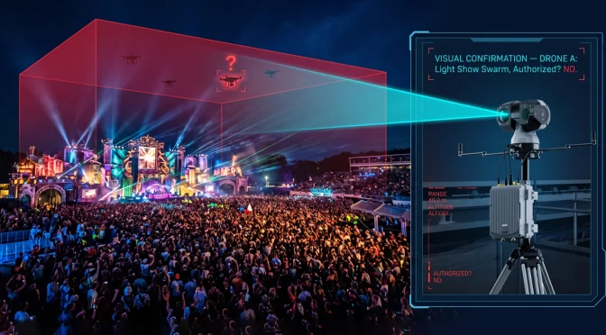
This is exactly the gap that the Belgian violations expose. A drone light show involves a fleet of synchronized aircraft. To an RF detector, a 100-drone light show and a single hostile quadcopter look identical: signals on the same frequency band, from roughly the same azimuth. To a radar, the fleet returns a clustered track that could be anything. The only way to distinguish a coordinated performance from a coordinated incursion is to put eyes on the target. Optical eyes. And that means an EO/IR system that can be guided onto the target fast enough to matter.

The second Belgian scenario, a single drone at 500 meters, pushes the same problem in a different direction. At that altitude, a consumer quadcopter is a speck against the sky or cloud. A security operator with binoculars will not find it before it leaves the airspace. A fixed camera with a wide lens will capture a pixel at best. Visual verification at 500 meters demands optical zoom, thermal sensitivity, and enough edge computing power to lock onto a target before the operator has to make a decision with partial information.

Enter the T100: visual verification built for the moment that matters

The T100 is our team’s three-in-one electro-optical tracking and pointing system. It integrates a visible-light camera, an infrared thermal camera, and a wide-angle camera into a single IP66-rated unit that operates from minus 30 to plus 65 degrees Celsius, around the clock, with 200 TOPS of local edge computing power running multiple deep learning models on-device.

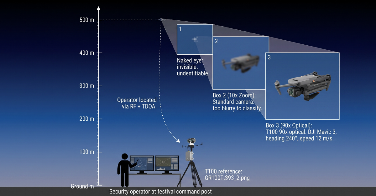
The hardware spec tells one story. The 90x optical zoom with 4K resolution means a DJI Mavic 3 is identifiable at over two kilometers in daylight. The thermal channel, a 640-by-512 vanadium oxide uncooled detector with a 15 mm to 100 mm focal range, pushes identification to one kilometer at night. Medium-sized UAVs push those ranges to four kilometers in daylight and three kilometers after dark. A drone at 500 meters, which is the altitude the Belgian authority flagged as a fourfold Open category breach, is well inside the T100’s identification envelope in both visible and thermal.

But the spec is only half the story. The other half is how the T100 gets onto the target, and what it does once it is locked on. That is where the gaps the Belgian report identified meet the specific engineering decisions our team made when we built the T100’s guidance and tracking pipeline.

Scenario one: the unlicensed drone light show

A 100-drone light show at a major festival looks impressive from the ground. From a detection standpoint, it looks like a problem with a hundred moving parts. The DGLV report highlighted that organizers were running these shows under the Open category, which allows individual drone operation but explicitly excludes coordinated multi-drone flights. The Specific category, which does permit such operations, requires authorization, risk assessment, and an operational safety case. Running a light show without that authorization is no longer a paperwork oversight. It is a violation, and Europe is treating it as one.

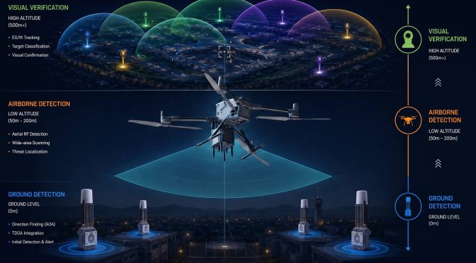
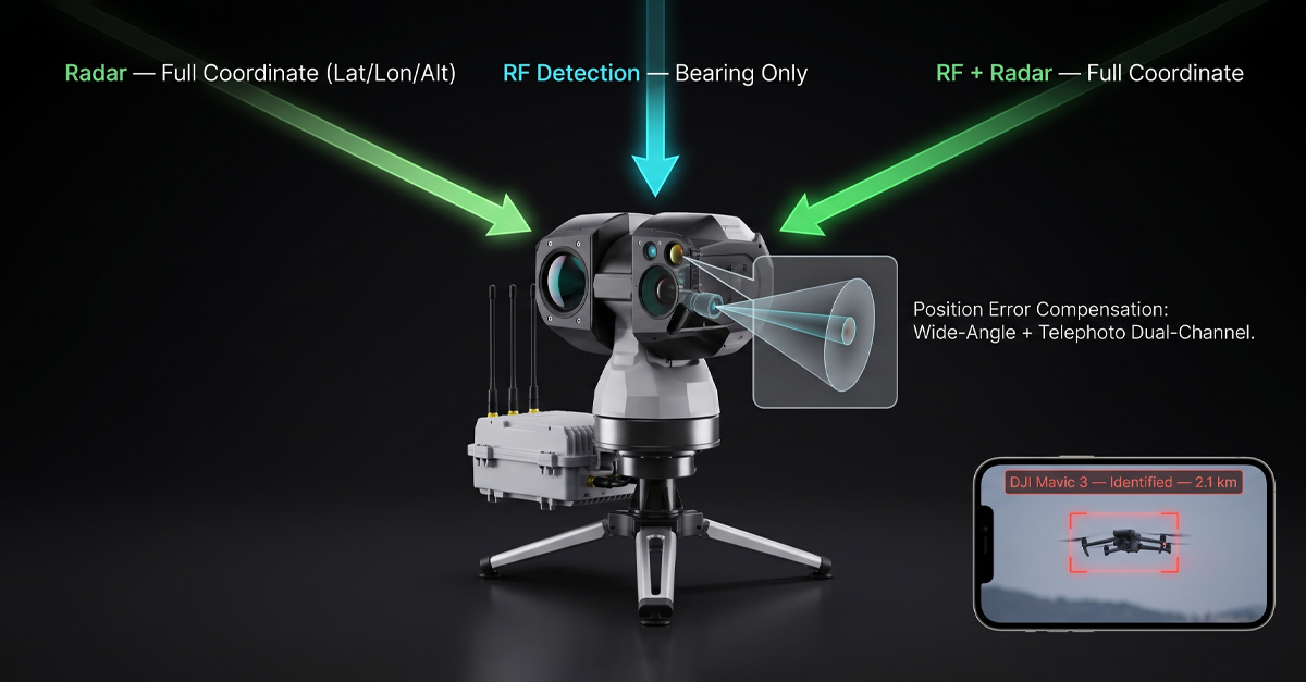
For the venue security team, the operational question is: how do you distinguish an unauthorized light show from a single hostile drone that happens to be flying near clusters of authorized activity? The answer sits in the T100’s multi-source fusion guidance. The system accepts pointing commands from radar systems that provide latitude, longitude, and altitude, and from RF detection systems that provide bearing information. When the detection layer flags multiple contacts in a tight cluster, the T100 slews to the area, activates its wide-angle camera for area search, and then shifts to the telephoto channel the moment a drone enters the field of view.

The 200 TOPS edge computing unit runs classification models on-device. It distinguishes drones from birds, kites, and other airborne objects without sending frames to a cloud server and waiting for a response. This matters at a festival where cellular networks are saturated by 80,000 attendees. Cloud-based AI would choke on the latency. The T100’s models run locally, which means the classification arrives while the target is still in frame.

If the visual feed confirms a coordinated formation with uniform spacing, uniform altitude, and the flight pattern of a preprogrammed light show, the operator sees it, logs it, and escalates through the event’s communication protocol rather than triggering an alarm. If the visual feed shows a single drone breaking formation, changing altitude erratically, or heading toward the crowd, the operator has an entirely different decision to make. The T100 does not make that decision. It makes sure the operator is not making it blind.

Scenario two: the 500-meter drone

A drone at 500 meters is invisible to the naked eye. It is barely visible to a standard security camera with a fixed wide-angle lens. At that altitude, the acoustic signature is gone. The drone is a silent speck. If the operator has a zoom camera, but it takes 20 seconds to acquire the target, the drone has moved 300 meters at a modest 15 meters per second. The window for visual verification closes before the camera even finishes focusing.

The T100 closes that window with two design choices. First is the active search pattern. When guidance data from radar or RF arrives, the T100 does not simply point at the reported azimuth and wait. It executes a predefined scan pattern, either grid or 3-by-3, with real-time AI detection running on every frame. The wide-angle channel covers a broader sector. The telephoto channel zooms on the first detected target. The moment the AI pipeline detects a drone in any frame of the scan, the system switches from search mode to tracking mode automatically. The operator does not manually slew, zoom, or hunt. The system acquires.

Second is the position error compensation. Guidance data from an RF system carries inherent uncertainty. Signal reflection off buildings, multipath from terrain, and the drone’s own movement during the pointing cycle all contribute to a bearing error that can push the target outside a narrow telephoto field of view. The T100’s wide-angle plus telephoto dual-channel architecture absorbs that error. The wide-angle channel captures the sector that contains the target. The telephoto channel zooms in on the specific contact within that sector. In our own testing, this architecture supports higher position deviations than conventional single-channel EO systems can tolerate. For an operator tracking a 500-meter drone that a bearing-only RF system can only locate to within a few degrees, the error compensation is the difference between acquiring the target and watching it disappear into the cloud.

Why deployment speed matters for temporary no-fly zones

The Belgian violations did not happen at permanent installations. They happened at temporary event no-fly zones. Rock Werchter runs for four days. The Spa Grand Prix runs for three. Each venue has a no-fly zone that exists for less than a week, and the detection equipment arrives, gets set up, and needs to be operational before the first gate opens.

In the conventional EO market, deployment is slow. The unit needs manual compass calibration. The focus needs adjustment to compensate for the temperature difference between storage and the summer field conditions. Integration with the radar or RF system that brought the unit to the event requires a technician to configure communication protocols, coordinate axes, and test handoff sequences. A two-hour setup window before the first crowd arrives is easily consumed by integration debugging between equipment from different manufacturers.

The T100 was designed to invert that timeline. Auto-compass calibration means the unit orients itself after a single initial calibration. No drone flyover. No auxiliary reference hardware. The unit powers on, orients, and is ready to accept guidance data. Integration with radar and RF systems is plug-and-play. Our team built the T100 to work natively with our own counter-drone products, including the D5-Air, D5-B, DF5 MAX, and H3 Pro detection systems. And it integrates directly with third-party radar and RF equipment through standard guidance protocols. The result, measured in our own field deployments, is a setup time of approximately ten minutes from unboxing to operational readiness.

The blind spot nobody talks about: what happens when jamming starts

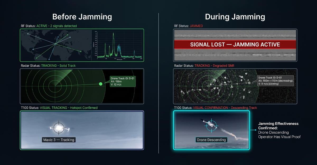
There is an operational reality in counter-drone deployments that most product brochures skip. When jamming activates, RF detection goes silent. The jammer is transmitting across the very bands the detector is listening to. No detection signal. No updated guidance data. And yet, at that exact moment, the security team needs to know one thing more than any other: is the jamming working?

The T100 answers that question optically. When the RF detection layer drops offline because jamming is active, the T100 keeps watching. The thermal channel tracks the drone’s heat signature. The visible channel confirms its visual profile. The tracking algorithm maintains a lock, and the operator sees the target’s behavior in real time. If the drone descends, changes heading, or begins an uncontrolled fall, the operator confirms the jamming is effective. If the drone continues on course, the operator knows the frequency coverage needs adjustment. Either way, the operator has an answer. Without an EO/IR system in the stack, the operator has a blank screen and radio silence that could mean anything.

This is not a theoretical scenario. The DGLV report did not mention jamming because the regulator’s role is to document violations, not to prescribe the neutralization response. But for integrators who design the full detect-to-neutralize chain, the handoff gap between RF and jamming is a known vulnerability. The T100 closes it.

Edge AI: why the model has to run on the device, not in the cloud

The T100 packs 200 TOPS of local computing power. That number matters for three reasons that stack in the event-security context.

First, latency. A camera frame arrives at the processing unit. The AI model detects an object, classifies it, and returns a label before the next frame arrives. This happens at the frame rate of the camera, on the device. No round-trip to a cloud inference server. No 4G congestion at a festival. No intermittent connectivity at a rural venue. The classification pipeline runs regardless of what the cellular network is doing.

Second, model specificity. The T100’s deep learning pipeline distinguishes drones, birds, kites, and other airborne objects. In a field test at 500 meters, a bird circling a thermal and a drone hovering can look nearly identical to a basic motion-detection algorithm. The T100’s models are trained on the features that separate them: motion pattern, aspect ratio over time, thermal signature profile, and wing-flap frequency versus rotor-blade frequency. The edge unit runs multiple models simultaneously. If a specific deployment site introduces a new false-alarm source, our team can retrain the models on site-specific data and update the unit.

Third, what the model output enables is that once the AI pipeline classifies a contact as a drone, the T100’s tracking algorithm locks on. It combines correlation filtering, deep feature tracking, and edge tracking into a fused lock that holds through partial occlusion, background clutter, and rapid changes in the target’s aspect angle. The operator sees a stable track with a bounding box and a classification label, not a jittering crosshair that wanders off target whenever the drone banks.

The regulatory direction: Europe is raising the bar on event airspace

The Belgian DGLV warning is the latest signal in what is now a clear trajectory across Europe. France has been running its own event-season enforcement campaigns, with dedicated drone detection units deployed at major festivals and sporting events. Germany passed updated airspace legislation that gives local authorities the power to impose and enforce temporary no-fly zones with real-time monitoring requirements. The Netherlands is piloting a centralized drone traffic management platform that connects venue-level detection data to a national airspace picture.

Each of these developments adds a requirement to the event security integrator’s checklist. Detection coverage is not enough. The detection layer needs to produce verified identification that can be logged, timestamped, and submitted as evidence if a violation leads to prosecution. A radar track labeled ‘unknown contact’ does not meet that standard. A visual confirmation with a 4K image of the drone, its heading, and its altitude does. The T100, by design, captures and timestamps every detection and track event. The data is exportable for incident reporting, and it is structured to feed into the kind of centralized airspace monitoring platforms that the Netherlands and others are piloting.

Integration: EO/IR that works with what you already have

One of the persistent friction points in counter-drone deployment, and one our team identified in our own market research before we designed the T100, is that EO/IR systems, radar systems, and RF detection systems typically come from different manufacturers. The integrator spends hours, sometimes days, making them talk to each other. Guidance handoffs fail. Coordinate systems do not align. The radar reports a target at 47 degrees, the EO unit interprets that as 49 degrees, and the drone flies through the two-degree gap while the systems argue about calibration.

The T100 was engineered to reduce that friction as close to zero as possible. With LZ TECH’s own products, the integration is native. Connect a D5-Air, D5-B, DF5 MAX, or H3 Pro to the T100, and the guidance handoff works out of the box. With third-party radar and RF equipment, the T100 supports both bearing-only guidance and full-coordinate guidance modes. The unit accepts standard protocol interfaces. Once connected, the commissioning test confirms guidance accuracy, and the system is operational.

For venues that already own RF or radar systems, the T100 adds visual verification without replacing existing investments. Our team has deployed T100 units alongside previously purchased third-party radar at correctional facilities and government sites. The integration is fast because the guidance interface is simple: give the T100 a bearing or a coordinate, and it points, searches, and acquires.

The takeaway from the Belgian summer

The DGLV report is short. Dozens of violations. Dozens of events. Two clear violation categories. A regulator publicly signaling that the Open category is not a loophole for coordinated drone operations and that temporary no-fly zones will be enforced, not advised.

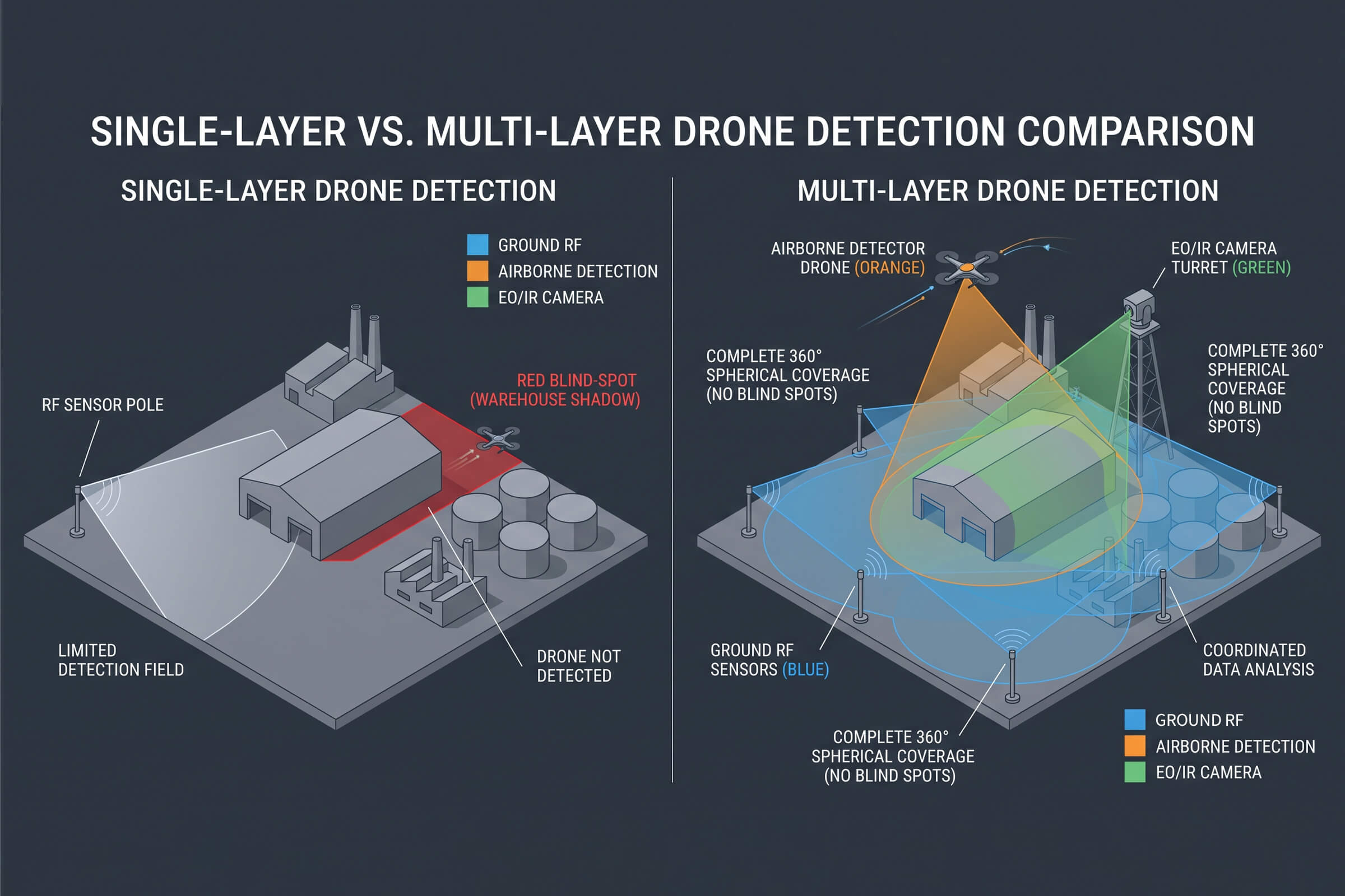
For the integrators and venue operators who build the detection stacks, the report confirms something that has been building for two years: detection alone does not close an airspace. RF tells you a drone is transmitting. Radar tells you something is at a range and bearing. Neither one answers the question that the security controller needs answered: what is it, where is it going, and do I need to act.

An EO/IR system like the T100 answers those questions. It verifies. It classifies. It tracks. It keeps watching when the RF layer goes dark. It deploys in ten minutes on a temporary event site. It feeds verified data into the incident log that a regulator will ask for. And it does all of this with the sensor fusion architecture that separates a counter-drone system from a collection of hardware on separate tripods.

As the European event season heats up and regulators move from warnings to enforcement, the gap between what RF and radar can tell you and what an optical system can confirm is no longer a technical nuance. It is the gap between compliance and a violation report with your venue’s name at the top.


ICAO’s Drone Wake-Up Call: Why Airports Are Turning to TDOA Passive Detection

Something shifted in the counter-drone conversation last week. It was not a Gatwick-style closure or a near-miss over Heathrow that made the difference. It was a two-day workshop in Krakow, Poland, convened by ICAO and hosted by the Polish Civil Aviation Authority. The Secretary General of the International Civil Aviation Organization, Juan Carlos Salazar, said out loud what airport operators and aviation regulators have been saying to each other in private for years: the drone threat is accelerating, fragmenting, and the only credible response is a coordinated one.

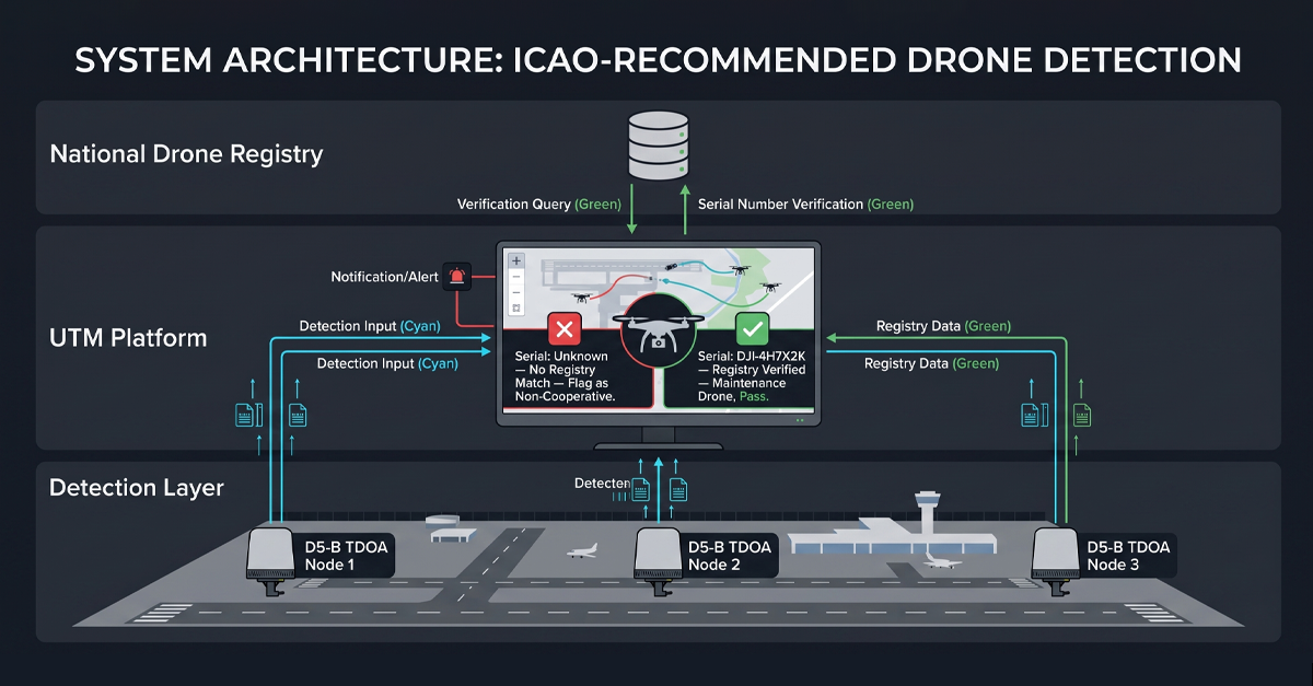
Salazar was not vague about what coordination needs to look like. He called for multi-layered detection equipment working alongside updated aviation regulations. The workshop produced two specific recommendations. First, make UTM platforms interoperable with national drone registries so that cooperative and non-cooperative drones can be told apart in real time. Second, feed civil data, local drone trends, and incident reports into national threat intelligence systems so that risk assessment runs on live data rather than quarterly reports. Within months, ICAO will release a new risk management guide that sets the framework for how every member state should approach drone threats to civil aviation.

For anyone who supplies detection hardware to airports, the Krakow workshop was not an academic exercise. It was a preview of what airport procurement specifications will look like two years from now. Passive. Networked. Interoperable with UTM. Able to tell the difference between a lost delivery drone and a threat. Those requirements describe a detection architecture built around TDOA and protocol-level identification. Not around older approaches that emit, interfere, or stop at frequency detection.

The Krakow workshop: what ICAO actually said

To understand why Krakow matters, look past the diplomatic phrasing. ICAO has historically been slow to act on drones. Member states run their own rules. Drone registration is patchy even in developed markets. Remote ID standards are years behind the actual rate of drone proliferation. For the Secretary General to personally open a counter-drone workshop and call for ‘sustained and determined international attention’ tells you the organization sees a gap between how fast the threat is evolving and how slowly the regulatory machinery has been turning.

The recommendations from Krakow are specific enough to act on. UTM systems, the unmanned traffic management platforms that handle drone airspace, need to talk to national drone registration databases. If a drone broadcasts a registration ID that checks out, it is cooperative. If it does not, or if the ID is spoofed, or if there is no ID at all, the detection system at the airport perimeter needs to flag it immediately. This is not a future wish-list item. It is an operational requirement that ICAO wants member states to implement.

The workshop also pushed for civil drone data to feed into national security intelligence pipelines. Local trend reports. Incident logs. Airspace violation records. If the local police have a record of thirty drone sightings near the approach path in the last quarter, the airport security team should not find that out from a news article. The data exists. The recommendation: connect it.

A new ICAO risk management guide is expected to arrive within months. It will frame how every member state evaluates and mitigates drone threats to civil aviation. For hardware procurement, the guide functions as a reference standard. Airports will benchmark their detection systems against ICAO’s framework. If your detection approach cannot meet the layered, interoperable, passive model that ICAO describes, you will have a procurement problem.

Why airports are the hardest detection problem in C-UAS

Every counter-drone deployment has constraints. Prisons have tall walls and a known threat axis. Border sites have open terrain and predictable approach vectors. Stadiums have defined event windows and manageable perimeters. Airports combine the worst of every other site type into one airspace, and they add requirements no other site has to handle.

The electromagnetic environment at an airport is the most hostile RF space a sensor can operate in. Air traffic control radar. Instrument landing system beacons. VHF communications. Secondary surveillance radar. Weather radar. Ground movement radar. Wi-Fi networks, cellular towers, satellite uplinks. A detection system that emits adds to that noise floor. An active radar for drone detection is not a sensor; it is another transmitter that the frequency manager has to account for, license, and coordinate. Passive detection at an airport is not a preference. It is a constraint the site itself imposes.

Then there is the cost of a false positive. If a detection system triggers a false alarm at a border post, the guards step outside and look. If it triggers one at Heathrow, the tower gets involved, flights get held, airlines file delay claims, and the operator who caused it spends the next week answering questions. An airport detection system does not get to be ‘mostly right.’ It has to know what it saw, what the target is, and where it came from, every single time.

And there is the operator problem. When Gatwick shut down in December 2018 for thirty-six hours over drone sightings, the question that paralyzed the response was not ‘is there a drone?’ It was ‘where is the person flying it.’ RF detection that tells you a drone is somewhere in a two-kilometer arc does not answer that question. To find the operator, you need positioning. Directional data from a single sensor is not positioning. Angle of arrival from a single point degrades with distance. To locate an operator to within ten meters at the far end of the perimeter, you need more than one receiver. You need a network.

TDOA, as a concept, is known in the counter-drone industry, but the implementation varies enormously between suppliers. One name that comes up in the same sentence as TDOA is Terjin, and for good reason — they invested early in the technique and built their positioning around it. But TDOA is not a single-company technology. It is a physical measurement method, the same way phased-array radar is not owned by any one manufacturer. The difference between one TDOA system and another is the signal processing pipeline, the protocol identification layer, and the networking architecture that turns individual receivers into a single detection volume.

Our team at LZ TECH approaches TDOA as one layer in a larger detection stack, not as the entire stack. The D5-B node, which this article examines in detail, pairs TDOA-based positioning with our CRPC protocol-cracking engine so that the system does two things at once: locate the signal source and decode what it is carrying. That combination — positioning plus identity — is what sets the approach apart from TDOA implementations that stop at angle of arrival.

TDOA: the physics that makes airport detection work without the airport noticing

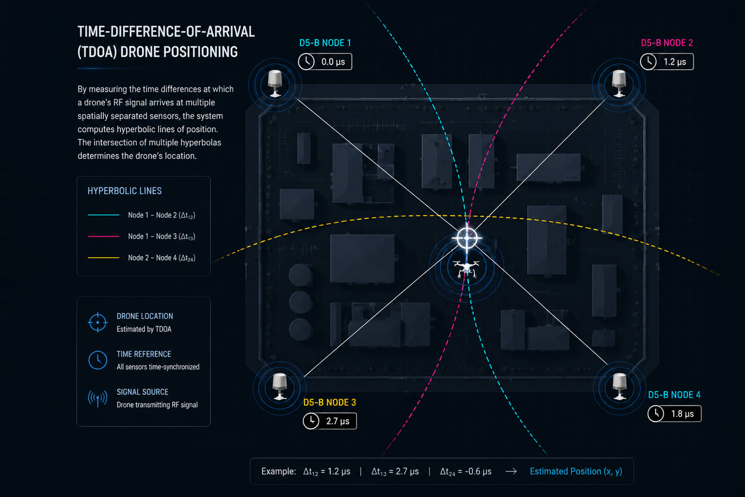
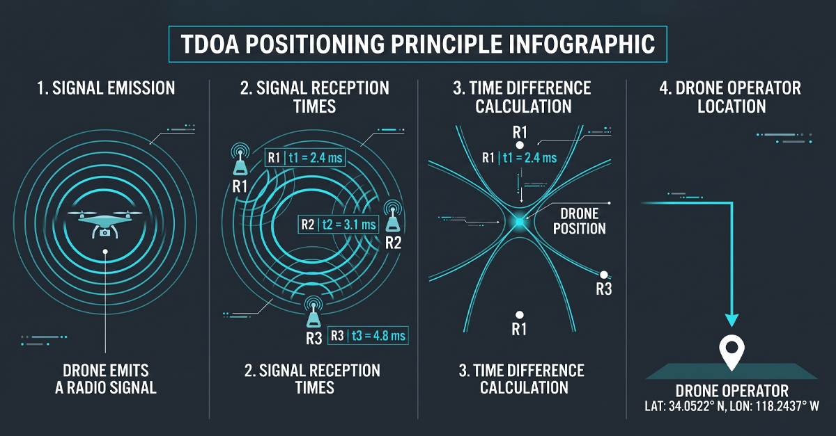
Time Difference of Arrival solves the airport detection problem by reframing it. Instead of asking ‘what does the signal look like,’ TDOA asks ‘when did the signal arrive.’ The principle is simple to describe and hard to do well. Multiple passive receivers are placed at known locations around the protected area. Each receiver time-stamps every drone signal it picks up. Because the receivers are at different physical locations, the same signal arrives at each one at a slightly different time. The time differences, cross-referenced with the known positions of the receivers, give you a position fix on the transmitter. Both the drone in the air and the controller on the ground.

The word ‘passive’ does a lot of work here. TDOA receivers do not transmit. No radar pulse. No interrogation signal. No frequency sweep. The receivers are listening only. That means a TDOA network can be deployed anywhere at an airport without a frequency coordination meeting, without an emissions license, and without adding a single decibel to the RF environment that ATC depends on. For the airport frequency manager, TDOA is invisible.

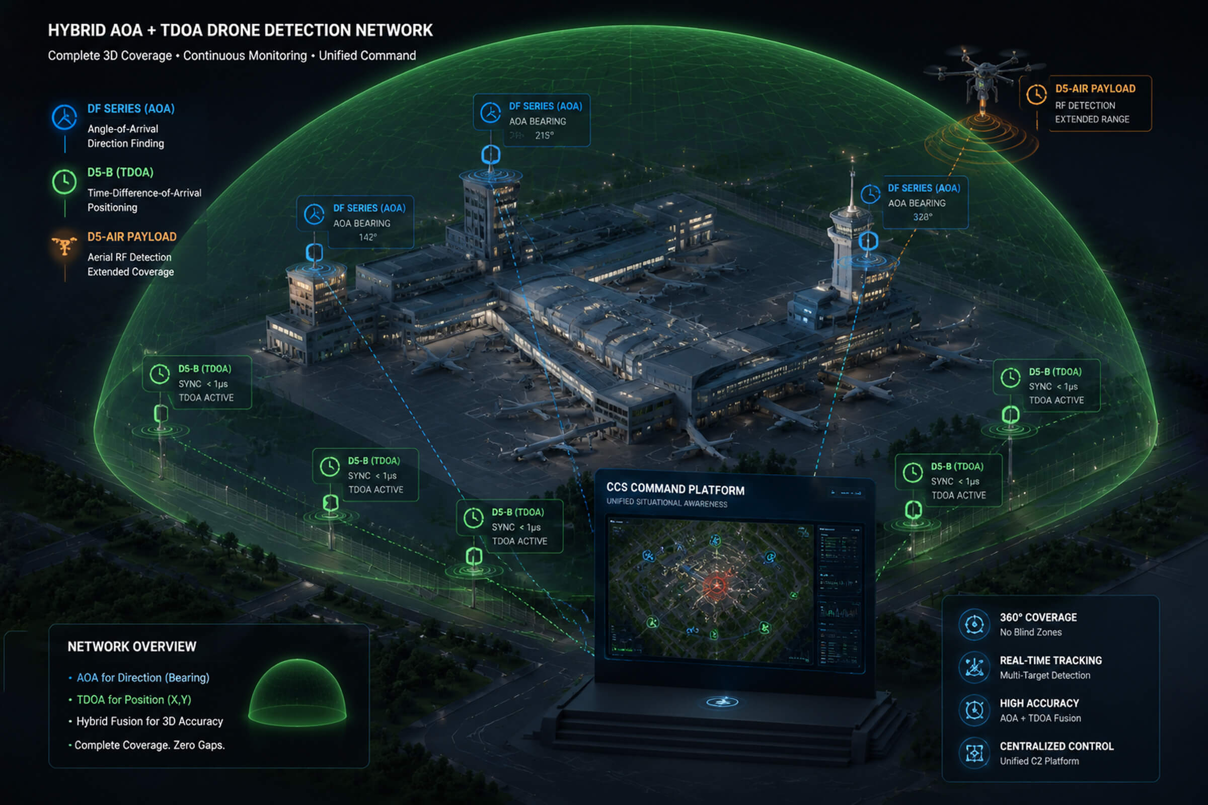
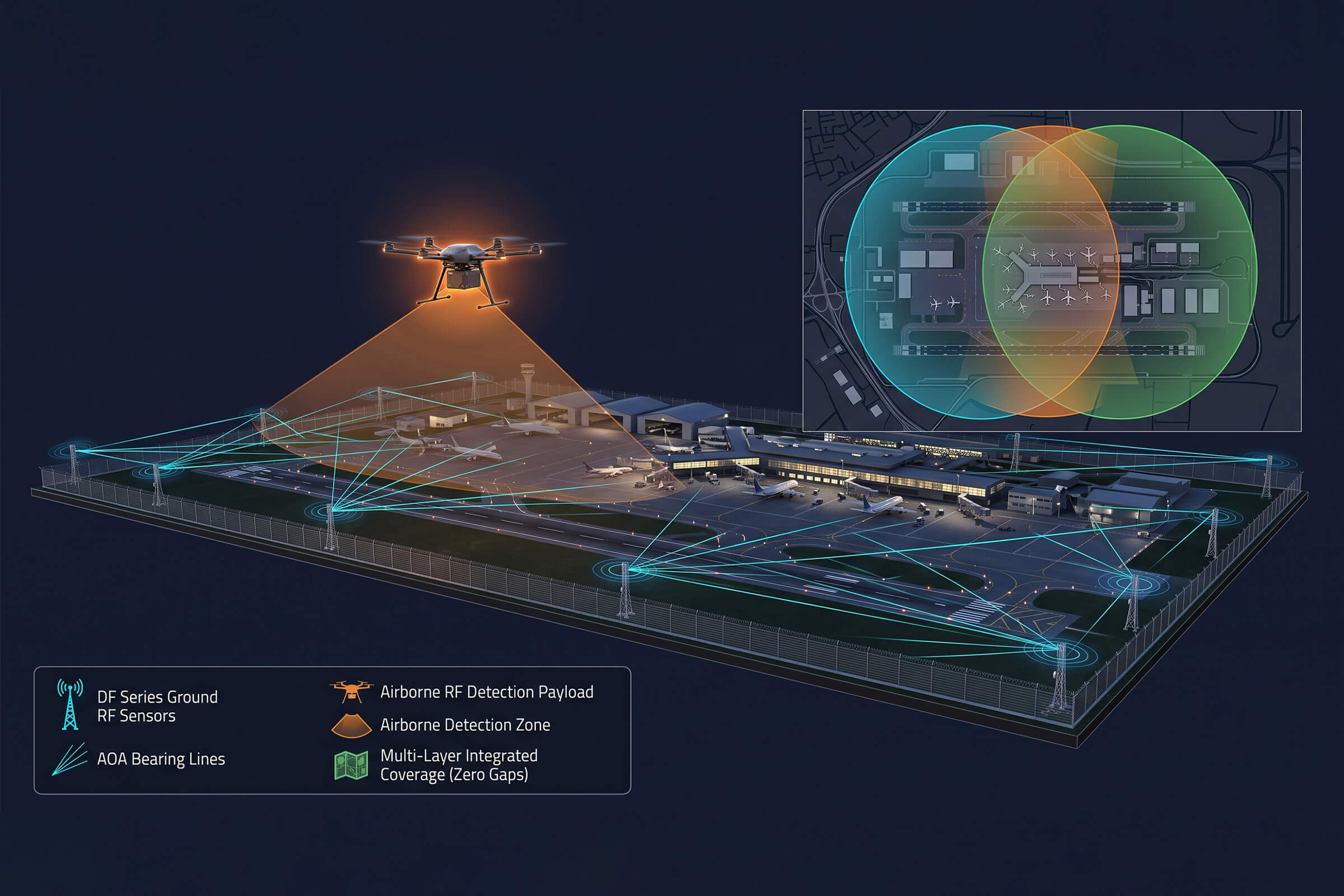
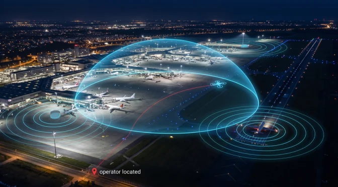
Networked TDOA also solves the coverage geometry problem that single-sensor systems cannot. A single detection unit, however capable, has a field of view. The perimeter is larger than any one sensor can cover. The approach vector depends on wind direction, the operator’s position, and the drone’s flight mode. With three or more TDOA receivers placed around the airport, the detection volume is continuous. Overlap between receivers means a drone cannot transit from one coverage zone to another without being tracked the entire way.

Beyond pure detection, TDOA gives you a trajectory. By computing position fixes at short time intervals, under two seconds in a well-engineered system, the network reconstructs the drone’s flight path from takeoff to the current position. That trajectory has a start point. The start point is the operator. On a command screen, it appears as a red dot with a GPS coordinate. Security can dispatch to that coordinate while the drone is still in the air. That is the operational difference between TDOA and any single-channel detection method.

What D5-B brings to an airport perimeter

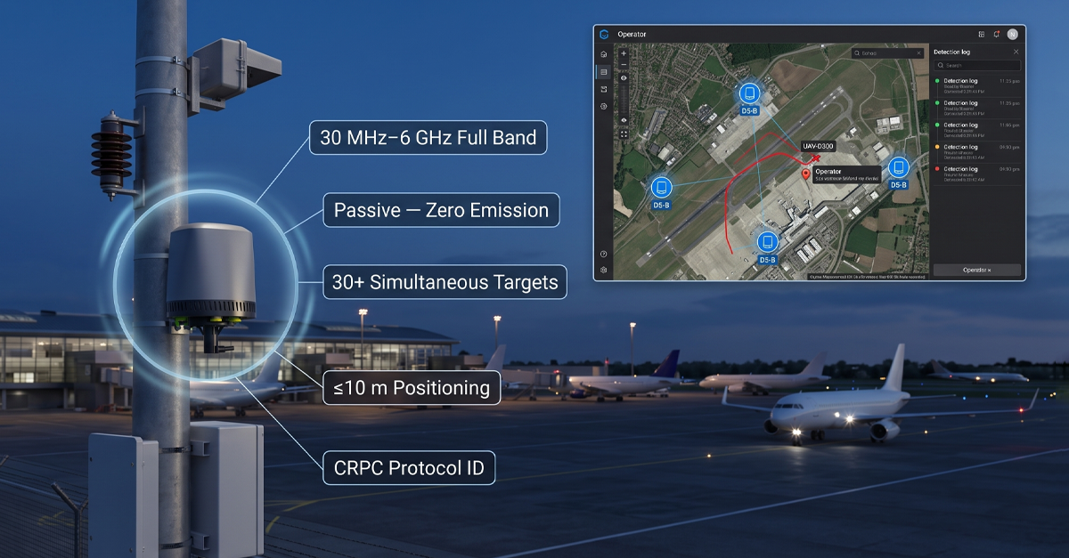
The D5-B is a TDOA detection and positioning node built for exactly this use case. It is a compact unit, 224 millimeters in diameter, 287.5 millimeters tall, three kilograms, that combines wideband passive RF reception with the CRPC protocol-cracking engine. The form factor matters at an airport, where every installation point needs to go through facilities approval, structural surveys, and aesthetic review. A three-kilogram unit with an IP66 rating can be mounted on an existing light pole, a terminal roof edge, or a perimeter fence post without a concrete pad and a crane.

The D5-B listens across the full 30 MHz to 6 GHz band. That span covers every commercial drone control frequency in current use, every common Wi-Fi drone band, and the custom FPV frequencies that traditional narrowband detectors miss. A single D5-B unit detects more than thirty drones simultaneously. When three or more units are networked together, they deliver directional positioning and full trajectory tracking for every target.

The positioning accuracy is under ten meters RMS. That means the system can distinguish an operator standing at the airport fence from an operator standing at a warehouse across the road. For the security team deciding whether to dispatch an intercept vehicle, a ten-meter circle is actionable. A five-hundred-meter arc from a single directional sensor is not.

The CRPC engine inside every D5-B adds a layer that TDOA alone cannot provide: identification. The receiver decodes the communication protocol between the drone and its remote controller. It extracts the drone’s model, serial number, and the home-point GPS coordinates that most consumer and commercial drones transmit as part of their standard telemetry stream. It also extracts the operator’s location from the home-point data, giving a second independent position fix that cross-checks the TDOA triangulation.

The identification runs through a drone library that covers more than 98 percent of the commercial market. DJI. Autel. Parrot. Hubsan. FIMI. Custom FPV builds with aftermarket transmitters. Wi-Fi drones that use standard 802.11 chipsets. DIY platforms assembled from off-the-shelf flight controllers. The library knows them all. The AI-RPC self-learning pipeline adds new signatures as new drone models enter the market.

Once identified, the D5-B classifies. A white-listed inspection drone operated by the airport maintenance team gets no alarm. A white-listed delivery drone on a registered commercial route gets a logged pass. An unknown drone with no registration ID, no white-list entry, on an approach vector toward the active runway threshold gets an immediate alert with position, trajectory, model, and operator location. The operator clicks ‘mark black.’ Every D5-B on the network now treats that specific drone’s electronic fingerprint as hostile.

The unit operates autonomously around the clock. No operator needs to watch a screen at 3 a.m. for the system to function. Classification, trajectory tracking, and alerting run automatically. The operator engages when the system flags a threat, not before. For an airport security operations center that already monitors dozens of camera feeds, access control systems, and fire alarms, an additional sensor system that does not demand constant attention is a requirement, not a luxury.

What ICAO’s interoperability push means for the hardware you buy today

The Krakow workshop’s clearest signal was about interoperability. ICAO wants UTM platforms to query national drone registration databases in real time. That means the detection layer, the sensors at the airport perimeter, needs to do more than flash an alarm light when a drone appears. It needs to output identification data that a UTM platform can cross-reference against a registration database.

Frequency-based detection cannot provide that data. Knowing that a signal is present on 2.4 GHz tells a UTM system nothing about which specific drone is transmitting. Protocol-level identification, the kind CRPC delivers, extracts the serial number and the telemetry data that the drone itself is broadcasting. That serial number is the bridge to the registration database. That bridge is what ICAO’s interoperability framework requires.

Without protocol-level ID in the detection layer, the UTM operator sees a dot on a screen labeled ‘unknown contact.’ They cannot tell a registered survey drone that drifted slightly off its flight plan from an unregistered drone on a collision vector. The Krakow workshop identified exactly this gap as the priority to close. Detection hardware that cannot provide identity-level data to the UTM platform is detection hardware that does not meet the emerging ICAO standard.

This is not speculation about what a future regulation might ask for. ICAO will release the risk management guide this year. Member states will write their procurement specifications against it. An airport that installs a detection system in 2026 or 2027 will live with that system for five to ten years. If it cannot output protocol-level identification to a UTM platform, the system is already on a path to obsolescence.

Beyond the airport fence: where networked TDOA makes sense

The TDOA networking model is not only for airports. Any site where the protected perimeter is large, irregular, or embedded in an urban RF environment benefits from passive networked detection. A stadium during a match. A government complex spread across multiple buildings. A correctional facility where the drone approach can come from any direction, and the threat is contraband delivery. A waterfront port facility where the approach vector is over water, with no terrain to constrain detection geometry.

In each of those sites, the same physics applies. A single sensor has a field of view. A network has a coverage volume. TDOA gives you the operator’s location alongside the drone’s position. CRPC tells you what the drone is and what it is doing. The D5-B form factor, small, light, IP66, low power, means the network can go where the threat geometry demands, not where the installation budget permits.

The ICAO framework may target civil aviation first, but the hardware model it describes, passive, networked, interoperable, protocol-aware, is the same model that protects any site where the cost of a drone incursion is measured in millions per hour instead of dollars per incident.

The Krakow signal is clear

ICAO does not regulate drone detection hardware. But it sets the framework that procurement offices use to write their specifications. The Krakow workshop made three things clear. One: the drone threat to civil aviation is not leveling off. It is rising, and ICAO’s own language now reflects the urgency airports have felt for years. Two: the response has to be coordinated across detection equipment, aviation regulation, and digital infrastructure, UTM, registries, and threat intelligence. Three: interoperability between the detection layer and the UTM layer is not a nice-to-have. It is the recommendation that will drive procurement decisions for the next decade.

For airports, the hardware implication is practical. Deploy detection that does not add to the RF noise floor. Detection that locates both the drone and the operator with actionable precision. Detection that identifies the specific drone and feeds that identity data into the UTM platform. Detection that does all of this autonomously, around the clock, with every event logged and timestamped for the incident report that ICAO recommends feeding into national intelligence pipelines.

TDOA plus CRPC delivers that package. The D5-B is one implementation of it: a three-kilogram, IP66-rated node that covers 30 MHz to 6 GHz, positions to under ten meters, identifies 98 percent of the commercial drone market by protocol fingerprint, and networks with its neighbors to cover the full perimeter. It is the kind of detection layer that slots directly into the ICAO framework, the Krakow workshop previewed. When the new risk management guide drops, airports that already have passive, networked, protocol-aware detection in place will be ahead of the specification. Airports that do not will be writing RFPs to catch up.

NATO’s $40 Billion C-UAS Pledge: What It Means for Counter-Drone Procurement

At the Ankara Summit, 32 NATO allies agreed to spend more than $40 billion on counter-drone capabilities over five years. Here is how the C-UAS Marketplace changes procurement, which technologies will get certified, and what the spending wave means for the industry.


Introduction

On July 7, 2026, NATO leaders wrapped up the Ankara Summit with a figure that reset the counter-drone industry’s sense of scale. Thirty-two member nations committed more than $40 billion to C-UAS capabilities through 2031. They also announced a C-UAS Marketplace, a certification-led procurement framework that lets any member buy from any certified vendor without running their own tender process. And they set a target to train five times more drone operators by the end of 2027.

This is not a report. It is a funded mandate with a procurement vehicle attached. Stack it on top of the World Cup $250 million C-UAS deployment in the US, and 2026 is the year counter-drone graduated from a niche military program to a structured, certifiable, multi-billion-dollar procurement category.

Here is what the NATO announcements mean on the ground. Who benefits first. What technologies are best positioned for certification. And what procurement teams should be thinking about right now.

The numbers: $40 billion over five years

The $40 billion figure covers the full capability chain: detection, tracking, identification, neutralization, command and control, and operator training. It is not a single NATO budget line. Each member nation funds its own procurement against agreed capability targets. But the C-UAS Marketplace changes how that money actually flows.

Before the Marketplace, if Lithuania wanted a counter-drone system, it wrote its own RFP, ran its own evaluation, conducted its own trials, negotiated its own contract. A vendor that qualified in Estonia had to go through the same gauntlet again in Portugal. The Marketplace flattens that. A system that passes NATO C-UAS certification becomes available to all 32 members through a shared procurement mechanism. One certification. Thirty-two markets. That is the structural shift behind the spending number.

Other items from the Ankara communique:

  1. NSPA signed several hundred million euros in surveillance drone contracts.
  2. Belgium and the Netherlands signed an MOU for joint air defense system procurement. That is two midsize NATO members pooling demand to get better terms from suppliers.
  3. Five times more trained drone operators by end of 2027. Hardware without operators is a very expensive paperweight, and NATO knows it.
  4. A dedicated C-UAS working group under the Defence Investment Pledge will standardize threat assessment and certification criteria across all 32 nations.

The C-UAS Marketplace: certification becomes a license to sell

The Marketplace is the structural piece that matters most. NATO already runs similar frameworks for ammunition and communications equipment. Applying that model to counter-drone means the alliance has decided C-UAS is a standardized domain, not a collection of one-off experiments. That changes what vendors build and how buyers buy.

Here is what certification will likely evaluate:

  1. Detection range and false alarm rate against NATO-specified drone types. Not just DJI consumer models. The test set will include military fixed-wing UAS, loitering munitions, and multi-drone swarm scenarios.
  2. Response effectiveness: for jammers, effective range and frequency coverage. For spoofing, GNSS constellation support and spoof accuracy. For kinetic intercept, hit probability and safe standoff distance.
  3. Interoperability: the system feeds data into NATO-standard C2 platforms using LINK-16, STANAG 4586, or equivalent. A closed proprietary dashboard is dead on arrival.
  4. Electronic warfare resilience: certified systems operate when the other side jams back. Self-protection and graceful degradation under EW attack are baseline, not optional.
  5. Deployment and sustainment: mean time between failures, field repair procedures, spare parts availability across member nations with different logistics chains.

For a C-UAS vendor, NATO certification is not a marketing badge. It is a procurement key. Without it, you sell to individual nations, one RFP at a time, each with its own qualification cycle. With it, any NATO member can place an order through the Marketplace without repeating the evaluation. That turns a fixed certification cost into a 32-nation addressable market.

Who benefits first from NATO C-UAS certification

European C-UAS companies are the most immediate winners. They are physically inside NATO member states. They have existing relationships with national procurement offices. Their installed base makes field validation faster because the testing authority can visit an active deployment rather than arranging a bespoke trial from scratch.

DroneShield supplies RF detection and handheld jammers with military deployments across several NATO countries. Dedrone runs RF and radar detection at airports and government sites throughout Europe. Sentrycs does protocol-based identification and takeover, with prison and infrastructure deployments that give it operational data no lab test can replicate. Robin Radar makes bird and drone radar for European military airfields. MBDA and Thales bring missile-based kinetic C-UAS from the air defense side, systems that already conform to NATO munitions standards.

The wildcard is non-European vendors whose technology fills gaps that the European incumbents do not address well. Protocol-level detection. OEM components that drop into existing radar stacks. Modular form factors built for third-party integration. Those are three entry vectors where NATO certification creates a path that did not exist before the Marketplace existed.

What the NATO checklist is missing: identity

The certification criteria as currently described cover range, frequency, EW hardening, and C2 interoperability. All of those are necessary. None of them answer the question that drives every engagement decision: who is flying the drone?

A radar tells you there is an object at 4.2 kilometers, bearing 127 degrees. It cannot tell you whether it is a DJI Mavic flown by a local hobbyist or a fixed-wing military drone executing a pre-programmed recon route. An RF jammer can break the control link. It cannot tell you the operator’s location or the drone’s serial number. Identity is what separates a diplomatic incident from a justified engagement. Shoot down a tourist’s drone over a NATO base, you have a press problem and a foreign ministry phone call. Let a military drone finish its recon pass, you have an intelligence failure. The operator needs to know which one it is before pulling the trigger.

Protocol-level detection addresses this gap directly. Our team at LZ TECH built Cognitive Radio Protocol Cracking to pull the drone’s electronic identity out of its communication signal. The CRPC engine decodes the bitstream between the drone and its controller. Known model in the fingerprint database? You get the serial number, the home point GPS, and the current flight mode, all without emitting a single watt. Unknown model? The system logs the signal pattern for forensic analysis and blacklisting.

For a NATO operator, that changes the escalation timeline. Radar picks up the target at maximum range. Protocol-level RF identifies it while it is still inbound. By the time EO/IR gets a visual lock, the operator already knows the drone type and whether this is threat or nuisance. Under the C-UAS Marketplace framework, identification capability needs to be a certification criterion, not an afterthought added in version two.

Modular C-UAS: built for NATO procurement logic

NATO certification favors modularity. A system that only works as a standalone stack forces each new member nation to rip out whatever they already have and start over. A system designed to plug into existing infrastructure, third-party radar, someone else’s C2, a different vendor’s cameras, gets deployed faster and clears procurement review faster.

Our Detection and Defense System is built on that logic. Passive RF detection plus protocol analysis, no emissions, no spectrum interference. The detection module takes a feed from an existing radar. The RF identification data feeds into a NATO-standard C2 platform. The DFJ series jammer accepts triggers from a third-party detection system. Each component earns its place in an existing stack instead of demanding a clean slate.

For vendors who already sell sensors into NATO, the protocol analysis engine works as an OEM component. Drop it into a radar vendor’s C-UAS platform to add identity intelligence to existing track data. The radar company keeps the customer relationship. The protocol engine provides a capability layer they would otherwise spend years building. That kind of modular integration is how you get through NATO certification faster, because you are solving a specific gap rather than duplicating something already deployed at 32 different scales across 32 different budgets.

The CRPCS software platform unifies the feeds into a single operator interface. The CCS command platform handles multi-site monitoring with GIS overlay and role-based access that maps onto NATO command hierarchies. The architecture is designed for interoperability, not lock-in. That is the difference between a system NATO procurement officers can evaluate once and a system they have to renegotiate for every new deployment site.

Five times the operators: the bottleneck NATO is naming out loud

The fivefold operator training target matters as much as the $40 billion. Every C-UAS deployment hits the same wall eventually: you can buy all the hardware you want, but if there are not enough trained people to interpret the data, the system underperforms. NATO putting operator headcount into the same communique as the dollar figure means they have seen this play out in Ukraine, in the Middle East, at every exercise.

The training gap changes what kind of C-UAS system gets purchased. A system that needs a full-time operator staring at a screen for every sensor feed does not scale to 32 nations running multiple sites each. A system that automates classification, suppresses false alarms at the sensor level, and only escalates to the operator when the AI is uncertain, scales. That is the architecture shift the operator target forces.

Autonomous detection and tracking, like the VAR300, handles routine airspace monitoring without an operator babysitting the screen. Protocol-level identification automates the model and serial number lookup that currently requires a human analyst. Automated alarm routing through the CCS platform sends only actionable alerts to the operators who need them, at the security level they are cleared for. That is the human factors piece of the NATO certification picture that procurement teams should be considering alongside the range and frequency specs.

The bottom line

NATO put $40 billion and a procurement mechanism behind counter-drone technology. That reshapes the entire industry. Certification replaces individual RFPs as the filter. Interoperability replaces proprietary stacks as the baseline expectation. And the fivefold operator target confirms that even the best hardware gets bottlenecked by the number of people qualified to run it.

For C-UAS vendors, the window is the next 18 months. Get into the certification pipeline while the criteria are still being defined. For NATO procurement teams, the task is defining those criteria to cover the full kill chain without leaving gaps that the threat has already evolved past.

Detection at range is table stakes now. Identification under pressure is what separates systems. At $40 billion, spending that budget on radar and jamming alone, without knowing who is at the other end of the control link, is leaving the most expensive question in counter-drone unanswered.

After the JetBlue Drone Strike: Inside the World Cup’s $250M C-UAS Deployment

The 2026 FIFA World Cup is the largest civilian counter-drone deployment ever attempted. Here is what the tech stack looks like, who is building it, and what airports and stadiums should learn from it.


Introduction

On the morning of June 29, 2026, a JetBlue Airbus A321 was on final approach into JFK. At roughly 3,000 feet, something hit the aircraft. The crew reported a drone strike. The plane landed without incident. Inspection found no airframe damage. If confirmed, it would be the first documented collision between a commercial airliner and a drone in US airspace.

The same day, a helicopter pilot near JFK nearly collided with a large remote-controlled aircraft. Three days earlier, a United 737 with 111 passengers reported a drone at close range on final approach to Newark. Since the World Cup started, the FBI and FAA have confiscated over 500 drones from restricted airspace across 11 US host cities.

This is not random. Big events pull in crowds, cameras, and attention. They also pull in drones. Fans filming from above. Content creators chasing viral footage. People who do not bother checking NOTAMs. The World Cup has turned into the most ambitious civilian counter-drone operation ever run. We are watching a live experiment in what happens when a country treats stadium airspace like the security problem it actually is. The lessons are already piling up for airports, infrastructure operators, and any venue planning security for 2027 and beyond.

A drone strike that almost happened

The JetBlue incident is not the first close call, and it will not be the last. The FAA logs more than 100 drone sighting reports per month at US airports. Most of them are not strikes. A pilot sees something at 1,500 feet. The tower logs it. Nothing else happens. But the gap between seeing a drone and hitting one is not as wide as it used to be.

What changed in June 2026 is density. Eleven US cities are hosting matches. Each venue pulls in tens of thousands of people per match day. Some of those people are flying drones. A few have commercial permits and know the rules. Most are hobbyists who either missed the memo about temporary flight restrictions or decided it did not apply to them. The FBI confiscated 500 drones in a matter of weeks. That tells you how big the gap is between what the rules say and what actually happens in the air.

Commercial aviation has been lucky so far. A drone going into a turbofan engine at 3,000 feet is nothing like a bird strike. Bird turns to pulp. Lithium battery burns. Engine certification tests do not cover burning batteries. The industry has known about this risk for years. What the World Cup deployment proves is that someone finally put real money behind doing something about it.

The World Cup security stack: what $900 million buys

The 2026 World Cup covers three countries, 16 cities, 48 teams, and 104 matches. The US Department of Homeland Security classified it as a National Special Security Event, the same designation used for presidential inaugurations and the Super Bowl. That label unlocks federal money and multi-agency authority that no private venue operator could piece together on their own.

The money:

  1. $625 million from FEMA through the FIFA World Cup Grant Program for general security across 11 US host cities.
  2. Another $250 million just for counter-UAS hardware and deployment. That is a dedicated line item, not a sub-account of the general security budget.
  3. Motorola Solutions is the prime integrator. SkySafe is the C-UAS technology partner running the drone-specific hardware and software.
  4. The command structure ties together FBI, FAA, local police, and emergency management into a shared airspace picture.

Add it up and you are approaching $900 million. $250 million for counter-drone alone is more than most countries budget for their entire annual military C-UAS program. This is not a pilot. It is a full deployment running under the brightest spotlight available.

The tech splits into three layers. Each addresses a different link in the kill chain.

Detection

Surveillance radar plus RF signal identification plus AI alerting. Radar finds the object. RF tells you if it is a drone, and what kind. The AI cross-checks both feeds to keep the false alarm rate down. Without that handshake, a radar track is just a dot on a screen. With it, you know whether that dot is a DJI Mini 4 or a confused gull.

The detection challenge changes with the venue. A stadium in downtown Los Angeles has different RF noise than an open-air field in Miami. Radar clutter from buildings and terrain varies wildly. Run the same sensor setup in all 11 cities and your false alarm rate will be all over the map. The World Cup stack handles this by tailoring sensor combinations to each venue’s actual electromagnetic and physical environment.

Countermeasures

Jamming, GPS spoofing, and physical interception form the response tier. Jamming cuts the drone’s link to its operator. Spoofing feeds it bad GPS coordinates to steer it away from the venue. Which one you use depends on where you are. Inside a stadium bowl, you need directional jamming that hits the target without taking down every phone in section 203. In open air around the venue perimeter, spoofing can redirect a drone without triggering a radio blackout.

There is a legal angle too. FAA Remote ID rules went into full effect in 2024. Drone manufacturers now have to broadcast identification data. On paper, that makes detection easier. In practice, enforcement is slow. The 500-seized-drones number tells you a lot of operators are flying without Remote ID, or with it disabled. The countermeasure layer has to assume non-compliant drones are the norm, not the exception.

Airspace control

The FAA drew the tightest no-fly zones in World Cup history. Every venue gets a 3-nautical-mile radius, 3,000-foot ceiling. Fan zones get 1 nautical mile, 1,000 feet. Break the rule and you are looking at up to $100,000 in civil fines, your equipment gets confiscated, and federal criminal charges are on the table.

Enforcement is where it gets messy. Temporary flight restrictions only work if drone operators read and follow NOTAMs. The 500 confiscated drones tell you a lot of people either cannot, will not, or actively choose not to. The rulebook deters commercial operators who value their FAA ticket. For everyone else, detection and countermeasures are the only layers that stop an incident.

What airports need vs. what stadiums need

Airports and stadiums both worry about drones, but their detection problems are not the same thing. The differences matter when you are picking hardware.

An airport has approach corridors that stretch miles from the runway. The system has to cover volume, not just a perimeter. A drone at 2,500 feet three miles out on the glide path is a threat. The same drone at 2,500 feet over a stadium is an annoyance looking for a good angle. The sensor layout, the alert thresholds, and the response protocol all change with the geometry.

Stadiums have a different headache: crowd density. A directional jammer inside a stadium has to deal with tens of thousands of phones, broadcast rigs, wireless production gear, all humming in the same frequency bands as drone control links. The RF environment inside a stadium during a match is noisier than an airport tower band on its busiest day. Precision beats raw power every time here.

The World Cup uses different configurations of the same sensor types for both environments. Airports get long-range radar with EO/IR for visual confirmation on approach. Stadiums get shorter-range radar tuned for angular resolution, to pick out targets coming out of urban clutter, paired with RF detection built for high-interference settings.

For sites that fall between these extremes, military bases, ports, large industrial facilities, the modular approach works better. Add sensors as the threat picture changes. Start with RF detection. It covers the most common drone types and does not broadcast anything. Add radar and EO/IR when you need active sensing for autonomous drones that do not emit radio signals.

Why the World Cup model matters for system builders

Motorola and SkySafe are building the World Cup system as an integrated stack under a single prime contract. That approach works when you have nine-figure budgets and one procurement authority. Most counter-drone deployments do not start from that position.

The more common scenario: an airport already runs a perimeter radar from vendor A. They add RF detection from vendor B because that tender came up separately. A year later, they tack on an EO/IR camera from vendor C. Three systems. Three dashboards. Three alert streams. The operator has to fuse the data in their head. That mental fusion step is where protocol-level detection earns its keep.

LZ TECH designed its detection modules and the CCS command platform to drop into existing security stacks. The detection module takes a feed from a third-party radar. The RF identification data feeds into someone else’s C2 platform. The jammer accepts triggers from a different vendor’s detection system. This is not the Motorola single-vendor integration model. It is for adding capability to systems already deployed and already budgeted.

The World Cup proves the architecture works. The next piece is making it modular enough and affordable enough that an airport or stadium operator can adopt it without tearing up their procurement plan.

The detection layer most World Cup stacks are skipping

There is a gap in the World Cup model worth flagging. The detection layer as described, radar plus RF identification, works for commercial drones. It spots DJI, Autel, Parrot. It picks up DIY FPV drones by their video transmission signature. What it does not do is extract the data payload.

Protocol-level detection goes one layer deeper than signal presence. It decodes the communication protocol between the drone and its controller. That gives you the drone’s electronic ID, real-time telemetry including GPS, and in some setups the home point where the operator is standing. You go from ‘there is a drone somewhere in the sector’ to ‘Mavic 3, serial number X, operator northeast parking lot.’

This is what Cognitive Radio Protocol Cracking was built for. Our team developed CRPC to close the gap between passive RF detection and active countermeasures. The engine pulls the ID bitstream from the drone’s control signal and matches it against a fingerprint database. Known drone model? Identified in seconds. Unknown model? The system logs the signal pattern for later analysis and blacklisting.

For a venue running the World Cup detection stack, adding protocol-level intelligence cuts the time from detection to classification. Radar gives early warning. EO/IR gives visual confirmation. Protocol-level RF gives the drone’s identity without waiting for a camera lock. When your response window is seconds, that matters.

Our Detection and Defense System combines passive RF detection with protocol analysis and integrates with phased-array radar where active sensing is needed. The TR100 packages radar and EO/IR into one unit with radar-guided tracking. The VAR300 runs autonomous detection and tracking for sites that need a sensor that works without someone watching the screen. The CRPCS software platform ties detection, classification, and response into one interface.

The Multi-tech Fusion Detection Solution is built on this layered model. No single sensor gives you everything. Radar gives range. EO/IR gives visual ID. RF detection gives signal fingerprinting. Wire them together and you have a system that detects, identifies, tracks, and hands off a target to jamming or spoofing without an operator playing air traffic controller.

For the Ruyi jamming system, CRPC 3.0 adds a capability most venue security plans are not even asking for yet: protocol-level takeover. After identification, Ruyi rebuilds control-layer data streams to send its own flight commands to the target. Redirect. Land. Hold position. No kinetic interception, no debris raining into the stands. For a stadium deployment, that changes the risk calculus entirely.

The bottom line

The World Cup is dropping a quarter-billion dollars on counter-drone security because the threat is not hypothetical anymore. The JetBlue near-miss at JFK is the headline that makes the spending look obvious after the fact. When a passenger jet and a drone share the same 3,000-foot approach corridor, something was already broken before the pilot saw it.

For airports, the lesson from June 2026 is simple: drone detection is infrastructure. Same budget category as runway lighting and perimeter fencing. Not a discretionary line item. The World Cup showed what properly funded deployment looks like. The question is not whether to install counter-drone systems. It is which architecture fits your budget, your airspace shape, and how your ops team works.

For stadiums and large venues, the World Cup is about to become the reference deployment. Your insurance carrier will have read about the JetBlue incident. Your next RFP will cite the World Cup model. The standard is getting set in public, right now, with the stakes higher than ever.

For the C-UAS industry, the window that opens after July 19 is wide. The World Cup proved the architecture: layered detection, networked response, real-time coordination. The next step is making that architecture work for venues that do not have FEMA funding and a Motorola contract. Modular systems, protocol-level intelligence, integrated hardware and software, that is where the real deployment volume lives.

LZ TECH to Exhibit Counter-UAS Portfolio at Farnborough International Airshow 2026

With operations spanning 60+ countries and a partner network of over 6,000 distributors and integrators, LZ TECH arrives at Farnborough as one of the counter-drone industry’s busiest international operators.


Farnborough 2026: the stage

LZ TECH will exhibit at the Farnborough International Airshow from July 20 to 24, 2026, at the Farnborough International Exhibition and Conference Centre in Hampshire, United Kingdom. Held every two years, Farnborough is one of the three largest aerospace and defense trade events globally, alongside Paris and Dubai. The 2026 edition brings together over 1,700 exhibitors and approximately 150,000 trade visitors across five days of exhibits, flight demonstrations, and industry forums covering defense, aerospace, space, and security.

For a counter-UAS company, the attendee mix is what matters. Defense procurement delegations from Europe, the Middle East, and Asia-Pacific attend Farnborough as buyers with budgets, not browsers. Airport operators, border security agencies, and infrastructure protection managers walk the halls alongside air force and army program offices. LZ TECH will have live hardware on display: RF detection, directional jamming, protocol-level identification, and the integrated CRPCS and CCS platform, all running in real time at the booth. The company’s engineering team will run controlled detection-and-response sequences so procurement officers can see the full timeline: signal acquisition, protocol decode, operator location, and neutralization decision, all inside five seconds.

The product demonstrations are structured around specific operational scenarios. An airport perimeter where a drone approaches from outside the fence. A stadium event where multiple consumer drones appear simultaneously. A border crossing where the drone type and origin need to be established before escalation. Each scenario runs on the same hardware stack, configured differently. The point is to show that one architecture can cover multiple mission profiles without procurement teams buying a separate system for each.

Global footprints: 60+ countries, 6,000+ partners

LZ TECH arrives at Farnborough after two years of steady international growth. The company now serves customers in more than 60 countries and regions, backed by a partner network of over 6,000 distributors, system integrators, and resellers. This is not a map of inquiry forms. These are active accounts, with product in the field and local support channels in place.

In the first half of 2026 alone, the company completed large-scale system deliveries across multiple continents. Airports in Southeast Asia. Government facilities in the Middle East. Correctional institutions in South America. Energy infrastructure in Central Asia and even the FIFA security project in Mexico City. Each deployment generates operational data that feeds back into the product cycle. Each region develops its own reference customers, which drives follow-on orders within the same geography.

A delivery to Thailand’s Grand Palace complex shows how this works in practice. The site needed passive detection that would not interfere with tourist mobile networks, portable jammers deployable without permanent installation approvals, and a command interface in the local language. After commissioning, that reference opened conversations with other government sites in the region. At a Canadian energy infrastructure site, the Detection and Defense System was integrated into an existing perimeter security stack. In Malaysia, the national space agency MYSA ran evaluation trials that produced technical feedback now incorporated into the product roadmap. A single airport deployment leads to more. A border installation generates inquiries from neighboring countries with the same threat profile.

Behind the deployment numbers is a 10,000-square-meter manufacturing and service center, staffed by more than 100 professionals across production, quality assurance, testing, and post-sales support. Every unit shipped goes through four gates before export packaging: burn-in testing for long-term stability, RF performance calibration with signal integrity verification, full-system end-to-end functional testing, and a final quality inspection that checks both hardware and software revision levels.

The tour schedule over the past twelve months reads like a counter-UAS market map. Germany. Turkey. Saudi Arabia. UAE. Brazil. Malaysia, etc. At each stop, the booth generated new distribution agreements, technology integration partnerships, and direct procurement interest from government end-users. The throughline is the same everywhere: demand for counter-drone capability is accelerating, and procurement teams are getting more specific about what they need, which frequencies, which drone types, which integration protocols.

Europe: a channel structured for defense procurement

Europe right now is the most structured counter-drone market anywhere. NATO’s $40 billion C-UAS pledge through 2031. The C-UAS Marketplace certification framework opens 32 national procurement offices to any vendor that passes the certification criteria. A growing number of national programs, German critical infrastructure C-UAS, British Army and Home Office drone defense, Polish border fortification, and Belgium-Netherlands joint air defense procurement. Europe has moved from trials to operational programs, and that changes the kind of company that gets the contract.

LZ TECH has been growing European distribution channels to match that tempo. The network now spans defense integrators, security system resellers, and specialized counter-drone consultants in Germany, the United Kingdom, Turkey, Belgium, the Netherlands, and Poland etc. The model is a local partner plus the LZ TECH technology stack. Partners handle local language, certification paperwork, import logistics, and ongoing customer relationships. LZ TECH provides the detection hardware, the protocol analysis engine, the jammers, the command software, and the integration engineering that gets the system talking to whatever C2 the end-user already runs.

The UK market, in particular, is a strategic focus for channel development. It is one of Europe’s largest defense spenders and one of the most open to counter-drone technology from suppliers outside the traditional European defense primes. Publicly announced programs from the British Army, the Home Office, and multiple airport operators signal sustained procurement demand. For any counter-UAS vendor, the UK is a reference market: systems that earn deployment here tend to see follow-on interest across the Commonwealth and from NATO members that track UK procurement as a benchmark.

Belgium and the Netherlands formalized their joint air defense procurement at the NATO Ankara Summit. Germany is running parallel C-UAS evaluation programs with budgets tied to infrastructure protection. Poland is layering detection and interdiction systems along its eastern border. Each of these programs requires hardware that is locally supported, certifiable, and able to plug into existing command-and-control infrastructure. The European channel is built to deliver that package, not just move boxes across a customs line.

Products on the booth: what is driving demand

LZ TECH brings its full counter-UAS stack to Farnborough. Detection. Identification. Neutralization. Command and control. Fixed-site, vehicle-mounted, portable, and OEM module form factors. Here is what visitors will see running live.

Detection and identification

The Detection and Defense System pairs passive RF detection with protocol-level analysis. It detects drone signals without any active emission, identifies the drone model and serial number through a protocol decode of the communication between the drone and its controller, and extracts the operator’s home-point GPS coordinates from the signal stream. The system handles commercial drones, modified consumer platforms, and DIY FPV builds that pure frequency-based detection routinely misses.

For sites that need active sensing, the TR100 combines phased-array radar and EO/IR into one integrated sensor head. Radar detects and tracks the target. The camera slews to the radar track and delivers visual confirmation. The VAR300 handles autonomous detection and tracking for installations that need 24-hour coverage without a full-time operator at the screen.

The protocol analysis engine deserves particular attention. Most RF detection systems tell you a signal is present on a given frequency band. The LZ TECH engine goes further: it decodes the bitstream between the drone and its controller, extracts the serial number and flight parameters, and maps the operator’s home-point GPS location onto the command interface. For law enforcement, that turns a radar blip into an actionable address. For a military base, it turns an unknown contact into a known aircraft model with a known flight mode. The database now covers over 200 drone models across DJI, Autel, Parrot, Hubsan, FIMI, and custom FPV platforms. New signatures are added continuously through the AI-RPC self-learning pipeline, which updates the fingerprint library from field data collected across the deployed fleet.

Neutralization

The DFJ series jammers cover drone control and navigation frequency bands. Directional jamming lets the operator target a single drone while keeping surrounding communications running. At an airport, a prison, or a stadium, that is not a nice-to-have. Emergency services, air traffic control, and civilian mobile networks cannot go dark every time a drone shows up.

For situations where jamming is the wrong tool, the protocol-level takeover system delivers a different option. After the CRPC engine identifies the drone, the system reconstructs control-layer data streams and issues flight commands to the target. Redirect it away from the protected site. Force a controlled landing. Hold it in place until a response team gets eyes on. No kinetic debris. No spectrum damage. European law enforcement agencies that operate in dense urban areas see this as a game-changer for situations where every other response option carries unacceptable collateral risk.

Command and control

CRPCS software ties detection, classification, and response into a single operator interface. The CCS command platform scales that to multi-site monitoring with GIS overlay, sensor health dashboards, alarm timeline, and role-based access control that maps onto civil defense command structures. Both platforms accept third-party sensor inputs. If a customer already has radar from one vendor and cameras from another, CRPCS integrates the feeds instead of forcing a rip-and-replace.

OEM modules: protocol intelligence as a component

The protocol analysis engine ships as a compact OEM module for integration into existing radar, EO/IR, or C2 platforms from other manufacturers. A radar company that sells into NATO can add drone identification to its product line without spinning up a radio protocol analysis team from scratch. A C2 vendor can offer identity-level threat classification without developing signal intelligence expertise in-house. For the European defense market, where procurement preferences often favor existing supplier relationships, the OEM route opens doors that a standalone counter-UAS system cannot reach on its own.

An active player in a market that waits for no one

The counter-UAS industry in mid-2026 is moving at a pace most outside observers underestimate. NATO certification frameworks are being drafted right now. World Cup C-UAS deployments are generating operational data. Airport procurement timelines are compressing from years to quarters. The companies that are not shipping products, exhibiting at shows, signing distribution partners, and deploying systems simultaneously across multiple regions are losing ground.

LZ TECH has been on the move. In the past twelve months, the company exhibited at defense and security trade fairs in Germany, Turkey, Saudi Arabia, the UAE, Brazil, Malaysia, and many other international markets. Each event produced distribution agreements, government contacts, and product feedback that goes straight into the engineering backlog. Farnborough extends that pattern into the largest audience the company has addressed, with defense procurement delegations from every continent in the same halls for five consecutive days.

The delivery pipeline tells the same story. High-volume orders shipped across multiple regions in the first half of 2026. A manufacturing infrastructure that scales from single-unit demonstrations to multi-site operational deployments and still hits the delivery date. A partner network that covers every major counter-drone procurement geography.

The feedback loop from the field shapes what gets built next. European customers want NATO-standard interoperability and spectrum discipline. Middle Eastern customers prioritize detection range and all-weather reliability. Southeast Asian customers need portability and fast deployment. The product line reflects each of those priorities because the engineering team hears it directly from the operators using the systems.

At Farnborough, LZ TECH is showing operational hardware, not a concept deck. The company is showing systems that are already deployed, already shipping, already generating operational data across 60-plus countries. For the buyers walking the halls in July, that is the conversation that matters.

Visit LZ TECH at Farnborough

LZ TECH invites Farnborough attendees to visit the booth for live demonstrations of RF detection, protocol-level identification, directional jamming, and the integrated CRPCS and CCS platform. Product specialists, integration engineers, and regional channel managers will be available for technical discussions and procurement inquiries throughout the show.

To schedule a meeting or reserve a demonstration slot during the event, contact the LZ TECH newsroom or reach out through the company’s official channels.


About LZ TECH

LZ TECH is a counter-UAS and security technology company that provides RF detection, protocol-level identification, jamming, and integrated defense systems for government, infrastructure, airport, and enterprise customers, and so on. The company operates a 10,000-square-meter manufacturing and service center and serves customers in more than 60 countries through a network of over 6,000 partners worldwide.

C-UAS Integration: How to Build a Multi-Sensor Drone Defense System


Introduction

If you have spent any time evaluating counter-drone systems, you have noticed something: every vendor has a product that does part of the job well. One vendor sells radar. Another sells RF detection. A third has the best cameras. A fourth built the jamming hardware. Nobody seems to have built the whole thing.

That is not a coincidence. Counter-drone defense is genuinely multi-technology by nature. No single sensor type covers all the threat scenarios you are likely to face. The integration problem is not a vendor failing. It is the fundamental challenge of the space.

This article is about solving that integration problem. Not by buying everything from one vendor, though that is one option. By understanding what integration actually means, what the architecture components are, and how to make the pieces work together in a way that gives you a functioning system instead of a collection of expensive components.

The limits of single-sensor counter-drone

Before we talk about integration, it is worth being clear about why you need it. Each counter-drone technology has documented blind spots.

RF detection misses autonomous drones that do not transmit, modified drones running on frequencies outside your monitoring bands, and DIY builds using custom protocols. If your detection layer is RF-only and someone flies a pre-programmed autonomous UAV over your site, you see nothing.

Radar sees moving objects but struggles to classify them. Is it a bird, a plastic bag, or a drone? Without a second sensor, you are guessing. In high-clutter environments, the track density can overwhelm operators.

EO/IR cameras need to know where to look. Point a camera at empty sky and you have a very expensive security camera. Cameras are powerful confirmation tools, but as primary detection they require either very high coverage density or external cueing from radar or RF.

No single technology gives you detection, classification, tracking, identification, and response confirmation. That is why multi-sensor architectures exist.

Multi-sensor fusion architecture

The detection-to-response chain

Every multi-sensor counter-drone system follows the same functional chain: sensor input, data fusion, threat assessment, decision, and response. The sensors see different things. The fusion layer combines what they see. The threat assessment layer decides what it means. The decision layer determines the response. The response layer executes.

The critical word is fusion. Raw data from multiple sensors is not integration. Integration means the system combines sensor data to produce a single coherent picture of the airspace. That picture should show the same object detected by multiple sensors as one track, not as three separate tracks that an operator has to correlate manually.

Data fusion is what separates a real multi-sensor system from a collection of sensors feeding separate displays. The former scales to handling multiple simultaneous incursions. The latter does not.

LZ TECH Multi-tech Fusion Detection Solution

LZ TECH’s Multi-tech Fusion Detection Solution combines radar, EO/IR, and RF in a single detection system. The stated RF detection range is up to 10 kilometers. The system handles active EO/IR searching and tracking alongside radar detection, with all sensor data processed through a unified C2 layer.

The API interface is worth noting for organizations with existing security infrastructure. An open API means the LZ TECH fusion system can feed data into a broader security operations center rather than operating as a standalone system. Whether that matters depends on how your security operations are structured.

The deployment model is flexible. LZ TECH offers both fully integrated configurations where everything comes from one vendor, and modular configurations where their detection system integrates with existing sensors or response hardware from other vendors.

Multi-tech Fusion Interception Defense System

The Interception Defense System adds the response layer to the detection architecture. Radar, EO/IR, and C2 feed into an FPV interceptor capability. The idea: when a drone is detected and classified, the system can deploy an interceptor drone to physically intercept the threat rather than relying solely on electronic countermeasures.

The multi-platform deployment options cover fixed, portable, and vehicle-mounted configurations. The environmental adaptability specifications are relevant for sites in extreme climates. We have seen systems specified for controlled indoor conditions fail in field environments within months. Temperature range and ingress protection ratings should match your actual deployment conditions, not ideal laboratory conditions.

Command and control: the brain of C-UAS

What C2 software actually does

C2 software is the layer that nobody talks about enough until it fails. It collects data from all sensors, processes and displays that data in a way that operators can use, manages alarm workflows, supports decision-making, and coordinates response devices.

In a single-sensor system, C2 is relatively simple. One sensor, one display, one response option. In a multi-sensor system with multiple response modalities, C2 becomes the critical enabling technology. If the C2 cannot handle the data volume and present it coherently, the sensor investment is largely wasted.

The specific C2 capabilities that matter in practice: real-time alarm management, data fusion across multiple sensor types, historical playback for incident review, and flexible workflow configuration for different threat scenarios.

LZ TECH CCS platform

The CCS platform is LZ TECH’s C2 offering. The core interface provides a unified command view across all connected sensors. The GIS panoramic display overlays real-time drone trajectory data on a geographic map, which is more useful than a two-dimensional radar-style display for operators who need to understand spatial relationships at a site.

Cross-region monitoring capability supports multi-site operations where a central security team oversees several locations. Smart alarm workflows let operators configure automated responses for different threat levels, which matters when multiple incursions happen simultaneously.

Cloud and local deployment options cover the range from organizations that want minimal on-premise infrastructure to those with data residency requirements or air-gapped networks. Mission replay and data logging support post-incident analysis and regulatory reporting.

Permission configuration is relevant for larger organizations where different operator roles need different access levels. A guard on patrol does not need the same system access as a site security director.

Data interoperability and open standards

One of the persistent problems in counter-drone defense is vendor lock-in. Buy a sensor system from one vendor and you often cannot easily integrate response hardware from another. The C2 software may only talk to sensors from the same vendor. Over time, you end up with a system architecture determined by what one vendor happened to sell you.

The SAPIENT standard, developed in the UK for autonomous sensor integration, is one attempt to address this. Open API interfaces like the one LZ TECH builds into CCS are another. Sensor-agnostic C2 design means you can swap individual sensors without replacing the entire system.

If you are evaluating counter-drone vendors, ask specifically about API support and sensor interoperability. The answer tells you a lot about whether the vendor is building a platform or just selling products.

Deployment models by site type

Fixed-site deployment is the most common configuration. Airports, prisons, power plants, government facilities, stadiums. These sites have defined perimeters, relatively stable threat profiles, and usually a security operations center with operators on shift. A typical configuration: RF detection at the perimeter, radar for wide-area coverage, EO/IR for confirmation, and jamming or interception for response. C2 in the operations center.

Vehicle-mounted deployment serves mobile protection scenarios. Convoy protection, VIP transport routes, border patrol, temporary event security. The vehicle-mounted system trades raw detection range for mobility. The vehicle becomes the moving protection bubble.

Portable and handheld deployment is the tactical end of the spectrum. Single officers, rapid response teams, event security patrols. A handheld jammer and detector combination is lightweight enough to carry but limited in range and duration compared to vehicle-mounted or fixed configurations.

Air-ground coordination represents the more sophisticated end of deployment models. Airborne detection assets feed data to ground-based C2, extending coverage beyond what ground sensors can achieve. LZ TECH’s D5-Air is positioned for this role.

What real deployments look like

Airport perimeter: DF Series direction finding at the fence line, D5-B TDOA positioning for precise location, VAR300 for active EO/IR scanning, VM vehicle-mounted system for patrol coverage, and H3 Pro handheld units for rapid response officers. The C2 layer coordinates all of it and feeds the airport security operations center.

Critical infrastructure: DFJ stationary jammer at the perimeter, DF direction finding for incoming threat bearing, and TR100 for integrated radar and EO/IR coverage of the inner zone. This is a layered defense model within a single site.

Large event security: portable HD5 system for rapid deployment, H3 Pro for patrol teams, HDJ 3.0 handheld jammer as the response tool. This configuration can be set up and torn down quickly, which matters for events that last days rather than years.

Border security: DF Series TDOA networking extends coverage across a linear border area, with VM vehicle-mounted units providing mobile response capability along the route.

What integration actually costs

Here is the part vendors do not put in their brochures. Integration costs money and time. Buying a fully integrated system from one vendor is the expensive option upfront but the cheaper option over three to five years when you count the engineering hours saved.

Buying best-of-breed components and integrating them yourself is cheaper at purchase but demands engineering resources you may not have. We have seen organizations buy what looked like excellent components and spend a year trying to make them work together.

The middle path is modular systems from a vendor that builds for interoperability. You buy the sensor fusion layer and response hardware from one source but retain the ability to swap individual sensors.

For most organizations evaluating counter-drone defense, the recommendation is the same: start with the threat model, work backward to the sensor requirements, and then evaluate whether the integration overhead of your chosen configuration is realistic for your organization. A simpler system that works is better than a sophisticated system that never gets fully integrated.