All posts by lz_admin

Vehicle-Mounted Drone Defense: Mobile Protection for Convoys and Temporary Sites

Most counter-drone systems are designed to sit in one place and protect a fixed perimeter. That works for airports, stadiums, prisons, and power plants. It does not work for anything that moves. A VIP convoy is driving between two cities. A temporary command post set up at a disaster response site. A mobile inspection team moving between remote infrastructure locations. In these scenarios, the protected asset does not have a fixed address. The counter-drone system needs to move with it.

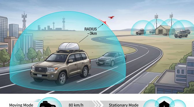
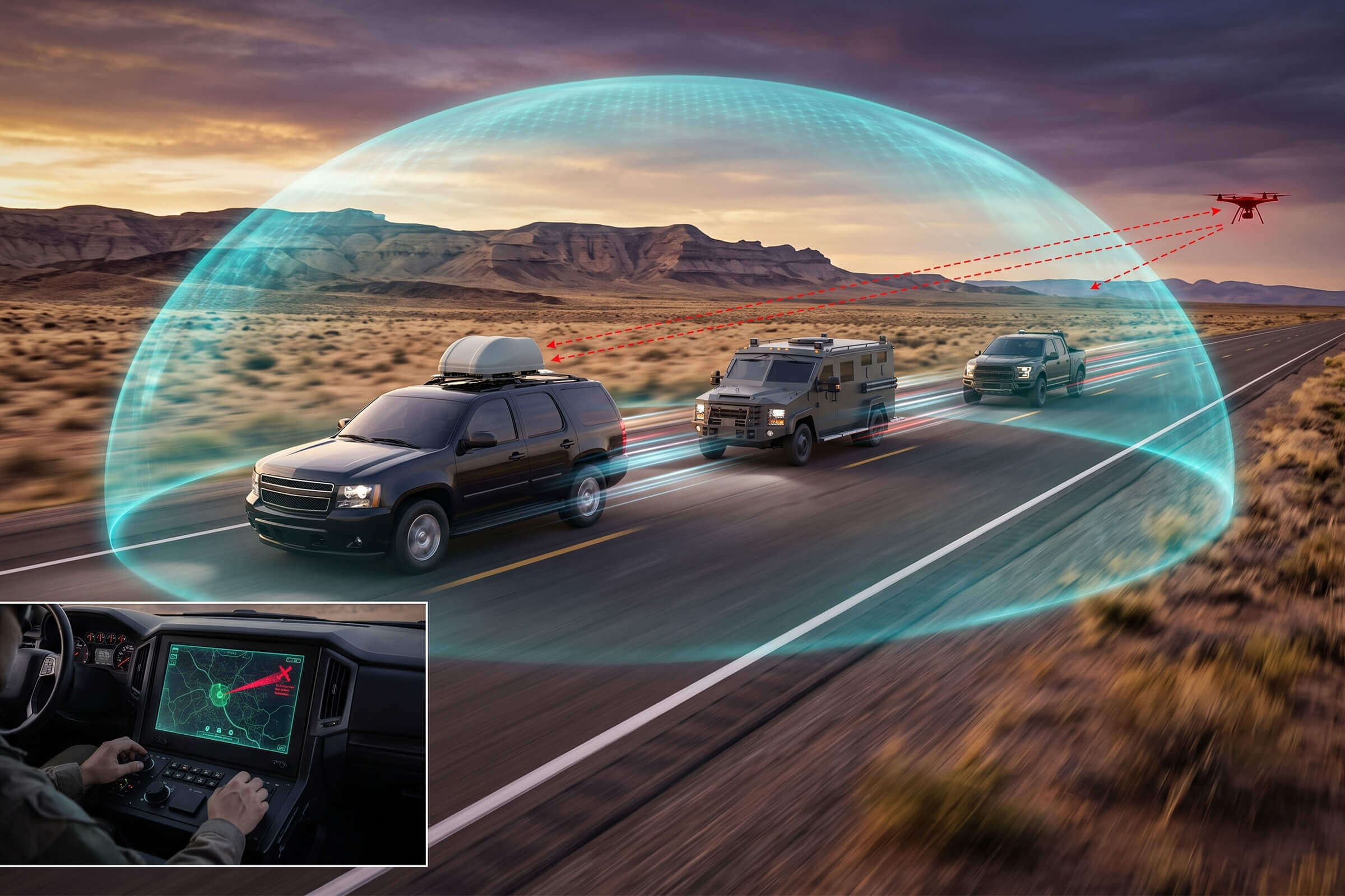
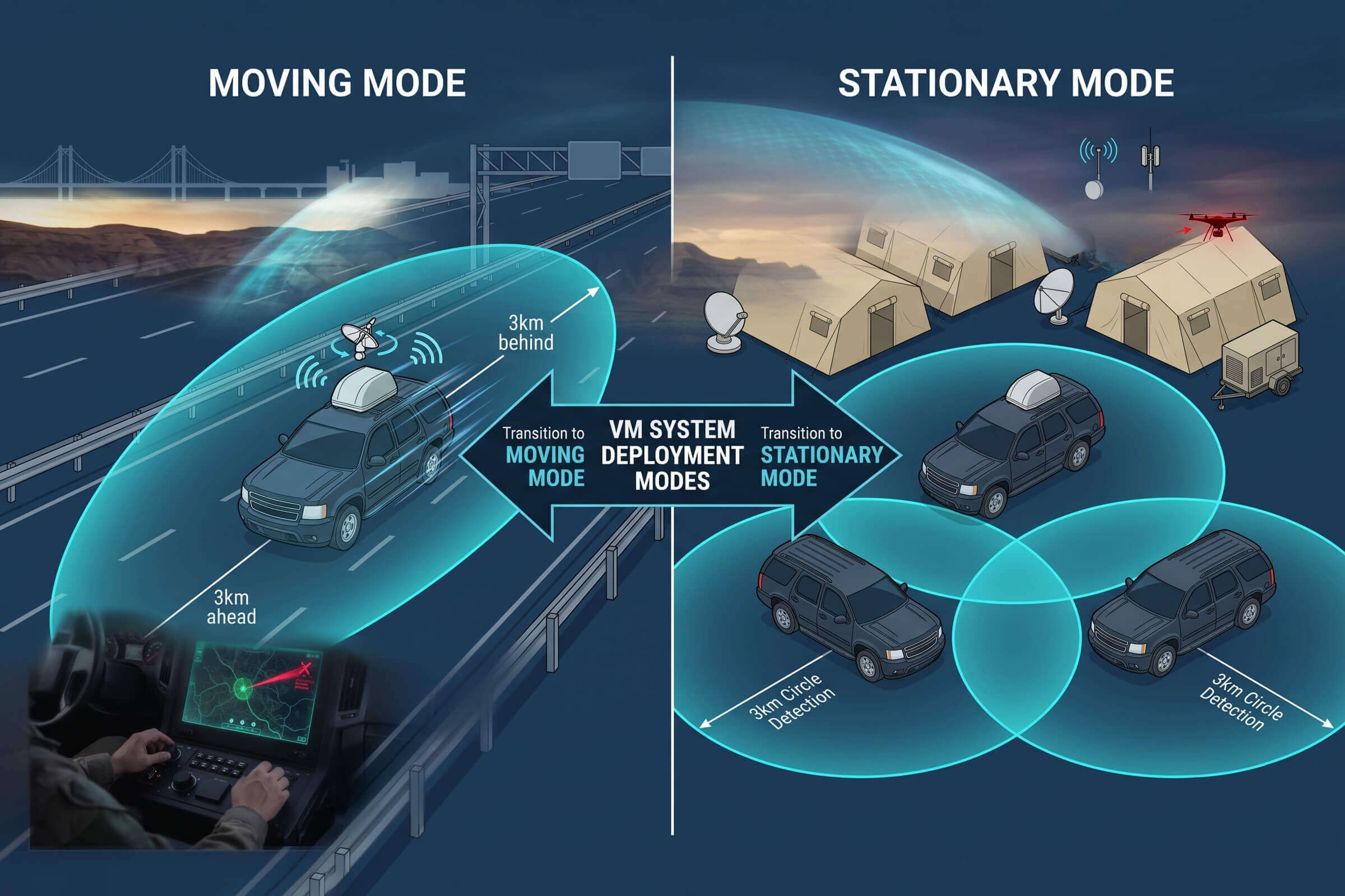
Vehicle-mounted drone defense solves this by putting detection and jamming capability on a vehicle that travels with the asset it protects. The concept is straightforward. A vehicle carries a sensor suite that scans for drone signals, identifies threats, and jams hostile drones, all while moving at highway speeds. The vehicle creates a protection bubble that moves with the convoy. When the vehicle stops, the protection bubble becomes a temporary fixed-site defense. When it moves, the bubble moves.

The physics of detecting drones from a moving vehicle

Detecting a drone from a stationary sensor is hard because of terrain, multipath, and signal attenuation. Detecting a drone from a vehicle moving at 80 kilometers per hour adds two more challenges. First, the vehicle’s own motion shifts the apparent angle of arrival of every signal it receives. The sensor is moving relative to both the drone and the remote controller, so the raw bearing data changes continuously even if the drone is stationary. Second, the vehicle itself is a noise source. Engine electronics, onboard communication systems, and the metal vehicle body all contribute to the electromagnetic environment the sensor must operate within.

The VM system addresses the motion challenge with signal processing that compensates for the vehicle’s movement in real time. It achieves direction-finding accuracy of 3 degrees RMS for a hovering target and 10 degrees RMS for a moving target, even while the vehicle is in motion. For comparison, these are the same accuracy specifications as LZ TECH’s fixed-site DF Series sensors. The vehicle’s speed, measured by its own GPS and inertial sensors, is subtracted from the incoming bearing data so the angle-of-arrival calculation reflects the drone’s true position rather than the sensor’s movement.

The detection band spans 30 MHz to 6 GHz, covering the same full range as the fixed-site systems. Detection range extends to 3 kilometers from the vehicle’s position. A drone approaching the convoy from 3 kilometers away is detected while the vehicle still has approximately two minutes of driving time before the drone closes the distance, assuming the drone is moving at 20 meters per second and the vehicle is traveling at 80 kilometers per hour.

Creating a moving protection bubble

The protection bubble concept describes an area around the vehicle where the VM system detects, identifies, and can jam drones. The size of the bubble varies with speed, terrain, and the type of drone being detected. In open terrain at moderate speed, the detection bubble extends to roughly 3 kilometers. The jamming bubble is smaller, covering the immediate airspace above and around the protected asset. The vehicle’s motion extends the bubble in real time, so a convoy of vehicles with multiple VM systems creates overlapping bubbles that cover the entire convoy length.

The jamming capability is configured for the specific operational environment. The VM system outputs across eight bands: 400 MHz, 800 MHz, 900 MHz, 1.2 GHz, 1.4 GHz, 2.4 GHz, 5.2 GHz, and 5.8 GHz. Each band is individually configurable, so the operator can activate only the frequencies that the detected drone is using while leaving other bands clear for the convoy’s own communications. The jamming is omnidirectional from the vehicle, which means the bubble is a sphere around the vehicle rather than a directional beam. For a convoy moving through open terrain where collateral interference is not a concern, omnidirectional coverage is simpler and more reliable than directional jamming that must be constantly re-aimed as the vehicle turns and changes speed.

From convoy protection to temporary site defense

The same vehicle that protects a moving convoy becomes a fixed-site defense system the moment it parks. At a temporary command post, a disaster response staging area, or a field inspection site, the vehicle stops and the VM system continues operating. The detection bubble now covers a fixed circle around the parked vehicle. Multiple vehicles can be spaced to create overlapping coverage across a temporary site of any size.

This dual-mode capability reduces the logistics burden for organizations that need both mobile and temporary fixed-site protection. Instead of deploying a convoy protection vehicle for the drive and a separate fixed-site system for the destination, the same VM-equipped vehicle covers both phases of the operation. The system transitions from mobile to stationary operation with no reconfiguration. The detection algorithms adjust automatically when the vehicle’s GPS reports zero speed.

The VM system’s environmental specifications support this dual-use profile. It is rated IP66 for protection against dust and high-pressure water jets. The operating temperature range spans -40 to +60 degrees Celsius. These ratings are not marketing specifications. They mean the system can be deployed in desert heat, in heavy rain, and in freezing conditions, without taking the vehicle offline for weather. The same vehicle that drove through a sandstorm at 40 degrees Celsius continues to provide drone detection when it parks.

A typical convoy protection deployment

A representative deployment scenario illustrates how the pieces fit together. A three-vehicle convoy is moving from a headquarters building to a field inspection site 120 kilometers away. The lead vehicle carries a VM system with the detection and jamming suite integrated into a roof-mounted enclosure. The middle vehicle carries the protected principals. The trail vehicle provides rear security.

As the convoy departs the headquarters, the VM system begins scanning the 30 MHz to 6 GHz band. Two minutes into the drive, it detects an unknown drone signal at 2.4 GHz, approximately 2.5 kilometers ahead and slightly to the right of the convoy’s direction of travel. The detection data identifies the drone as a DJI Mavic 3, provides the drone’s GPS coordinates and altitude, and plots the remote controller position on a map. The convoy commander evaluates the information: the drone is at 120 meters altitude and its position suggests it is mapping a construction site adjacent to the highway, not tracking the convoy. The commander logs the detection and continues. The VM system records the encounter for post-mission analysis.

Twenty kilometers from the destination, a second detection appears. A smaller drone, identified as a custom FPV quadcopter, is approaching from the convoy’s left at 15 meters altitude, heading directly toward the middle vehicle. The convoy commander activates the jamming system on the 2.4 GHz and 5.8 GHz bands. The FPV drone loses its video and control link and falls to the ground 800 meters from the convoy. The convoy continues without stopping. The entire sequence, from detection to neutralization, takes under 30 seconds.

Where vehicle-mounted systems fit in the broader C-UAS field

Vehicle-mounted systems do not replace fixed-site installations. They complement them. A permanent facility that needs 24-hour protection is better served by a fixed grid of DF Series sensors, D5-B TDOA nodes, and electro-optical verification systems. A convoy, a temporary site, or a mobile inspection team that has no fixed address needs a system that moves. The VM fills that gap. Its specifications parallel the fixed-site product line in detection range, frequency coverage, and accuracy. The difference is the form factor and the motion compensation that makes mobile operation possible.

For organizations that operate across distributed sites connected by road, the combination of fixed-site protection at each facility and vehicle-mounted protection for the road segments between them closes the coverage gap. The drone threat does not respect the property line between the perimeter fence and the highway. A vehicle-mounted system ensures the protection extends to wherever the asset goes, not just to wherever the asset parks.

Standalone Systems vs. OEM Modules: An Integrator’s Guide to Drone Defense

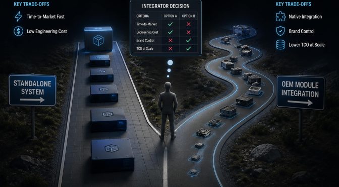
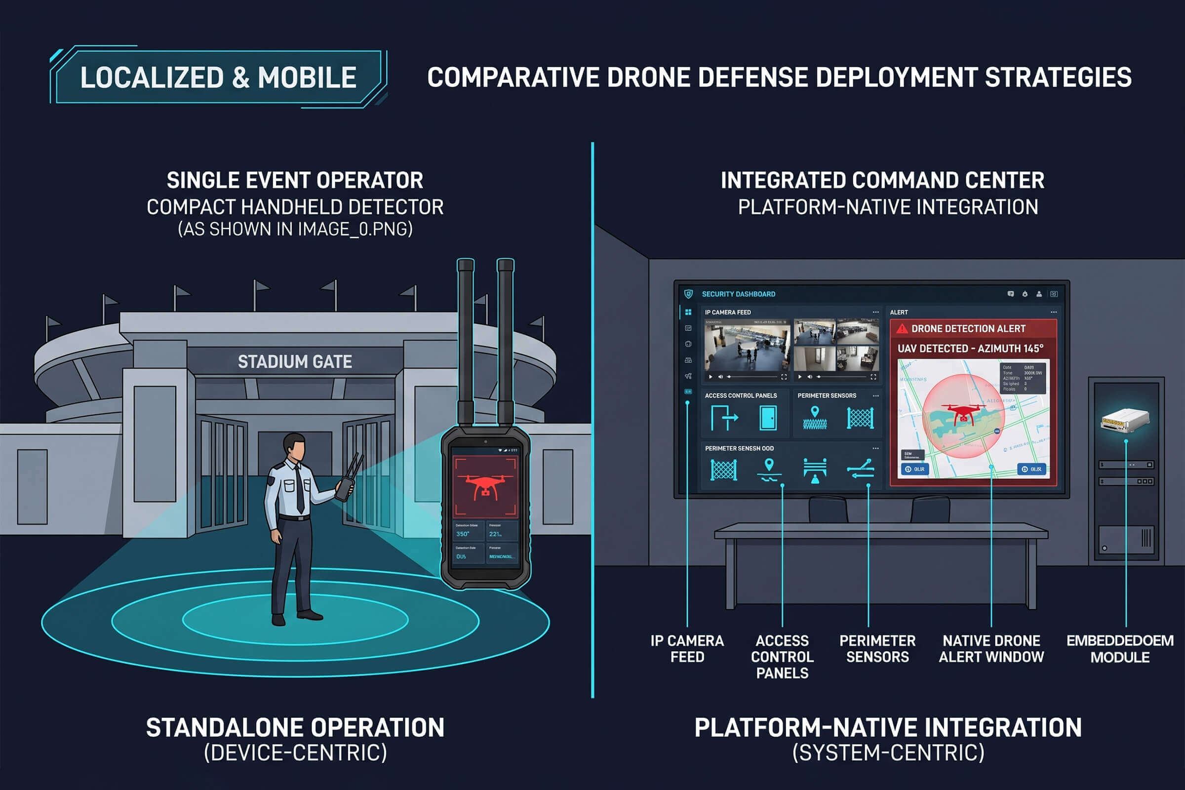
A system integrator adding drone defense to a security platform faces a real fork in the road. One path is to pick a ready-made piece of hardware, plug it in, and hand the end user the controls. The other is to pull the detection engine out of that hardware, embed it inside the integrator’s own platform, and present a unified experience under a single brand. Both paths lead to a working solution. The difference is in who owns the integration, who owns the brand, and what the total cost looks like after the tenth deployment.

This article walks through both paths with concrete product examples. For the standalone path, three LZ TECH systems serve as reference points: the HJ1 handheld unit for portable security, the J3 fixed-site system for permanent installations, and the JV-1 for sites that face a high proportion of FPV and custom-built drones. For the OEM path, the D-MB Mini detection module and its larger siblings in the OEM module family show what embedded integration looks like.

Path A: Pick a product and go

The standalone approach is the simpler starting point. A self-contained drone defense device arrives in a flight case, mounts on a pole or sits in a vehicle, connects to power and network, and begins operating. The integrator does not write code. The end user gets a separate interface for drone defense alongside their existing security platform. Implementation takes days, not months.

Three LZ TECH systems illustrate the range of what a standalone product can look like.

HJ1: Handheld, portable, single-operator

The HJ1 is a handheld drone defense system designed for one person to carry and operate. It weighs 6.5 kilograms with its battery installed, and its built-in handle and strap ports make it practical for a security officer to carry on patrol or deploy at a checkpoint. The device covers six frequency channels spanning the bands most commonly used by commercial drone communication and navigation links, from 800 MHz through 5.8 GHz. Its high-gain directional antenna array focuses its output on the target drone rather than broadcasting across the entire area, which matters when operating near other RF-dependent equipment. Response time from trigger to full output is under five seconds, measured as an RMS value across operational conditions.

The HJ1 is battery-powered with a field-replaceable lithium-ion pack, giving roughly half an hour of continuous operation on a single charge. It charges from zero to full in under two hours. The IP54 rating means it handles dust and splashing water, and it operates from minus 25 to 55 degrees Celsius. For deployments that need detection before action, the HJ1 includes an expansion holder and interface for an external handheld detection module, which adds drone identification and alarm capabilities to the jammer-only baseline.

For an integrator serving event security, VIP protection details, or rural patrol teams, the HJ1 is the kind of device that a single operator can deploy from a vehicle without tools. The integration story is simple: hand the device to the security team, provide basic training, and the capability is live.

J3: Fixed-site, 360-degree, always on

The J3 is a stationary drone defense system built for permanent installation. It uses eight independent channels to cover the full range of frequencies used by commercial drones for video transmission, remote control, and navigation, from 430 MHz through 5.8 GHz. The omnidirectional antenna array covers 360 degrees horizontally and plus or minus 90 degrees vertically. There are no blind spots.

The J3 supports precise selective targeting when paired with an external detection system. It can address a specific threat drone in an airspace that also contains friendly or authorized drones, rather than affecting everything in the sky. It also supports network integration with radar, electro-optical, and RF detection equipment, enabling an unattended detect-and-respond workflow. Response time is under five seconds.

Environmental resilience is one of J3’s stronger design points. IP66 protection keeps out dust and high-pressure water jets. The operating temperature range spans minus 40 to 55 degrees Celsius. It runs on AC power with low standby draw, and the flight-case packaging makes transport and installation straightforward for a fixed-site deployment team. At roughly 35 kilograms for the device itself, the J3 is not portable in a patrol-bag sense. It is meant to be mounted, connected, and left to run.

For an integrator serving airports, correctional facilities, or government buildings, the J3 is the permanent-installation option. Mount it, network it, and it becomes part of the facility’s infrastructure.

JV-1: Purpose-built for FPV and custom drones

The JV-1 addresses a specific problem that generic drone defense systems can miss. FPV racing drones and custom DIY builds often operate on frequency bands outside the standard commercial drone channels. The JV-1 targets these non-standard links specifically: the TBS Crossfire and ExpressLRS protocols at 868 and 915 MHz, analog FPV video feeds at 1.2 GHz, and the wider 5.1 to 5.9 GHz range used by high-power digital video systems. It uses a combination of narrowband and frequency-hopping techniques to match the agile signaling that FPV drones employ.

The JV-1 has a unique capability that is worth noting for integrators who work with security teams that need visual confirmation. When connected to a radio detection system, the JV-1 can display the drone’s first-person camera feed directly in the operator’s software interface. The security officer sees what the drone pilot sees. It can also transmit custom text or image alerts to FPV goggles and video receivers in the area, which has operational utility for communicating with an unknown drone operator.

The JV-1 is a fixed-site device with 360-degree omnidirectional coverage, IP66 protection, and an operating range from minus 40 to 60 degrees Celsius. It weighs under 25 kilograms without its antennas and ships in flight cases. It supports fixed, vehicle-mounted, and mobile deployment configurations. For an integrator whose customer base includes prisons or critical infrastructure sites that have reported FPV drone incursions, the JV-1 is the specialized tool for a specialized threat.

Path B: Embed the detection engine

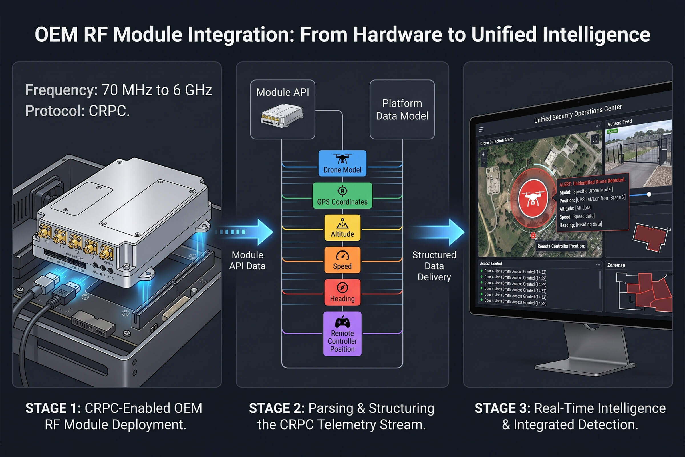
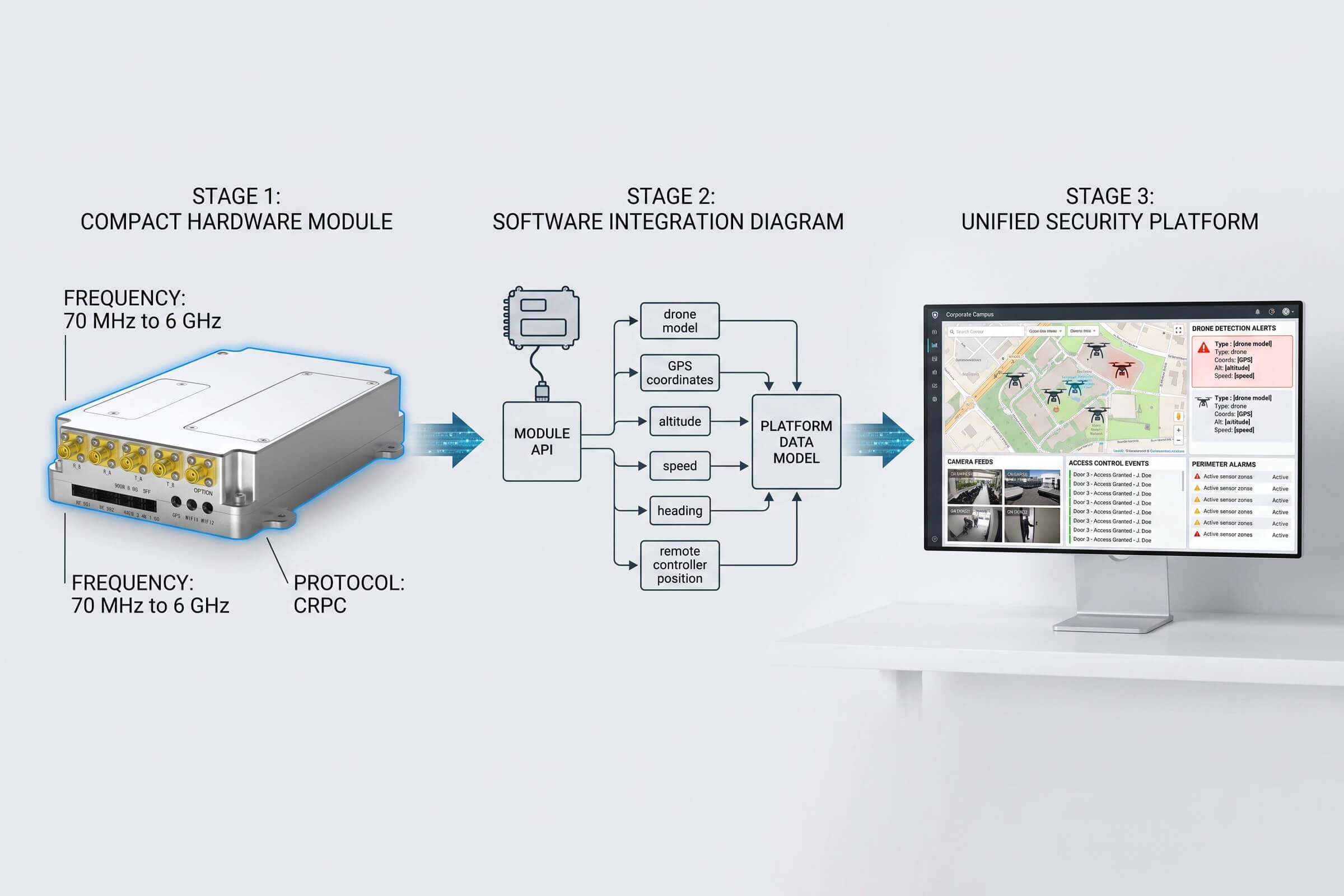
The OEM module path takes a different approach. Instead of buying a complete product, the integrator buys a compact hardware unit that contains an RF front end and an onboard processor running the detection software. The module detects drones, identifies the model and protocol, and outputs structured data through an API. It does not include a case, an antenna array, a user interface, or a dashboard. It provides a data feed and leaves everything else to the integrator’s platform.

LZ TECH’s OEM module family follows this model. The modules cover 70 MHz to 6 GHz, using the CRPC protocol analysis engine to decode drone communication and identification protocols. The structured data output from the module includes the detected drone model, its serial number or identification marker, GPS coordinates, altitude, speed, heading, and the position of the remote controller. The integrator’s software ingests this stream through the API and renders it in whatever form the platform’s interface requires.

The D-MB Mini is the compact entry point in this family. It is designed for space-constrained platforms: portable security devices, compact sensor nodes, and handheld equipment where the module must fit inside an existing chassis. Larger module variants add direction-finding capability for platforms that need bearing data alongside detection, and higher sensitivity for fixed-site installations that require the longest possible detection range. All variants run the same CRPC detection core, so an integrator who qualifies one module can add new deployment profiles by selecting a different module variant rather than starting a new integration project.

The integration investment is front-loaded. The integrator’s development team builds the user interface components, the alerting pipeline, and the data mapping from the module’s API output into the platform’s internal data model. Once complete, adding drone detection to additional deployments is a configuration change, not a hardware procurement. The CRT display, the alert rules, the operator workflow, and the audit trail are all native to the integrator’s platform. It is delivery of a native capability rather than the bolt-on of a third-party product.

How the two paths fit together in practice

A representative deployment shows why the choice between standalone and OEM is not either-or for many integrators. Consider a security company that operates a command-and-control software platform for correctional facilities. They have twenty prison sites under contract. At each site, they need drone detection and defense. They also sell their platform to new customers who have no existing drone security infrastructure.

For the core detection capability that rolls out to all twenty sites and every new customer, the OEM module path makes sense. Embed the detection engine once, spread the integration cost across all deployments, and present a unified interface to every customer. The integrator owns the capability. For the defense hardware at each site, they might deploy a J3 mounted on a watchtower, connected to the platform through the network integration interface. The platform receives detection data from the embedded OEM module, correlates it with the J3’s status, and presents a single workflow to the operator. The detection is native to the platform. The defense layer is a best-in-class standalone system that the platform manages as a networked device.

At a site that reports FPV drone intrusions, they add a JV-1 alongside the J3. The threat profile determines the defense hardware. The integration depth determines the operator experience. Both can be chosen independently.

The decision framework

Five questions cut through the standalone-versus-OEM trade-off. They are the same questions regardless of which specific products the integrator evaluates.

Question one: What is the deployment timeline? A single site going live next month points toward a standalone device like the HJ1 or J3. A platform capability shipping to a growing customer base over years points toward OEM module integration.

Question two: What is the expected deployment volume? Below roughly five to ten sites, the standalone product often wins on total cost because the integration investment has not yet amortized. Above that, the OEM module becomes the lower total cost. The crossover point depends on the integrator’s internal engineering costs, but the logic is the same.

Question three: How tight does the integration need to be? If drone defense alerts must appear on the same map as camera feeds, access control events, and perimeter alarms, the OEM module delivers native integration. A standalone product will always require the operator to look at a separate interface or a separate pane within the platform that was bolted on rather than built in.

Question four: Who owns the end customer? If the integrator’s value proposition depends on single-vendor accountability and consistent brand experience across all security domains, embedding OEM modules keeps everything behind the integrator’s brand. The standalone path puts a visible third-party label on the drone defense capability.

Question five: What is the long-term supplier flexibility requirement? If the integrator needs the ability to swap detection or defense hardware suppliers with minimal end-customer disruption, the OEM module architecture provides that flexibility through a defined API layer. The standalone approach creates a tighter coupling to a specific product’s lifecycle and roadmap.

The products are real. The choice depends on you

The HJ1, J3, JV-1, and the D-MB Mini are not concept designs. They are products with shipping histories, compliance certifications, and field hours. The HJ1 has been carried by security teams at outdoor events and sensitive facilities. The J3 is mounted on rooftops and perimeter walls. The JV-1 addresses a threat category that generic systems miss. The D-MB Mini runs inside partner platforms that bear other companies’ brand names.

The integrator’s job is to match the product to the deployment profile. The handheld for the roving patrol. The fixed site for the permanent perimeter. The FPV specialist for the facility that sees custom drones. The OEM module for the platform that ships to dozens of sites under a single brand. There is no single correct answer across all scenarios. There is a correct answer for each scenario. The framework is the tool for finding it.

Stadium Drone Security: Detection, Identification, and Mitigation for Major Sporting Events

Every summer, the global sporting calendar puts tens of thousands of people in outdoor stadiums. The Olympic Games, the Premier League, the MLB season, the UEFA European tournaments. For security directors at these venues, the checklist is long. Crowd management, access control, perimeter monitoring. One item that used to be near the bottom has been moving up the list fast: drone incursions.

The numbers tell the story. Between 2019 and the end of 2025, the UK AirproX Board recorded over 600 drone-related incidents across the country, many involving large public gatherings. France’s civil aviation authority reported at least 60 confirmed drone sightings over prohibited French airspace during the 2024 Olympic Games period alone. These are not hypothetical scenarios. They are data points from events that already happened.

A drone over a stadium creates three problems at once. First, there is the physical safety risk. An out-of-control drone falling into a crowd is a kinetic event. Second, there is the operational disruption. A confirmed drone sighting during a match forces organizers to decide within seconds whether to pause the event, evacuate sections, or continue and hope. Third, there is the reputational damage. Video of a drone hovering over a packed stadium goes viral before security has even identified the operator. A stadium that cannot secure its airspace is a stadium that loses public trust.

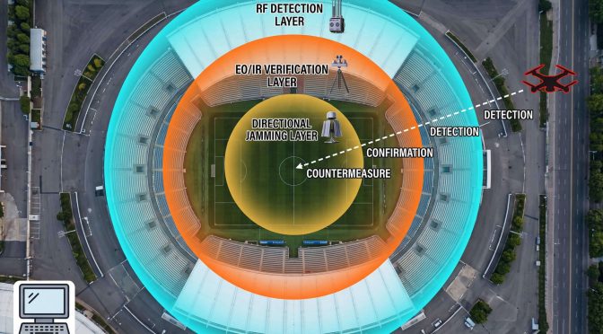
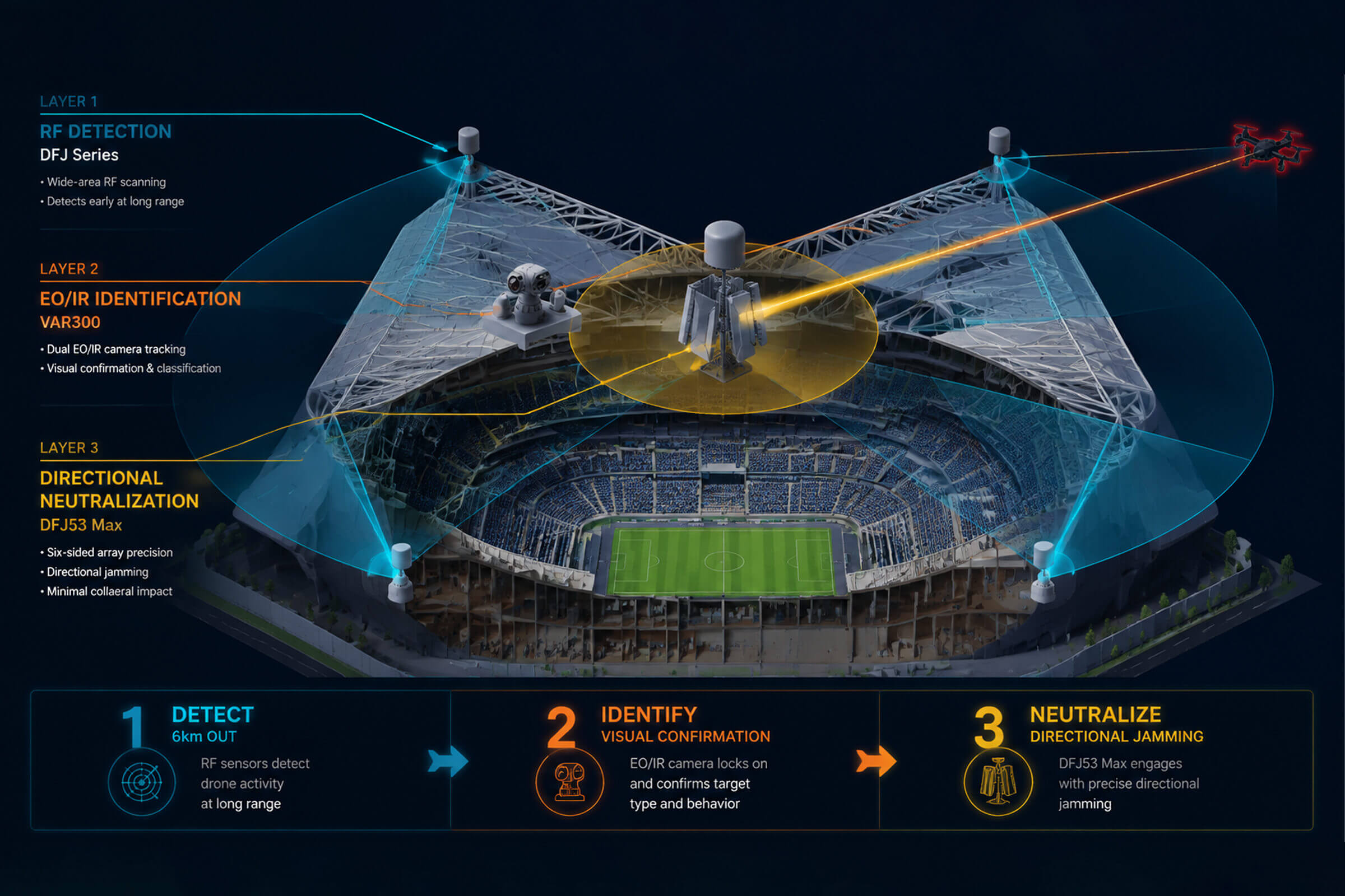
This article walks through a layered approach to stadium drone security: passive detection to find the drone, electro-optical verification to confirm the threat, and directional jamming to neutralize it. The goal is protection without disruption. A full stadium should not have to be empty because one person flew a drone too close.

The stadium detection challenge

Stadiums are among the hardest environments for drone detection. The same characteristics that make a stadium a good venue make it a difficult RF environment. Metal roof structures reflect signals. Tens of thousands of mobile phones create background noise across multiple frequency bands. Broadcast equipment, Wi-Fi networks for press and operations, and public safety radio systems crowd the spectrum. A detection system that works in an open field may struggle in a stadium with a full crowd on game day.

Passive RF detection is the first layer because it addresses the core challenge without adding to it. The DFJ Series is an all-in-one detection and jamming system designed for fixed-site deployment. For stadium use, the DFJ83 model begins with detection across 30 MHz to 6 GHz, covering the frequency bands used by almost all commercial and consumer drones. It identifies the drone model, serial number, GPS coordinates of both the drone and its remote controller, altitude, speed, and heading. All of this happens without the sensor emitting a signal. The drone and its operator have no way of knowing they have been detected.

The DFJ83 achieves direction-finding accuracy of 3 degrees for a hovering drone and 10 degrees for a moving target. In a stadium setting, where seconds matter, that bearing tells the security team roughly where in the sky to look and roughly where the operator is standing. The detection range extends to 8 kilometers. In practice, this means a drone approaching a stadium can be picked up while it is still kilometers away, giving the team several minutes of decision time before it enters the exclusion zone.

For stadium deployments that require 360-degree coverage with zero gaps, the DFJ53 Max is the higher-specification option. Its six-sided high-gain shield array uses adaptive beamforming to create a full-circle defensive perimeter. Detection spans 400 MHz to 6 GHz with a range of up to 5 kilometers. The system detects mainstream UAVs, FPV racing drones, and custom DIY builds. It operates autonomously 24 hours a day, 7 days a week, and integrates its detection and mitigation functions into a single closed loop: identify, track, neutralize. The zero-blind-spot design matters at a stadium where a drone could approach from any direction, and a gap in coverage means a gap in security.

Seeing what RF detects: the VAR300 verification layer

RF detection tells the security team that a drone is out there and gives a bearing and approximate position. For a stadium where the response protocol requires escalation before any disruption to the event, that approximate fix is not enough. The team needs visual confirmation before they act. They need to know the drone is real, what it looks like, and whether it is moving toward the venue or just passing nearby.

The VAR300 is a fixed electro-optical and infrared surveillance system that provides that confirmation. Once an RF sensor hands off a target bearing, the VAR300 slews its dual thermal and visible-light cameras toward the bearing and begins autonomous tracking. In daylight, it detects a DJI Mavic 3 at 1 kilometer or more and maintains tracking beyond 1.5 kilometers. At night, its VOx uncooled infrared detector with 640 by 512 resolution detects the same target at 500 meters and tracks it at 800 meters. The built-in AI recognition engine classifies objects and suppresses false alarms from birds, aircraft, and other moving objects in the sky.

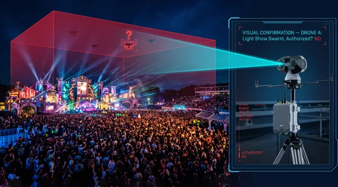
For a stadium security director, the VAR300 solves a specific problem. The clock starts ticking the moment an RF detection alert appears. Without visual confirmation, the only safe option is to treat every alert as a real threat. That leads to unnecessary event pauses and crowd disruption. With visual confirmation from the VAR300, the team can distinguish a real drone incursion from a false alarm in seconds rather than minutes. The camera’s screen shows the captured image, the target similarity score from the AI classifier, and the real-time bearing. The decision to escalate becomes an informed one rather than a reflexive one.

Airborne coverage for stadium blind spots

A stadium’s physical structure creates detection blind spots that ground-based sensors alone cannot resolve. The underside of a roof overhang. The approach corridor is blocked by a neighboring high-rise. The sector is masked by the stadium’s own lighting towers. A drone that comes in low along one of these shadow zones can pass under the beam of every fixed ground sensor on the property.

The D5-Air is an airborne RF detection payload that mounts on a standard commercial UAV platform such as the DJI M400 or M350. From its airborne position, it scans 400 MHz to 6 GHz and achieves a detection range of up to 5 kilometers. It feeds received signal data in real time back to the ground station, where it integrates with the DFJ Series and VAR300 data streams through the CCS command platform. The D5-Air spends its flight time above the stadium periphery, looking down into the zones that ground sensors overlook. When the event ends, it lands. During the event, it fills the gap.

From detection to response: the jamming decision

Not every drone detection requires a jamming response. Some drones are simply passing overhead at altitude with no relation to the event. Some are operated by the media with accreditation. But when a drone is identified as a genuine threat, the response needs to be fast, precise, and contained. A stadium packed with 60,000 people cannot tolerate broadband interference that disrupts mobile phone service, broadcast equipment, or emergency communications.

Directional jamming is the solution to that constraint. The DFJ83 jams drones across bands at 900 MHz, 1.5 GHz, 2.4 GHz, 5.2 GHz, and 5.8 GHz, with each band configurable independently. Its effective jamming range extends to 3 kilometers. The jamming is directional rather than omnidirectional. It targets the specific bearing where the drone and its operator are located. The rest of the stadium, including mobile networks, Wi-Fi, and broadcast frequencies, remains unaffected.

The DFJ53 Max takes directional precision further. Its six-sided high-gain shield array with adaptive beamforming produces 360-degree high-power directional jamming that focuses energy on the threat axis. The beamforming technology steers the jamming signal electronically rather than mechanically, so there are no moving parts to maintain and no lag time while an antenna rotates. The system suppresses the drone’s image transmission, data link, and navigation link simultaneously. The affected area is a narrow cone centered on the drone, not a wide circle around the stadium.

An integrated workflow: from seconds to resolution

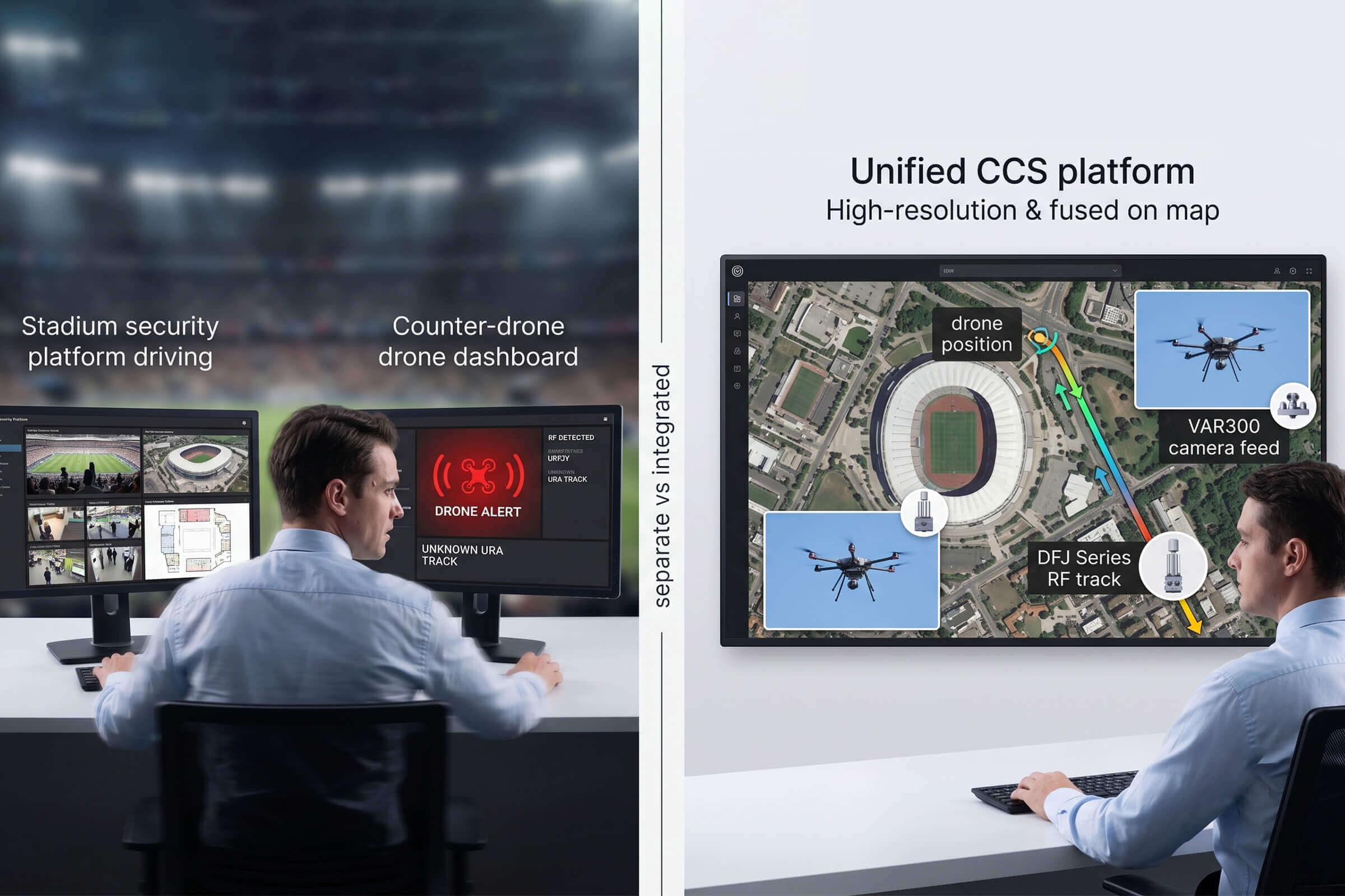
The pieces fit together in a sequence that, when rehearsed, takes the security team from detection to resolution with clarity at each step. A drone enters the detection perimeter at 6 kilometers, picked up by a DFJ83 or DFJ53 Max node positioned on the stadium roof. The CCS platform receives the alert and presents the drone’s model, position, altitude, speed, and operator location on a single map. The VAR300 camera slews to the assigned bearing and begins visual tracking. The security director confirms the threat visually on the VAR300 feed. If the drone continues toward the exclusion zone, the jamming system is activated on the specific bearing. The drone loses its control and video link and either returns to its home point or descends immediately. The event continues uninterrupted.

This workflow does not depend on any single product working perfectly. The RF detection system provides range and identification. The electro-optical system provides visual confirmation and AI classification. The airborne sensor covers the blind spots. The directional jamming system provides precision neutralization that respects the electromagnetic environment of a packed stadium. Each layer handles what it handles best. The platform ties them together.

For stadium operators planning their airspace security for the 2026-2027 season, the technology exists. The implementation is a matter of site survey, sensor placement, and integration testing. The season calendar does not wait.

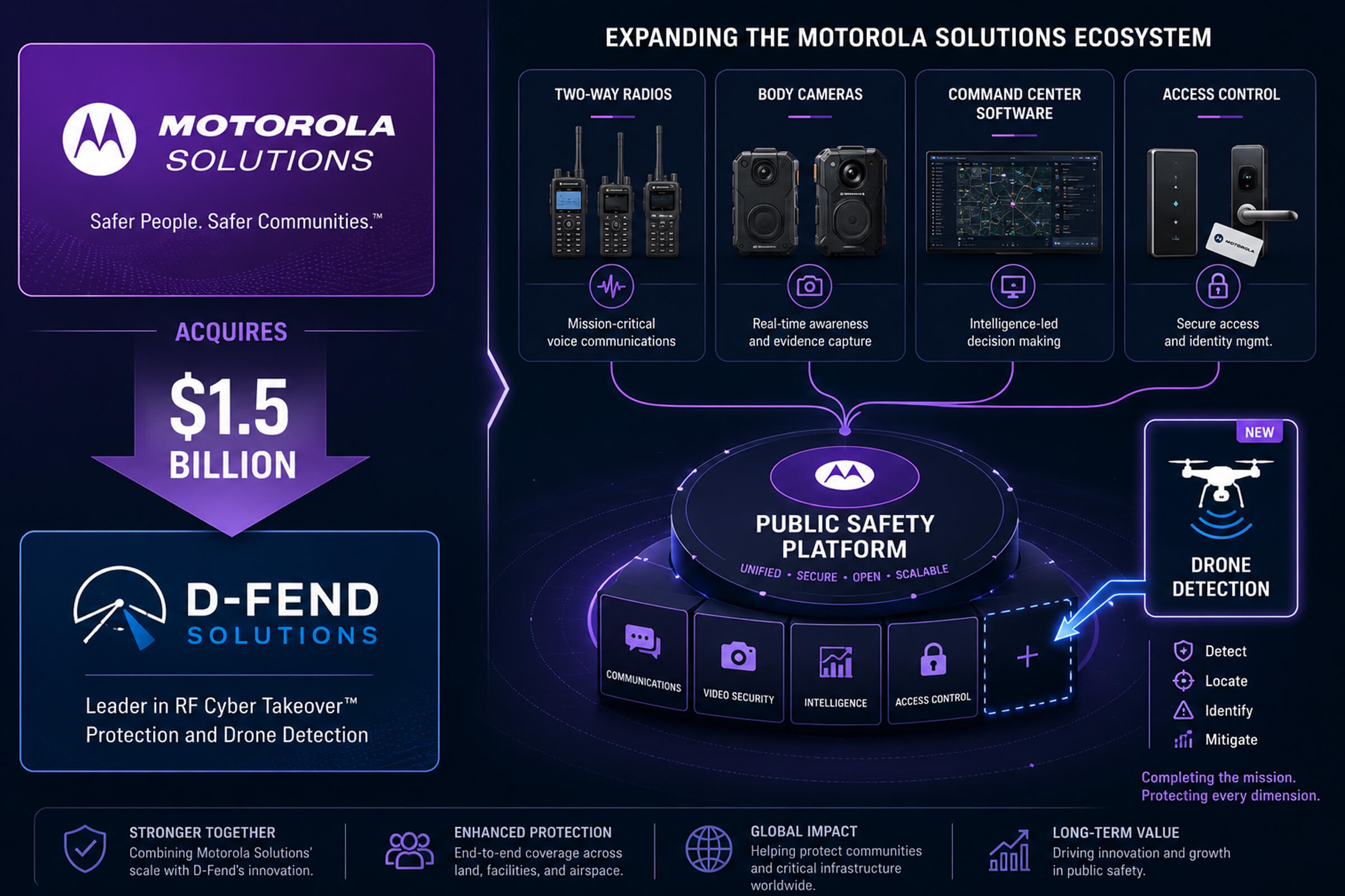
Motorola Acquires D-Fend for $1.5 Billion: What Platform Giants Entering Counter-Drone Means for System Integrators

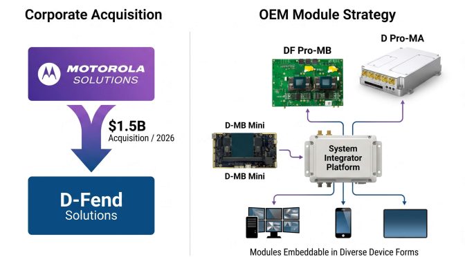
In June 2026, Motorola Solutions announced the acquisition of D-Fend Solutions, an Israeli counter-drone technology company, for approximately 1.5 billion dollars. The deal closed within weeks, and by July, Motorola had already begun integrating D-Fend’s EnforceAir radio-frequency takeover technology into its broader public safety and security portfolio.

This acquisition matters for reasons that go beyond the dollar amount, which is large. It matters because of who the buyer is. Motorola Solutions is not a defense contractor. It is a communications and public safety technology company. Its core customers are police departments, emergency services, airports, stadiums, and municipal governments. The same organizations that are increasingly being asked to respond to drone incidents. Motorola’s entry into counter-drone is a signal that the market has shifted from a niche security concern to a mainstream public safety requirement.

The platform effect: what happens when a communications giant enters C-UAS

Motorola’s existing customer relationships span tens of thousands of public safety agencies worldwide. Its product ecosystem includes two-way radios, body-worn cameras, video management systems, command center software, and access control. Adding drone detection and mitigation to that portfolio is not a diversification play. It is an adjacency play. The same police department that buys Motorola radios for its patrol officers is the department that gets called when a drone drops contraband into a prison yard or flies over a stadium during a game. Motorola can now sell that department a counter-drone solution through the same procurement channel and the same sales team that already serves the account.

For D-Fend, the acquisition solves a distribution problem. D-Fend’s technology, particularly its RF-based cyber takeover approach that avoids jamming and instead seizes control of the drone’s communication link, is technically differentiated. But D-Fend was a mid-sized company selling to government security agencies one deal at a time. Motorola turns that sales motion into a portfolio sale. The counter-drone capability becomes a checkbox on a broader public safety proposal rather than a standalone procurement that requires a separate vendor evaluation.

For the counter-drone industry as a whole, the Motorola-D-Fend deal is one of several signals suggesting that large platform companies see C-UAS as a growth adjacency. When a company with Motorola’s market access and installed base enters a category, it changes the competitive dynamics. Smaller pure-play C-UAS companies face a new kind of competitor: one that can bundle drone detection with radios, cameras, and command center software in a single contract, and that already has the customer relationship before the counter-drone conversation even starts.

The integrator’s dilemma: buy a complete system or build with modules

For system integrators and security technology providers that are not Motorola, the acquisition raises a strategic question. If platform companies are entering the counter-drone market with complete, vertically integrated solutions, what is the path for an integrator that wants to add drone detection to its own product lineup without becoming a reseller for a competitor?

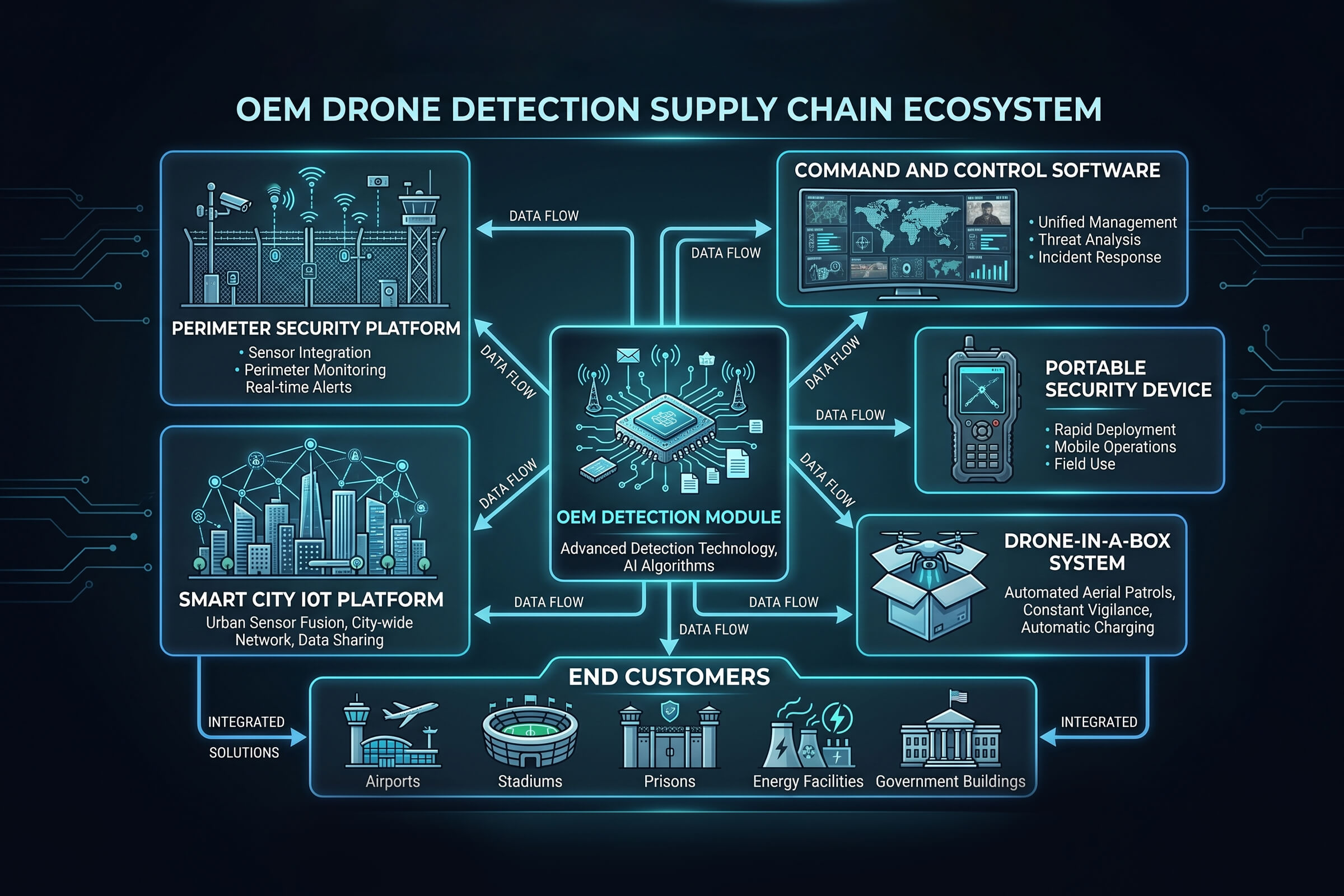
The answer, for a growing number of integrators, is OEM detection modules. Rather than buying a complete counter-drone system with its own command interface, user management, and reporting tools, an integrator purchases a detection engine as an embeddable component. The integrator integrates that component into its own platform, behind its own user interface, under its own brand. The end customer sees a unified security system, not a separate counter-drone add-on with a different login and a different support contract.

LZ TECH’s OEM detection module family is designed for exactly this use case. The modules are compact hardware units that combine an RF front end covering 70 MHz to 6 GHz with an onboard computing unit running LZ TECH’s protocol analysis software. They include a full API interface for integration into third-party command and control platforms. They detect and identify drone models from DJI, Autel, and other major manufacturers, as well as DIY and FPV drones that use non-standard protocols.

The OEM module family currently includes the D-MB Mini, the DF Pro-MB, and the D Pro-MA, covering different size, power, and performance requirements. All three share the same CRPC-based detection engine. The differences are in form factor, antenna configuration, and deployment profile. The D-MB Mini is designed for embedded integration in space-constrained platforms such as portable security devices and compact sensor nodes. The DF Pro-MB adds direction-finding capability for applications that need bearing information in addition to detection and identification. The D Pro-MA offers the highest sensitivity for long-range detection in fixed-site deployments.

The integrator provides the enclosure, the mounting, the power supply, the networking, the user interface, and the response workflow. LZ TECH provides the detection intelligence. This division of labor lets the integrator build counter-drone capability into its existing product line without developing RF expertise from scratch, while maintaining full control over the customer relationship and the user experience.

What the Motorola deal signals for the module market

When a platform company acquires a counter-drone vendor, it creates two effects for the module market. First, it validates the technology category. A 1.5 billion dollar acquisition price says that counter-drone RF technology has substantial enterprise value and a credible growth trajectory. That attracts investment and customer attention to the broader category, including module-based approaches.

Second, it creates a competitive gap that modules fill. Motorola’s integrated solution will appeal to organizations that already use Motorola products and want a single-vendor stack. But it will not appeal to integrators who compete with Motorola in adjacent categories, or to organizations that have standardized on a different security platform and do not want to introduce a second vendor’s command interface. For those buyers, an OEM module that integrates into their existing platform is the natural choice. The Motorola acquisition does not shrink the module market. It expands it, by making counter-drone capability a must-have rather than a nice-to-have for any security platform that serves critical infrastructure or public safety customers.

LZ TECH’s position in this market is built on two advantages. The first is protocol coverage. The CRPC engine, now in its third generation, decodes drone communication protocols at the application layer and, in its most advanced form, the control layer. This produces the drone model, serial number, GPS coordinates, altitude, speed, and remote controller position — not merely a detection alert. For an integrator embedding a detection module, the richness of the data feed determines how much value the integrator can build on top of it. A module that only says ‘drone detected at 2.4 GHz’ gives the integrator very little to work with. A module that says ‘DJI Mavic 3, serial number X, at coordinates Y, altitude Z meters, flying toward bearing W, pilot at coordinates P’ gives the integrator everything they need to build a complete situational awareness display and response workflow.

The second advantage is scale. LZ TECH has shipped to customers in more than 60 countries and maintains a 10,000-square-meter manufacturing and service center in Luoyang, China, with approximately 500 employees, roughly 40 percent of whom are in research and development. For an integrator selecting an OEM module partner, the question is not only whether the module works today. It is whether the supplier will be updating the drone protocol database, adding support for new models, and shipping product five years from now. Scale and R&D depth matter for that answer.

A market that is just getting started

The Motorola-D-Fend deal is unlikely to be the last acquisition of its kind. As counter-drone technology moves from specialized military procurement to mainstream public safety and critical infrastructure spending, more platform companies will look for entry points. Some will acquire. Some will partner. Some will build in-house. For system integrators that want to offer counter-drone capability without waiting for the next acquisition cycle or building RF expertise from the ground up, OEM detection modules provide a path that is available today, not in the next funding round.

The counter-drone market is accelerating. Platform companies entering the space is both a symptom of that acceleration and a cause of further acceleration. The integrators that move now, while the supply chain of embeddable detection modules is mature and the competitive field is still taking shape, will be the ones whose platforms are ready when the request for proposal arrives with a counter-drone requirement on page three.

How RF Direction Finding Works: From Angle-of-Arrival to Networked TDOA Positioning

If you set up a drone detection system that listens but never transmits, you are using radio frequency direction finding. The concept is simple in principle and subtle in practice. A drone talks to its remote controller. That conversation uses radio waves. A passive sensor tuned to the right frequency bands picks up the conversation, measures where it is coming from, and, when multiple sensors work together, triangulates the source location. The system emits nothing. It reveals nothing about itself. It just listens.

This article explains the two core techniques behind passive drone detection—angle-of-arrival and time-difference-of-arrival—and walks through the LZ TECH products that use them. No signal transmission, no jamming, no navigation interference. Just receiving.

Angle-of-arrival: which direction is the drone in?

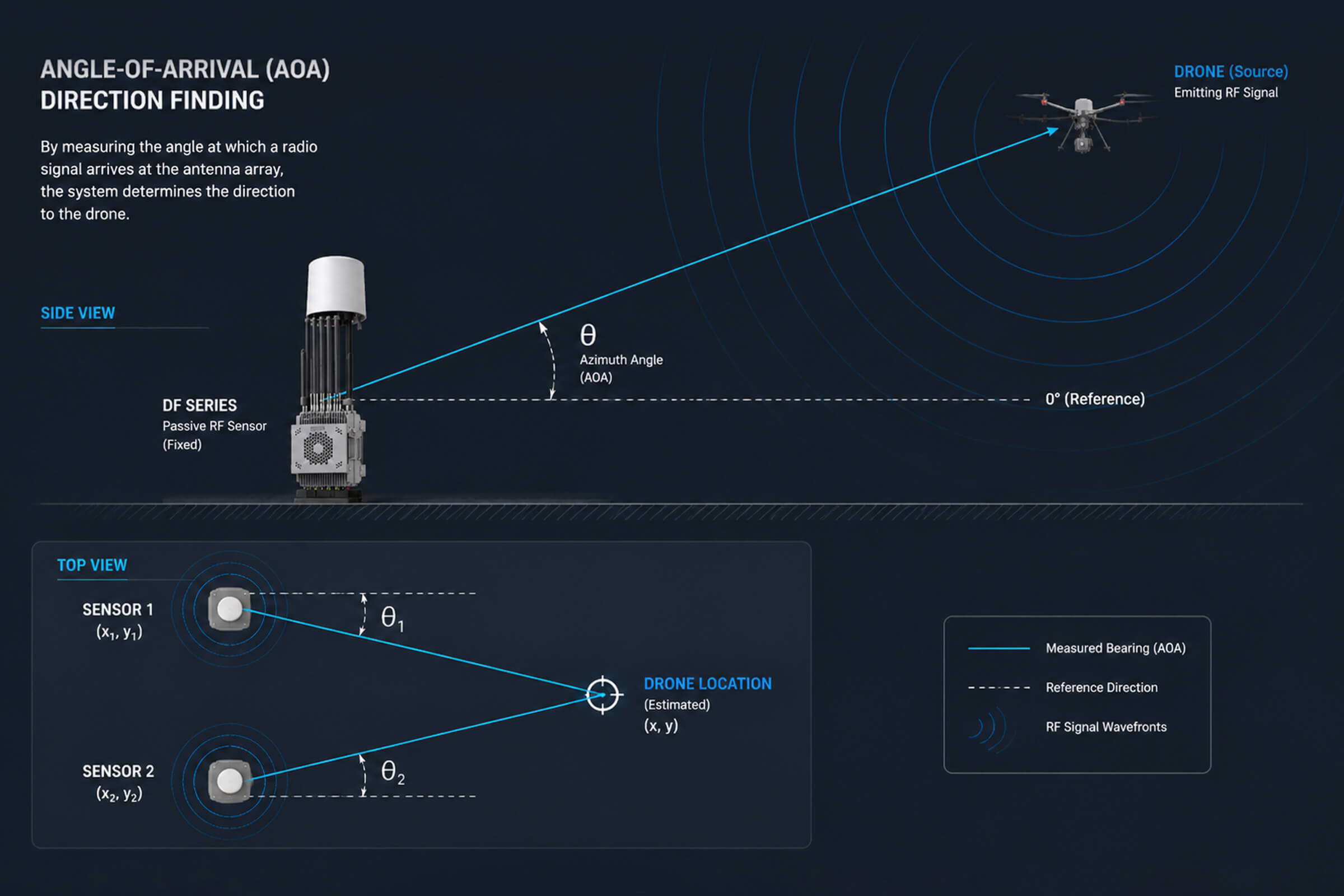
Angle-of-arrival, or AOA, is the most straightforward way to find a radio source. An AOA sensor uses an antenna array. When a drone’s signal hits the array, each antenna element receives it at a slightly different phase. The phase differences across the array tell the sensor which direction the signal came from. Modern AOA systems can resolve direction to within a few degrees.

A single AOA sensor gives you a bearing line. That is a line drawn from the sensor in the direction of the signal. It tells you the drone is somewhere along that line. It does not tell you how far away it is. For a security operator, this is enough information to start scanning the sky in the right direction, but not enough to send a response team to a specific location.

Two AOA sensors change the picture. When two sensors at known positions each produce a bearing line toward the same signal source, those lines intersect. The intersection is the drone’s position. Three sensors are better. Four eliminate ambiguity entirely in rough terrain. This is how AOA-based passive detection networks work. Each sensor is a passive RF receiver that listens and measures angle. The command platform collects the bearing lines from all nodes and computes the intersection. No sensor transmits anything at any point in the process.

LZ TECH’s DF Series fixed-site sensors are built for AOA networking. The DF chassis covers 30 MHz to 6 GHz, with a detection range of up to 8 kilometers and 360-degree coverage. Its direction-finding accuracy is 3 degrees for a hovering drone and 10 degrees for a moving target. Multiple DF nodes can be deployed around a protected site and networked together through the CCS command platform. Each node adds another bearing line to the intersection calculation, improving the position estimate with every additional sensor.

Two higher-specification variants extend the AOA concept. The DF5 Max keeps the same 30 MHz to 6 GHz range and 8-kilometer detection envelope but adds dedicated direction-finding bands at 2.4 GHz and 5.8 GHz, the frequencies where most consumer drones operate. The DF10 Max stretches the frequency ceiling to 8 GHz, widens its direction-finding band from 100 MHz to 6 GHz, and tightens accuracy to 5 degrees RMS out to 5 kilometers. Both feed into the same CCS networking logic as the base DF Series.

TDOA: when timing replaces triangulation

Angle-of-arrival works well when the sensors have clear line of sight and the drone is not moving too fast. It gets harder in dense urban environments where signals bounce off buildings and arrive at the sensor from multiple directions at once. That multipath reflection shifts the apparent phase at the antenna array and degrades the bearing measurement. In these environments, a different technique called time-difference-of-arrival, or TDOA, often produces better results.

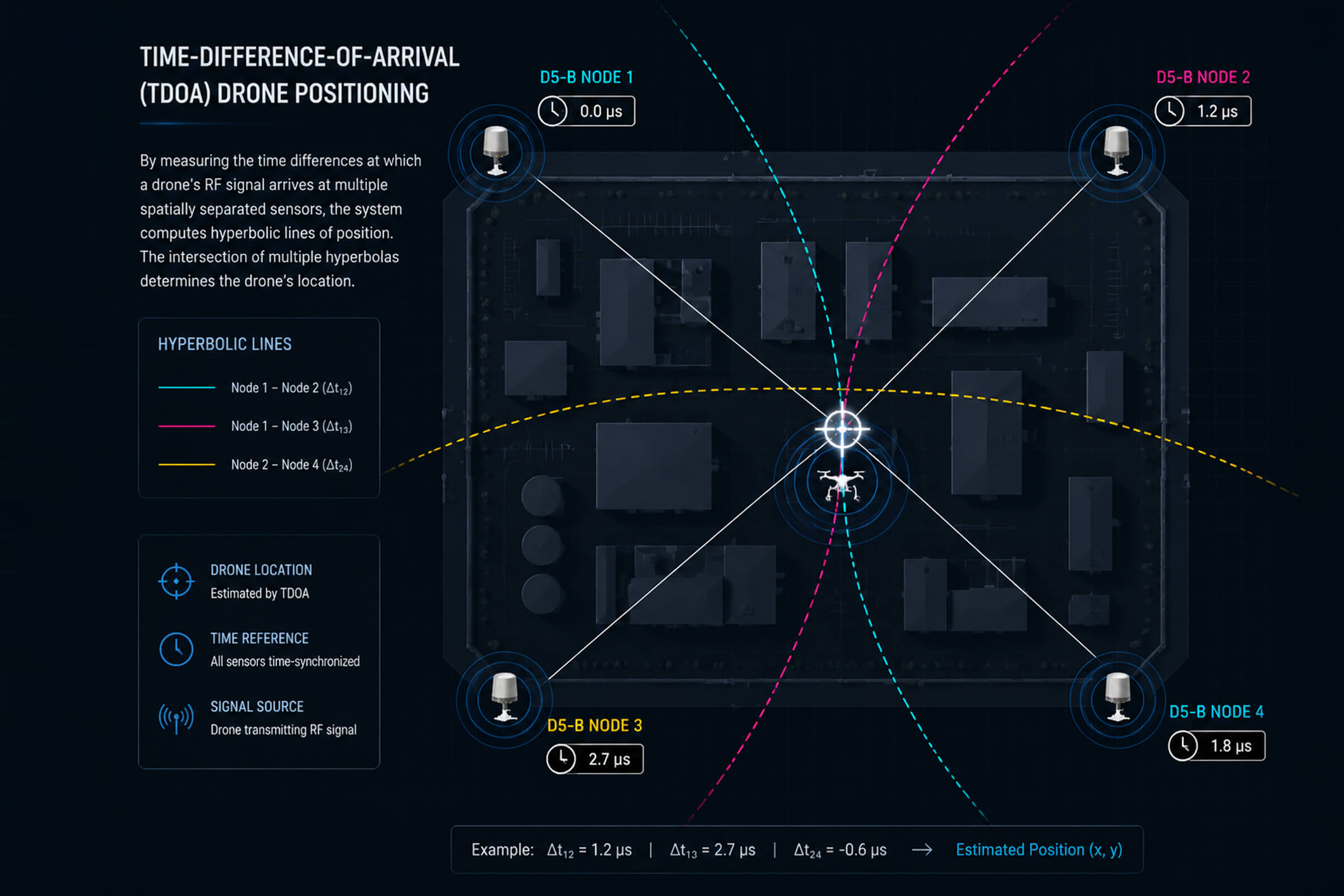
TDOA works on a different principle. Instead of measuring the angle of arrival, it measures the time a signal takes to reach each sensor in the network. Radio waves travel at the speed of light. A signal from a drone reaches a sensor that is 300 meters away about one microsecond before it reaches a sensor that is 600 meters away. A TDOA network detects these microscopic timing differences between sensor pairs.

Each pair of sensors that receives the same signal produces a hyperbola—a curve of possible source locations where the time difference matches the measurement. When multiple sensor pairs produce overlapping hyperbolas, the curves converge on a single point. That point is the drone’s position, computed purely from timing data. TDOA systems do not need directional antennas. They do not need phase-sensitive arrays. They need tightly synchronized clocks across the sensor network and a computing platform that solves the hyperbolic intersection in real time.

The D5-B is LZ TECH‘s dedicated TDOA sensor node. It is a fixed-site, network-enabled detection and positioning unit that uses passive RF sensing with TDOA computation. Multiple D5-B nodes deployed around a perimeter form a TDOA grid. Each node timestamps every signal it receives. The central platform correlates the timestamps across nodes, computes the hyperbolic intersections, and outputs a coordinate fix. The D5-B does not emit. It is undetectable by the drone it is tracking.

AOA plus TDOA: why both are better than either alone

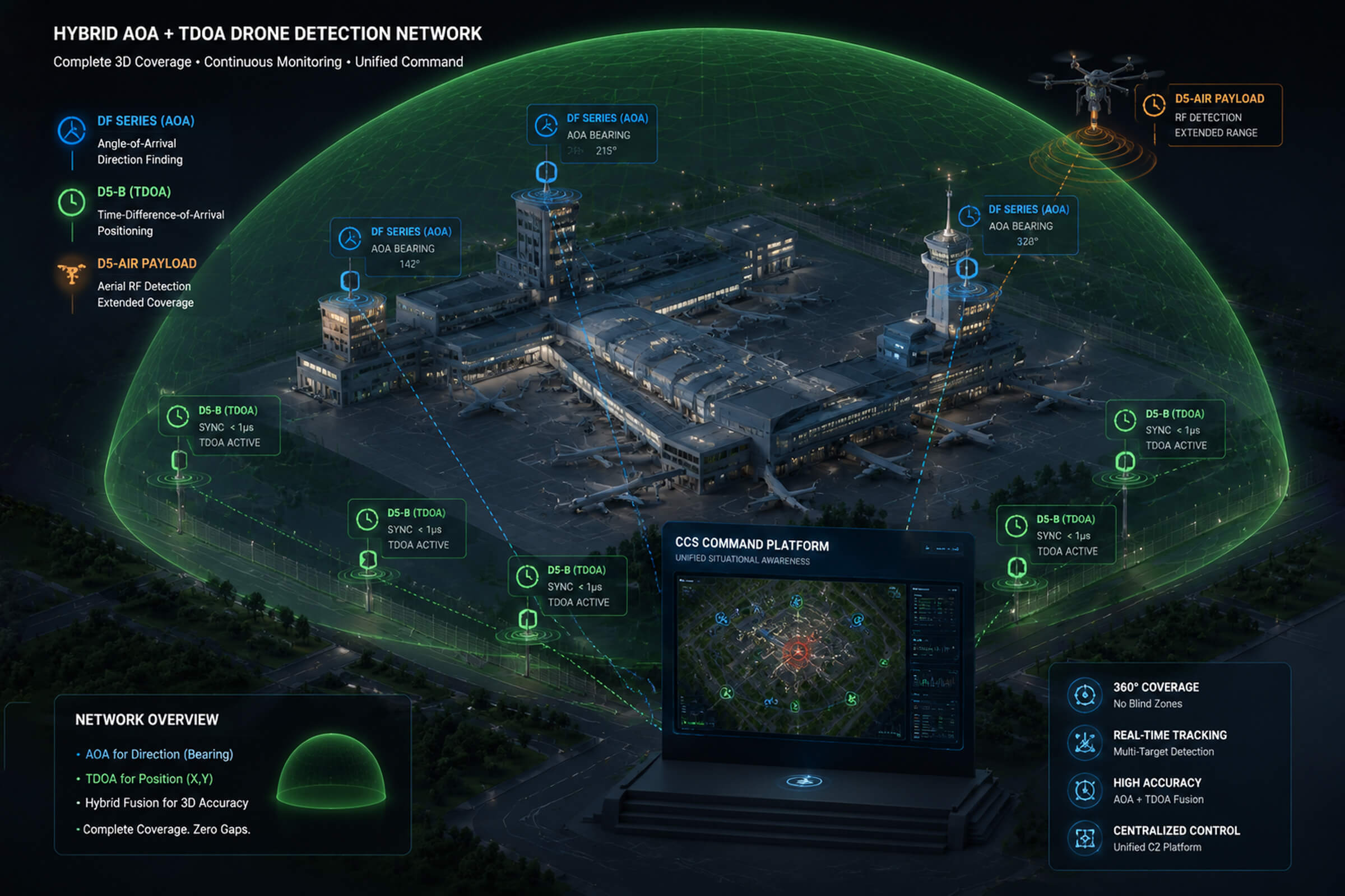
The most capable detection networks use both AOA and TDOA in combination. AOA provides a fast initial bearing estimate from a single sensor. That bearing tells the operator where to look and gives the electro-optical systems a direction to slew toward. TDOA provides a precise coordinate fix from the network, independent of multipath conditions that might degrade AOA accuracy.

The two techniques complement each other’s weaknesses. AOA is strong in open terrain with a small number of sensors. TDOA is strong in cluttered environments where bearing measurements are unreliable, but it requires more sensor nodes and careful clock synchronization. A network that runs both simultaneously gets the best of both: rapid bearing from AOA across a few well-placed nodes, and high-precision positioning from TDOA across a denser grid. The data streams merge in the command platform, which fuses the AOA bearings and TDOA hyperbolas into a single position estimate on a GIS display.

Airborne direction finding: removing the terrain blind spot

No matter how good the AOA or TDOA algorithm is, a ground-based sensor cannot detect a signal it does not receive. Buildings, hills, and terrain contours block radio line of sight. A drone flying at 80 meters behind a warehouse is invisible to a sensor on the other side of the building. Passive direction finding works with the signals it sees. It cannot invent signals it misses.

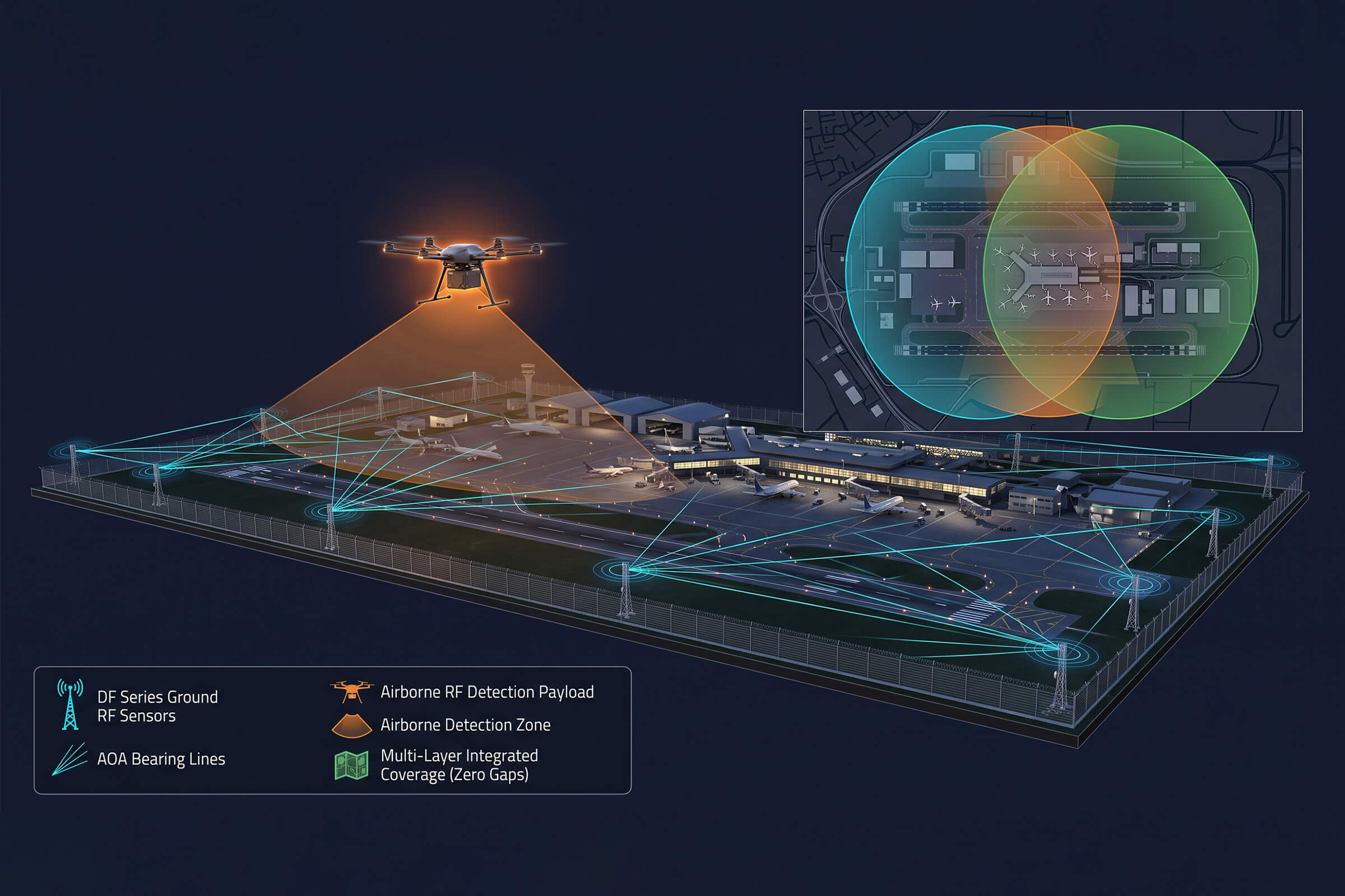
One way to solve this is to put a sensor in the air. The D5-Air is an RF detection payload that mounts on a standard commercial UAV platform, such as the DJI M400 or M350. From an airborne position, its detection band of 400 MHz to 6 GHz covers drone control and video frequencies, and its range extends up to 5 kilometers. The D5-Air does not attempt stand-alone direction finding. It feeds received signal data back to the ground station, which incorporates it into the same AOA and TDOA processing pipeline as the fixed ground nodes. An airborne node changes nothing about the underlying physics of direction finding. It just gives the network a vantage point that is not blocked by whatever is between the ground sensor and the target.

What this means for procurement decisions

Passive RF detection gives site operators a set of choices that active systems do not. Because passive sensors emit nothing, they can be deployed at airports, hospitals, and broadcast facilities where radio emissions are tightly regulated. They can operate continuously without affecting the electromagnetic environment. They do not announce their presence to the drone or its operator. The drone flies into monitored airspace without knowing it has been detected, and the security team gets a position fix before the drone gets close to anything critical.

The procurement decision breaks down into three questions: how many sensors, what type of positioning, and is airborne coverage needed.

For a small, open site with good sightlines—say a water treatment plant or a solar farm—two to three DF Series nodes running AOA networking provide adequate coverage. The terrain is flat, multipath is minimal, and AOA bearings are reliable.

For a large site or one with irregular terrain—an airport perimeter, a port facility, a border crossing—a combination of DF Series AOA nodes and D5-B TDOA nodes delivers both fast bearing and precise positioning. The AOA nodes cover the open areas quickly. The TDOA nodes handle the cluttered sections where bearings get unreliable. The CCS platform fuses them.

For a site where terrain or structures create known blind spots that ground sensors cannot resolve, adding a D5-Air airborne node extends the coverage into those shadows. The airborne node does not replace the ground grid. It supplements it, filling gaps that geometry alone prevents ground sensors from reaching.

Passive direction finding has been a core technology in signals intelligence for decades. The drone detection industry has adapted it for a new threat at lower cost and with faster deployment than the military systems it descends from. The core principle is unchanged. Listen carefully, measure precisely, emit nothing. The DF Series, the D5-B, and the D5-Air represent three different ways to do that, and for most sites, the right answer is some combination of all three.

Airborne Drone Detection Is Here: Why Multi-Layer Defense Is Becoming the Standard

At Eurosatory 2026 in Paris, one product demo got more than the usual share of attention from counter-drone professionals: an RF detection payload mounted on a quadcopter, flying above the exhibition grounds and feeding live drone positions to a ground station. The product is the Hawk T1 from Aaronia, and it represents something that has been discussed in white papers for years but rarely seen in production: airborne drone detection.

Putting a sensor in the air is not a gimmick. It addresses a real physical limitation that every ground-based system faces. Radio frequency signals at the frequencies drones use travel mostly by line of sight. Trees, buildings, terrain contours, and even the curvature of the Earth cut into detection range. A sensor elevated by 100 meters sees over those obstacles. A sensor on a drone that can reposition itself sees even more.

The Hawk T1 is a compact RF unit designed to be carried by a standard commercial UAV platform. It scans the 400 MHz to 6 GHz spectrum, the same range that covers DJI OcuSync, Autel SkyLink, and most common DIY drone video links. It feeds its findings back to a command interface on the ground. The concept is straightforward: instead of waiting for a drone signal to reach a fixed mast, you send the sensor to where the signal is easier to catch.

One layer was never enough

For the first few years of the counter-drone industry, the typical deployment looked like this: mount an RF sensor on a pole, point it at the sky, and wait. This worked reasonably well for flat, open sites like airports and desert borders. It worked less well in urban environments, forested areas, and anywhere with significant vertical structures.

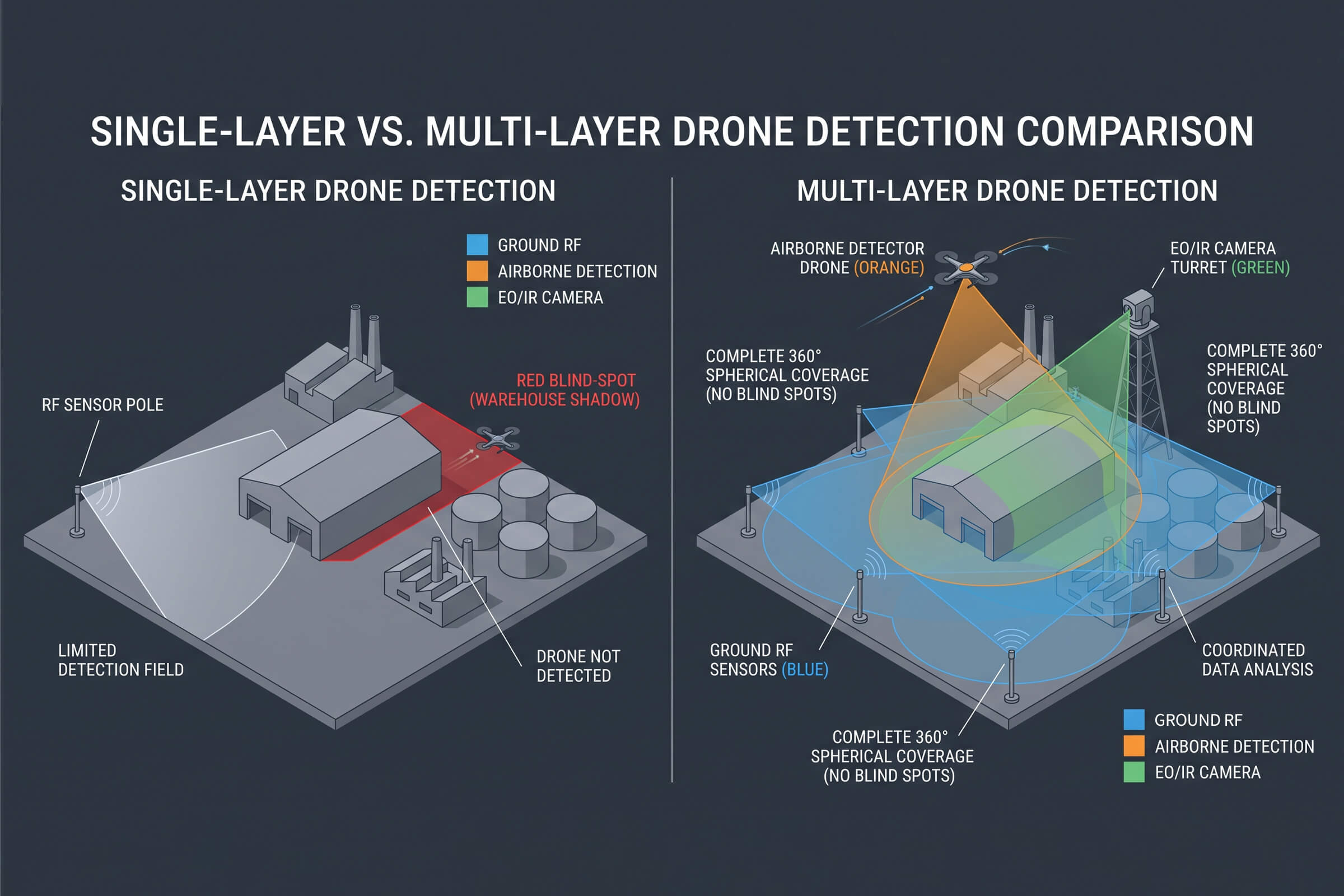
The physics of ground-based RF detection create three persistent problems. First is terrain shadowing. A drone flying low behind a hill or a row of warehouses is simply invisible to a sensor sitting at ground level. Second is multipath interference in cities, where signals bounce off buildings and arrive at the sensor from multiple directions, degrading direction-finding accuracy. Third is the inverse-square law itself. Signal power drops with distance, and at ranges beyond a few kilometers, even a high-gain antenna struggles to pull a consumer drone’s control signal out of the noise floor.

Airborne detection does not solve all of these problems, but it addresses the first one directly. A sensor at 120 meters altitude has a radio horizon of roughly 40 kilometers, compared to about 5 kilometers for a sensor mounted 2 meters above ground. The gain in effective coverage is not linear. It is geometric.

The Hawk T1 is not the only recent development pushing toward multi-layer architectures. Across the industry, the conversation has shifted from ‘which single sensor technology is best’ to ‘how do we combine sensors at different altitudes and modalities to create coverage that has no gaps?’ This is not about replacing ground sensors. It is about filling the spaces they miss.

How LZ TECH builds the layers

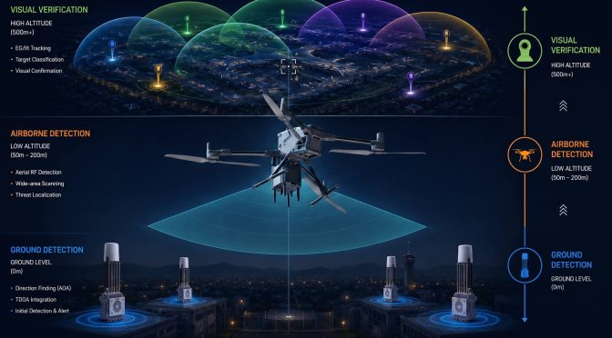
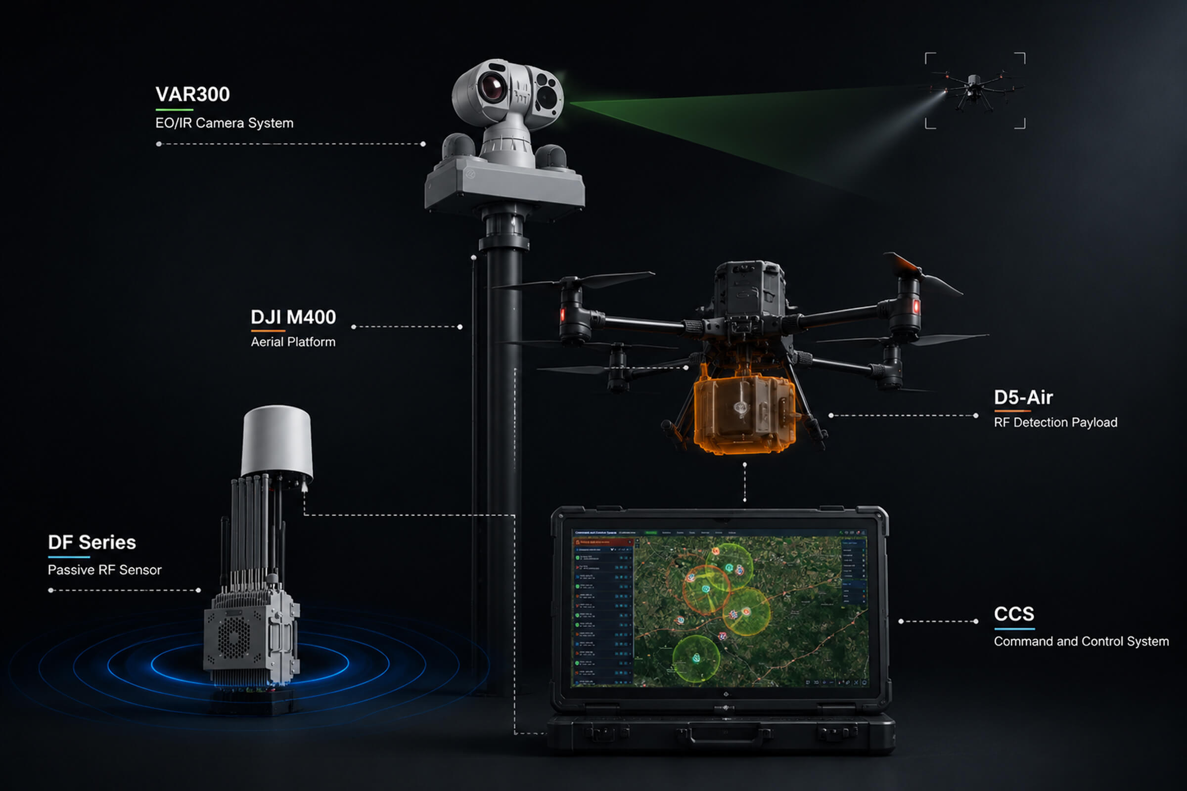
LZ TECH’s product line was designed with multi-layer detection in mind, even if the company does not always market it that way. Consider three products that, when deployed together, create detection coverage from ground level to airborne to electro-optical verification.

The DF Series is the ground layer. Operating from 30 MHz to 6 GHz with a detection range of up to 8 kilometers, these fixed-site passive RF sensors form the backbone of a networked detection grid. The DF Series uses angle-of-arrival direction finding with an accuracy of 3 degrees for a hovering drone and 10 degrees for a moving target. When multiple DF nodes are networked together, TDOA positioning narrows the location estimate to a precise coordinate. Because the DF Series is entirely passive and receives only, it emits no signals and presents no interference risk to surrounding communications. A 360-degree detection envelope means nothing slips through a gap in the azimuth coverage.

The D5-Air is the airborne layer. It is an RF detection payload designed to mount on a commercial UAV platform such as the DJI M400 or M350. Its detection band spans 400 MHz to 6 GHz, and it achieves a detection range of up to 5 kilometers from the airborne position. The prototype drone is not included in the product. The customer supplies their own UAV and mounts the D5-Air payload, making the total system cost dependent on the platform choice. Once airborne, the D5-Air extends the detection footprint vertically and horizontally, covering terrain shadows and urban canyons that a ground node cannot reach. It feeds real-time intelligence back to the command center, turning a blind spot below a hill or behind a stadium wall into monitored airspace.

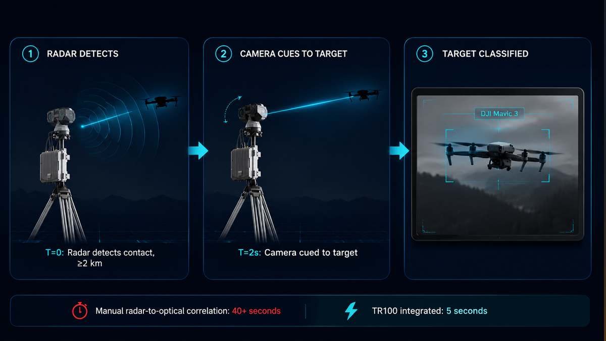
The VAR300 is the verification layer. RF detection tells you a drone is present and gives you coordinates. But for a security team that needs to decide whether to escalate, coordinates are not enough. They need visual confirmation. The VAR300 is a fixed electro-optical and infrared surveillance system that operates continuously, 24 hours a day. In daylight, it detects a DJI Mavic 3 at 1 kilometer or more and tracks it beyond 1.5 kilometers. At night, its VOx uncooled infrared detector with 640 by 512 resolution picks up the same target at 500 meters for detection and 800 meters for tracking. The built-in AI recognition engine distinguishes drones from birds and other moving objects, reducing false alarms. When a DF Series node passes a target coordinate to the VAR300, the camera slews automatically to the bearing and begins tracking before a human operator even touches a control.

These three layers are not theoretical. They are products that exist today and ship to customers in over 60 countries. The DF Series detects. The D5-Air goes where ground sensors cannot. The VAR300 confirms. Together they form a detection architecture that addresses the line-of-sight problems a single ground sensor cannot solve.

The real question is integration, not sensor count

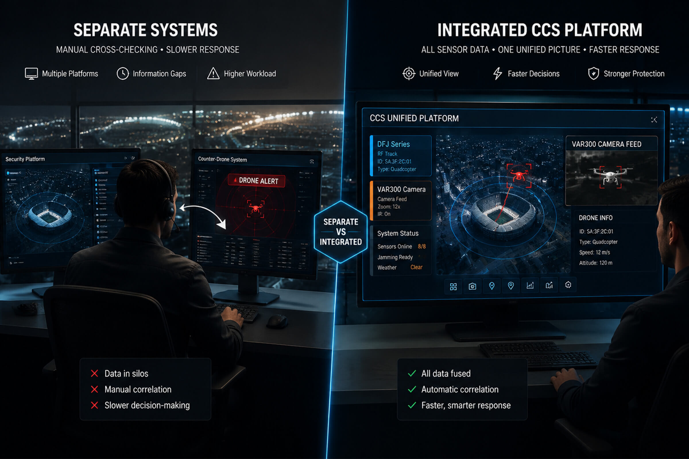
Adding an airborne sensor sounds appealing. It also adds complexity. Every additional sensor layer generates more data. Without a command and control platform that fuses inputs from multiple sensor types into a single operational picture, the operator ends up staring at three different screens with three different coordinate systems, trying to figure out whether sensor A and sensor B are looking at the same drone or two different ones.

This is where the software layer matters as much as the hardware. LZ TECH’s CCS and CRPCS platforms ingest detection data from the DF Series ground nodes, the D5-Air airborne payload, and the VAR300 electro-optical tracker, then fuse them into a single geospatial display. An operator sees one map with all targets overlaid, not three separate feeds. When a drone appears simultaneously on two DF nodes and the D5-Air, the system correlates the tracks and presents a single threat icon rather than three confusing dots. The software handles the sensor fusion so the operator can focus on decisions.

The industry’s movement toward multi-layer architectures is a natural evolution. Ground sensors alone were a reasonable starting point when the drone threat was simpler, and the counter-drone market was smaller. But as drones get faster, smaller, and more autonomous, and as the environments they operate in get more complex, detection architectures need to match. Airborne sensors like the Hawk T1 are a signal that the market is ready for this next step. The companies that already have the ground, airborne, and verification layers in production are the ones positioned to deliver it.

LZ TECH’s approach to multi-layer detection follows a simple principle: every sensor modality covers the gaps of the others. RF detects at range but can struggle with terrain. Airborne eliminates terrain shadowing but has limited flight time. Electro-optical confirms identity but needs a target bearing to start its search. Combined, the gaps close. The result is detection coverage that a single sensor, no matter how advanced, cannot provide on its own.

Four Signals the Counter-Drone Market Is Entering a Procurement Phase in 2026

For years, the counter-drone industry has been described as emerging, growing, and on the verge of a breakout. Those descriptions were accurate for a market where most activity consisted of pilot programs, trial deployments, and small-scale procurements by early-adopter government agencies. In 2026, the evidence suggests the market is no longer emerging. It is accelerating into a phase of institutional procurement and industrial scale.

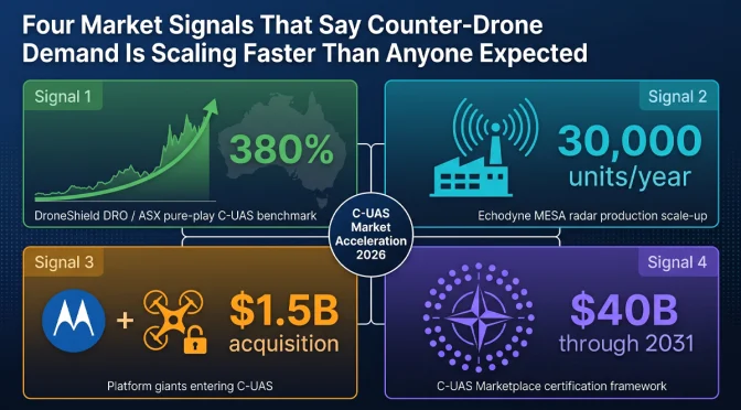
Four signals from the first half of 2026 make the case. They come from different corners of the industry: a publicly traded pure-play counter-drone company, a radar manufacturer committing to volume production, a major acquisition by a public safety technology company, and a multilateral defense procurement framework. Each signal is meaningful on its own. Together, they describe a market that has moved from pilots to programs.

Signal 1: DroneShield’s Revenue Growth Shows Institutional Procurement at Scale

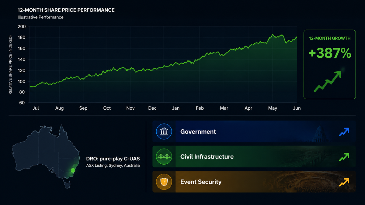
DroneShield, the Australian counter-drone company listed on the Australian Securities Exchange, has reported significant revenue growth over the past several years. The company’s trajectory is notable because it is one of the few pure-play counter-UAS companies with publicly available financial data. Its growth rate provides a window into how quickly government procurement budgets for counter-drone systems are expanding globally.

The company’s revenue has grown at triple-digit percentage rates in recent reporting periods. This is not the growth profile of a company winning a handful of evaluation contracts. It is the profile of a company converting pilot programs into recurring procurement orders. Government customers that previously bought a few units for testing are now ordering systems for operational deployment across multiple sites and, in some cases, across multiple branches of their security forces.

The pattern is consistent across DroneShield’s geographic markets. The company has reported contracts in North America, Europe, the Middle East, and the Asia-Pacific region. The diversity of its customer base suggests that the shift from evaluation to procurement is not limited to one country or one type of end user. It is a global phenomenon.

For the broader counter-drone industry, DroneShield’s financial results serve as a public benchmark. If the only pure-play public company in the sector is growing at triple-digit rates, it strongly suggests that privately held competitors are experiencing similar demand. The rising tide is lifting multiple companies, not just one.

What makes this signal particularly meaningful is that government procurement cycles are slow by nature. A defense or security agency typically takes 12 to 24 months to move from initial evaluation to a signed procurement contract, and another 6 to 12 months to receive and deploy equipment. The growth that DroneShield is reporting now reflects procurement decisions that were initiated two to three years ago. If those early decisions are now converting to revenue at scale, the procurement pipeline for the next two to three years is likely even larger, because the number of agencies that have begun evaluation programs has only increased since then.

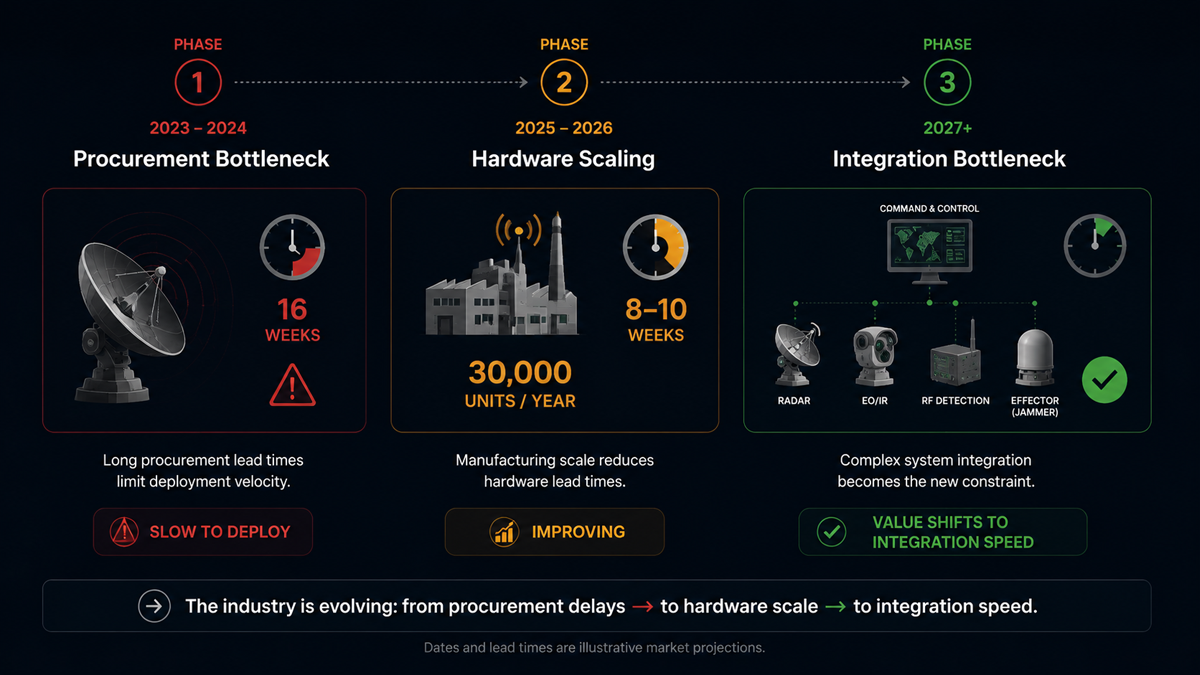
Signal 2: Echodyne’s 30,000-Unit Radar Factory Signals Industrial-Scale Production

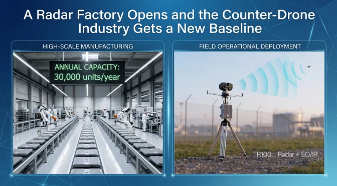
As discussed in more detail in our separate analysis of the TR100 integrated radar platform, Echodyne opened a new production facility in 2026 with an annual capacity exceeding 30,000 MESA radar units. The MESA radar is a compact phased-array system used extensively for drone detection, perimeter security, and border surveillance applications.

A 30,000-unit annual capacity is not a facility sized for boutique defense programs that order radar systems in dozens or low hundreds. It implies that the manufacturer expects demand at a scale that did not previously exist for this class of sensor. For comparison, a typical large defense radar program might order 200 to 500 units over a five-year period. Thirty thousand units per year is two orders of magnitude larger than that.

The investment in volume production capacity is a bet that counter-drone radar will become standard equipment at critical infrastructure sites worldwide, not a specialized capability reserved for high-value military installations. If that bet is correct, the addressable market for this class of sensor will expand dramatically within the next several years.

The factory expansion also has implications for unit economics. Volume production drives down per-unit cost through manufacturing efficiency, supply chain optimization, and amortization of fixed costs over a larger production base. Cheaper radar units expand the addressable market further by making the technology accessible to budget-constrained customers such as municipal police departments, private security firms, and smaller critical infrastructure operators. This creates a virtuous cycle: more production lowers unit cost, which expands the market, which supports more production.

For counter-drone system integrators like LZ TECH, the availability of more affordable radar sensors from multiple suppliers is a positive development. It means that integrated detection systems can be priced at levels that a broader range of customers can afford, accelerating the overall market growth that benefits the entire industry.

Signal 3: Motorola Solutions Acquires D-Fend Solutions for Approximately $1.5 Billion

In June 2026, Motorola Solutions announced the acquisition of D-Fend Solutions, an Israeli counter-drone company known for its radio-frequency cyber-takeover technology, for approximately $1.5 billion. This is the largest acquisition in the counter-drone sector to date, and it carries several implications for the market.

First, the acquirer matters as much as the price. Motorola Solutions is a public safety and enterprise security company, not a defense prime contractor. Its customer base consists of police departments, fire services, airports, utilities, and corporate security teams. Motorola sells two-way radios, body cameras, command-center software, and video security systems to thousands of public safety agencies worldwide. The decision to acquire a counter-drone company signals that Motorola sees drone threats as a mainstream public safety problem that its existing customers need to address, not a niche military concern.

Second, the $1.5 billion valuation demonstrates that the financial market now places counter-drone technology companies in the same category as established security technology firms. A billion-dollar acquisition in this sector would have been considered unlikely even three years ago. Today, it has happened. This changes how investors, potential acquirers, and company founders think about the value of counter-drone technology businesses.

Third, Motorola’s distribution network is one of the most extensive in the public safety industry. The company has direct sales relationships with thousands of law enforcement agencies, airport authorities, and critical infrastructure operators across more than 100 countries. D-Fend’s counter-drone technology, combined with Motorola’s sales channels and existing customer relationships, could accelerate the adoption of counter-drone systems by local and regional agencies that have not previously had practical access to this class of equipment.

Fourth, the acquisition signals that counter-drone technology is being absorbed into the broader public safety technology stack. Rather than existing as a standalone discipline with specialized vendors, drone defense is becoming one module within an integrated security platform. Motorola’s command-center software, video management systems, and communication platforms will likely integrate D-Fend’s drone detection and mitigation capabilities, creating a unified security operations interface that includes counter-drone as a standard feature.

Signal 4: NATO’s $40 Billion C-UAS Marketplace Framework

NATO has established a Counter-UAS Marketplace framework with a reported total value of approximately $40 billion. The framework is designed to streamline procurement of counter-drone systems across NATO member states, reducing the administrative overhead of individual national procurement programs and enabling interoperability between allied counter-drone systems.

The significance of this framework extends well beyond the headline dollar figure. It represents a formal recognition at the alliance level that counter-drone capability is now a baseline requirement for modern military forces, comparable to armored vehicles, communication systems, or electronic warfare equipment. A multilateral procurement framework of this size would not be established for a capability that NATO considered experimental or optional.

The framework approach addresses a long-standing problem in defense procurement: fragmentation. Historically, each NATO member state has procured counter-drone systems independently, using its own requirements, its own testing standards, and its own contract vehicles. This results in a patchwork of incompatible systems that cannot share data, cannot coordinate responses, and cost more to acquire and maintain because each national program bears its own overhead.

A centralized marketplace framework solves these problems in several ways. It establishes common technical standards that all participating systems must meet. It creates a pre-qualified vendor list that reduces the procurement timeline for individual member states. It drives interoperability by requiring that all systems procured through the framework can exchange data and coordinate operations. And it aggregates demand, giving NATO member states collective purchasing power that individual nations cannot achieve alone.

For counter-drone manufacturers, a procurement framework of this size creates a structured and predictable market. Companies that can meet NATO’s technical and interoperability requirements gain access to a pipeline of orders across multiple member states. Instead of competing separately in 30 different national procurement processes, they qualify once and are listed for all participating nations. This dramatically reduces the sales cost and timeline for accessing NATO markets.

The framework also encourages investment in research and development. A company that knows it has a clear path to market for a system that meets NATO standards is more likely to invest in developing that system. The framework reduces the risk that a technically superior product will fail commercially because the manufacturer could not manage dozens of separate national procurement bureaucracies.

What These Four Signals Mean Collectively

Viewed individually, each of these signals could be dismissed as a single data point. A company reports strong revenue. A manufacturer expands a factory. Another company gets acquired by a larger player. A military alliance sets up a procurement framework. Any one of these events, on its own, is interesting but not conclusive.

Viewed together, they describe a market that is crossing an important threshold. The counter-drone industry is moving from a collection of technology demonstrations and small-scale deployments to an established sector with institutional buyers, billion-dollar valuations, volume manufacturing, and multilateral procurement structures. The market infrastructure that supports large-scale industrial activity is being built: standardized requirements, pre-qualified vendor lists, interoperable architectures, and distribution channels that reach thousands of end-user organizations.

The practical implication for end users is that counter-drone equipment is becoming more accessible, more standardized, and more interoperable. The days of every deployment being a bespoke integration project are numbered. The practical implication for the industry is that the window for entering the market as a new participant is narrowing. Companies that already have production hardware, established supply chains, and field-proven technology are positioned to capture the procurement wave that is now building. Companies still in the prototype phase face an increasingly competitive field with higher barriers to entry.

LZ TECH’s Position in the Accelerating Market

LZ TECH has been building counter-drone detection and defense systems for the global market since its founding. The company supplies OEM modules to system integrators, operates the CCS command-and-control platform for multi-sensor integration, and has established a presence in over 60 countries with more than 6,000 partners.

The product portfolio spans portable detection devices like the H3 Pro and HD5, integrated radar and EO/IR platforms like the TR100, and a range of RF detection and jamming modules that system integrators can incorporate into their own solutions. The CCS platform provides the software layer that connects these sensors into a unified operational picture, handling sensor fusion, alert prioritization, and automated response workflows.

As the market accelerates from pilots to procurement, the companies that succeed will be those with production-ready hardware across multiple sensor categories, established global distribution and support networks, and a software platform that integrates sensors from different manufacturers. LZ TECH has invested in all three areas over multiple years and across multiple product generations. The company is positioned to supply both end-user organizations that need complete systems and integrators that need OEM modules to build their own solutions, serving customers ranging from national defense agencies to commercial security providers operating at airports, ports, and energy facilities.

What to Expect Through the End of 2026 and Into 2027

The four signals described above are unlikely to be the last major market developments in 2026. Several trends suggest continued market acceleration.

Regulatory mandates for drone detection at critical infrastructure sites are under active consideration in multiple jurisdictions. The European Union, the United Kingdom, several Middle Eastern states, and parts of Asia are developing or have recently enacted regulations that require certain categories of infrastructure operators to maintain drone detection and response capability. If these mandates continue to expand, they will create a new category of demand from civilian infrastructure operators who have not previously been buyers of counter-drone equipment. This is a large addressable market that has barely been tapped.

The growing availability of counter-drone systems at price points accessible to municipal police departments and private security firms will further expand the addressable market beyond national defense agencies. Motorola’s entry into the market through the D-Fend acquisition is a leading indicator of this trend. When counter-drone capability becomes available through the same sales channels that supply police radios and body cameras, adoption by local law enforcement will accelerate rapidly. A police department that already buys Motorola radios is a natural customer for a Motorola-integrated counter-drone solution.

Standardization of sensor interfaces and command-and-control protocols, driven by frameworks like the NATO C-UAS Marketplace, will reduce integration costs and make it easier for end users to combine sensors from multiple manufacturers. This benefits the entire industry by reducing the friction of deploying multi-sensor systems and by creating a larger market for interoperable components. It also benefits end users by giving them more choice: a standardized interface means they can select the best sensor for each function rather than being locked into a single vendor for all components.

The counter-drone market in 2026 is not what it was in 2023. The evidence from financial markets, manufacturing investment, merger and acquisition activity, and defense procurement frameworks all points in the same direction. The industry is entering its next phase, and the companies that built production capability and global distribution during the earlier pilot phase are the ones positioned to supply the procurement wave that is now arriving.

For end users evaluating counter-drone solutions, the market conditions described here have practical implications. More competition and larger production volumes mean better equipment at lower cost. Standardized procurement frameworks mean faster acquisition timelines. Integration with established public safety platforms means simpler deployment and lower training requirements. The maturation of the counter-drone market is good news for the organizations that need these systems to protect their people, assets, and operations from drone threats that continue to grow in number and sophistication.

The counter-drone industry has spent the better part of a decade building the technology foundation. Now the market infrastructure is catching up: procurement frameworks, integration standards, distribution channels, and the institutional awareness needed to turn technical capability into operational deployment. The next chapter of this industry will be written not in research labs, but in the field.

How to Choose Portable Drone Detection Equipment: A Practical Guide to H3 Pro and HD5

When a security team needs to find a drone that just appeared over their facility, they care about two things: where exactly the drone is, and who is flying it. A compass bearing that points toward the general direction of the signal is not enough. In a dense urban environment or a sprawling industrial site, a bearing angle could correspond to any building within a wide arc, spanning hundreds of meters of uncertainty.

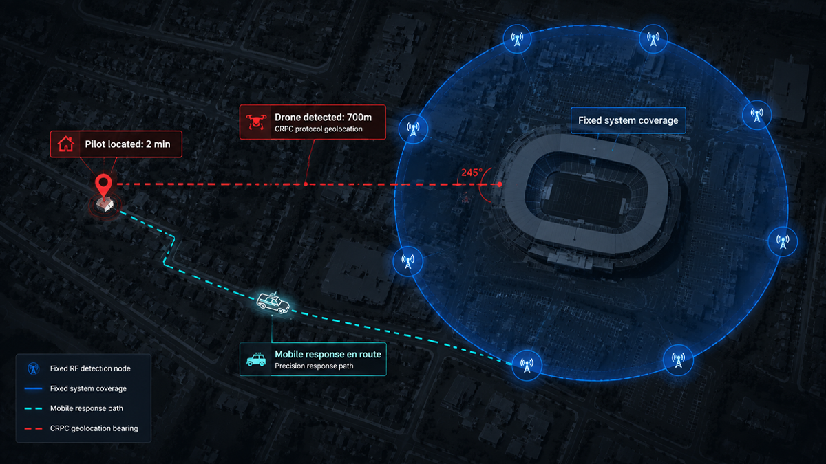
This is where protocol-based drone detection makes a critical difference. LZ TECH’s portable detection devices do not rely on antenna arrays to estimate an angle of arrival. Instead, they receive and decode the drone’s own telemetry transmissions to extract precise GPS coordinates, serial number, model, altitude, and speed. The result is not a rough direction. It is an exact location and a confirmed identity.

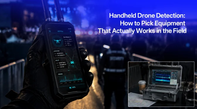
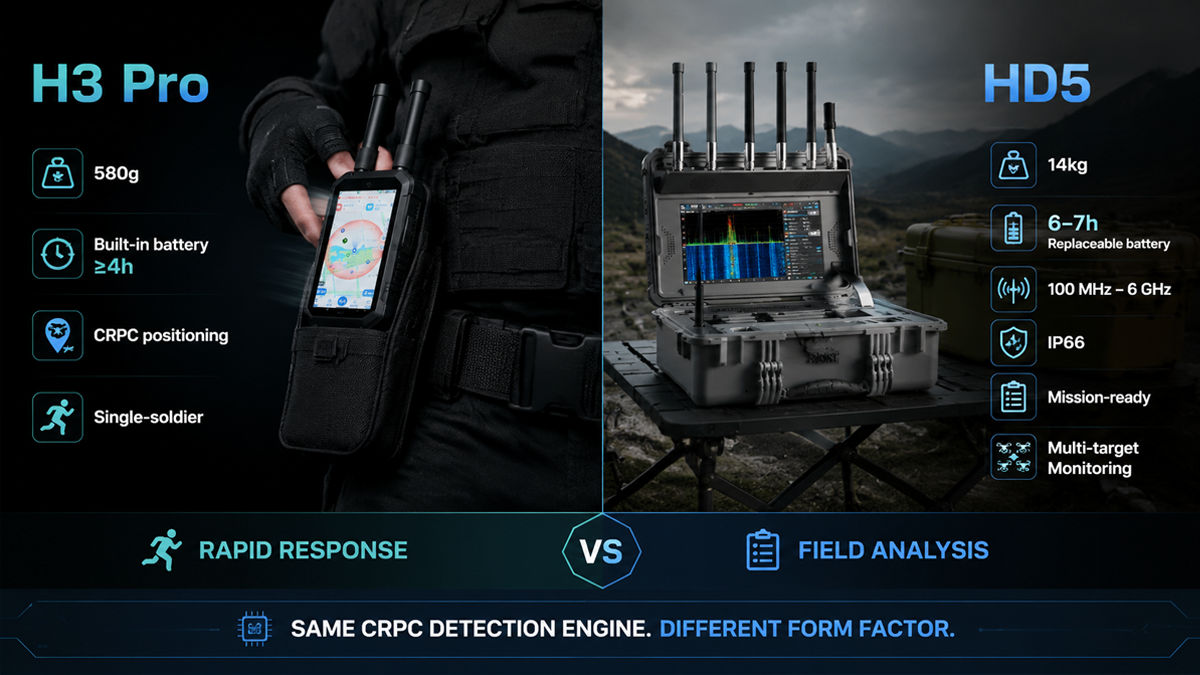
This guide compares two portable detection form factors from LZ TECH: the H3 Pro, a 580-gram single-soldier unit, and the HD5, a 14-kilogram portable system in a rugged case. Both use the same CRPC protocol decoding engine. The choice between them depends on the mission profile, not on detection capability. This article explains the technology, the specifications, and the operational factors that should guide the decision.

The Core Technology: Protocol Parsing Versus Direction Finding

To understand why protocol parsing matters, it helps to understand the alternative. Traditional drone detection systems use antenna arrays to measure the angle from which a radio signal arrives. By comparing the phase difference of a signal received across multiple antennas, the system can estimate a bearing. This technique is called direction finding, and it has been used in electronic warfare for decades.

Direction finding works reasonably well for strong, continuous signals in open terrain. But it has fundamental limitations when applied to drone detection. The bearing accuracy is typically 5 to 15 degrees. At a range of 1 kilometer, a 10-degree bearing error translates to an uncertainty zone roughly 175 meters wide. In an urban environment with buildings that reflect and scatter radio signals, the accuracy can degrade further due to multipath propagation.

Furthermore, a bearing angle tells you approximately where the drone is but nothing about what it is. You do not get the drone model, serial number, or the location of the remote controller. All you know is that a signal of a certain type is coming from a certain general direction. This is useful but incomplete information for a security response.

Protocol parsing works on a completely different principle. Modern drones continuously broadcast telemetry data during flight. This data includes the drone’s GPS position, altitude, speed, heading, battery level, serial number, and model identification. Some protocols also transmit the GPS position of the remote controller, which is the location of the pilot operating the drone.

This telemetry is transmitted through standard communication protocols. CRPC is a common drone communication protocol suite used by several major manufacturers. Remote ID (RID) is a regulatory requirement in many jurisdictions that mandates drones to broadcast identification and location data. DroneID is a proprietary protocol used by DJI for remote identification.

A detection device that can receive and decode these protocols can read the drone’s own navigation data directly from its transmissions. The device does not need to estimate anything from the signal angle. It simply reads what the drone is already broadcasting about itself.

The practical advantage is immediate and significant. Instead of a bearing angle that points somewhere within a large sector, the operator sees a dot on a map showing the drone’s current GPS position and, where available, the remote controller’s position. The device also displays the drone model, serial number, flight altitude, and speed. This is actionable intelligence that enables a directed response.

H3 Pro: The 580-Gram Tactical Single-Soldier Unit

Form Factor and Physical Specifications

The H3 Pro weighs 580 grams or less without the antenna, and approximately 46 grams per antenna module. With dimensions of 177 millimeters by 89 millimeters by 30 millimeters, it is roughly the size of a large smartphone or a small tablet. It fits in a cargo pocket, a small pouch on a plate carrier, or a compact equipment bag.

This is the lightest form factor in LZ TECH’s detection product line. For a dismounted soldier or a patrol officer who is already carrying body armor, a weapon, communications gear, and other equipment, every gram counts. A 580-gram detection device is negligible compared to the burden of carrying a tripod-mounted antenna array or a laptop-sized detection system.

The device features a 6-inch display screen for viewing the tactical map, drone list, and alert information. The screen is large enough to provide clear situational awareness at a glance while keeping the overall device compact enough for handheld or body-worn use.

Battery and Runtime

The H3 Pro uses a built-in lithium battery with a capacity of 12,000 milliampere-hours. Continuous runtime is 4 hours or more under normal operational conditions. The device supports charging while in use, so an operator can connect an external power bank during extended missions without powering down the device. The battery is internal and not designed to be swapped in the field. The charge-while-operating feature addresses the need for missions that exceed 4 hours.

This battery design is appropriate for the H3 Pro’s role as a lightweight personal device. A removable battery would add bulk, weight, and mechanical complexity. For the typical mission profile of a dismounted operator, 4 hours of runtime with the option to extend via external power covers the vast majority of operational scenarios.

Detection Specifications

Frequency coverage includes the 800 MHz and 900 MHz bands, 1.2 GHz, 2.4 GHz, 5.2 GHz and 5.8 GHz, and Wi-Fi bands. These discrete bands cover the most common drone communication frequencies used by commercial and consumer drones worldwide. The frequency selection is optimized for weight and power efficiency: it covers the bands where the vast majority of drones operate, without the power consumption and antenna complexity of full continuous spectrum coverage.

Detection range is up to 3 kilometers, depending on terrain, signal conditions, and the drone’s transmission power. In open terrain with line of sight to the drone, the full 3-kilometer range is achievable. In urban or obstructed environments, the practical range depends on signal propagation through buildings and other obstacles.

The device can simultaneously detect 15 or more drones and maintain trajectory tracking for 11 or more drones. Position accuracy is 3 meters RMS or better, with a response time of 5 seconds or less from signal detection to alert display.

The H3 Pro is a passive detection device. It receives signals only and emits nothing, making it electronically undetectable by the drone operator. There is no transmission that could reveal the operator’s position or trigger countermeasures.

It also supports analog FPV video transmission decoding, allowing the operator to view the drone’s own camera feed when the drone transmits analog video on standard frequencies. This provides an additional layer of situational awareness: the operator can see what the drone’s pilot sees, confirming the drone’s observation target and intent.

Deployment Model

The H3 Pro is designed for single-soldier use: one device per operator, providing personal situational awareness in the field. Each operator sees their own tactical display and can operate independently.

Through LZ TECH’s control platform, multiple H3 Pro units can collaborate as a networked detection grid. Each unit shares its detections with all other units on the network, enabling a team to build a common operating picture that shows every drone detected by any operator, regardless of which individual device received the signal. This networked mode turns a collection of individual devices into a distributed sensor network without requiring a central command post or vehicle-mounted server.

HD5: The 14-Kilogram Portable System in a Case

Form Factor and Physical Specifications

The HD5 is a different category of portable equipment. It weighs 14 kilograms including the battery and is housed in a rugged transport case measuring 470 millimeters by 357 millimeters by 176 millimeters when closed. The case carries an IP66 rating when closed, providing complete protection against dust ingress and powerful water jets from any direction.

This is not a handheld device. It is a portable system that one or two people can carry to a deployment site, set up in a few minutes, and operate from a fixed position or from inside a vehicle. The 14-kilogram weight includes everything needed for operation: the processing unit, the 13.3-inch touchscreen display, the antenna array, and the battery.

The HD5 features a foldable antenna interface for rapid deployment. The operator opens the case, unfolds the antennas, powers on the system, and the device is operational. The 13.3-inch touchscreen provides a large, detailed operator interface suitable for sustained monitoring over a full shift.

The modular design supports extension through additional hardware modules, allowing the system to be configured for specific mission requirements. The IP66 rating means the system can operate in rain, dust, and harsh outdoor conditions when the case is appropriately configured for deployment.

Battery and Power

The HD5 operates from either a built-in lithium battery or AC mains power at 110 to 240 volts. This dual power capability means it can run on battery for mobile or remote deployments, or plug into grid power for fixed-site or vehicle-based operations with unlimited runtime.

Battery runtime is 6 to 7 hours, covering a full operational shift. The battery uses a plug-in replaceable design: the operator can remove the battery pack and replace it with a charged spare unit. This is not a hot-swap mechanism. The system should be powered down before the battery is replaced. A team that maintains a charged spare battery can achieve near-continuous operation by swapping batteries between shifts or during planned downtime.

The 6-to-7-hour runtime is well-matched to the HD5’s role as a vehicle-mounted or fixed-position sensor. Unlike the H3 Pro operator who may be on the move for hours at a time, the HD5 operator is typically stationary, monitoring a screen, and can manage battery changes as a planned procedure rather than an emergency swap.

Detection Specifications

The HD5 covers a continuous frequency range from 100 MHz to 6 GHz, with particular sensitivity in the main drone communication bands: 433 MHz, 900 MHz, 1.4 GHz, 2.4 GHz, 5.2 GHz, and 5.8 GHz. This continuous coverage allows the HD5 to detect drones operating on less common frequencies outside the standard ISM bands, providing broader detection coverage than the H3 Pro’s discrete band approach.

Detection range is up to 5 kilometers for CRPC, RID, and DroneID protocol signals, depending on terrain and signal propagation conditions. The HD5 shares the same CRPC protocol parsing engine as the H3 Pro, providing the same capability to extract GPS coordinates, drone identity, and remote controller position from decoded telemetry data. The detection methodology is identical. The extended range comes from the HD5’s larger antenna array and more sensitive receiver front end.

How to Choose Between H3 Pro and HD5

The decision between these two devices is not about detection quality. Both use the same protocol decoding engine and provide the same fundamental capability: precise drone GPS coordinates and identity. The decision is about the mission profile and operational constraints.

Choose the H3 Pro When:

The operator is on foot and needs to minimize carried weight. A 580-gram device that fits in a pocket is the obvious choice for dismounted patrols, tactical teams moving quickly, or any situation where every gram matters. The 4-hour built-in battery with charge-while-operating support covers typical mission durations, and external power banks are widely available and inexpensive for extended operations. The H3 Pro is the right tool for a single operator who needs personal drone awareness while moving.

Choose the HD5 When:

The deployment is vehicle-mounted or at a fixed checkpoint or observation post. The 14-kilogram weight is irrelevant when the system sits on a vehicle’s passenger seat, on a desk inside a security post, or on a tripod at a fixed observation point. The larger 13.3-inch touchscreen provides a better operator experience for sustained monitoring over hours-long shifts. The 6-to-7-hour battery life covers a full shift without external power, and the plug-in replaceable battery design allows a team to maintain continuous coverage by swapping batteries. The IP66-rated case protects the equipment during transport and when deployed in adverse weather. The wider continuous frequency coverage from 100 MHz to 6 GHz provides detection capability for drones using non-standard frequencies.

What Both Devices Deliver: Coordinates, Not Bearings

Regardless of which form factor is chosen, both the H3 Pro and HD5 provide the same fundamental capability: precise drone location and identity through protocol decoding. An operator using either device does not get a vague compass bearing. They see the drone’s exact GPS coordinates plotted on a map, along with the remote controller’s position, the drone model, its serial number, and its flight altitude and speed.

This is the difference between knowing that a drone is somewhere to the northeast and knowing that a DJI Mavic 4 with serial number X is hovering at 120 meters altitude, 850 meters away at coordinates Y, while its pilot is standing 600 meters away at coordinates Z. The second scenario enables a directed response. The first scenario only enables a search. For a security team with limited personnel and time, the difference between a search and a response can be the difference between intercepting a threat and watching it complete its mission.

The protocol parsing approach also provides legal and operational benefits. Knowing the drone’s serial number and model provides evidence that can support prosecution or incident reporting. Knowing the remote controller’s position enables law enforcement to locate and detain the pilot, which is the only way to permanently neutralize a drone threat. Jamming or kinetic interception stops the drone in the moment. Locating the pilot stops the threat at its source.

Conclusion

Portable drone detection equipment has matured from experimental prototypes to production hardware available in multiple form factors. The technology that matters most is not the antenna design or the enclosure material. It is the ability to read drone telemetry data and provide coordinates rather than bearings. Both the H3 Pro and HD5 deliver this capability, at 580 grams and 14 kilograms respectively, for two different operational profiles.

For a patrol officer who needs to know what is flying overhead right now, the H3 Pro is the answer. It is light enough to carry all day, it provides 4 hours of runtime with the option to charge while operating, and it gives the operator exact drone positions and pilot locations on a map. For a checkpoint team or a vehicle-mounted sensor operator running a full shift, the HD5 provides more screen real estate, longer battery endurance, wider frequency coverage, and weatherproofing that the smaller device cannot match. The detection engine is the same. The choice is about how you carry it and how you use it.

Echodyne’s 30,000-Unit Radar Factory Signals Mass Demand for Counter-Drone Radar – Where TR100 Fits

In mid-2026, radar manufacturer Echodyne opened a new production facility with an annual capacity exceeding 30,000 MESA radar units. It is a significant signal for anyone watching the counter-drone industry: the demand for small-target detection radar is no longer experimental or niche. It is moving into volume manufacturing.

A factory producing 30,000 radar units per year represents a structural shift in how the market thinks about drone detection sensors. For context, a typical defense radar program might order a few hundred units over its lifetime. A few thousand units over several years is considered a large program. Thirty thousand units per year is a completely different category. It means the manufacturer expects demand from multiple procurement programs running simultaneously, across different customer types and geographic regions.

This article examines what the Echodyne factory expansion tells us about the state of counter-drone radar demand, explains the radar fundamentals that matter for drone detection, and describes where the LZ TECH TR100 integrated radar and electro-optical platform fits into a market that is clearly scaling up.

What the Echodyne Factory Expansion Actually Means

Echodyne’s MESA (Metamaterial Electronically Scanned Array) radar is one of the best-known compact phased-array radars on the market. The company has supplied systems to the U.S. Department of Defense, Homeland Security, and allied governments for perimeter security, drone detection, and border surveillance.

The MESA platform is notable for using metamaterials to achieve electronic beam steering in a flat-panel form factor, without the mechanical complexity of a rotating antenna. This makes it suitable for fixed-site installations where reliability and low maintenance are priorities. The technology has been battle-tested in operational environments and has built a strong reputation among defense users.

The jump to 30,000-unit annual capacity signals that Echodyne sees market demand expanding well beyond its current customer base. A factory of this scale is not built on speculation alone. It is typically backed by either confirmed multi-year procurement contracts or a well-founded forecast of demand growth across multiple customer segments. Either way, it represents a vote of confidence in the counter-drone radar market that is hard to ignore.

This aligns with what we are seeing across the counter-UAS sector. Governments are no longer running pilot programs that test a few sensors at a single site. They are writing procurement budgets for nationwide deployment programs. The drone threat has moved from conceptual to operational, and the demand for detection sensors is scaling accordingly.

Three Demand Signals Embedded in One Factory

The 30,000-unit capacity is not just one number. It reflects at least three distinct demand forces that are converging in the counter-drone market.

1. Airspace Awareness Mandates Are Becoming Law

Several countries now require critical infrastructure operators to maintain drone detection capability. Airports, power plants, prisons, and sports venues are being told they must know what is flying within their airspace. Radar is the foundation sensor for this requirement because it provides all-weather, day-and-night detection that optical sensors alone cannot match.

The regulatory trend is only accelerating. In Europe, the European Union Aviation Safety Agency has been developing standards for counter-drone operations at airports. In North America, the FAA has extended its authority over drone operations and is working with security agencies on detection requirements. In Asia and the Middle East, several governments have mandated counter-drone systems at critical national infrastructure sites.

For each site that falls under a mandate, the minimum requirement is typically a radar for primary detection, backed by some form of secondary confirmation sensor such as an electro-optical camera. This creates a direct, regulation-driven demand for radar units that did not exist five years ago.

2. Drone Proliferation Is Outpacing Detection Coverage

Commercial drone sales continue to grow globally. DJI alone ships millions of units annually across consumer, enterprise, and agricultural product lines. New manufacturers in China, the United States, and Europe are entering the market with platforms that range from sub-250-gram consumer drones to heavy-lift industrial aircraft.

The ratio of drones in the sky to installed detection sensors is heavily skewed toward the drones. Most critical infrastructure sites, large public events, and urban areas have zero dedicated drone detection capability. Closing that gap means installing radar at a scale that did not previously exist outside military air defense networks.

This is not a temporary imbalance. Drone production is growing faster than the rate at which detection systems are being deployed. The gap is widening, not narrowing, and that creates sustained demand for detection hardware over the medium to long term.

3. Integration Is the Bottleneck, Not Sensor Availability

A radar alone does not solve the counter-drone problem. The hardest part is fusing radar data with electro-optical and infrared sensors, RF detection systems, and a command-and-control platform that turns raw tracks into actionable alerts. End users do not want a radar. They want a system that identifies, tracks, and classifies threats with minimal operator workload.

Integration is where the real engineering work happens. A radar produces hundreds of track points per minute. An RF detection system produces signal intercepts. An EO/IR camera produces video. Fusing these data streams into a single coherent picture, with automated classification and alert prioritization, is a software and systems-engineering challenge that many organizations underestimate.

The manufacturers that succeed in this market will be those that solve the integration problem, not those that build the best individual sensor. This is the design philosophy behind the TR100: an integrated unit that combines radar, visible-light, infrared thermal, and wide-angle cameras in a single platform with a shared coordinate frame.

Understanding Radar Cross Section for Drone Detection

Any discussion of counter-drone radar eventually comes back to RCS, or Radar Cross Section. RCS is a measure of how detectable an object is by radar, expressed in square meters. It varies dramatically by the target’s size, shape, material composition, and orientation relative to the radar beam.

A commercial airliner has an RCS in the range of tens to hundreds of square meters. A fighter aircraft might be in the single-digit range if designed with some radar signature reduction. A small consumer drone like the DJI Mavic series has an RCS around 0.02 square meters. That is roughly the radar return of a small bird.

This is why drone detection radar is a specialized engineering problem. The radar must have enough sensitivity to pick up a tiny, slow-moving object while rejecting clutter from birds, ground vehicles, weather phenomena, and other environmental noise. The signal-to-noise ratio for a 0.02 square meter target at 2 kilometers is extremely challenging.

RCS also varies with the radar frequency and the aspect angle of the target. A drone viewed from the front presents a different RCS than the same drone viewed from the side or from below. The plastic body of most consumer drones is relatively transparent to radar, but the metallic components such as motors, battery, and electronic boards produce returns. The rotating propeller blades create a characteristic micro-Doppler signature that can help distinguish drones from birds.

The TR100 from LZ TECH specifies detection at an RCS of 0.02 square meters for a DJI Mavic 4-class target. This is a realistic and meaningful threshold. It covers the most common commercial drone platforms that security operators encounter in the field. It does not over-promise by claiming detection at 0.001 square meters, which would require military-grade radar at a very different cost point.

The TR100: Integrated Radar and EO/IR in a Single Platform

The LZ TECH TR100 is designed for the integration challenge described above. It combines a phased-array radar with a multi-spectral optical payload in a single unit, reducing the number of separate hardware boxes that an integrator or end user must manage.

The radar subsystem provides azimuth coverage of at least 90 degrees and elevation coverage of at least 90 degrees. Detection range is at least 2 kilometers against a DJI Mavic 4 class target at 0.02 square meters RCS. Position accuracy is 2 meters or better.

The optical subsystem carries a 6.1 millimeter to 561 millimeter continuous optical zoom lens that covers everything from wide-angle situational awareness to long-range identification. Three camera types operate simultaneously: a visible-light camera, an infrared thermal camera, and a wide-angle camera.

For identification, the TR100 can visually confirm a DJI Mavic 3-class target at 2 kilometers or more during daytime and at 1 kilometer or more at night. For tracking, it maintains a visual lock at 3 kilometers or more during daytime and 2 kilometers or more at night.

The integrated design provides a practical advantage that separate sensors cannot match: the radar and cameras share a common coordinate frame. When the radar detects a target, the cameras slew automatically to the correct bearing without any manual alignment or calibration step. The operator sees a visual confirmation immediately. This tight coupling between detection and identification is what makes a system usable by a security team under operational pressure.

Why Phased-Array Radar Matters for Counter-UAS

Phased-array radar differs from traditional mechanically scanned radar in one critical way: it has no moving parts. The beam is steered electronically by controlling the phase of the signal across an array of antenna elements. This provides several advantages for drone detection that are worth understanding.

First, update rate. A phased-array radar can redirect its beam to any point in its field of view in milliseconds. A mechanical radar must physically rotate its antenna, giving it a refresh cycle measured in seconds. For a fast-moving drone that can change direction instantly, a high update rate is essential for maintaining a stable track. If the radar only looks at the target once every few seconds, the track can break or jump between updates.

Second, reliability. No motor, no gears, no bearings to wear out. For permanently installed systems that must operate 24 hours a day, 365 days a year, in outdoor conditions, this reduces maintenance burden significantly. A mechanical radar deployed at a remote site requires periodic servicing. A solid-state phased-array radar can, in principle, operate for years without physical maintenance.

Third, multi-target handling. A phased-array radar can interleave tracking and search functions, simultaneously following multiple targets while continuing to scan for new ones. This is the operational mode in which Echodyne’s MESA radar and the TR100’s radar both operate. It is particularly important for counter-drone missions where multiple drones may be approaching from different directions simultaneously.

Fourth, resistance to jamming. Phased-array radars can adapt their beam pattern electronically to suppress interference from specific directions. This provides a degree of electronic protection that mechanical radars cannot easily replicate.

a

Where TR100 Fits in the Growing Radar Market

The counter-drone radar market is segmenting into roughly three tiers. At the high end are military-grade 3D radars with ranges exceeding 10 kilometers, full hemispherical coverage, and price tags in the hundreds of thousands to millions of dollars. These systems are designed for integrated air defense networks and are typically too expensive for civilian infrastructure applications.

At the low end are simplified Doppler sensors that can detect movement but cannot track, classify, or provide precise coordinates. These are useful for triggering alerts but provide limited situational awareness on their own.

The TR100 occupies the middle tier: a professional-grade phased-array radar with integrated EO/IR, designed for the 2-kilometer detection class that covers most real-world operational scenarios at airports, borders, critical infrastructure sites, and event venues. It provides the core capabilities that security teams need, without the cost and complexity of a military air defense radar.

This middle tier is where the volume demand is materializing. Most sites do not need to detect drones at 10 kilometers. They need reliable detection within a 2-kilometer perimeter, with automated visual confirmation and tracking. As factories like Echodyne’s scale up to 30,000 units per year, they are betting that this middle tier will generate procurement volumes that were previously reserved for consumer electronics, not defense sensors.

The TR100 is designed to operate as a standalone detection and identification unit, or to integrate with broader RF detection and jamming systems through LZ TECH’s CCS command-and-control platform. The platform handles sensor fusion, alert prioritization, and automated response workflows so that a security operator can manage multiple sensors without being overwhelmed by raw data streams. Multiple TR100 units can be networked to extend coverage across a site, sharing tracks and maintaining consistent target identification across sensor boundaries.

Conclusion

Echodyne’s factory expansion is one data point among many, but it is a telling one. When a radar manufacturer commits to 30,000-unit annual capacity, they are betting that the counter-drone market is entering a procurement phase, not a trial phase. The TR100 addresses the same market demand from the system-integration side: providing a radar-plus-optics unit that is ready to deploy, not just a sensor that needs a separate integration project.

The next several years will determine which architectures become standard for counter-drone detection. The trend is clear: integrated, phased-array, and designed for volume deployment at civilian and paramilitary price points. The TR100 is built for that market reality.

For security planners evaluating counter-drone radar options, the key question is no longer whether radar is needed. That question has been answered by the market signals described in this article. The question is which architecture to adopt. An integrated approach that combines radar, optical sensors, and software into a single deployable unit reduces integration time, operator training burden, and lifecycle maintenance cost. These factors matter as much as raw detection range when a system must operate 24 hours a day, 365 days a year, at sites that may not have dedicated technical staff on hand.

Why Belgium’s Drone Violation Wave Rewrites the Rulebook for Event Airspace Security

The Belgian Directorate General of Aviation, DGLV, published a warning ahead of the summer 2026 event season that reads like a checklist of what European counter-drone regulation is about to become. In 2025 alone, Belgian authorities investigated dozens of drone violations. Not isolated hobbyist incidents. Patterned, high-risk offenses concentrated around the country’s highest-profile events.

Rock Werchter. Tomorrowland. The Spa Formula 1 Grand Prix. Each of those venues saw unauthorized drone flights inside active temporary no-fly zones. Two categories stood out in the DGLV report: unlicensed drone light shows operating outside the Specific category permit framework, and individual drones climbing to altitudes of 500 meters, roughly four times the 120-meter ceiling of the Open category. In both cases, the drones were in the airspace before security teams had a verified picture of what they were dealing with.

The Belgian report is not an outlier. It is the data point that confirms a regulatory shift already underway across Europe. France, Germany, the Netherlands, and now Belgium are moving from post-incident fines to preemptive airspace enforcement. Drone light shows without Specific category authorization have been reclassified from a paperwork error to an operational violation. Temporary no-fly zones around major events are now treated as monitored airspace, not advisory airspace. And for the security integrators and venue operators who build the detection stacks that enforce these zones, the hardware implication is unambiguous: detection is not enough. Verification under pressure is the new minimum.

The difference between detecting a drone and knowing what you are looking at

Most counter-drone deployments start with RF or radar for the detection layer. Those technologies answer one question: something is up there. RF detection picks up a signal on a drone frequency. Radar returns a radar cross-section at a range and bearing. Neither one tells you whether that signal belongs to a rogue DJI Mavic or a licensed event drone that drifted 20 meters past its approved flight boundary.

This is exactly the gap that the Belgian violations expose. A drone light show involves a fleet of synchronized aircraft. To an RF detector, a 100-drone light show and a single hostile quadcopter look identical: signals on the same frequency band, from roughly the same azimuth. To a radar, the fleet returns a clustered track that could be anything. The only way to distinguish a coordinated performance from a coordinated incursion is to put eyes on the target. Optical eyes. And that means an EO/IR system that can be guided onto the target fast enough to matter.

The second Belgian scenario, a single drone at 500 meters, pushes the same problem in a different direction. At that altitude, a consumer quadcopter is a speck against the sky or cloud. A security operator with binoculars will not find it before it leaves the airspace. A fixed camera with a wide lens will capture a pixel at best. Visual verification at 500 meters demands optical zoom, thermal sensitivity, and enough edge computing power to lock onto a target before the operator has to make a decision with partial information.

Enter the T100: visual verification built for the moment that matters

The T100 is our team’s three-in-one electro-optical tracking and pointing system. It integrates a visible-light camera, an infrared thermal camera, and a wide-angle camera into a single IP66-rated unit that operates from minus 30 to plus 65 degrees Celsius, around the clock, with 200 TOPS of local edge computing power running multiple deep learning models on-device.

The hardware spec tells one story. The 90x optical zoom with 4K resolution means a DJI Mavic 3 is identifiable at over two kilometers in daylight. The thermal channel, a 640-by-512 vanadium oxide uncooled detector with a 15 mm to 100 mm focal range, pushes identification to one kilometer at night. Medium-sized UAVs push those ranges to four kilometers in daylight and three kilometers after dark. A drone at 500 meters, which is the altitude the Belgian authority flagged as a fourfold Open category breach, is well inside the T100’s identification envelope in both visible and thermal.

But the spec is only half the story. The other half is how the T100 gets onto the target, and what it does once it is locked on. That is where the gaps the Belgian report identified meet the specific engineering decisions our team made when we built the T100’s guidance and tracking pipeline.
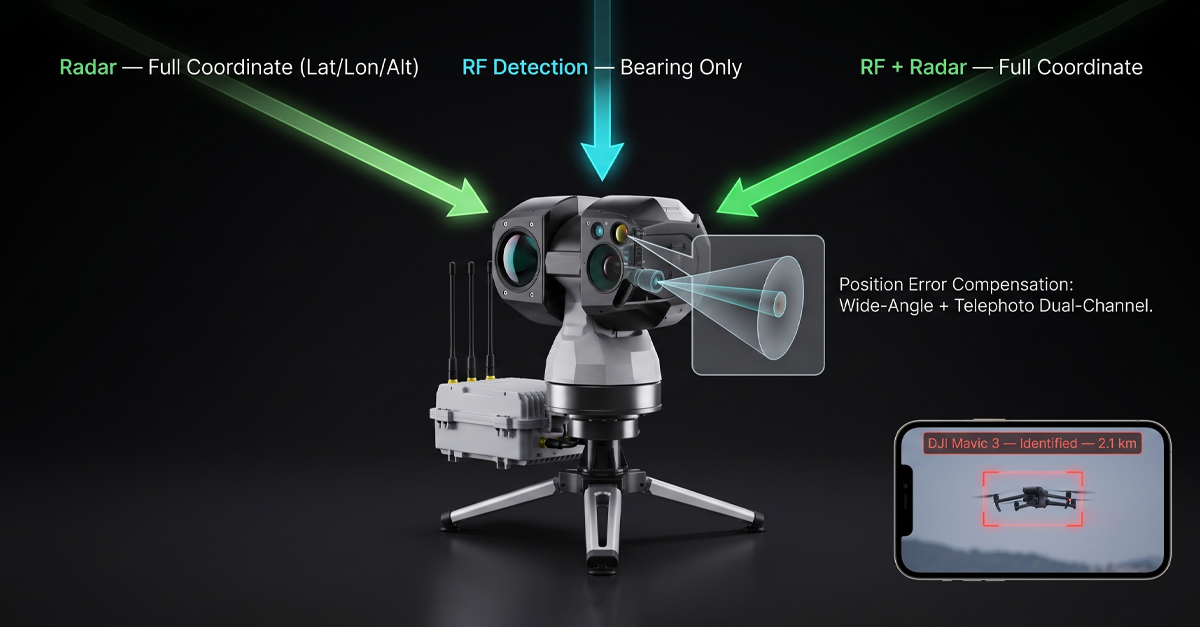
Scenario one: the unlicensed drone light show

A 100-drone light show at a major festival looks impressive from the ground. From a detection standpoint, it looks like a problem with a hundred moving parts. The DGLV report highlighted that organizers were running these shows under the Open category, which allows individual drone operation but explicitly excludes coordinated multi-drone flights. The Specific category, which does permit such operations, requires authorization, risk assessment, and an operational safety case. Running a light show without that authorization is no longer a paperwork oversight. It is a violation, and Europe is treating it as one.

For the venue security team, the operational question is: how do you distinguish an unauthorized light show from a single hostile drone that happens to be flying near clusters of authorized activity? The answer sits in the T100’s multi-source fusion guidance. The system accepts pointing commands from radar systems that provide latitude, longitude, and altitude, and from RF detection systems that provide bearing information. When the detection layer flags multiple contacts in a tight cluster, the T100 slews to the area, activates its wide-angle camera for area search, and then shifts to the telephoto channel the moment a drone enters the field of view.

The 200 TOPS edge computing unit runs classification models on-device. It distinguishes drones from birds, kites, and other airborne objects without sending frames to a cloud server and waiting for a response. This matters at a festival where cellular networks are saturated by 80,000 attendees. Cloud-based AI would choke on the latency. The T100’s models run locally, which means the classification arrives while the target is still in frame.

If the visual feed confirms a coordinated formation with uniform spacing, uniform altitude, and the flight pattern of a preprogrammed light show, the operator sees it, logs it, and escalates through the event’s communication protocol rather than triggering an alarm. If the visual feed shows a single drone breaking formation, changing altitude erratically, or heading toward the crowd, the operator has an entirely different decision to make. The T100 does not make that decision. It makes sure the operator is not making it blind.

Scenario two: the 500-meter drone

A drone at 500 meters is invisible to the naked eye. It is barely visible to a standard security camera with a fixed wide-angle lens. At that altitude, the acoustic signature is gone. The drone is a silent speck. If the operator has a zoom camera, but it takes 20 seconds to acquire the target, the drone has moved 300 meters at a modest 15 meters per second. The window for visual verification closes before the camera even finishes focusing.

The T100 closes that window with two design choices. First is the active search pattern. When guidance data from radar or RF arrives, the T100 does not simply point at the reported azimuth and wait. It executes a predefined scan pattern, either grid or 3-by-3, with real-time AI detection running on every frame. The wide-angle channel covers a broader sector. The telephoto channel zooms on the first detected target. The moment the AI pipeline detects a drone in any frame of the scan, the system switches from search mode to tracking mode automatically. The operator does not manually slew, zoom, or hunt. The system acquires.

Second is the position error compensation. Guidance data from an RF system carries inherent uncertainty. Signal reflection off buildings, multipath from terrain, and the drone’s own movement during the pointing cycle all contribute to a bearing error that can push the target outside a narrow telephoto field of view. The T100’s wide-angle plus telephoto dual-channel architecture absorbs that error. The wide-angle channel captures the sector that contains the target. The telephoto channel zooms in on the specific contact within that sector. In our own testing, this architecture supports higher position deviations than conventional single-channel EO systems can tolerate. For an operator tracking a 500-meter drone that a bearing-only RF system can only locate to within a few degrees, the error compensation is the difference between acquiring the target and watching it disappear into the cloud.

Why deployment speed matters for temporary no-fly zones

The Belgian violations did not happen at permanent installations. They happened at temporary event no-fly zones. Rock Werchter runs for four days. The Spa Grand Prix runs for three. Each venue has a no-fly zone that exists for less than a week, and the detection equipment arrives, gets set up, and needs to be operational before the first gate opens.

In the conventional EO market, deployment is slow. The unit needs manual compass calibration. The focus needs adjustment to compensate for the temperature difference between storage and the summer field conditions. Integration with the radar or RF system that brought the unit to the event requires a technician to configure communication protocols, coordinate axes, and test handoff sequences. A two-hour setup window before the first crowd arrives is easily consumed by integration debugging between equipment from different manufacturers.

The T100 was designed to invert that timeline. Auto-compass calibration means the unit orients itself after a single initial calibration. No drone flyover. No auxiliary reference hardware. The unit powers on, orients, and is ready to accept guidance data. Integration with radar and RF systems is plug-and-play. Our team built the T100 to work natively with our own counter-drone products, including the D5-Air, D5-B, DF5 MAX, and H3 Pro detection systems. And it integrates directly with third-party radar and RF equipment through standard guidance protocols. The result, measured in our own field deployments, is a setup time of approximately ten minutes from unboxing to operational readiness.

The blind spot nobody talks about: what happens when jamming starts

There is an operational reality in counter-drone deployments that most product brochures skip. When jamming activates, RF detection goes silent. The jammer is transmitting across the very bands the detector is listening to. No detection signal. No updated guidance data. And yet, at that exact moment, the security team needs to know one thing more than any other: is the jamming working?

The T100 answers that question optically. When the RF detection layer drops offline because jamming is active, the T100 keeps watching. The thermal channel tracks the drone’s heat signature. The visible channel confirms its visual profile. The tracking algorithm maintains a lock, and the operator sees the target’s behavior in real time. If the drone descends, changes heading, or begins an uncontrolled fall, the operator confirms the jamming is effective. If the drone continues on course, the operator knows the frequency coverage needs adjustment. Either way, the operator has an answer. Without an EO/IR system in the stack, the operator has a blank screen and radio silence that could mean anything.
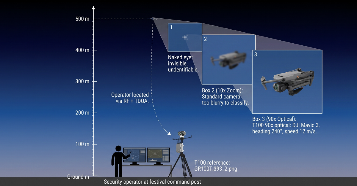
This is not a theoretical scenario. The DGLV report did not mention jamming because the regulator’s role is to document violations, not to prescribe the neutralization response. But for integrators who design the full detect-to-neutralize chain, the handoff gap between RF and jamming is a known vulnerability. The T100 closes it.

Edge AI: why the model has to run on the device, not in the cloud

The T100 packs 200 TOPS of local computing power. That number matters for three reasons that stack in the event-security context.

First, latency. A camera frame arrives at the processing unit. The AI model detects an object, classifies it, and returns a label before the next frame arrives. This happens at the frame rate of the camera, on the device. No round-trip to a cloud inference server. No 4G congestion at a festival. No intermittent connectivity at a rural venue. The classification pipeline runs regardless of what the cellular network is doing.

Second, model specificity. The T100’s deep learning pipeline distinguishes drones, birds, kites, and other airborne objects. In a field test at 500 meters, a bird circling a thermal and a drone hovering can look nearly identical to a basic motion-detection algorithm. The T100’s models are trained on the features that separate them: motion pattern, aspect ratio over time, thermal signature profile, and wing-flap frequency versus rotor-blade frequency. The edge unit runs multiple models simultaneously. If a specific deployment site introduces a new false-alarm source, our team can retrain the models on site-specific data and update the unit.

Third, what the model output enables is that once the AI pipeline classifies a contact as a drone, the T100’s tracking algorithm locks on. It combines correlation filtering, deep feature tracking, and edge tracking into a fused lock that holds through partial occlusion, background clutter, and rapid changes in the target’s aspect angle. The operator sees a stable track with a bounding box and a classification label, not a jittering crosshair that wanders off target whenever the drone banks.

The regulatory direction: Europe is raising the bar on event airspace

The Belgian DGLV warning is the latest signal in what is now a clear trajectory across Europe. France has been running its own event-season enforcement campaigns, with dedicated drone detection units deployed at major festivals and sporting events. Germany passed updated airspace legislation that gives local authorities the power to impose and enforce temporary no-fly zones with real-time monitoring requirements. The Netherlands is piloting a centralized drone traffic management platform that connects venue-level detection data to a national airspace picture.

Each of these developments adds a requirement to the event security integrator’s checklist. Detection coverage is not enough. The detection layer needs to produce verified identification that can be logged, timestamped, and submitted as evidence if a violation leads to prosecution. A radar track labeled ‘unknown contact’ does not meet that standard. A visual confirmation with a 4K image of the drone, its heading, and its altitude does. The T100, by design, captures and timestamps every detection and track event. The data is exportable for incident reporting, and it is structured to feed into the kind of centralized airspace monitoring platforms that the Netherlands and others are piloting.

Integration: EO/IR that works with what you already have

One of the persistent friction points in counter-drone deployment, and one our team identified in our own market research before we designed the T100, is that EO/IR systems, radar systems, and RF detection systems typically come from different manufacturers. The integrator spends hours, sometimes days, making them talk to each other. Guidance handoffs fail. Coordinate systems do not align. The radar reports a target at 47 degrees, the EO unit interprets that as 49 degrees, and the drone flies through the two-degree gap while the systems argue about calibration.
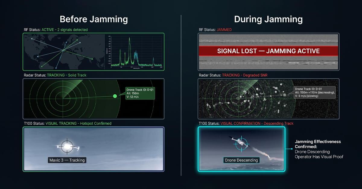
The T100 was engineered to reduce that friction as close to zero as possible. With LZ TECH’s own products, the integration is native. Connect a D5-Air, D5-B, DF5 MAX, or H3 Pro to the T100, and the guidance handoff works out of the box. With third-party radar and RF equipment, the T100 supports both bearing-only guidance and full-coordinate guidance modes. The unit accepts standard protocol interfaces. Once connected, the commissioning test confirms guidance accuracy, and the system is operational.

For venues that already own RF or radar systems, the T100 adds visual verification without replacing existing investments. Our team has deployed T100 units alongside previously purchased third-party radar at correctional facilities and government sites. The integration is fast because the guidance interface is simple: give the T100 a bearing or a coordinate, and it points, searches, and acquires.

The takeaway from the Belgian summer

The DGLV report is short. Dozens of violations. Dozens of events. Two clear violation categories. A regulator publicly signaling that the Open category is not a loophole for coordinated drone operations and that temporary no-fly zones will be enforced, not advised.

For the integrators and venue operators who build the detection stacks, the report confirms something that has been building for two years: detection alone does not close an airspace. RF tells you a drone is transmitting. Radar tells you something is at a range and bearing. Neither one answers the question that the security controller needs answered: what is it, where is it going, and do I need to act.

An EO/IR system like the T100 answers those questions. It verifies. It classifies. It tracks. It keeps watching when the RF layer goes dark. It deploys in ten minutes on a temporary event site. It feeds verified data into the incident log that a regulator will ask for. And it does all of this with the sensor fusion architecture that separates a counter-drone system from a collection of hardware on separate tripods.

As the European event season heats up and regulators move from warnings to enforcement, the gap between what RF and radar can tell you and what an optical system can confirm is no longer a technical nuance. It is the gap between compliance and a violation report with your venue’s name at the top.